
 Search
December 1st-2nd Winter Storm Observations
Page 13 of 22 •  1 ... 8 ... 12, 13, 14 ... 17 ... 22
 ![]()
Re: December 1st-2nd Winter Storm Observations
![]() by Frank_Wx Mon Dec 02, 2019 11:34 am
by Frank_Wx Mon Dec 02, 2019 11:34 am
dsix85 wrote:Does this shut down earlier now bc the onset of precipitation starting earlier than anticipated ?
Yes a little bit. Should end for west/northwest sections between 10-11pm and 2-3am for coast
Frank_Wx- Godzilla Seeker

- Posts : 21305
Join date : 2013-01-05 -

Re: December 1st-2nd Winter Storm Observations
![]() by Frank_Wx Mon Dec 02, 2019 11:37 am
by Frank_Wx Mon Dec 02, 2019 11:37 am
Frank_Wx wrote:Final call snow map - includes today's snowfall as well
Look for light to moderate snow/sleet/freezing rain to begin between 11am-1pm today from southwest to northeast. From CNJ to NE NJ and NYC, expect the wintry precip to changeover to rain around 3-4pm, maybe a little earlier. Areas in a mix (N&W of NYC) may see minor snow accumulations, but for the most part, will be in a mix with dangerous icing developing this evening. Please avoid roads if possible.
The summary for today is little to no snow accumulations and if they do happen it will be N&W of NYC, maybe 1-3".
The overnight hours things get interesting. The secondary low is poised to develop off the coast of NJ but staying very close to the coast, well inside the 40/70 BM. CNJ, NYC and LI could be in a dry slot overnight into the morning hours with either light rain or no precip falling. N&W will continue seeing a mix - even into the overnight hours - but will notice it slowly changing to all snow by the morning. This is where the secondary low takes hold and has snow falling over the area almost all day. Mix/rain line will gradually shifts south-southeast throughout the day. For NYC, that changeover may not happen until 4-5pm. Any precip before then should be mainly rain, which is why accumulations for immediate NYC are cut down. Mid-level centers are on top of us during the day, so 850mb temps are mild stretching from NJ shore to LI into CT.
The CCB that develops - it will develop - will drop additional snowfall over a localized region. Where I have the yellow circle there is the possibility of additional snow, maybe as much as 6" in some spots. Worse conditions will be from 4pm-12am with moderate to heavy snow falling.
Snow will come to an end between 4-5am on Tuesday.
Have fun tracking everyone!!
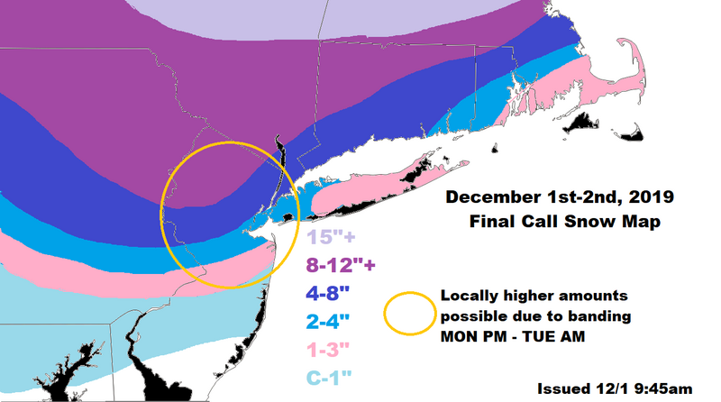
As for this map I still feel ok about it although I wish I expanded the yellow circle further south to encompass more of CNJ and East to include more of LI. I think the 4-8 can be expanded slightly S&E, and the 2-4 replaces the 1-3 across LI. Keep in mind we’re still uncertain about where the area of subsidence develops that will drastically cut down snow accumulations for some people. Also, these bands could “snow” themselves out at some point after the secondary stalls as the trough tries to go negative a bit.
Frank_Wx- Godzilla Seeker
- Posts : 21305
Join date : 2013-01-05 -
Re: December 1st-2nd Winter Storm Observations
![]() by billg315 Mon Dec 02, 2019 11:40 am
by billg315 Mon Dec 02, 2019 11:40 am


billg315- Advanced Forecaster - Mod

- Posts : 4462
Reputation : 185
Join date : 2015-01-24
Age : 50
Location : Flemington, NJ
Re: December 1st-2nd Winter Storm Observations
![]() by jmanley32 Mon Dec 02, 2019 11:43 am
by jmanley32 Mon Dec 02, 2019 11:43 am

jmanley32- Senior Enthusiast

- Posts : 20512
Reputation : 108
Join date : 2013-12-12
Age : 42
Location : Yonkers, NY
Re: December 1st-2nd Winter Storm Observations
![]() by hyde345 Mon Dec 02, 2019 11:44 am
by hyde345 Mon Dec 02, 2019 11:44 am

hyde345- Pro Enthusiast

- Posts : 1082
Reputation : 48
Join date : 2013-01-08
Location : Hyde Park, NY
Re: December 1st-2nd Winter Storm Observations
![]() by Frank_Wx Mon Dec 02, 2019 11:44 am
by Frank_Wx Mon Dec 02, 2019 11:44 am

Surface temps above freezing for many but with winds finally out of the N-NW, snow growth, and improved rates we should overcome them.
_________________
_______________________________________________________________________________________________________
CLICK HERE to view NJ Strong Snowstorm Classifications

Frank_Wx- Godzilla Seeker
- Posts : 21305
Reputation : 328
Join date : 2013-01-05
Age : 31
Location : Jersey City, NJ -
Re: December 1st-2nd Winter Storm Observations
![]() by heehaw453 Mon Dec 02, 2019 11:45 am
by heehaw453 Mon Dec 02, 2019 11:45 am

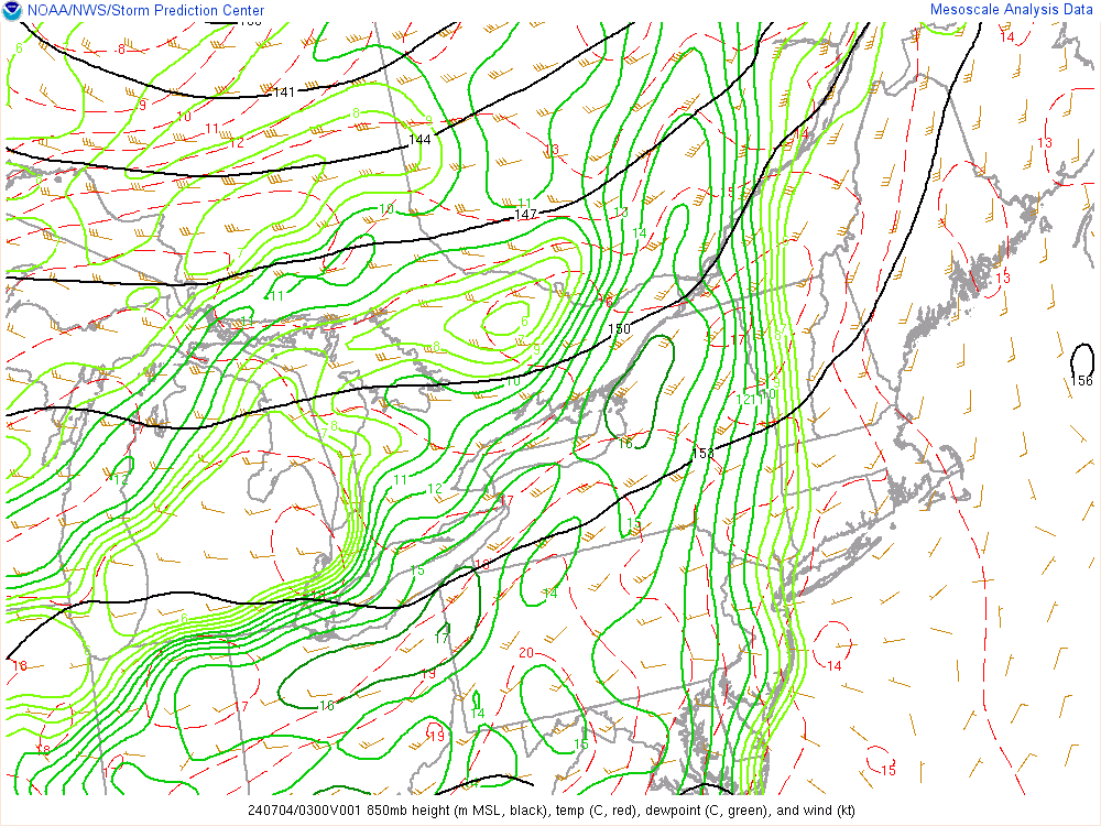
Frontogenesis in purple contours is indicative of lift which should produce some banding.

heehaw453- Advanced Forecaster

- Posts : 3906
Reputation : 86
Join date : 2014-01-20
Location : Bedminster Township, PA Elevation 600' ASL
Re: December 1st-2nd Winter Storm Observations
![]() by heehaw453 Mon Dec 02, 2019 11:52 am
by heehaw453 Mon Dec 02, 2019 11:52 am
billg315 wrote:Views from a heavier band coming through my area:
Nice Pics!
heehaw453- Advanced Forecaster
- Posts : 3906
Reputation : 86
Join date : 2014-01-20
Location : Bedminster Township, PA Elevation 600' ASL
Re: December 1st-2nd Winter Storm Observations
![]() by billg315 Mon Dec 02, 2019 11:52 am
by billg315 Mon Dec 02, 2019 11:52 am
Frank_Wx wrote:
Surface temps above freezing for many but with winds finally out of the N-NW, snow growth, and improved rates we should overcome them.
I’ve got 34* here but with this heavier band it is now sticking to all untreated/less traveled paved surfaces.
billg315- Advanced Forecaster - Mod
- Posts : 4462
Reputation : 185
Join date : 2015-01-24
Age : 50
Location : Flemington, NJ
Re: December 1st-2nd Winter Storm Observations
![]() by DAYBLAZER Mon Dec 02, 2019 11:54 am
by DAYBLAZER Mon Dec 02, 2019 11:54 am

DAYBLAZER- Posts : 228
Reputation : 20
Join date : 2017-03-12
Location : Hopatcong, NJ Sussex County
Re: December 1st-2nd Winter Storm Observations
![]() by Sanchize06 Mon Dec 02, 2019 11:55 am
by Sanchize06 Mon Dec 02, 2019 11:55 am
Sanchize06- Senior Enthusiast
- Posts : 1041
Reputation : 21
Join date : 2013-02-05
Location : Union Beach, NJ
Re: December 1st-2nd Winter Storm Observations
![]() by frank 638 Mon Dec 02, 2019 11:56 am
by frank 638 Mon Dec 02, 2019 11:56 am
frank 638- Senior Enthusiast
- Posts : 2824
Reputation : 37
Join date : 2016-01-01
Age : 40
Location : bronx ny
Re: December 1st-2nd Winter Storm Observations
![]() by essexcountypete Mon Dec 02, 2019 11:59 am
by essexcountypete Mon Dec 02, 2019 11:59 am

essexcountypete- Pro Enthusiast
- Posts : 783
Reputation : 12
Join date : 2013-12-09
Location : Bloomfield, NJ
Re: December 1st-2nd Winter Storm Observations
![]() by heehaw453 Mon Dec 02, 2019 12:07 pm
by heehaw453 Mon Dec 02, 2019 12:07 pm

heehaw453- Advanced Forecaster
- Posts : 3906
Reputation : 86
Join date : 2014-01-20
Location : Bedminster Township, PA Elevation 600' ASL
Re: December 1st-2nd Winter Storm Observations
![]() by amugs Mon Dec 02, 2019 12:08 pm
by amugs Mon Dec 02, 2019 12:08 pm

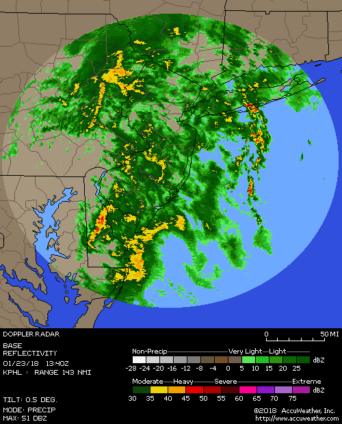
GFS ENS saying 6" plus extremely likely in tehareas in red
_________________
Mugs
AKA:King: Snow Weenie
Self Proclaimed
WINTER 2014-15 : 55.12" +.02 for 6 coatings (avg. 35")
WINTER 2015-16 Total - 29.8" (Avg 35")
WINTER 2016-17 : 39.5" so far

amugs- Advanced Forecaster - Mod
- Posts : 15093
Reputation : 213
Join date : 2013-01-07
Age : 54
Location : Hillsdale,NJ
Re: December 1st-2nd Winter Storm Observations
![]() by aiannone Mon Dec 02, 2019 12:10 pm
by aiannone Mon Dec 02, 2019 12:10 pm
_________________
-Alex Iannone-

aiannone- Senior Enthusiast - Mod
- Posts : 4813
Reputation : 92
Join date : 2013-01-07
Location : Saint James, LI (Northwest Suffolk Co.)
Re: December 1st-2nd Winter Storm Observations
![]() by jmanley32 Mon Dec 02, 2019 12:10 pm
by jmanley32 Mon Dec 02, 2019 12:10 pm
jmanley32- Senior Enthusiast
- Posts : 20512
Reputation : 108
Join date : 2013-12-12
Age : 42
Location : Yonkers, NY
Re: December 1st-2nd Winter Storm Observations
![]() by amugs Mon Dec 02, 2019 12:12 pm
by amugs Mon Dec 02, 2019 12:12 pm
_________________
Mugs
AKA:King: Snow Weenie
Self Proclaimed
WINTER 2014-15 : 55.12" +.02 for 6 coatings (avg. 35")
WINTER 2015-16 Total - 29.8" (Avg 35")
WINTER 2016-17 : 39.5" so far
amugs- Advanced Forecaster - Mod
- Posts : 15093
Reputation : 213
Join date : 2013-01-07
Age : 54
Location : Hillsdale,NJ
Re: December 1st-2nd Winter Storm Observations
![]() by Frank_Wx Mon Dec 02, 2019 12:13 pm
by Frank_Wx Mon Dec 02, 2019 12:13 pm

Convergence off the coast is causing convection to fire up. Not sure any of that actually makes it inland. Seems like the best dynamics are too far from us, but the H5 ULL could try to swing it closer after it passes to our south. It's pretty much there so now or never.

850mb finally off the coast. Once 700mb low gets there we should see frontogenesis spread across the area
_________________
_______________________________________________________________________________________________________
CLICK HERE to view NJ Strong Snowstorm Classifications
Frank_Wx- Godzilla Seeker
- Posts : 21305
Reputation : 328
Join date : 2013-01-05
Age : 31
Location : Jersey City, NJ -
Re: December 1st-2nd Winter Storm Observations
![]() by docstox12 Mon Dec 02, 2019 12:13 pm
by docstox12 Mon Dec 02, 2019 12:13 pm

docstox12- Wx Statistician Guru

- Posts : 8502
Reputation : 222
Join date : 2013-01-07
Age : 73
Location : Monroe NY
Re: December 1st-2nd Winter Storm Observations
![]() by Frank_Wx Mon Dec 02, 2019 12:17 pm
by Frank_Wx Mon Dec 02, 2019 12:17 pm

_________________
_______________________________________________________________________________________________________
CLICK HERE to view NJ Strong Snowstorm Classifications
Frank_Wx- Godzilla Seeker
- Posts : 21305
Reputation : 328
Join date : 2013-01-05
Age : 31
Location : Jersey City, NJ -
Re: December 1st-2nd Winter Storm Observations
![]() by jmanley32 Mon Dec 02, 2019 12:18 pm
by jmanley32 Mon Dec 02, 2019 12:18 pm
jmanley32- Senior Enthusiast
- Posts : 20512
Reputation : 108
Join date : 2013-12-12
Age : 42
Location : Yonkers, NY
Re: December 1st-2nd Winter Storm Observations
![]() by docstox12 Mon Dec 02, 2019 12:19 pm
by docstox12 Mon Dec 02, 2019 12:19 pm
Frank_Wx wrote:
Wow Frank, magnificent!
docstox12- Wx Statistician Guru
- Posts : 8502
Reputation : 222
Join date : 2013-01-07
Age : 73
Location : Monroe NY
Re: December 1st-2nd Winter Storm Observations
![]() by Frank_Wx Mon Dec 02, 2019 12:21 pm
by Frank_Wx Mon Dec 02, 2019 12:21 pm

_________________
_______________________________________________________________________________________________________
CLICK HERE to view NJ Strong Snowstorm Classifications
Frank_Wx- Godzilla Seeker
- Posts : 21305
Reputation : 328
Join date : 2013-01-05
Age : 31
Location : Jersey City, NJ -
Re: December 1st-2nd Winter Storm Observations
![]() by sroc4 Mon Dec 02, 2019 12:23 pm
by sroc4 Mon Dec 02, 2019 12:23 pm
_________________
"In weather and in life, there's no winning and losing; there's only winning and learning."
WINTER 2012/2013 TOTALS 43.65"WINTER 2017/2018 TOTALS 62.85" WINTER 2022/2023 TOTALS 4.9"
WINTER 2013/2014 TOTALS 64.85"WINTER 2018/2019 TOTALS 14.25" WINTER 2023/2024 TOTALS 13.1"
WINTER 2014/2015 TOTALS 71.20"WINTER 2019/2020 TOTALS 6.35"
WINTER 2015/2016 TOTALS 35.00"WINTER 2020/2021 TOTALS 37.75"
WINTER 2016/2017 TOTALS 42.25"WINTER 2021/2022 TOTALS 31.65"

sroc4- Admin
- Posts : 8331
Reputation : 301
Join date : 2013-01-07
Location : Wading River, LI
Re: December 1st-2nd Winter Storm Observations
![]() by sroc4 Mon Dec 02, 2019 12:25 pm
by sroc4 Mon Dec 02, 2019 12:25 pm
amugs wrote:Look at the convection over the ocean east of toms River - swing that puppy thoruh please and those rates would be 1-3" per hr stuff easily
That radar does no justice to the eastern flank of the precip
_________________
"In weather and in life, there's no winning and losing; there's only winning and learning."
WINTER 2012/2013 TOTALS 43.65"WINTER 2017/2018 TOTALS 62.85" WINTER 2022/2023 TOTALS 4.9"
WINTER 2013/2014 TOTALS 64.85"WINTER 2018/2019 TOTALS 14.25" WINTER 2023/2024 TOTALS 13.1"
WINTER 2014/2015 TOTALS 71.20"WINTER 2019/2020 TOTALS 6.35"
WINTER 2015/2016 TOTALS 35.00"WINTER 2020/2021 TOTALS 37.75"
WINTER 2016/2017 TOTALS 42.25"WINTER 2021/2022 TOTALS 31.65"
sroc4- Admin
- Posts : 8331
Reputation : 301
Join date : 2013-01-07
Location : Wading River, LI
Re: December 1st-2nd Winter Storm Observations
![]() by Frank_Wx Mon Dec 02, 2019 12:25 pm
by Frank_Wx Mon Dec 02, 2019 12:25 pm
_________________
_______________________________________________________________________________________________________
CLICK HERE to view NJ Strong Snowstorm Classifications
Frank_Wx- Godzilla Seeker
- Posts : 21305
Reputation : 328
Join date : 2013-01-05
Age : 31
Location : Jersey City, NJ -
Page 13 of 22 • 1 ... 8 ... 12, 13, 14 ... 17 ... 22 ![]()
|
|
|