
 Search
December 1st-2nd Winter Storm Observations
Page 12 of 22 •  1 ... 7 ... 11, 12, 13 ... 17 ... 22
 ![]()
Re: December 1st-2nd Winter Storm Observations
![]() by sroc4 Mon Dec 02, 2019 10:25 am
by sroc4 Mon Dec 02, 2019 10:25 am
sroc4- Admin

- Posts : 8354
Join date : 2013-01-07
Re: December 1st-2nd Winter Storm Observations
![]() by jmanley32 Mon Dec 02, 2019 10:28 am
by jmanley32 Mon Dec 02, 2019 10:28 am
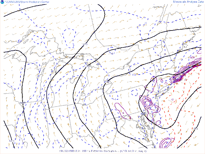
wow that 12 to 15 is literally miles from me. That's impressive and I'll take my 6 to 8 though if Bronx sees 12 to 16 i might be a but salty lol get itFrank_Wx wrote:The RGEM shows a massive band over NYC. Those west and east of this band are in subsidence and see much less. This is going to be some nowcasting event to see where this band develops. Huge bust potential for many places and this now includes N&W of NYC which once was looking like the jackpot.

jmanley32- Senior Enthusiast

- Posts : 20535
Join date : 2013-12-12
Re: December 1st-2nd Winter Storm Observations
![]() by amugs Mon Dec 02, 2019 10:32 am
by amugs Mon Dec 02, 2019 10:32 am
It will be puking snow with very heavy rates from about 1-3PM with this here.
Shades of Nov 2018 here peeps?
Moderately snowing here in Allendale, in school, gonna be a touch ride home everything is covered in white - you know 1st time snowfalls hoe drivers are let alone 1st time drivers - a poop show in the making!!
We are a good 3-4 hours ahead of where it was forecasted
_________________
Mugs
AKA:King: Snow Weenie
Self Proclaimed
WINTER 2014-15 : 55.12" +.02 for 6 coatings (avg. 35")
WINTER 2015-16 Total - 29.8" (Avg 35")
WINTER 2016-17 : 39.5" so far

amugs- Advanced Forecaster - Mod

- Posts : 15095
Reputation : 213
Join date : 2013-01-07
Age : 54
Location : Hillsdale,NJ
Re: December 1st-2nd Winter Storm Observations
![]() by skinsfan1177 Mon Dec 02, 2019 10:32 am
by skinsfan1177 Mon Dec 02, 2019 10:32 am

skinsfan1177- Senior Enthusiast
- Posts : 4485
Reputation : 35
Join date : 2013-01-07
Age : 46
Location : Point Pleasant Boro
Re: December 1st-2nd Winter Storm Observations
![]() by billg315 Mon Dec 02, 2019 10:33 am
by billg315 Mon Dec 02, 2019 10:33 am


billg315- Advanced Forecaster - Mod
- Posts : 4483
Reputation : 185
Join date : 2015-01-24
Age : 50
Location : Flemington, NJ
Re: December 1st-2nd Winter Storm Observations
![]() by amugs Mon Dec 02, 2019 10:41 am
by amugs Mon Dec 02, 2019 10:41 am
Areas in purpel will get smoked then it will pivot east
RGEM smokes Zoo and I
Additional snows
_________________
Mugs
AKA:King: Snow Weenie
Self Proclaimed
WINTER 2014-15 : 55.12" +.02 for 6 coatings (avg. 35")
WINTER 2015-16 Total - 29.8" (Avg 35")
WINTER 2016-17 : 39.5" so far
amugs- Advanced Forecaster - Mod
- Posts : 15095
Reputation : 213
Join date : 2013-01-07
Age : 54
Location : Hillsdale,NJ
Re: December 1st-2nd Winter Storm Observations
![]() by algae888 Mon Dec 02, 2019 10:49 am
by algae888 Mon Dec 02, 2019 10:49 am

algae888- Advanced Forecaster

- Posts : 5311
Reputation : 46
Join date : 2013-02-05
Age : 62
Location : mt. vernon, new york
Re: December 1st-2nd Winter Storm Observations
![]() by billg315 Mon Dec 02, 2019 10:53 am
by billg315 Mon Dec 02, 2019 10:53 am
AN AREA OF HEAVIER SNOW IS AFFECTING HUNTERDON...SOUTHWESTERNMORRIS...SOUTHERN WARREN...MERCER...SOMERSET AND WESTERN MIDDLESEX
COUNTIES
At 1040 AM EST, an area of heavier snow continues to slowly move across portions of Mercer County, western Middlesex County northward to Somerset, Hunterdon, Morris and into Warren counties.
Snowfall rates up to an inch per hour will result in an increase in accumulations on untreated surfaces and also significantly reduce the visibility. Remember, bridges and overpasses tend to be colder and therefore be more slippery.
Conditions can deteriorate rapidly in winter weather situations. Be prepared that roads may become quickly snow covered during heavier bursts of snow. Slow down and allow extra time when traveling.
Locations impacted include Trenton, New Brunswick, Somerville, Somerset, East Brunswick,
Bridgewater, South Brunswick, North Brunswick, Ewing, Dover,
Middlesex, Princeton, Bound Brook, Manville, Hackettstown, Wharton, Washington, Rockaway, Jamesburg and Hightstown.
This includes the following highways Interstate 195 in New Jersey between mile markers 0 and 6.
Interstate 287 in New Jersey between mile markers 8 and 33.
Interstate 295 in New Jersey between mile markers 59 and 76.
Interstate 78 in New Jersey between mile markers 8 and 39.
Interstate 80 in New Jersey between mile markers 25 and 35.
billg315- Advanced Forecaster - Mod
- Posts : 4483
Reputation : 185
Join date : 2015-01-24
Age : 50
Location : Flemington, NJ
Re: December 1st-2nd Winter Storm Observations
![]() by dkodgis Mon Dec 02, 2019 10:54 am
by dkodgis Mon Dec 02, 2019 10:54 am

dkodgis- Senior Enthusiast
- Posts : 2560
Reputation : 98
Join date : 2013-12-29
Re: December 1st-2nd Winter Storm Observations
![]() by billg315 Mon Dec 02, 2019 10:55 am
by billg315 Mon Dec 02, 2019 10:55 am
dkodgis wrote:This has been a strange storm for me. It has steadily snowed since last night but the totals so far are so low. No more than 5 inches it seems but the snow is very compact, heavy, and almost icy. Who is getting the totals then? Not I, not I , not I.
Dude, if you’ve got 5” already don’t complain. For most of us that’s the best we’ll get. Lol.
billg315- Advanced Forecaster - Mod
- Posts : 4483
Reputation : 185
Join date : 2015-01-24
Age : 50
Location : Flemington, NJ
Re: December 1st-2nd Winter Storm Observations
![]() by jmanley32 Mon Dec 02, 2019 10:59 am
by jmanley32 Mon Dec 02, 2019 10:59 am

jmanley32- Senior Enthusiast
- Posts : 20535
Reputation : 108
Join date : 2013-12-12
Age : 43
Location : Yonkers, NY
Re: December 1st-2nd Winter Storm Observations
![]() by CPcantmeasuresnow Mon Dec 02, 2019 11:00 am
by CPcantmeasuresnow Mon Dec 02, 2019 11:00 am
billg315 wrote:dkodgis wrote:This has been a strange storm for me. It has steadily snowed since last night but the totals so far are so low. No more than 5 inches it seems but the snow is very compact, heavy, and almost icy. Who is getting the totals then? Not I, not I , not I.
Dude, if you’ve got 5” already don’t complain. For most of us that’s the best we’ll get. Lol.
You stole my Thunder.
Looking at a little over 3 inches right now OTG but this is solid as a rock concrete that's not going anywhere.
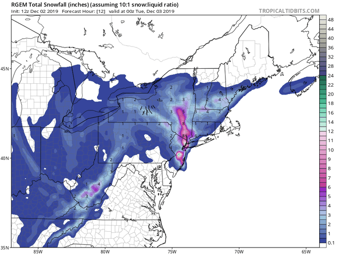
If the Rgem is correct and there's 8 inches yet to come, although it is a fairly narrow band so I'm not counting on it, it will be a pleasant surprise.
Math right now at 14 inches in Albany. The winner by a landslide.

CPcantmeasuresnow- Wx Statistician Guru

- Posts : 7274
Reputation : 230
Join date : 2013-01-07
Age : 103
Location : Eastern Orange County, NY
Re: December 1st-2nd Winter Storm Observations
![]() by Irish Mon Dec 02, 2019 11:00 am
by Irish Mon Dec 02, 2019 11:00 am

Irish- Pro Enthusiast

- Posts : 788
Reputation : 19
Join date : 2019-01-16
Age : 45
Location : Old Bridge, NJ
Re: December 1st-2nd Winter Storm Observations
![]() by jimv45 Mon Dec 02, 2019 11:02 am
by jimv45 Mon Dec 02, 2019 11:02 am
jimv45- Senior Enthusiast
- Posts : 1168
Reputation : 36
Join date : 2013-09-20
Location : Hopewell jct.
Re: December 1st-2nd Winter Storm Observations
![]() by docstox12 Mon Dec 02, 2019 11:04 am
by docstox12 Mon Dec 02, 2019 11:04 am
CPcantmeasuresnow wrote:billg315 wrote:dkodgis wrote:This has been a strange storm for me. It has steadily snowed since last night but the totals so far are so low. No more than 5 inches it seems but the snow is very compact, heavy, and almost icy. Who is getting the totals then? Not I, not I , not I.
Dude, if you’ve got 5” already don’t complain. For most of us that’s the best we’ll get. Lol.
You stole my Thunder.
Looking at a little over 3 inches right now OTG but this is solid as a rock concrete that's not going anywhere.
If the Rgem is correct and there's 8 inches yet to come, although it is a fairly narrow band so I'm not counting on it, it will be a pleasant surprise.
Math right now at 14 inches in Albany. The winner by a landslide.
Those maps show a VERY narrow band with the dreaded substinance on either side of us CP.Definitley going to be a crap shoot later on.
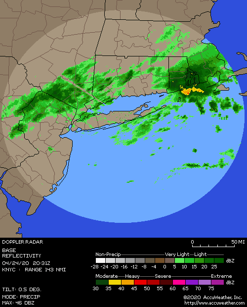
Very light snow again after a lull.Radar looks good now filling in nicely.

docstox12- Wx Statistician Guru
- Posts : 8530
Reputation : 222
Join date : 2013-01-07
Age : 73
Location : Monroe NY
Re: December 1st-2nd Winter Storm Observations
![]() by jmanley32 Mon Dec 02, 2019 11:20 am
by jmanley32 Mon Dec 02, 2019 11:20 am
jmanley32- Senior Enthusiast
- Posts : 20535
Reputation : 108
Join date : 2013-12-12
Age : 43
Location : Yonkers, NY
Re: December 1st-2nd Winter Storm Observations
![]() by Vinnydula Mon Dec 02, 2019 11:23 am
by Vinnydula Mon Dec 02, 2019 11:23 am

Vinnydula- Pro Enthusiast
- Posts : 778
Reputation : 8
Join date : 2013-12-12
Location : Dobbs ferry
Re: December 1st-2nd Winter Storm Observations
![]() by dsix85 Mon Dec 02, 2019 11:23 am
by dsix85 Mon Dec 02, 2019 11:23 am
dsix85- Pro Enthusiast
- Posts : 349
Reputation : 8
Join date : 2014-01-01
Location : New York
Re: December 1st-2nd Winter Storm Observations
![]() by amugs Mon Dec 02, 2019 11:27 am
by amugs Mon Dec 02, 2019 11:27 am

FILLING IN NICE A NICE PASTRY ..no??
_________________
Mugs
AKA:King: Snow Weenie
Self Proclaimed
WINTER 2014-15 : 55.12" +.02 for 6 coatings (avg. 35")
WINTER 2015-16 Total - 29.8" (Avg 35")
WINTER 2016-17 : 39.5" so far
amugs- Advanced Forecaster - Mod
- Posts : 15095
Reputation : 213
Join date : 2013-01-07
Age : 54
Location : Hillsdale,NJ
Re: December 1st-2nd Winter Storm Observations
![]() by Frank_Wx Mon Dec 02, 2019 11:27 am
by Frank_Wx Mon Dec 02, 2019 11:27 am
dsix85 wrote:@Frank- any chance of thundersnow under the heavy bands that set up?
If the HRRR is right with that convective looking radar later this afternoon it’s possible but I don’t think the DBZ bands become that potent
_________________
_______________________________________________________________________________________________________
CLICK HERE to view NJ Strong Snowstorm Classifications

Frank_Wx- Godzilla Seeker
- Posts : 21305
Reputation : 328
Join date : 2013-01-05
Age : 32
Location : Jersey City, NJ -

Re: December 1st-2nd Winter Storm Observations
![]() by Frank_Wx Mon Dec 02, 2019 11:28 am
by Frank_Wx Mon Dec 02, 2019 11:28 am
_________________
_______________________________________________________________________________________________________
CLICK HERE to view NJ Strong Snowstorm Classifications
Frank_Wx- Godzilla Seeker
- Posts : 21305
Reputation : 328
Join date : 2013-01-05
Age : 32
Location : Jersey City, NJ -
Re: December 1st-2nd Winter Storm Observations
![]() by Frank_Wx Mon Dec 02, 2019 11:29 am
by Frank_Wx Mon Dec 02, 2019 11:29 am

_________________
_______________________________________________________________________________________________________
CLICK HERE to view NJ Strong Snowstorm Classifications
Frank_Wx- Godzilla Seeker
- Posts : 21305
Reputation : 328
Join date : 2013-01-05
Age : 32
Location : Jersey City, NJ -
Re: December 1st-2nd Winter Storm Observations
![]() by dsix85 Mon Dec 02, 2019 11:32 am
by dsix85 Mon Dec 02, 2019 11:32 am
dsix85- Pro Enthusiast
- Posts : 349
Reputation : 8
Join date : 2014-01-01
Location : New York
Re: December 1st-2nd Winter Storm Observations
![]() by Frank_Wx Mon Dec 02, 2019 11:33 am
by Frank_Wx Mon Dec 02, 2019 11:33 am
_________________
_______________________________________________________________________________________________________
CLICK HERE to view NJ Strong Snowstorm Classifications
Frank_Wx- Godzilla Seeker
- Posts : 21305
Reputation : 328
Join date : 2013-01-05
Age : 32
Location : Jersey City, NJ -
Re: December 1st-2nd Winter Storm Observations
![]() by billg315 Mon Dec 02, 2019 11:33 am
by billg315 Mon Dec 02, 2019 11:33 am
dsix85 wrote:Does this shut down earlier now bc the onset of precipitation starting earlier than anticipated ?
There is no indication from any of the models I’ve seen today including HRRR of this shutting downs before 2-4 am tomorrow.
billg315- Advanced Forecaster - Mod
- Posts : 4483
Reputation : 185
Join date : 2015-01-24
Age : 50
Location : Flemington, NJ
Re: December 1st-2nd Winter Storm Observations
![]() by Frank_Wx Mon Dec 02, 2019 11:34 am
by Frank_Wx Mon Dec 02, 2019 11:34 am
dsix85 wrote:Does this shut down earlier now bc the onset of precipitation starting earlier than anticipated ?
Yes a little bit. Should end for west/northwest sections between 10-11pm and 2-3am for coast
_________________
_______________________________________________________________________________________________________
CLICK HERE to view NJ Strong Snowstorm Classifications
Frank_Wx- Godzilla Seeker
- Posts : 21305
Reputation : 328
Join date : 2013-01-05
Age : 32
Location : Jersey City, NJ -
Re: December 1st-2nd Winter Storm Observations
![]() by Frank_Wx Mon Dec 02, 2019 11:37 am
by Frank_Wx Mon Dec 02, 2019 11:37 am
Frank_Wx wrote:Final call snow map - includes today's snowfall as well
Look for light to moderate snow/sleet/freezing rain to begin between 11am-1pm today from southwest to northeast. From CNJ to NE NJ and NYC, expect the wintry precip to changeover to rain around 3-4pm, maybe a little earlier. Areas in a mix (N&W of NYC) may see minor snow accumulations, but for the most part, will be in a mix with dangerous icing developing this evening. Please avoid roads if possible.
The summary for today is little to no snow accumulations and if they do happen it will be N&W of NYC, maybe 1-3".
The overnight hours things get interesting. The secondary low is poised to develop off the coast of NJ but staying very close to the coast, well inside the 40/70 BM. CNJ, NYC and LI could be in a dry slot overnight into the morning hours with either light rain or no precip falling. N&W will continue seeing a mix - even into the overnight hours - but will notice it slowly changing to all snow by the morning. This is where the secondary low takes hold and has snow falling over the area almost all day. Mix/rain line will gradually shifts south-southeast throughout the day. For NYC, that changeover may not happen until 4-5pm. Any precip before then should be mainly rain, which is why accumulations for immediate NYC are cut down. Mid-level centers are on top of us during the day, so 850mb temps are mild stretching from NJ shore to LI into CT.
The CCB that develops - it will develop - will drop additional snowfall over a localized region. Where I have the yellow circle there is the possibility of additional snow, maybe as much as 6" in some spots. Worse conditions will be from 4pm-12am with moderate to heavy snow falling.
Snow will come to an end between 4-5am on Tuesday.
Have fun tracking everyone!!
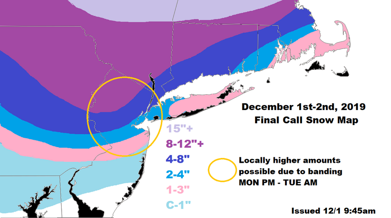
As for this map I still feel ok about it although I wish I expanded the yellow circle further south to encompass more of CNJ and East to include more of LI. I think the 4-8 can be expanded slightly S&E, and the 2-4 replaces the 1-3 across LI. Keep in mind we’re still uncertain about where the area of subsidence develops that will drastically cut down snow accumulations for some people. Also, these bands could “snow” themselves out at some point after the secondary stalls as the trough tries to go negative a bit.
_________________
_______________________________________________________________________________________________________
CLICK HERE to view NJ Strong Snowstorm Classifications
Frank_Wx- Godzilla Seeker
- Posts : 21305
Reputation : 328
Join date : 2013-01-05
Age : 32
Location : Jersey City, NJ -
Page 12 of 22 • 1 ... 7 ... 11, 12, 13 ... 17 ... 22 ![]()
|
|
|