
 Search
February 12th-14th Storm Potential
Page 1 of 24 • 1, 2, 3 ... 12 ... 24 ![]()

February 12th-14th Storm Potential
![]() by NjWeatherGuy Tue Feb 11, 2014 1:14 pm
by NjWeatherGuy Tue Feb 11, 2014 1:14 pm

NjWeatherGuy- Advanced Forecaster

- Posts : 4100
Reputation : 28
Join date : 2013-01-06
Location : Belle Mead, NJ
Re: February 12th-14th Storm Potential
![]() by aiannone Tue Feb 11, 2014 1:16 pm
by aiannone Tue Feb 11, 2014 1:16 pm
_________________
-Alex Iannone-

aiannone- Senior Enthusiast - Mod

- Posts : 4813
Reputation : 92
Join date : 2013-01-07
Location : Saint James, LI (Northwest Suffolk Co.)
Re: February 12th-14th Storm Potential
![]() by NjWeatherGuy Tue Feb 11, 2014 1:18 pm
by NjWeatherGuy Tue Feb 11, 2014 1:18 pm
Mets2695 wrote:All of NJ/NYC/LI and Central and southern CT go to rain on the 12z euro. It went about 30mi west
Not true, looked at the wxbell map and freezing line is just a hair west of I95. Like I said a more amplified trend is a good thing.
NjWeatherGuy- Advanced Forecaster
- Posts : 4100
Reputation : 28
Join date : 2013-01-06
Location : Belle Mead, NJ
Re: February 12th-14th Storm Potential
![]() by aiannone Tue Feb 11, 2014 1:20 pm
by aiannone Tue Feb 11, 2014 1:20 pm

_________________
-Alex Iannone-
aiannone- Senior Enthusiast - Mod
- Posts : 4813
Reputation : 92
Join date : 2013-01-07
Location : Saint James, LI (Northwest Suffolk Co.)
Re: February 12th-14th Storm Potential
![]() by Frank_Wx Tue Feb 11, 2014 1:20 pm
by Frank_Wx Tue Feb 11, 2014 1:20 pm
I need to look at H5 maps and see if this makes any sense
_________________
_______________________________________________________________________________________________________
CLICK HERE to view NJ Strong Snowstorm Classifications

Frank_Wx- Godzilla Seeker

- Posts : 21305
Reputation : 328
Join date : 2013-01-05
Age : 31
Location : Jersey City, NJ -

Re: February 12th-14th Storm Potential
![]() by Frank_Wx Tue Feb 11, 2014 1:20 pm
by Frank_Wx Tue Feb 11, 2014 1:20 pm
_________________
_______________________________________________________________________________________________________
CLICK HERE to view NJ Strong Snowstorm Classifications
Frank_Wx- Godzilla Seeker
- Posts : 21305
Reputation : 328
Join date : 2013-01-05
Age : 31
Location : Jersey City, NJ -
Re: February 12th-14th Storm Potential
![]() by aiannone Tue Feb 11, 2014 1:21 pm
by aiannone Tue Feb 11, 2014 1:21 pm
_________________
-Alex Iannone-
aiannone- Senior Enthusiast - Mod
- Posts : 4813
Reputation : 92
Join date : 2013-01-07
Location : Saint James, LI (Northwest Suffolk Co.)
Re: February 12th-14th Storm Potential
![]() by aiannone Tue Feb 11, 2014 1:22 pm
by aiannone Tue Feb 11, 2014 1:22 pm

_________________
-Alex Iannone-
aiannone- Senior Enthusiast - Mod
- Posts : 4813
Reputation : 92
Join date : 2013-01-07
Location : Saint James, LI (Northwest Suffolk Co.)
Re: February 12th-14th Storm Potential
![]() by NjWeatherGuy Tue Feb 11, 2014 1:22 pm
by NjWeatherGuy Tue Feb 11, 2014 1:22 pm
Mets2695 wrote:
Beautiful IMBY. Looks like the NW may finally cash in on a large dynamic storm. Ive missed out on the larger half of the totals for each "blizzard" of the past 5 years. Were overdue. I have no sympathy to the coast. Besides this is still not locked in yet.
NjWeatherGuy- Advanced Forecaster
- Posts : 4100
Reputation : 28
Join date : 2013-01-06
Location : Belle Mead, NJ
Re: February 12th-14th Storm Potential
![]() by aiannone Tue Feb 11, 2014 1:26 pm
by aiannone Tue Feb 11, 2014 1:26 pm
_________________
-Alex Iannone-
aiannone- Senior Enthusiast - Mod
- Posts : 4813
Reputation : 92
Join date : 2013-01-07
Location : Saint James, LI (Northwest Suffolk Co.)
Re: February 12th-14th Storm Potential
![]() by amugs Tue Feb 11, 2014 1:27 pm
by amugs Tue Feb 11, 2014 1:27 pm
_________________
Mugs
AKA:King: Snow Weenie
Self Proclaimed
WINTER 2014-15 : 55.12" +.02 for 6 coatings (avg. 35")
WINTER 2015-16 Total - 29.8" (Avg 35")
WINTER 2016-17 : 39.5" so far

amugs- Advanced Forecaster - Mod
- Posts : 15093
Reputation : 213
Join date : 2013-01-07
Age : 54
Location : Hillsdale,NJ
Re: February 12th-14th Storm Potential
![]() by Math23x7 Tue Feb 11, 2014 1:34 pm
by Math23x7 Tue Feb 11, 2014 1:34 pm
And also, I can't believe this thread is at over 1,000 posts...
Math23x7- Wx Statistician Guru

- Posts : 2379
Reputation : 68
Join date : 2013-01-08
Re: February 12th-14th Storm Potential
![]() by jmanley32 Tue Feb 11, 2014 1:34 pm
by jmanley32 Tue Feb 11, 2014 1:34 pm
Last edited by jmanley32 on Tue Feb 11, 2014 1:35 pm; edited 1 time in total

jmanley32- Senior Enthusiast

- Posts : 20516
Reputation : 108
Join date : 2013-12-12
Age : 42
Location : Yonkers, NY
Re: February 12th-14th Storm Potential
![]() by jmanley32 Tue Feb 11, 2014 1:34 pm
by jmanley32 Tue Feb 11, 2014 1:34 pm
jmanley32- Senior Enthusiast
- Posts : 20516
Reputation : 108
Join date : 2013-12-12
Age : 42
Location : Yonkers, NY
Re: February 12th-14th Storm Potential
![]() by RJB8525 Tue Feb 11, 2014 1:37 pm
by RJB8525 Tue Feb 11, 2014 1:37 pm
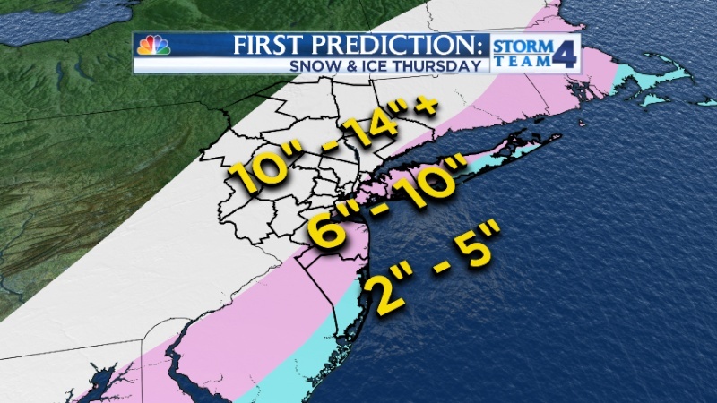
Mets2695 wrote:*NEW* updated snowfall forecast for #NYC tri-state area. Totals have been increased significantly: @NBCNewYork
i womder if ABC will update tonight,Bill at 12 moved 10-16 watch stretched more southward..should be interesting if they put NYC in this category now seems to be a battle zone

RJB8525- Senior Enthusiast
- Posts : 1994
Reputation : 28
Join date : 2013-02-06
Age : 38
Location : Hackettstown, NJ
Re: February 12th-14th Storm Potential
![]() by Frank_Wx Tue Feb 11, 2014 1:38 pm
by Frank_Wx Tue Feb 11, 2014 1:38 pm
amugs wrote:Frank the SST around this area are below normal (29-32* from buoy data)which should also help with the storms E NE winds keeping the rain/snow line pinned S&E.
Just like hurricanes, these type of storms like to follow the warmer sea surface temperatures. It's possible
_________________
_______________________________________________________________________________________________________
CLICK HERE to view NJ Strong Snowstorm Classifications
Frank_Wx- Godzilla Seeker
- Posts : 21305
Reputation : 328
Join date : 2013-01-05
Age : 31
Location : Jersey City, NJ -
Re: February 12th-14th Storm Potential
![]() by jmanley32 Tue Feb 11, 2014 1:40 pm
by jmanley32 Tue Feb 11, 2014 1:40 pm
Frank_Wx wrote:amugs wrote:Frank the SST around this area are below normal (29-32* from buoy data)which should also help with the storms E NE winds keeping the rain/snow line pinned S&E.
Just like hurricanes, these type of storms like to follow the warmer sea surface temperatures. It's possible
i like the sound of this : )
jmanley32- Senior Enthusiast
- Posts : 20516
Reputation : 108
Join date : 2013-12-12
Age : 42
Location : Yonkers, NY
Re: February 12th-14th Storm Potential
![]() by jmanley32 Tue Feb 11, 2014 1:42 pm
by jmanley32 Tue Feb 11, 2014 1:42 pm
jmanley32- Senior Enthusiast
- Posts : 20516
Reputation : 108
Join date : 2013-12-12
Age : 42
Location : Yonkers, NY
Re: February 12th-14th Storm Potential
![]() by sabamfa Tue Feb 11, 2014 1:46 pm
by sabamfa Tue Feb 11, 2014 1:46 pm
sabamfa- Pro Enthusiast

- Posts : 246
Reputation : 2
Join date : 2013-11-05
Age : 37
Location : Wayne, NJ
Re: February 12th-14th Storm Potential
![]() by jimv45 Tue Feb 11, 2014 1:47 pm
by jimv45 Tue Feb 11, 2014 1:47 pm
jimv45- Senior Enthusiast
- Posts : 1168
Reputation : 36
Join date : 2013-09-20
Location : Hopewell jct.
Re: February 12th-14th Storm Potential
![]() by Frank_Wx Tue Feb 11, 2014 1:48 pm
by Frank_Wx Tue Feb 11, 2014 1:48 pm
sabamfa wrote:Are we still looking at a 2-3AM Thursday start time? Any thoughts yet on how much snow by 5AM or 6AM?
Yes and could have 3-6 inches on the ground by 6-7am
_________________
_______________________________________________________________________________________________________
CLICK HERE to view NJ Strong Snowstorm Classifications
Frank_Wx- Godzilla Seeker
- Posts : 21305
Reputation : 328
Join date : 2013-01-05
Age : 31
Location : Jersey City, NJ -
Re: February 12th-14th Storm Potential
![]() by Finster712 Tue Feb 11, 2014 1:50 pm
by Finster712 Tue Feb 11, 2014 1:50 pm
What are you thinking is the end time for this storm?
Finster712- Posts : 1
Reputation : 0
Join date : 2013-11-07
Age : 38
Location : Pompton Lakes, NJ
Re: February 12th-14th Storm Potential
![]() by algae888 Tue Feb 11, 2014 1:54 pm
by algae888 Tue Feb 11, 2014 1:54 pm

algae888- Advanced Forecaster
- Posts : 5311
Reputation : 46
Join date : 2013-02-05
Age : 61
Location : mt. vernon, new york
Re: February 12th-14th Storm Potential
![]() by NjWeatherGuy Tue Feb 11, 2014 1:56 pm
by NjWeatherGuy Tue Feb 11, 2014 1:56 pm
http://forums.accuweather.com/index.php?act=attach&type=post&id=226634
1.6" QPF snow for CNJ
NjWeatherGuy- Advanced Forecaster
- Posts : 4100
Reputation : 28
Join date : 2013-01-06
Location : Belle Mead, NJ
Re: February 12th-14th Storm Potential
![]() by algae888 Tue Feb 11, 2014 2:01 pm
by algae888 Tue Feb 11, 2014 2:01 pm
NjWeatherGuy wrote:GGEM snowfall, beautiful despite the warm look.
http://forums.accuweather.com/index.php?act=attach&type=post&id=226634
1.6" QPF snow for CNJ
that map puts me in the 40-50MM which is about 15-18" of snow i think. i'll take that in a heart beat. still GGEM gives me about 6-8 hrs of slop
algae888- Advanced Forecaster
- Posts : 5311
Reputation : 46
Join date : 2013-02-05
Age : 61
Location : mt. vernon, new york
Page 1 of 24 • 1, 2, 3 ... 12 ... 24 ![]()
|
|
|