January 18th Winter Storm Looms
+24
Snow88
frank 638
aiannone
brownie
nutleyblizzard
HectorO
algae888
hyde345
bobjohnsonforthehall
weatherwatchermom
phil155
GreyBeard
billg315
heehaw453
dkodgis
amugs
sroc4
docstox12
Dunnzoo
CPcantmeasuresnow
jmanley32
mwilli
essexcountypete
Frank_Wx
28 posters
Page 2 of 6 •  1, 2, 3, 4, 5, 6
 Re: January 18th Winter Storm Looms
billg315 wrote:Here are my Sudden Thoughts and Second Thoughts (RIP Bill Lyon):
A. The temperature profiles on the GFS have trended colder over the past 72 hours for Saturday. A couple days ago I was forecast to approach 40 degrees by Saturday evening. Now I am unlikely to get above 35 degrees (and even that only very briefly at the end of the storm Saturday night). This indicates the strength of the High Pressure and how difficult it will be to scour out the cold air. This bodes well for prolonged front-end thump snows most of the day Saturday.
B. The NAM is still out of range but the 12z has Friday evening temperatures in the low 20s in SNJ and the teens in CNJ/NNJ. If true, temps could be in the teens almost statewide by Saturday morning which would be consistent with what I mentioned in Point A. It will take a long time to warm those temps up.
C. Most of the state is at or below freezing up until almost the end of the storm Saturday evening. The exception is the coast. The 850 freezing line is southeast of most of the state for most of the event. While most areas probably do change to rain before ending -- I think for areas away from the immediate coast that will be "after the damage is done" so to speak in terms of snow accumulations.
D. Frank's 3-6" sounds like a solid guess for most of the state at this point, but with delayed changeover I wouldn't be surprised if areas further North and West hit 7 or 8" out of this.
E. Timing has shifted a bit. Originally looked to start Friday night. Now looks more like snow spreading into the area late morning Saturday and getting heavier during the afternoon and evening before winding down/changing to rain Saturday night. This means Saturday morning may start just cloudy, but most of Saturday afternoon and evening may be very snowy across the area.
Those are my impressions for now.
Nice write up. I think though just as important as temps will be where the best forcing occurs. The H7 strong jet stream winds (70 knots+) will cause lift and where that sets up determines who gets 6". If that sets up further west then we will struggle to get 3 inches even NW of 95. That is a rather fine detail that we just don't know yet. All IMHO of course.
heehaw453- Advanced Forecaster

- Posts : 3906
Join date : 2014-01-20
 Re: January 18th Winter Storm Looms
heehaw453 wrote:billg315 wrote:Here are my Sudden Thoughts and Second Thoughts (RIP Bill Lyon):
A. The temperature profiles on the GFS have trended colder over the past 72 hours for Saturday. A couple days ago I was forecast to approach 40 degrees by Saturday evening. Now I am unlikely to get above 35 degrees (and even that only very briefly at the end of the storm Saturday night). This indicates the strength of the High Pressure and how difficult it will be to scour out the cold air. This bodes well for prolonged front-end thump snows most of the day Saturday.
B. The NAM is still out of range but the 12z has Friday evening temperatures in the low 20s in SNJ and the teens in CNJ/NNJ. If true, temps could be in the teens almost statewide by Saturday morning which would be consistent with what I mentioned in Point A. It will take a long time to warm those temps up.
C. Most of the state is at or below freezing up until almost the end of the storm Saturday evening. The exception is the coast. The 850 freezing line is southeast of most of the state for most of the event. While most areas probably do change to rain before ending -- I think for areas away from the immediate coast that will be "after the damage is done" so to speak in terms of snow accumulations.
D. Frank's 3-6" sounds like a solid guess for most of the state at this point, but with delayed changeover I wouldn't be surprised if areas further North and West hit 7 or 8" out of this.
E. Timing has shifted a bit. Originally looked to start Friday night. Now looks more like snow spreading into the area late morning Saturday and getting heavier during the afternoon and evening before winding down/changing to rain Saturday night. This means Saturday morning may start just cloudy, but most of Saturday afternoon and evening may be very snowy across the area.
Those are my impressions for now.
Nice write up. I think though just as important as temps will be where the best forcing occurs. The H7 strong jet stream winds (70 knots+) will cause lift and where that sets up determines who gets 6". If that sets up further west then we will struggle to get 3 inches even NW of 95. That is a rather fine detail that we just don't know yet. All IMHO of course.
And the surface low seems to drift further and further north on each GFS run. Fankly I'm puzzled it stays as cold as it does with the low that far to our north.
CPcantmeasuresnow- Wx Statistician Guru

- Posts : 7274
Join date : 2013-01-07
 Re: January 18th Winter Storm Looms
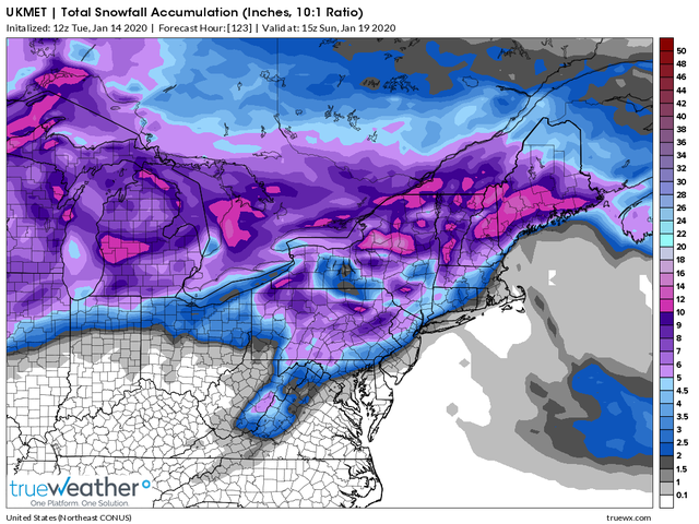
Here is todays UKMET for Saturday's snow. Trend has not been in our favor. The primary low is trending stronger/further N&W which means warm air floods us much sooner. 3-6" N&W of NYC but looking more like 1-3" for NYC Metro

Last edited by Frank_Wx on Tue Jan 14, 2020 1:22 pm; edited 1 time in total
_________________
_______________________________________________________________________________________________________
CLICK HERE to view NJ Strong Snowstorm Classifications
GreyBeard- Senior Enthusiast

- Posts : 725
Reputation : 34
Join date : 2014-02-12
Location : eastern nassau county
 Re: January 18th Winter Storm Looms
How bout now?
_________________
_______________________________________________________________________________________________________
CLICK HERE to view NJ Strong Snowstorm Classifications
 Re: January 18th Winter Storm Looms
Good to go!  But I am not liking it.
 But I am not liking it.
GreyBeard- Senior Enthusiast

- Posts : 725
Reputation : 34
Join date : 2014-02-12
Location : eastern nassau county
 Re: January 18th Winter Storm Looms
Frank and CP kind of beat me to it. Again with the MJO in such an amplified state in phase 6, our final soln favors a much more amplified wave, which unfort raises heights out ahead. Unfort the low will follow the path of least resistance. As you can clearly see in the images below(GFS then Euro) while there is a very potent arctic/polar HP parked to our North the delay in the timing of the system, combine with the lack of blocking in the Atlantic, the HP has little resistance to continue sliding east leaving a weakness on the western flank for which the primary LP, who's 500mb energy conts to trend stronger as does the resultant primary MSLP, can move/cut into. As Frank mentions with a stronger primary the further N&W it gets before any possibility of a transfer off the coast. The stronger it is and the further N&W it gets means the mid levels will warm faster. Dont get me wrong I think we all start as snow(including the coast), but I think overall my confidence is mod-high that a trend will persist that sees snow totals slowly drop as we get in tight. That said things that could still surprise us is the actual level of cold we are dealing with. Ive been fooled before with how stubborn the cold can be. Obv like Heehaw said N&W has the best chance to hold on the longest. Not 100% sold yet but getting there.


_________________
"In weather and in life, there's no winning and losing; there's only winning and learning."
WINTER 2012/2013 TOTALS 43.65"WINTER 2017/2018 TOTALS 62.85" WINTER 2022/2023 TOTALS 4.9"
WINTER 2013/2014 TOTALS 64.85"WINTER 2018/2019 TOTALS 14.25" WINTER 2023/2024 TOTALS 13.1"
WINTER 2014/2015 TOTALS 71.20"WINTER 2019/2020 TOTALS 6.35"
WINTER 2015/2016 TOTALS 35.00"WINTER 2020/2021 TOTALS 37.75"
WINTER 2016/2017 TOTALS 42.25"WINTER 2021/2022 TOTALS 31.65"

sroc4- Admin

- Posts : 8354
Reputation : 302
Join date : 2013-01-07
Location : Wading River, LI
 Re: January 18th Winter Storm Looms
Guess I'm on an island still feeling pretty good about this. lol.  Probably because my expectations are pretty low to begin with: I've had just about 2" of snow so far this winter so anything over that will more than double my total. I'm holding onto what appears to be a pretty stubborn cold air mass Friday into Saturday. But I never trust these "changeover" events anyway, so who knows.

billg315- Advanced Forecaster - Mod

- Posts : 4483
Reputation : 185
Join date : 2015-01-24
Age : 50
Location : Flemington, NJ
 Re: January 18th Winter Storm Looms
I'm also guilty of being parochial about these things sometimes, and even that UKMET has me in 3-6" which is fine by me.

billg315- Advanced Forecaster - Mod

- Posts : 4483
Reputation : 185
Join date : 2015-01-24
Age : 50
Location : Flemington, NJ
 Re: January 18th Winter Storm Looms
sroc4 wrote:Frank and CP kind of beat me to it. Again with the MJO in such an amplified state in phase 6, our final soln favors a much more amplified wave, which unfort raises heights out ahead. Unfort the low will follow the path of least resistance. As you can clearly see in the images below(GFS then Euro) while there is a very potent arctic/polar HP parked to our North the delay in the timing of the system, combine with the lack of blocking in the Atlantic, the HP has little resistance to continue sliding east leaving a weakness on the western flank for which the primary LP, who's 500mb energy conts to trend stronger as does the resultant primary MSLP, can move/cut into. As Frank mentions with a stronger primary the further N&W it gets before any possibility of a transfer off the coast. The stronger it is and the further N&W it gets means the mid levels will warm faster. Dont get me wrong I think we all start as snow(including the coast), but I think overall my confidence is mod-high that a trend will persist that sees snow totals slowly drop as we get in tight. That said things that could still surprise us is the actual level of cold we are dealing with. Ive been fooled before with how stubborn the cold can be. Obv like Heehaw said N&W has the best chance to hold on the longest. Not 100% sold yet but getting there.
If it amps up anymore than what today's 12Z Euro had this will be a very minor event for all. But again, we have seen storms amp up too much before at this range. I would not throw towel in until at least Thursday 12Z with this. The storm preceding it can act as a 50/50 block and you can get better ridging around James Bay which can tame it down and suppress it a bit more. It just takes a little bit at the 500mb to make huge differences at the surface. Expectations for this storm were always tempered, but now more so.
heehaw453- Advanced Forecaster

- Posts : 3906
Reputation : 86
Join date : 2014-01-20
Location : Bedminster Township, PA Elevation 600' ASL
 Re: January 18th Winter Storm Looms
Trend not good for the coast and those N & W should be okay with this in what Frank is saying a 3-6" type snow.
Some things to consider -
One the models are usually to slow with a SWFE =South west flow event.
Two - we are in phase 6 of the MJO which is a torch phase but we are moving into phase 7 - if you told any amatuer that we'd be getting snow in this phase after showing them temp maps of this phase they'd think your nuts!
Three - the coast is never a good spot for these types of storms UNLESS we have a HP over SE CAN or this area.
Four - we need the precip to move in faster since we have a moderate strength but east sliding HP - IF it was Friday night into Saturday afternoon we'd be in very good shape.
Five - the cold air is a dense cold air mass not a marginal air mass like in December storms so it will be cold but the Jet Streak and push of warm SW air will eventually overcome the wintry precip as noted ad naseum here
Six - this is the beginning of a pattern change so we usually get transition storms when this happens especially going from the warm phase into a colder phase
Seven - the Primary will most likely wind up stronger due various reasons - MJO, CME, Synoptic set up
Eight - take whatever white gold you get and run with it - you get what you get and you dont get upset!!
_________________
Mugs
AKA:King: Snow Weenie
Self Proclaimed
WINTER 2014-15 : 55.12" +.02 for 6 coatings (avg. 35")
WINTER 2015-16 Total - 29.8" (Avg 35")
WINTER 2016-17 : 39.5" so far

amugs- Advanced Forecaster - Mod

- Posts : 15095
Reputation : 213
Join date : 2013-01-07
Age : 54
Location : Hillsdale,NJ
 Re: January 18th Winter Storm Looms
Mugs I forgot to mention it but you did, the maps Im looking at the LLJ is screaming in from the SW from 900mb-925-850mb levels on both GFS and euro as the precip moves in. I hate the LLJ. Me and the LLJ are not cool with each other. Last time me and the LLJ ran into one another it got ugly. This is what I looked like after our last encounter.
(disclaimer: thats not really me lol)

(disclaimer: thats not really me lol)

_________________
"In weather and in life, there's no winning and losing; there's only winning and learning."
WINTER 2012/2013 TOTALS 43.65"WINTER 2017/2018 TOTALS 62.85" WINTER 2022/2023 TOTALS 4.9"
WINTER 2013/2014 TOTALS 64.85"WINTER 2018/2019 TOTALS 14.25" WINTER 2023/2024 TOTALS 13.1"
WINTER 2014/2015 TOTALS 71.20"WINTER 2019/2020 TOTALS 6.35"
WINTER 2015/2016 TOTALS 35.00"WINTER 2020/2021 TOTALS 37.75"
WINTER 2016/2017 TOTALS 42.25"WINTER 2021/2022 TOTALS 31.65"

sroc4- Admin

- Posts : 8354
Reputation : 302
Join date : 2013-01-07
Location : Wading River, LI
 Re: January 18th Winter Storm Looms
sroc4 wrote:Mugs I forgot to mention it but you did, the maps Im looking at the LLJ is screaming in from the SW from 900mb-925-850mb levels on both GFS and euro as the precip moves in. I hate the LLJ. Me and the LLJ are not cool with each other. Last time me and the LLJ ran into one another it got ugly. This is what I looked like after our last encounter.
(disclaimer: thats not really me lol)
LOL, Doc, shnazolapalooza!! That's painful just looking at!
I'll be happy with 3 inches in this transition storm as long as no slop comes in.It's getting cold the next week so there will be a snowpack for a while.
Looks like Math23x7 is in a good spot again!

docstox12- Wx Statistician Guru

- Posts : 8530
Reputation : 222
Join date : 2013-01-07
Age : 73
Location : Monroe NY
 Re: January 18th Winter Storm Looms
sroc4 wrote:Mugs I forgot to mention it but you did, the maps Im looking at the LLJ is screaming in from the SW from 900mb-925-850mb levels on both GFS and euro as the precip moves in. I hate the LLJ. Me and the LLJ are not cool with each other. Last time me and the LLJ ran into one another it got ugly. This is what I looked like after our last encounter.
(disclaimer: thats not really me lol)
That a boy Doc kick his arse !!!
_________________
Mugs
AKA:King: Snow Weenie
Self Proclaimed
WINTER 2014-15 : 55.12" +.02 for 6 coatings (avg. 35")
WINTER 2015-16 Total - 29.8" (Avg 35")
WINTER 2016-17 : 39.5" so far

amugs- Advanced Forecaster - Mod

- Posts : 15095
Reputation : 213
Join date : 2013-01-07
Age : 54
Location : Hillsdale,NJ
 Re: January 18th Winter Storm Looms
At least you are smiling  What did the LLJ look like after after that encounter
  One would think the LLJ would be throwing a lot of low blows, below the belt as they say, or did he do that and then gave you a knee to the shnoz while you were doubled over?
The first rule of Fight Club is: You do not talk about Fight Club. The second rule of Fight Club is: You do not talk about Fight Club. Third rule of Fight Club: Someone yells "Stop!", goes limp, taps out, the fight is over. Fourth rule: Only two guys to a fight.
The first rule of Fight Club is: You do not talk about Fight Club. The second rule of Fight Club is: You do not talk about Fight Club. Third rule of Fight Club: Someone yells "Stop!", goes limp, taps out, the fight is over. Fourth rule: Only two guys to a fight.
GreyBeard- Senior Enthusiast

- Posts : 725
Reputation : 34
Join date : 2014-02-12
Location : eastern nassau county
 Re: January 18th Winter Storm Looms
Well I'm not surprised coast gets skunked again but 5his time I'm actually okay with it I'd prefer it be dry and cloudy actually. I have my father in law headed home to CA and we are headed to CT for the long weekend. People can't drive in one inches so unless it's go be worth my while like 6 inches plus I'd prefer to get nothing.

jmanley32- Senior Enthusiast

- Posts : 20535
Reputation : 108
Join date : 2013-12-12
Age : 43
Location : Yonkers, NY
 Re: January 18th Winter Storm Looms
In CNJ here and if I miss out on this one I will have to hope for the best with the upcoming pattern. We are still over 3 days out so we do have time for mother nature to smile upon the snow geese
phil155- Pro Enthusiast

- Posts : 483
Reputation : 4
Join date : 2019-12-16
 Re: January 18th Winter Storm Looms
Frank, I have been seeing your images all along on my iPhone. Today, yesterday, etc.

dkodgis- Senior Enthusiast

- Posts : 2560
Reputation : 98
Join date : 2013-12-29
 Re: January 18th Winter Storm Looms
3 days+ out now and I'd say models are telling us that storm moves north and is bit more amped. This does two things: erodes the cold air mass more quickly and allows forcing to be much further west. We won't get the really good thump as modeled.
This could still trend either way, but it's not like models pulled the rug out from under us 2 days out. So if trends the other way that'll be great.
Thoughts as of today
2-4" NW of 95 (lots more 2's & 3's)
1-2" Along and near 95
C-1" SE of 95
This could still trend either way, but it's not like models pulled the rug out from under us 2 days out. So if trends the other way that'll be great.
Thoughts as of today
2-4" NW of 95 (lots more 2's & 3's)
1-2" Along and near 95
C-1" SE of 95
heehaw453- Advanced Forecaster

- Posts : 3906
Reputation : 86
Join date : 2014-01-20
Location : Bedminster Township, PA Elevation 600' ASL
 Re: January 18th Winter Storm Looms
sroc4 wrote:Mugs I forgot to mention it but you did, the maps Im looking at the LLJ is screaming in from the SW from 900mb-925-850mb levels on both GFS and euro as the precip moves in. I hate the LLJ. Me and the LLJ are not cool with each other. Last time me and the LLJ ran into one another it got ugly. This is what I looked like after our last encounter.
(disclaimer: thats not really me lol)
This is great
heehaw453 wrote:3 days+ out now and I'd say models are telling us that storm moves north and is bit more amped. This does two things: erodes the cold air mass more quickly and allows forcing to be much further west. We won't get the really good thump as modeled.
This could still trend either way, but it's not like models pulled the rug out from under us 2 days out. So if trends the other way that'll be great.
Thoughts as of today
2-4" NW of 95 (lots more 2's & 3's)
1-2" Along and near 95
C-1" SE of 95
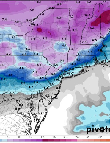
This is where my head is at this morning. Potential some places N&W of NYC see >4 inches still but with how trends are going unlikely. Here is last nights EURO and you can see the sharp gradient.

_________________
_______________________________________________________________________________________________________
CLICK HERE to view NJ Strong Snowstorm Classifications
 Re: January 18th Winter Storm Looms
heehaw453 wrote:3 days+ out now and I'd say models are telling us that storm moves north and is bit more amped. This does two things: erodes the cold air mass more quickly and allows forcing to be much further west. We won't get the really good thump as modeled.
This could still trend either way, but it's not like models pulled the rug out from under us 2 days out. So if trends the other way that'll be great.
Thoughts as of today
2-4" NW of 95 (lots more 2's & 3's)
1-2" Along and near 95
C-1" SE of 95
I would largely agree with this. Only marginally (insignificantly) different than my thoughts. I still think 3-6” N&W and west of I-95. 1-2 maybe squeeze out 3” in spots along 95. The coast won’t see much no matter how this develops.

billg315- Advanced Forecaster - Mod

- Posts : 4483
Reputation : 185
Join date : 2015-01-24
Age : 50
Location : Flemington, NJ
 Re: January 18th Winter Storm Looms
Three - the coast is never a good spot for these types of storms UNLESS we have a HP over SE CAN or this area
SWFE are better for inland areas - seems to be a pattern here these last coupe of months. In the macro scale of this board what a gradient so far this far this winter of about 50-75 miles away from the coast.
Anyway any snow is good snow.
SWFE are better for inland areas - seems to be a pattern here these last coupe of months. In the macro scale of this board what a gradient so far this far this winter of about 50-75 miles away from the coast.
Anyway any snow is good snow.
_________________
Mugs
AKA:King: Snow Weenie
Self Proclaimed
WINTER 2014-15 : 55.12" +.02 for 6 coatings (avg. 35")
WINTER 2015-16 Total - 29.8" (Avg 35")
WINTER 2016-17 : 39.5" so far

amugs- Advanced Forecaster - Mod

- Posts : 15095
Reputation : 213
Join date : 2013-01-07
Age : 54
Location : Hillsdale,NJ
 Re: January 18th Winter Storm Looms
eeewew that picture is disgusting....guess we are not in this game this weel..hope we get some new chance soon

weatherwatchermom- Senior Enthusiast

- Posts : 3793
Reputation : 78
Join date : 2014-11-25
Location : Hazlet Township, NJ
 Re: January 18th Winter Storm Looms
This is one heck of frontgensis that will be a thunderstorm of snow as it moves through IF the NAM is correct in the map below. Tremendous lift in these darker purple colors.
IF again IF this is correct this can be a fast hard thump before the screaming LLJ sends in the Warm Miser
N&W of I 95 sees a good 2-4" NW NJ, LHV (Rockland , Northern Westchester Orange) gets the 3-6" snow as has been echoed. City/Coast 1-2"ish
If it come sin faster which is possible by a couple of hours then the snow totals would go up by about 1"
Mesoscale models are starting to come into play and interesting to see how they handle some of teh subtle but could be differences in this storm.
The warm tongue could make a n interesting snow dispersion of snowing in NNJ and mix into Central PA.

_________________
Mugs
AKA:King: Snow Weenie
Self Proclaimed
WINTER 2014-15 : 55.12" +.02 for 6 coatings (avg. 35")
WINTER 2015-16 Total - 29.8" (Avg 35")
WINTER 2016-17 : 39.5" so far

amugs- Advanced Forecaster - Mod

- Posts : 15095
Reputation : 213
Join date : 2013-01-07
Age : 54
Location : Hillsdale,NJ
 Re: January 18th Winter Storm Looms
NAM still a bit far out for its best range no?

bobjohnsonforthehall- Posts : 311
Reputation : 19
Join date : 2016-10-02
Location : Flemington NJ
 Re: January 18th Winter Storm Looms
For what its worth the 12z GFS is holding consistent as it has been on the last several runs with a pretty prolonged front-end snow of generally 3-5" pretty much every where north and west of the immediate NYC area. Actually not a whole lot different from the NAM except the NAM throws in an area of sleet in the middle of the snow for some areas in Central NJ/Eastern PA.

billg315- Advanced Forecaster - Mod

- Posts : 4483
Reputation : 185
Join date : 2015-01-24
Age : 50
Location : Flemington, NJ
 Re: January 18th Winter Storm Looms
Euro a bit weaker this run. Shore still just an inch or so city maybe 1-2. Draw a line from Trenton to NYC and north of that line is 3-5.

bobjohnsonforthehall- Posts : 311
Reputation : 19
Join date : 2016-10-02
Location : Flemington NJ
Page 2 of 6 •  1, 2, 3, 4, 5, 6
Permissions in this forum:
You cannot reply to topics in this forum|
|
|

 Home
Home