Hurricane Season 2020-Active Season-
+31
brownie
Dis2cruise
Joe Snow
sabamfa
Nyi1058
gigs68
DAYBLAZER
Sanchize06
docstox12
essexcountypete
larryrock72
weatherwatchermom
aiannone
hyde345
frank 638
skinsfan1177
oldtimer
phil155
Dunnzoo
Grselig
nutleyblizzard
GreyBeard
SoulSingMG
sroc4
rb924119
mwilli
dkodgis
Frank_Wx
amugs
Quietace
jmanley32
35 posters
Page 2 of 25
Page 2 of 25 •  1, 2, 3 ... 13 ... 25
 Re: Hurricane Season 2020-Active Season-
Wagons WEST says the GFS


amugs- Advanced Forecaster - Mod

- Posts : 15095
Join date : 2013-01-07
 Re: Hurricane Season 2020-Active Season-
mugs I can never see your images, is anyone else having this issue? It appears the tropical system wants to head directly into our area on GFS but putters out right b4 landfall as a weak TS or subtropical storm. What does Euro show? On GFS the 18z shows al lthe heaviest rain offshore, but very close. Will be a interesting next several days of tracking. I guess everyone is out enjoying the weather. Hope you are all staying safe out there.
jmanley32- Senior Enthusiast

- Posts : 20535
Join date : 2013-12-12
 Re: Hurricane Season 2020-Active Season-
I’m officially celebrating now haha Ryan, I’m still confused as to what you’re saying, but if you feel it would be flogging a dead horse, we can move on haha it’s amazing what a break in the shear can do for a tropical system. Jman, I haven’t followed the evolution of this system closely, as I was mainly concerned with its initial development given my previous and long-standing ideas. That said, overwhelming consensus is for this to remain a fish storm. It’s certainly a close call, but without further analysis I don’t want to say anything definitive haha
rb924119- Meteorologist

- Posts : 6928
Reputation : 194
Join date : 2013-02-06
Age : 32
Location : Greentown, Pa

SoulSingMG- Senior Enthusiast

- Posts : 2853
Reputation : 74
Join date : 2013-12-11
Location : Long Island City, NY
 Re: Hurricane Season 2020-Active Season-
A swing and a miss

dkodgis- Senior Enthusiast

- Posts : 2560
Reputation : 98
Join date : 2013-12-29
 Re: Hurricane Season 2020-Active Season-
Yeah this morning's cone drastically shifted more east. So are we still going to see all this rain or not because I thought it was a interaction of the 2.

jmanley32- Senior Enthusiast

- Posts : 20535
Reputation : 108
Join date : 2013-12-12
Age : 43
Location : Yonkers, NY
 Re: Hurricane Season 2020-Active Season-
I postulated last week with a couple coworkers that I wonder if we don’t quiet down substantially during the second-half, and climatological peak, of the season. We seem to be experiencing periods of ~3-5 months of alternating large-scale forcing in the equatorial Pacific since last year (largely enhancing particular phases of the MJO, 8-3/4-7 in alternate fashion), and this period of more favorable alignment began back in the beginning of April, even if we only recently realized the tropical potential. Therefore, if we extrapolated this out, July-August should show a reversal/downward trend in tropical activity, *assuming this observation would hold*. I have not looked seriously into this yet, but it’s an interesting observation/out loud thought, at least to me lol
rb924119- Meteorologist

- Posts : 6928
Reputation : 194
Join date : 2013-02-06
Age : 32
Location : Greentown, Pa
 Re: Hurricane Season 2020-Active Season-
NOAA bullish on a more active season. 60% chance for an above normal season, according to them.
https://www.noaa.gov/media-release/busy-atlantic-hurricane-season-predicted-for-2020
https://www.noaa.gov/media-release/busy-atlantic-hurricane-season-predicted-for-2020
GreyBeard- Senior Enthusiast

- Posts : 725
Reputation : 34
Join date : 2014-02-12
Location : eastern nassau county
 Re: Hurricane Season 2020-Active Season-
Fantasyland GFS has a hurricane anywhere from Florida to central Gulf around day 13-16. Ways off but fits the time frame RB talking about, we always see a lull in July/August and see all our storms late august to end October.

jmanley32- Senior Enthusiast

- Posts : 20535
Reputation : 108
Join date : 2013-12-12
Age : 43
Location : Yonkers, NY
 Re: Hurricane Season 2020-Active Season-
Just looked the GFS model(long term)showing tropical storm/hurricane at 981-984 low pressure for 6/7-6/8 hitting Louisana,Orleans,I know this is preliminary and things could change(I hope)but keep a eye on this.....
mwilli- Posts : 132
Reputation : 3
Join date : 2019-02-11

nutleyblizzard- Senior Enthusiast

- Posts : 1954
Reputation : 41
Join date : 2014-01-30
Age : 58
Location : Nutley, new jersey
 Re: Hurricane Season 2020-Active Season-
We got the Gulf on percolation mode!!
https://www.nhc.noaa.gov/xgtwo/two_atl_2d0.png


FYI
Tropical Weather Outlook
NWS National Hurricane Center Miami FL
800 AM EDT Mon Jun 1 2020
For the North Atlantic...Caribbean Sea and the Gulf of Mexico:
1. A large area of disturbed weather, associated with the remnants of
eastern Pacific Tropical Storm Amanda, is located over the Yucatan
peninsula of Mexico. This disturbance is forecast to move
northwestward over the southeastern portion of the Bay of Campeche
later today or tonight where environmental conditions are expected
to be conducive to support development, and a new tropical
depression is likely to form within within the next day or so. The
system is then forecast to drift west or west-southwest over the
southern Bay of Campeche through the middle of the week. Interests
along the coast of the Bay of Campeche should monitor the progress
of this disturbance. Regardless of tropical cyclone formation,
heavy rainfall is likely to continue over portions of southern
Mexico, Guatemala, El Salvador, Belize, and western Honduras during
the next few days. For additional information on the rainfall
threat, see products from your national meteorological service.
* Formation chance through 48 hours...high...80 percent.
* Formation chance through 5 days...high...80 percent.
Today marks the first day of the Atlantic hurricane season, which
will run until November 30. Long-term averages for the number of
named storms, hurricanes, and major hurricanes are 12, 6, and 3,
respectively.
The list of names for 2020 is as follows:
Name Pronunciation Name Pronunciation
-------------------------------------------------------------
Arthur AR-thur Laura LOOR-ruh
Bertha BUR-thuh Marco MAR-koe
Cristobal krees-TOH-bahl Nana NA-na
Dolly DAH-lee Omar OH-mar
Edouard ed-DWARD Paulette pawl-LET
Fay fay Rene re-NAY
Gonzalo gohn-SAH-loh Sally SAL-ee
Hanna HAN-uh Teddy TEHD-ee
Isaias ees-ah-EE-ahs Vicky VIH-kee
Josephine JOH-seh-feen Wilfred WILL-fred
Kyle KY-ull
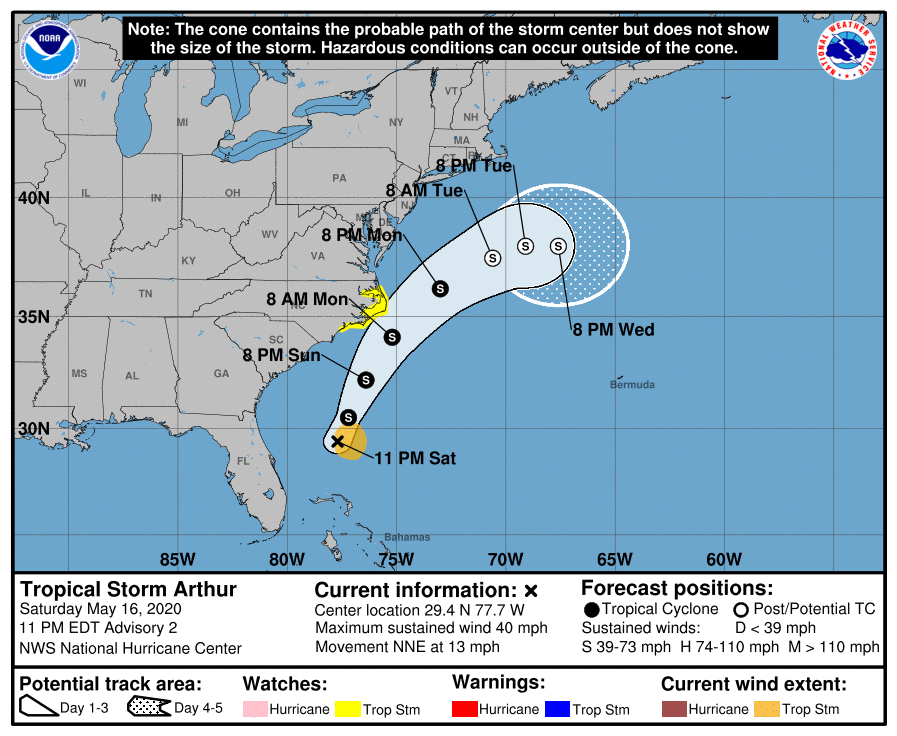
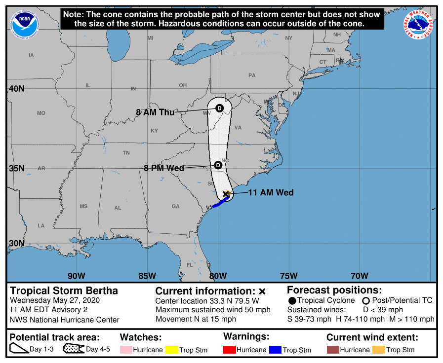
Two tropical storms, Arthur and Bertha, already formed this year in
May. The next named storm that develops this season will be
Cristobal.
This product, the Tropical Weather Outlook, briefly describes
significant areas of disturbed weather and their potential for
tropical cyclone formation during the next five days. The issuance
times of this product are 2 AM, 8 AM, 2 AM, and 8 PM EDT. After the
change to standard time in November, the issuance times are 1 AM,
7 AM, 1 PM, and 7 PM EST.
https://www.nhc.noaa.gov/xgtwo/two_atl_2d0.png


FYI
Tropical Weather Outlook
NWS National Hurricane Center Miami FL
800 AM EDT Mon Jun 1 2020
For the North Atlantic...Caribbean Sea and the Gulf of Mexico:
1. A large area of disturbed weather, associated with the remnants of
eastern Pacific Tropical Storm Amanda, is located over the Yucatan
peninsula of Mexico. This disturbance is forecast to move
northwestward over the southeastern portion of the Bay of Campeche
later today or tonight where environmental conditions are expected
to be conducive to support development, and a new tropical
depression is likely to form within within the next day or so. The
system is then forecast to drift west or west-southwest over the
southern Bay of Campeche through the middle of the week. Interests
along the coast of the Bay of Campeche should monitor the progress
of this disturbance. Regardless of tropical cyclone formation,
heavy rainfall is likely to continue over portions of southern
Mexico, Guatemala, El Salvador, Belize, and western Honduras during
the next few days. For additional information on the rainfall
threat, see products from your national meteorological service.
* Formation chance through 48 hours...high...80 percent.
* Formation chance through 5 days...high...80 percent.
Today marks the first day of the Atlantic hurricane season, which
will run until November 30. Long-term averages for the number of
named storms, hurricanes, and major hurricanes are 12, 6, and 3,
respectively.
The list of names for 2020 is as follows:
Name Pronunciation Name Pronunciation
-------------------------------------------------------------
Arthur AR-thur Laura LOOR-ruh
Bertha BUR-thuh Marco MAR-koe
Cristobal krees-TOH-bahl Nana NA-na
Dolly DAH-lee Omar OH-mar
Edouard ed-DWARD Paulette pawl-LET
Fay fay Rene re-NAY
Gonzalo gohn-SAH-loh Sally SAL-ee
Hanna HAN-uh Teddy TEHD-ee
Isaias ees-ah-EE-ahs Vicky VIH-kee
Josephine JOH-seh-feen Wilfred WILL-fred
Kyle KY-ull
Two tropical storms, Arthur and Bertha, already formed this year in
May. The next named storm that develops this season will be
Cristobal.
This product, the Tropical Weather Outlook, briefly describes
significant areas of disturbed weather and their potential for
tropical cyclone formation during the next five days. The issuance
times of this product are 2 AM, 8 AM, 2 AM, and 8 PM EDT. After the
change to standard time in November, the issuance times are 1 AM,
7 AM, 1 PM, and 7 PM EST.
_________________
Mugs
AKA:King: Snow Weenie
Self Proclaimed
WINTER 2014-15 : 55.12" +.02 for 6 coatings (avg. 35")
WINTER 2015-16 Total - 29.8" (Avg 35")
WINTER 2016-17 : 39.5" so far

amugs- Advanced Forecaster - Mod

- Posts : 15095
Reputation : 213
Join date : 2013-01-07
Age : 54
Location : Hillsdale,NJ
 Re: Hurricane Season 2020-Active Season-


_________________
Mugs
AKA:King: Snow Weenie
Self Proclaimed
WINTER 2014-15 : 55.12" +.02 for 6 coatings (avg. 35")
WINTER 2015-16 Total - 29.8" (Avg 35")
WINTER 2016-17 : 39.5" so far

amugs- Advanced Forecaster - Mod

- Posts : 15095
Reputation : 213
Join date : 2013-01-07
Age : 54
Location : Hillsdale,NJ
 Re: Hurricane Season 2020-Active Season-
Okayyy... I mist have missed this what in the actual $$$k?? A tropical system regaining strength in canada? What else does 2020 bring? Sharknados next?amugs wrote:

jmanley32- Senior Enthusiast

- Posts : 20535
Reputation : 108
Join date : 2013-12-12
Age : 43
Location : Yonkers, NY
 Re: Hurricane Season 2020-Active Season-
jmanley32 wrote:Okayyy... I mist have missed this what in the actual $$$k?? A tropical system regaining strength in canada? What else does 2020 bring? Sharknados next?amugs wrote:
Over the cold Great Lakes?????

Grselig- Senior Enthusiast

- Posts : 1408
Reputation : 140
Join date : 2013-03-04
Age : 54
Location : Wayne NJ
 Re: Hurricane Season 2020-Active Season-
I predict a hurricane the last week of August just as my vacation in Wildwood starts 
_________________
_______________________________________________________________________________________________________
CLICK HERE to view NJ Strong Snowstorm Classifications
 Re: Hurricane Season 2020-Active Season-
Frank_Wx wrote:I predict a hurricane the last week of August just as my vacation in Wildwood starts
Better not, I'm in Seaside Park from 8/14 to the end of the month...
_________________
Janet
Snowfall winter of 2023-2024 17.5"
Snowfall winter of 2022-2023 6.0"
Snowfall winter of 2021-2022 17.6" 1" sleet 2/25/22
Snowfall winter of 2020-2021 51.1"
Snowfall winter of 2019-2020 8.5"
Snowfall winter of 2018-2019 25.1"
Snowfall winter of 2017-2018 51.9"
Snowfall winter of 2016-2017 45.6"
Snowfall winter of 2015-2016 29.5"
Snowfall winter of 2014-2015 50.55"
Snowfall winter of 2013-2014 66.5"
Dunnzoo- Senior Enthusiast - Mod

- Posts : 4905
Reputation : 68
Join date : 2013-01-11
Age : 62
Location : Westwood, NJ
 Re: Hurricane Season 2020-Active Season-
Looks like GFS, euro and CMC have something weak developing right along the coast emerging off the carolinas and riding the coast into NYC starting around hour 90. Is that something tropical or just a LP system? Yep Frank if you have a vacation planned away from here something exciting will surely happen while you are away.

jmanley32- Senior Enthusiast

- Posts : 20535
Reputation : 108
Join date : 2013-12-12
Age : 43
Location : Yonkers, NY

jmanley32- Senior Enthusiast

- Posts : 20535
Reputation : 108
Join date : 2013-12-12
Age : 43
Location : Yonkers, NY
 Re: Hurricane Season 2020-Active Season-
Currently projected the system above will be off NJ coast and run into LI or nearby as a weak 1004mb TS (approx. winds 40-45mph) on friday night, flooding rains being the most risk. could see some wind advisory to HWW criteria gusts if the windfield is placed right (being on the left side is usually the calmer side in terms of winds. And this is IF we actually do see development, if the low stays just inland will likely just be a rainmaker, needless to say sat is a wash.

jmanley32- Senior Enthusiast

- Posts : 20535
Reputation : 108
Join date : 2013-12-12
Age : 43
Location : Yonkers, NY
 Re: Hurricane Season 2020-Active Season-
EURO says hello

Winds Meh but for teh coast its windy

Gusts

GFS
Gusts
https://images.weatherbell.com/model/gfs-deterministic/ma/gust_mph/1594144800/1594382400-eyu4NYBLzl8.png
Keeps it off the coast


Winds Meh but for teh coast its windy

Gusts

GFS
Gusts
https://images.weatherbell.com/model/gfs-deterministic/ma/gust_mph/1594144800/1594382400-eyu4NYBLzl8.png
Keeps it off the coast

_________________
Mugs
AKA:King: Snow Weenie
Self Proclaimed
WINTER 2014-15 : 55.12" +.02 for 6 coatings (avg. 35")
WINTER 2015-16 Total - 29.8" (Avg 35")
WINTER 2016-17 : 39.5" so far

amugs- Advanced Forecaster - Mod

- Posts : 15095
Reputation : 213
Join date : 2013-01-07
Age : 54
Location : Hillsdale,NJ
 Re: Hurricane Season 2020-Active Season-
I posted an update in the other thread on accident. Here it is!
I am keeping a watchful eye on a potential coastal storm that would impact us this Friday.
The upper level pattern is quite fascinating. A persistent western ridge - temps ranging between 100 and 115 degrees across the Southwest - coupled with a secondary ridge located over Prince Edward Island in Canada - may force a sub-tropical low pressure to track directly over our area.

The jet streak directly north of our region provides a nearly vertical path for any storm to follow. There's also lower heights moving through the Midwest that will attempt to capture the system off the coast. Very interesting!
Models of course are all over. NAM tracks the low west of NJ - heavy rain for all - while GFS is off the coast and more of a glancing blow. Others models are in-between. Curious to give this another day of model runs before drawing a conclusion.
I am keeping a watchful eye on a potential coastal storm that would impact us this Friday.
The upper level pattern is quite fascinating. A persistent western ridge - temps ranging between 100 and 115 degrees across the Southwest - coupled with a secondary ridge located over Prince Edward Island in Canada - may force a sub-tropical low pressure to track directly over our area.

The jet streak directly north of our region provides a nearly vertical path for any storm to follow. There's also lower heights moving through the Midwest that will attempt to capture the system off the coast. Very interesting!
Models of course are all over. NAM tracks the low west of NJ - heavy rain for all - while GFS is off the coast and more of a glancing blow. Others models are in-between. Curious to give this another day of model runs before drawing a conclusion.
_________________
_______________________________________________________________________________________________________
CLICK HERE to view NJ Strong Snowstorm Classifications
 Re: Hurricane Season 2020-Active Season-
amugs wrote:EURO says hello
Winds Meh but for teh coast its windy
Gusts
GFS
Gusts
https://images.weatherbell.com/model/gfs-deterministic/ma/gust_mph/1594144800/1594382400-eyu4NYBLzl8.png
Keeps it off the coast
The rain rates do not look impressive on the EURO. You can tell there is not a lot of juice with this thing.
_________________
_______________________________________________________________________________________________________
CLICK HERE to view NJ Strong Snowstorm Classifications
 Re: Hurricane Season 2020-Active Season-
GEFS


_________________
_______________________________________________________________________________________________________
CLICK HERE to view NJ Strong Snowstorm Classifications
 Re: Hurricane Season 2020-Active Season-
CSU updated call for hcane season battinndown the hatches they are saying. Latest SST anomaly maps for Aug through Oct show an increasing warm MDR (main development region) with cooler water over the top producing analog years of 2005 that stand out. This SST set up will allow for Cape Verde storms to make the long haul from Africa to the USA if wanted along with a persistent WAR more west which channels the storms to the Eastern Seaboard. Oh and the gulf is AN as well. Going to be a LOOONNNGG HCANE season for us Americans.
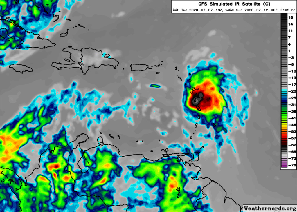
GFS has a trop cyclone Sunday in the Carribean.
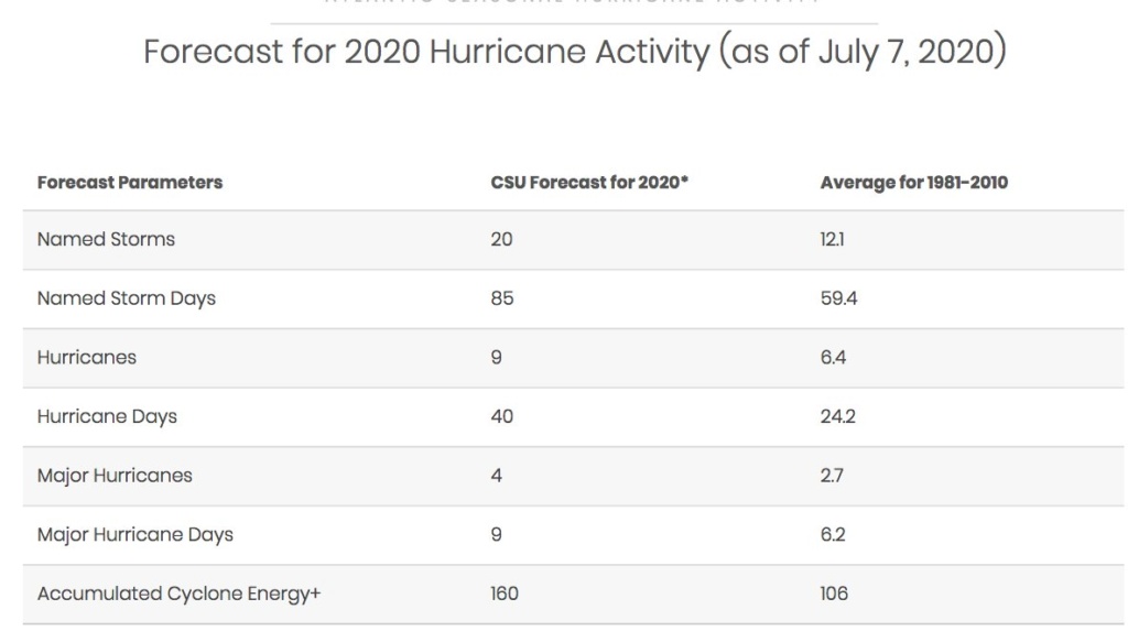

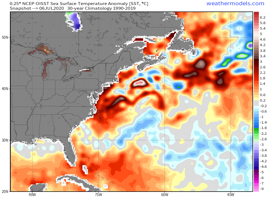
GFS has a trop cyclone Sunday in the Carribean.


_________________
Mugs
AKA:King: Snow Weenie
Self Proclaimed
WINTER 2014-15 : 55.12" +.02 for 6 coatings (avg. 35")
WINTER 2015-16 Total - 29.8" (Avg 35")
WINTER 2016-17 : 39.5" so far

amugs- Advanced Forecaster - Mod

- Posts : 15095
Reputation : 213
Join date : 2013-01-07
Age : 54
Location : Hillsdale,NJ
 Re: Hurricane Season 2020-Active Season-
_________________
Mugs
AKA:King: Snow Weenie
Self Proclaimed
WINTER 2014-15 : 55.12" +.02 for 6 coatings (avg. 35")
WINTER 2015-16 Total - 29.8" (Avg 35")
WINTER 2016-17 : 39.5" so far

amugs- Advanced Forecaster - Mod

- Posts : 15095
Reputation : 213
Join date : 2013-01-07
Age : 54
Location : Hillsdale,NJ
 Re: Hurricane Season 2020-Active Season-
If this were late August this most likely be a trop storm due to the environment and set up


_________________
Mugs
AKA:King: Snow Weenie
Self Proclaimed
WINTER 2014-15 : 55.12" +.02 for 6 coatings (avg. 35")
WINTER 2015-16 Total - 29.8" (Avg 35")
WINTER 2016-17 : 39.5" so far

amugs- Advanced Forecaster - Mod

- Posts : 15095
Reputation : 213
Join date : 2013-01-07
Age : 54
Location : Hillsdale,NJ
Page 2 of 25 •  1, 2, 3 ... 13 ... 25
Page 2 of 25
Permissions in this forum:
You cannot reply to topics in this forum|
|
|

 Home
Home