April 2020 Observations and Discussion
+23
SkiSeadooJoe
crippo84
CPcantmeasuresnow
1190ftalt
Vinnydula
phil155
aiannone
Zhukov1945
skinsfan1177
weatherwatchermom
Frank_Wx
Sanchize06
SENJsnowman
brownie
Dunnzoo
essexcountypete
docstox12
jmanley32
amugs
frank 638
dkodgis
SoulSingMG
billg315
27 posters
Page 4 of 8 •  1, 2, 3, 4, 5, 6, 7, 8
 Re: April 2020 Observations and Discussion
Wind is howling, trees and power lines down, 1.62" of rain so far. And it is going to be worse later when the front comes through. Hang on everyone!
Dunnzoo- Senior Enthusiast - Mod

- Posts : 4905
Join date : 2013-01-11
 Re: April 2020 Observations and Discussion
TORNADO WATCH OUTLINE UPDATE FOR WT 119
NWS STORM PREDICTION CENTER NORMAN OK
1130 AM EDT MON APR 13 2020
TORNADO WATCH 119 IS IN EFFECT UNTIL 600 PM EDT FOR THE
FOLLOWING LOCATIONS
NJC001-005-007-009-011-015-019-021-023-025-027-029-033-035-037-
041-132200-
/O.NEW.KWNS.TO.A.0119.200413T1530Z-200413T2200Z/
NJ
. NEW JERSEY COUNTIES INCLUDED ARE
ATLANTIC BURLINGTON CAMDEN
CAPE MAY CUMBERLAND GLOUCESTER
HUNTERDON MERCER MIDDLESEX
MONMOUTH MORRIS OCEAN
SALEM SOMERSET SUSSEX
WARREN
$$
PA
. PENNSYLVANIA COUNTIES INCLUDED ARE
ADAMS BEDFORD BERKS
BLAIR BUCKS CAMBRIA
CARBON CENTRE CHESTER
CLINTON COLUMBIA CUMBERLAND
DAUPHIN DELAWARE FRANKLIN
FULTON HUNTINGDON JUNIATA
LANCASTER LEBANON LEHIGH
LUZERNE LYCOMING MIFFLIN
MONROE MONTGOMERY MONTOUR
NORTHAMPTON NORTHUMBERLAND PERRY
PHILADELPHIA SCHUYLKILL SNYDER
SOMERSET SULLIVAN UNION
YORK
The winds are picking up 50K wout power in NJ - buddy at PSEG is expecting that number to double or even triple when the brunt comes through especially along the coastal regions.
Hold on peeps the show is about to starting
amugs- Advanced Forecaster - Mod

- Posts : 15095
Join date : 2013-01-07
 Re: April 2020 Observations and Discussion
Nothing crazy going on here. It's a little windy and rain has stoped

Vinnydula- Pro Enthusiast

- Posts : 778
Reputation : 8
Join date : 2013-12-12
Location : Dobbs ferry
 Re: April 2020 Observations and Discussion
Wind has come down a bit here (North Central NJ) but once the storms and or heavy rain begins again I have little doubt we will see them pick up in a big way
phil155- Pro Enthusiast

- Posts : 483
Reputation : 4
Join date : 2019-12-16
 Re: April 2020 Observations and Discussion
Is that it? Winds died off almost completely. 6 hrs early? Or is the worst coming as they just upped top gusts.

jmanley32- Senior Enthusiast

- Posts : 20535
Reputation : 108
Join date : 2013-12-12
Age : 43
Location : Yonkers, NY
 Re: April 2020 Observations and Discussion
I was just up there you kidding? Many power outages and the wind was rippingVinnydula wrote:Nothing crazy going on here. It's a little windy and rain has stoped
It's a sudden lull now.

jmanley32- Senior Enthusiast

- Posts : 20535
Reputation : 108
Join date : 2013-12-12
Age : 43
Location : Yonkers, NY
 Re: April 2020 Observations and Discussion
yeah thinking the most intense winds come a bit later few hrs May be like 2 or 3.phil155 wrote:Wind has come down a bit here (North Central NJ) but once the storms and or heavy rain begins again I have little doubt we will see them pick up in a big way

jmanley32- Senior Enthusiast

- Posts : 20535
Reputation : 108
Join date : 2013-12-12
Age : 43
Location : Yonkers, NY

SoulSingMG- Senior Enthusiast

- Posts : 2853
Reputation : 74
Join date : 2013-12-11
Location : Long Island City, NY

billg315- Advanced Forecaster - Mod

- Posts : 4483
Reputation : 185
Join date : 2015-01-24
Age : 50
Location : Flemington, NJ
 Re: April 2020 Observations and Discussion
Will the tornado watch be extended in the NYC area, its very close just to the other side of the hudson. Yeah its dead calm now, nothing like this morning, coned edison and police all over. My car almost got smashed by the top of a metal recycling can in a parking lot that gets really good gusts as its elevated and wide open. We will have to see what happens. I saw a car crushed by a tree and abour 11,000 without power right now. I expect that may go way up with the back end coming through.

jmanley32- Senior Enthusiast

- Posts : 20535
Reputation : 108
Join date : 2013-12-12
Age : 43
Location : Yonkers, NY

jmanley32- Senior Enthusiast

- Posts : 20535
Reputation : 108
Join date : 2013-12-12
Age : 43
Location : Yonkers, NY
 Re: April 2020 Observations and Discussion
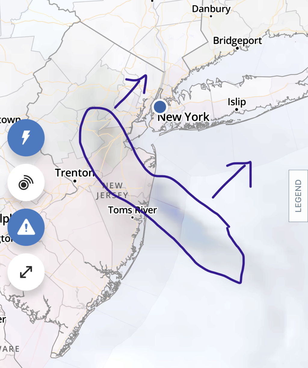
It’s a satellite image of an area of clearing the NWS pointed out as well. This “dry slot” moving to the northeast had reports of 70+ mph winds in DE & SNJ; a 76 mph wind was just recorded at a buoy just south of Islip (now under this clearing).

SoulSingMG- Senior Enthusiast

- Posts : 2853
Reputation : 74
Join date : 2013-12-11
Location : Long Island City, NY
 Re: April 2020 Observations and Discussion
Jman I only seen that winds got up to 23mph here. Maybe I'm missing something

Vinnydula- Pro Enthusiast

- Posts : 778
Reputation : 8
Join date : 2013-12-12
Location : Dobbs ferry
 Re: April 2020 Observations and Discussion
Well if its that far north then it didnt effect us here for sure, why would a clearing allow more wind? I thought you neede convection to bring the winds down. So that is the end of it after tha clearing or are you saying its after that clearing that we see stronger winds?SoulSingMG wrote:
It’s a satellite image of an area of clearing the NWS pointed out as well. This “dry slot” moving to the northeast had reports of 70+ mph winds in DE & SNJ; a 76 mph wind was just recorded at a buoy just south of Islip (now under this clearing).

jmanley32- Senior Enthusiast

- Posts : 20535
Reputation : 108
Join date : 2013-12-12
Age : 43
Location : Yonkers, NY
 Re: April 2020 Observations and Discussion
And just like that its howling again, lets see what happens if one of those severe lines gets over here.

jmanley32- Senior Enthusiast

- Posts : 20535
Reputation : 108
Join date : 2013-12-12
Age : 43
Location : Yonkers, NY
 Re: April 2020 Observations and Discussion
jmanley32 wrote:Well if its that far north then it didnt effect us here for sure, why would a clearing allow more wind? I thought you neede convection to bring the winds down. So that is the end of it after tha clearing or are you saying its after that clearing that we see stronger winds?SoulSingMG wrote:
It’s a satellite image of an area of clearing the NWS pointed out as well. This “dry slot” moving to the northeast had reports of 70+ mph winds in DE & SNJ; a 76 mph wind was just recorded at a buoy just south of Islip (now under this clearing).
Both. Strong winds will reach the surface via convection (i.e. a thunderstorm) or when mixing causes the air at the surface to warm to or higher than the air above it.
A wild bout of wind just ripped thru here in Long Island City, accompanied by a heavy downpour. We’ll have better “luck” for stronger gusts in this kinda convective nature. It ain’t over.

SoulSingMG- Senior Enthusiast

- Posts : 2853
Reputation : 74
Join date : 2013-12-11
Location : Long Island City, NY
 Re: April 2020 Observations and Discussion
From the radar and futurecast models it looks like the most severe line of storms (now in MD and PA) should move through between 4 and 5 from west to east. That should be it for the night.
Here is a report from the South Jersey Shore:
“Monday’s strong storms that include heavy rain and winds that have gusted as high as 87 mph have dislodged part of the boardwalk in Wildwood as well as toppled trees and damaged buildings elsewhere along the Jersey Shore.”
Here is a report from the South Jersey Shore:
“Monday’s strong storms that include heavy rain and winds that have gusted as high as 87 mph have dislodged part of the boardwalk in Wildwood as well as toppled trees and damaged buildings elsewhere along the Jersey Shore.”

billg315- Advanced Forecaster - Mod

- Posts : 4483
Reputation : 185
Join date : 2015-01-24
Age : 50
Location : Flemington, NJ
 Re: April 2020 Observations and Discussion
wow. Well can't call it a bust if there was a 87mph gust I'd say the winds were pretty high here mainly in morning though right before a burst rain we get a big gust. Yeah it should be over close to 6pm maybe bit later from NYC on east.billg315 wrote:From the radar and futurecast models it looks like the most severe line of storms (now in MD and PA) should move through between 4 and 5 from west to east. That should be it for the night.
Here is a report from the South Jersey Shore:
“Monday’s strong storms that include heavy rain and winds that have gusted as high as 87 mph have dislodged part of the boardwalk in Wildwood as well as toppled trees and damaged buildings elsewhere along the Jersey Shore.”

jmanley32- Senior Enthusiast

- Posts : 20535
Reputation : 108
Join date : 2013-12-12
Age : 43
Location : Yonkers, NY
 Re: April 2020 Observations and Discussion
It just rained like nobody’s beeswax for five min. If it rained like that for an hr, I’d be under water

dkodgis- Senior Enthusiast

- Posts : 2561
Reputation : 98
Join date : 2013-12-29
 Re: April 2020 Observations and Discussion
Here near exit 10 on the NJTPK luckily there is not much going on as of now but I know there are storms coming later and I just hope they do not result in power outages. Working from home and kids doing on line classes We need to have power
phil155- Pro Enthusiast

- Posts : 483
Reputation : 4
Join date : 2019-12-16
 Re: April 2020 Observations and Discussion
Well thats that, we can't say its a bust as I see there were some isolated gusts to or over 70mph but altogether was not as bad as it could have been. At the height Westchester county had only 15,000 outages which compared to the population isn't that widespread. I still had fun driving around, seeing Hudson river with waves, and best part got to get out with full social distancing for miles LOL

jmanley32- Senior Enthusiast

- Posts : 20535
Reputation : 108
Join date : 2013-12-12
Age : 43
Location : Yonkers, NY
 Re: April 2020 Observations and Discussion
2.04" of rain, not sure how much my rain gauge missed when it was blowing sideways! lol Had some pretty good winds here, a few trees down on wires earlier today, lots of branches. We'll see if the winds pick up again with the frontal passage.
_________________
Janet
Snowfall winter of 2023-2024 17.5"
Snowfall winter of 2022-2023 6.0"
Snowfall winter of 2021-2022 17.6" 1" sleet 2/25/22
Snowfall winter of 2020-2021 51.1"
Snowfall winter of 2019-2020 8.5"
Snowfall winter of 2018-2019 25.1"
Snowfall winter of 2017-2018 51.9"
Snowfall winter of 2016-2017 45.6"
Snowfall winter of 2015-2016 29.5"
Snowfall winter of 2014-2015 50.55"
Snowfall winter of 2013-2014 66.5"
Dunnzoo- Senior Enthusiast - Mod

- Posts : 4905
Reputation : 68
Join date : 2013-01-11
Age : 62
Location : Westwood, NJ
 Re: April 2020 Observations and Discussion
Some rain at times heavy but not a lot of wind. However, really dark clouds out of south. Some last minute stuff I guess

dkodgis- Senior Enthusiast

- Posts : 2561
Reputation : 98
Join date : 2013-12-29
 Re: April 2020 Observations and Discussion
Zoo - measured 2.15" here LOL and the sideways wind driven rain helped keep down the totals.Dunnzoo wrote:2.04" of rain, not sure how much my rain gauge missed when it was blowing sideways! lol Had some pretty good winds here, a few trees down on wires earlier today, lots of branches. We'll see if the winds pick up again with the frontal passage.
I had some really good gusts up here low 40's
_________________
Mugs
AKA:King: Snow Weenie
Self Proclaimed
WINTER 2014-15 : 55.12" +.02 for 6 coatings (avg. 35")
WINTER 2015-16 Total - 29.8" (Avg 35")
WINTER 2016-17 : 39.5" so far

amugs- Advanced Forecaster - Mod

- Posts : 15095
Reputation : 213
Join date : 2013-01-07
Age : 54
Location : Hillsdale,NJ
 Re: April 2020 Observations and Discussion
amugs wrote:Zoo - measured 2.15" here LOL and the sideways wind driven rain helped keep down the totals.Dunnzoo wrote:2.04" of rain, not sure how much my rain gauge missed when it was blowing sideways! lol Had some pretty good winds here, a few trees down on wires earlier today, lots of branches. We'll see if the winds pick up again with the frontal passage.
I had some really good gusts up here low 40's
Always trying to one-up me! haha I was debating on putting out one of my big coolers to measure the rain, figured it would catch more of the blowing rain, would have been a good experiment to see how much we lose with the rain gauges!
_________________
Janet
Snowfall winter of 2023-2024 17.5"
Snowfall winter of 2022-2023 6.0"
Snowfall winter of 2021-2022 17.6" 1" sleet 2/25/22
Snowfall winter of 2020-2021 51.1"
Snowfall winter of 2019-2020 8.5"
Snowfall winter of 2018-2019 25.1"
Snowfall winter of 2017-2018 51.9"
Snowfall winter of 2016-2017 45.6"
Snowfall winter of 2015-2016 29.5"
Snowfall winter of 2014-2015 50.55"
Snowfall winter of 2013-2014 66.5"

Dunnzoo- Senior Enthusiast - Mod

- Posts : 4905
Reputation : 68
Join date : 2013-01-11
Age : 62
Location : Westwood, NJ
 Re: April 2020 Observations and Discussion
Zoo great idea for future storms
_________________
Mugs
AKA:King: Snow Weenie
Self Proclaimed
WINTER 2014-15 : 55.12" +.02 for 6 coatings (avg. 35")
WINTER 2015-16 Total - 29.8" (Avg 35")
WINTER 2016-17 : 39.5" so far

amugs- Advanced Forecaster - Mod

- Posts : 15095
Reputation : 213
Join date : 2013-01-07
Age : 54
Location : Hillsdale,NJ
 Re: April 2020 Observations and Discussion
Like I typically do this time of year I lock the long range thread and consolidate most discussion in these monthly threads.
Expect cooler than normal conditions to persist another two weeks. We are seeing high latitude blocking (-NAO) across the Atlantic and a +PNA. The MJO is active in phases that favor cooler weather.
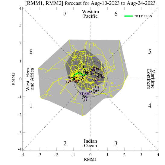
When it crashes to the center is the time we should expect to see a step-change to sustained warm up. I think the first week of May will be around normal, some days below, but by the time we get to the second week it should be noticeably warmer around here.
Expect cooler than normal conditions to persist another two weeks. We are seeing high latitude blocking (-NAO) across the Atlantic and a +PNA. The MJO is active in phases that favor cooler weather.

When it crashes to the center is the time we should expect to see a step-change to sustained warm up. I think the first week of May will be around normal, some days below, but by the time we get to the second week it should be noticeably warmer around here.
_________________
_______________________________________________________________________________________________________
CLICK HERE to view NJ Strong Snowstorm Classifications
Page 4 of 8 •  1, 2, 3, 4, 5, 6, 7, 8
Permissions in this forum:
You cannot reply to topics in this forum|
|
|

 Home
Home