
 Search
Long Range Discussion 20(20) (Ha!)
Page 3 of 30 •  1, 2, 3, 4 ... 16 ... 30
 ![]()
Re: Long Range Discussion 20(20) (Ha!)
![]() by algae888 Fri Nov 13, 2020 11:28 am
by algae888 Fri Nov 13, 2020 11:28 am
algae888- Advanced Forecaster

- Posts : 5311
Join date : 2013-02-05
Grselig likes this post
Re: Long Range Discussion 20(20) (Ha!)
![]() by Grselig Fri Nov 13, 2020 12:54 pm
by Grselig Fri Nov 13, 2020 12:54 pm
Grselig- Senior Enthusiast

- Posts : 1408
Join date : 2013-03-04
Re: Long Range Discussion 20(20) (Ha!)
![]() by Isotherm Sat Nov 14, 2020 11:49 am
by Isotherm Sat Nov 14, 2020 11:49 am
Isotherm- Advanced Forecaster
- Posts : 231
Reputation : 4
Join date : 2014-09-01
Age : 33
Location : Monmouth County, NJ -

Re: Long Range Discussion 20(20) (Ha!)
![]() by amugs Sat Nov 14, 2020 4:12 pm
by amugs Sat Nov 14, 2020 4:12 pm
Start from about the 20 minute mark to the 1 hour and 12 minute mark if you want to see from his research what he has to say. Very interesting. There are forces beyond our control that we need to recognize and accept. Enjoy and comment if you'd like.
_________________
Mugs
AKA:King: Snow Weenie
Self Proclaimed
WINTER 2014-15 : 55.12" +.02 for 6 coatings (avg. 35")
WINTER 2015-16 Total - 29.8" (Avg 35")
WINTER 2016-17 : 39.5" so far

amugs- Advanced Forecaster - Mod

- Posts : 15095
Reputation : 213
Join date : 2013-01-07
Age : 54
Location : Hillsdale,NJ
Re: Long Range Discussion 20(20) (Ha!)
![]() by amugs Sat Nov 14, 2020 4:26 pm
by amugs Sat Nov 14, 2020 4:26 pm
Isotherm wrote:Thanks all for the nice comments on the outlook. And I agree, Ray - hopefully the outcome is more favorable than expected.
Tom, I concur we will see what we have ben seeing which is the Meridional flow of the jet with warm and cold air intrusions throughout our winter and into our spring. There is a tremendous amount of cold air over head that will at time bleed into the conus and teh snow pack/glacier has been building for a good period of time now. Need that warm pocket of water to move about 200 miles more east and tuck it along the British Columbia/West Coast to get that High Pressure situation there. Time will tell but it looks to start off pretty good at the end of this month into early Dec. Question is can we get that MJO phase 2 to feed back off of itself??
_________________
Mugs
AKA:King: Snow Weenie
Self Proclaimed
WINTER 2014-15 : 55.12" +.02 for 6 coatings (avg. 35")
WINTER 2015-16 Total - 29.8" (Avg 35")
WINTER 2016-17 : 39.5" so far
amugs- Advanced Forecaster - Mod
- Posts : 15095
Reputation : 213
Join date : 2013-01-07
Age : 54
Location : Hillsdale,NJ
Re: Long Range Discussion 20(20) (Ha!)
![]() by amugs Tue Nov 17, 2020 8:17 pm
by amugs Tue Nov 17, 2020 8:17 pm
A positive over SE Canada = coastal storm for 2 nd week of Dec 15thish, rather it the 23rd but beggars can not be choosy
GEFS say this
EURO says this as well but a bit earlier
_________________
Mugs
AKA:King: Snow Weenie
Self Proclaimed
WINTER 2014-15 : 55.12" +.02 for 6 coatings (avg. 35")
WINTER 2015-16 Total - 29.8" (Avg 35")
WINTER 2016-17 : 39.5" so far
amugs- Advanced Forecaster - Mod
- Posts : 15095
Reputation : 213
Join date : 2013-01-07
Age : 54
Location : Hillsdale,NJ

dkodgis- Senior Enthusiast
- Posts : 2560
Reputation : 98
Join date : 2013-12-29
Re: Long Range Discussion 20(20) (Ha!)
![]() by frank 638 Tue Nov 17, 2020 8:28 pm
by frank 638 Tue Nov 17, 2020 8:28 pm
my fingers are crossedamugs wrote:We can only pray this comes to fruition for us snow weenies!!
A positive over SE Canada = coastal storm for 2 nd week of Dec 15thish, rather it the 23rd but beggars can not be choosy
GEFS say this
EURO says this as well but a bit earlier
frank 638- Senior Enthusiast
- Posts : 2843
Reputation : 37
Join date : 2016-01-01
Age : 40
Location : bronx ny
Re: Long Range Discussion 20(20) (Ha!)
![]() by mwilli Tue Nov 17, 2020 8:36 pm
by mwilli Tue Nov 17, 2020 8:36 pm
mwilli- Posts : 132
Reputation : 3
Join date : 2019-02-11
Re: Long Range Discussion 20(20) (Ha!)
![]() by rb924119 Wed Nov 18, 2020 8:51 am
by rb924119 Wed Nov 18, 2020 8:51 am
amugs wrote:We can only pray this comes to fruition for us snow weenies!!
A positive over SE Canada = coastal storm for 2 nd week of Dec 15thish, rather it the 23rd but beggars can not be choosy
GEFS say this
EURO says this as well but a bit earlier
Careful mugs, there’s A LOT of “warm” air in those maps, because you have no sourcing from truly cold domains - it would be Maritime Polar air which isn’t all that cold. Secondly, with the base state the way it is, that “blocking” you see is more likely than not to sync with eastern North American ridging, at least to some degree, as a direct consequence of a tightening Strstospheric PV and the Tropospheric PV continuing to reside over/near Alaska, thereby allowing much of North America to be flooded with Pacific (Maritime Polar) air, which does us no good.
rb924119- Meteorologist

- Posts : 6928
Reputation : 194
Join date : 2013-02-06
Age : 32
Location : Greentown, Pa
Re: Long Range Discussion 20(20) (Ha!)
![]() by amugs Wed Nov 18, 2020 5:37 pm
by amugs Wed Nov 18, 2020 5:37 pm
rb924119 wrote:amugs wrote:We can only pray this comes to fruition for us snow weenies!!
A positive over SE Canada = coastal storm for 2 nd week of Dec 15thish, rather it the 23rd but beggars can not be choosy
GEFS say this
EURO says this as well but a bit earlier
Careful mugs, there’s A LOT of “warm” air in those maps, because you have no sourcing from truly cold domains - it would be Maritime Polar air which isn’t all that cold. Secondly, with the base state the way it is, that “blocking” you see is more likely than not to sync with eastern North American ridging, at least to some degree, as a direct consequence of a tightening Strstospheric PV and the Tropospheric PV continuing to reside over/near Alaska, thereby allowing much of North America to be flooded with Pacific (Maritime Polar) air, which does us no good.
Rb, I take the stance that if you stick a positives over a cold and snowpack in SE Canada it going to bring in colder air - I am not saying frigid but colder air - BN. Wavelengths are shortening due to the seasonal changes and their are perturbations. The source is in the lower arctic region and I see the Positive EPO with that low but if you take that low and swing it more west (retrograde it) you get storms to undercut the HP. in an upside down parabola shape.
Time will tell but I am trying positive juju here my man
Pretty Cold Air with those positives at a different time frame yes but the idea of the surface cold air that is up in the region.

Time will tell.
_________________
Mugs
AKA:King: Snow Weenie
Self Proclaimed
WINTER 2014-15 : 55.12" +.02 for 6 coatings (avg. 35")
WINTER 2015-16 Total - 29.8" (Avg 35")
WINTER 2016-17 : 39.5" so far
amugs- Advanced Forecaster - Mod
- Posts : 15095
Reputation : 213
Join date : 2013-01-07
Age : 54
Location : Hillsdale,NJ
Re: Long Range Discussion 20(20) (Ha!)
![]() by amugs Fri Nov 20, 2020 12:47 pm
by amugs Fri Nov 20, 2020 12:47 pm
A trough over the east coast at the endish of the run this is very similar to what we have seen this summer at various times and aided in teh tropical cyclone development as per JB - High Pressure over SE Canada and a trough builds or retrogrades east. Gives us chances for white or mixed storms - hey its a start in Dec.
From another board member on another site (33&rain)made this GIF
Build those heights over SE Canada and we should be in a slightly to moderate below normal weather pattern for temps at times from my studying this type of pattern. Could it be wrong this far out? Of course but it has been trending this way for the past few days now. Need it to keep doing so.
.gif.2e8969e560be5420a46ba11b2439cf05.gif)
I think we see about a 20 period of this and just after xmass we hate to say go mild and then we come back about 20-25 days later and run through Early Mid March with the same type of pattern as I am seeing the cycles from this summer and fall have gone. Lets see if that works this winter. Early Spring could be eeh once this PV breaks down again if it gets as strong as it did last year.
Time will tell.
_________________
Mugs
AKA:King: Snow Weenie
Self Proclaimed
WINTER 2014-15 : 55.12" +.02 for 6 coatings (avg. 35")
WINTER 2015-16 Total - 29.8" (Avg 35")
WINTER 2016-17 : 39.5" so far
amugs- Advanced Forecaster - Mod
- Posts : 15095
Reputation : 213
Join date : 2013-01-07
Age : 54
Location : Hillsdale,NJ
Re: Long Range Discussion 20(20) (Ha!)
![]() by rb924119 Fri Nov 20, 2020 4:37 pm
by rb924119 Fri Nov 20, 2020 4:37 pm
amugs wrote:rb924119 wrote:amugs wrote:We can only pray this comes to fruition for us snow weenies!!
A positive over SE Canada = coastal storm for 2 nd week of Dec 15thish, rather it the 23rd but beggars can not be choosy
GEFS say this
EURO says this as well but a bit earlier
Careful mugs, there’s A LOT of “warm” air in those maps, because you have no sourcing from truly cold domains - it would be Maritime Polar air which isn’t all that cold. Secondly, with the base state the way it is, that “blocking” you see is more likely than not to sync with eastern North American ridging, at least to some degree, as a direct consequence of a tightening Strstospheric PV and the Tropospheric PV continuing to reside over/near Alaska, thereby allowing much of North America to be flooded with Pacific (Maritime Polar) air, which does us no good.
Rb, I take the stance that if you stick a positives over a cold and snowpack in SE Canada it going to bring in colder air - I am not saying frigid but colder air - BN. Wavelengths are shortening due to the seasonal changes and their are perturbations. The source is in the lower arctic region and I see the Positive EPO with that low but if you take that low and swing it more west (retrograde it) you get storms to undercut the HP. in an upside down parabola shape.
Time will tell but I am trying positive juju here my man
Pretty Cold Air with those positives at a different time frame yes but the idea of the surface cold air that is up in the region.
Time will tell.
Oh, I completely understand your reasoning here, mugs, and it’s logical. But in my opinion there’s just too much maritime air flooding the CONUS. Here’s my post from “elsewhere”, but if I have time at some point during the next few days, I’ll try to elaborate and make my worries/expectations of the forthcoming pattern more clear:
“ I wish I could add more, but I will say the following: I am still hesitant to get excited about any prolonged BN regime, and even significant snow prospects, in our area, and agree with @Analog96 in that I can see us averaging out near, maybe a little bit above average (i.e. something like 0-2° above average) during the next two weeks (or so). Even though I like seeing a 70/70 ridge trying to pop and the trough axis does seem to be backing off a bit, I fear that the modeled Aleutian trough will end up fracturing as we get closer in time and end up as a parade of troughs, with any amplitude that we do manage to see out west stunted by anti-cyclonic wave breaks over western North America and ridging then blasting along/near the U.S.-Canadian border as the energy trapped beneath is forced to ball up. Then, as one remnant ridge top evacuates to our northeast, the system will begin gaining latitude to our west. There’s just so much zonal momentum in the mid- and high-lat belts right now, coupled with generally unfavorable tropical forcing, I can’t see a prolonged and favorably amplified pattern taking hold.
Hopefully that makes sense, but I can’t elaborate further because I’m at work lol”
rb924119- Meteorologist
- Posts : 6928
Reputation : 194
Join date : 2013-02-06
Age : 32
Location : Greentown, Pa
Re: Long Range Discussion 20(20) (Ha!)
![]() by amugs Fri Nov 20, 2020 6:23 pm
by amugs Fri Nov 20, 2020 6:23 pm
Thank you for the respectfully and informational post. I hear you and the momentum at the mid and higher latitudes. The NJO is non existence right now and forecasted to be so, that remains to be seen of course.
The almighty EURO is coming around to tnis idea as well.Now for absolutely drooling troughs by the GFS in the LR would have weenies in delight, take with a grain of salt.


_________________
Mugs
AKA:King: Snow Weenie
Self Proclaimed
WINTER 2014-15 : 55.12" +.02 for 6 coatings (avg. 35")
WINTER 2015-16 Total - 29.8" (Avg 35")
WINTER 2016-17 : 39.5" so far
amugs- Advanced Forecaster - Mod
- Posts : 15095
Reputation : 213
Join date : 2013-01-07
Age : 54
Location : Hillsdale,NJ
rb924119 likes this post
Re: Long Range Discussion 20(20) (Ha!)
![]() by rb924119 Sat Nov 21, 2020 12:58 am
by rb924119 Sat Nov 21, 2020 12:58 am
amugs wrote:Rb,
Thank you for the respectfully and informational post. I hear you and the momentum at the mid and higher latitudes. The NJO is non existence right now and forecasted to be so, that remains to be seen of course.
The almighty EURO is coming around to tnis idea as well.Now for absolutely drooling troughs by the GFS in the LR would have weenies in delight, take with a grain of salt.
I guess you saw my explosion on Eric, eh? Lol you’re fine mugsy. I honestly don’t think that anybody on this forum could be as blatantly disrespectful and dismissive as he is/was if they tried. I don’t take any issue at all with people who disagree with me, so long as it’s done respectfully (which again, has never not been the case here, and quite frankly, is the most fun for me because it tests me), but he crossed the line, no matter how much I still respect his work.
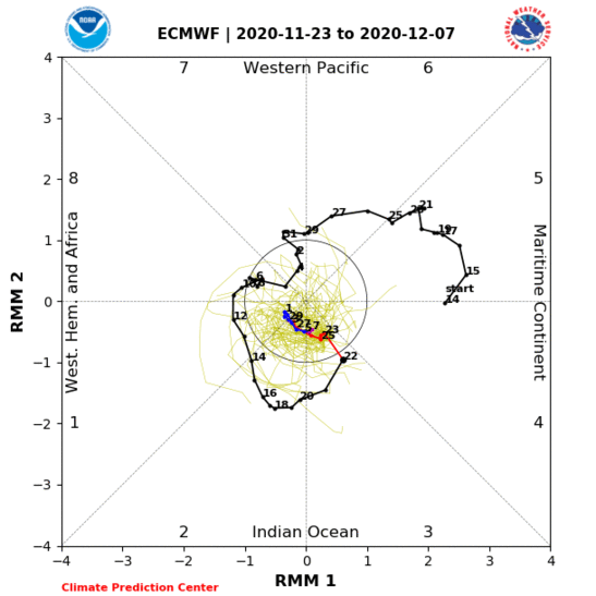
Anyway, regarding the MJO, the phase space plots you see with ensembles are WAY off in my opinion, as they continue to show the MJO crashing rapidly into the Null Phase (as you stated) while progressing from Phase 2 to Phase 3. If you were to assume this evolution is correct, then actually what we are seeing right now in the ensemble mean height fields for the Northern Hemisphere in the extended range would make physical sense, and broadly support a pattern reversal, with ridging in western North America and troughing in eastern North America in the time-mean, albeit relatively briefly before the MJO’s likely emergence back into Phase 5 or 6, which would bring the pattern back to where it has been about a week or two later.
HOWEVER, and I brought this up “elsewhere”, I do not think the MJO forecasts are correct, AT ALL, and that instead of the above evolution, fully believe that the pulse will steadily gain amplitude as it works into Phase 3 and closer toward the Maritime Continent. My reason for this is the well-established standing wave that has been present since the latter portions of Summer which is favoring large-scale ascent in and around the Maritime Continent. Conceptually, this would mean that we should see the MJO propagate with enhanced amplitudes through phases 4-7 (Maritime Continent), decrease through 8 (Central Pacific), remain at relatively muted amplitude in phases 1 and 2 (Eastern Pacific-Central Indian Ocean), and then begin gaining amplitude as it works into Phase 3 (Eastern Indian Ocean).
This would be further bolstered by the current equatorial SST anomaly configuration, wherein you have cooler anomalies colocated with the generally subsident regions of the standing wave (relatively higher pressure at the surface, thereby further working to inhibit convective initiation and thermodynamic input) and warmer anomalies where you have generally ascending regions of the standing (relatively lower pressure at the surface, thereby further working to enhance convective initiation and thermodynamic input).
When you look at the observed MJO plot for the last few months, you see this is exactly what you have had, which helps to explain the general tendency for a ridge in eastern North America and a trough out west. Until there are physical signs of this standing wave beginning to break down, OR happenings with the Stratospheric Vortex (which I admittedly also do not foresee happening anytime soon, unfortunately) the same general pattern that we have had is likely to persist, again, in my opinion, and we should see the MJO plots eventually catch on with increased amplitude. I’m not sure why they keep trying to kill off the convection, but based on my hypothesis, the maps we are currently seeing at H5 for the Northern Hemisphere are unlikely to still look that way once inside of Day 8-10 as the modeling continues to correct, and I think they will end up looking like what I described earlier.
rb924119- Meteorologist
- Posts : 6928
Reputation : 194
Join date : 2013-02-06
Age : 32
Location : Greentown, Pa
sroc4 and Wheezer like this post
Re: Long Range Discussion 20(20) (Ha!)
![]() by Frank_Wx Mon Nov 23, 2020 9:31 am
by Frank_Wx Mon Nov 23, 2020 9:31 am
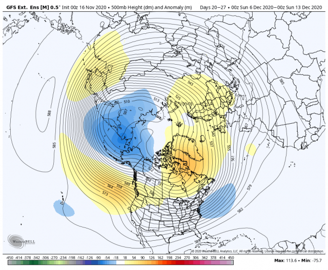
You know what would turn 2020 around? A Godzilla in December. A December to remember. Let’s take a look at what’s going on in the atmosphere.
First, we are in the middle of an active MJO cycle that has seen convection develop and propagate eastward across regions 1, 2, and 3 of the Pacific.
Activity in these regions of the MJO normally translates to an upper level pattern that promotes cooler and wetter than normal weather conditions in the eastern US. Important to remember it is best to use the Ensembles to draw analysis and insights of the long range weather pattern, and not so much the individual OP models. Last nights EURO Ensemble shows an intense pattern forming after Thanksgiving.
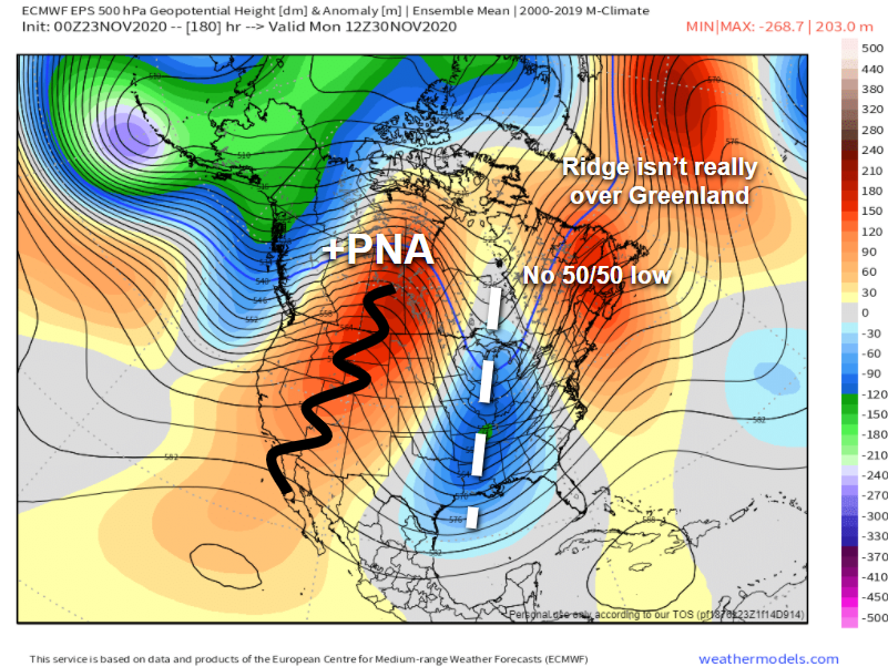
As shown, this is a textbook +PNA/+EPO pattern that would bring colder than normal temps to our area in early December. The STJ, or sub tropical jet stream, would force low pressure systems to develop in the SE part of the country and potentially move up the coast. As we all know by this point, slight interaction with the northern jet stream would mean the formation of a powerful coastal storm.
The +PNA is modeled to be very anomalous. If it’s too strong, the STJ would be most active near the Gulf and risk storm systems being too far south for them to have an impact in the north. Another thing to think about is the AO/NAO are not forecasted to be negative at that time. The NAO tries really hard, and maybe timing with a more neutral phase works in our favor, but the Stratospheric conditions promote +AO/+NAO conditions for the foreseeable future.
In fact, I was going to show some data around this. See below...
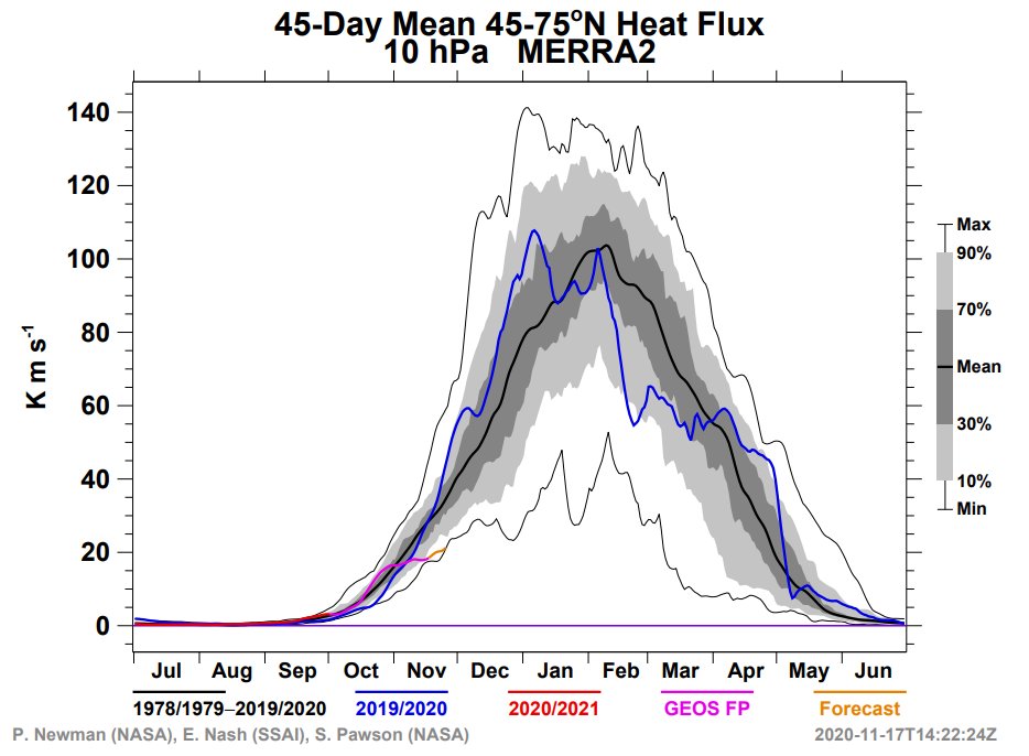
The first image is 10mb temps in the Stratosphere. The purple line is the current forecast while the blue line shows last years actuals. Notice how much cooler the strat is this year, and that’s because there hasn’t been strong enough storms in the Troposphere that would send warmth north into the Stratosphere. A developing strong La Niña and poor QBO likely has something to do with that. But I’m no expert! Main takeaway from this image is that the Strat PV (Polar Vortex) is going to be stronger than normal. This equates to colder than normal conditions for the Polar regions (+AO/+NAO). Unfortunately, that does not bold well for us. That said, a large scale warming event (SSWE) would BREAK that pattern quickly and give our area an opportunity to capitalize on possible -AO/-NAO conditions. We’ll have to see if the pattern will allow any SSWE to occur in areas where it matters most for us.
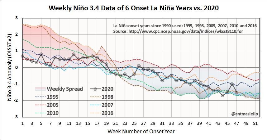
The second image is a look at the current progression of La Niña. It is ALREADY approaching “strong” status as SSTAs in the 3.4 region of the equatorial Pacific fall below -1 C. But, I just finished saying how the pattern is looking more El Niño-esque to start out December? That’s because of the MJO, but you can bet by the time we are in middle to late December you’ll see a pattern dominated by La Niña. This normally means average or slightly above average temps for our area. It depends how far north the SE ridge tries to get. La Niña normally means active weather in terms of precipitation. Could be looking at a lot of rain/mixed weather type of events.
Hopefully we take advantage of early December before the pattern flips unfavorably. Then we need to hope for a strong SSWE to break the anomalously strong Strat PV that is forming as we speak.
_________________
_______________________________________________________________________________________________________
CLICK HERE to view NJ Strong Snowstorm Classifications

Frank_Wx- Godzilla Seeker

- Posts : 21305
Reputation : 328
Join date : 2013-01-05
Age : 32
Location : Jersey City, NJ -
Re: Long Range Discussion 20(20) (Ha!)
![]() by Frank_Wx Mon Nov 23, 2020 12:27 pm
by Frank_Wx Mon Nov 23, 2020 12:27 pm
https://www.lightinthestorm.com/
His outlook touches on some of the things from my last post. The cold is going to stay bottled up in the Arctic. Wildcard being a SSWE, but likelihood appears very low.
_________________
_______________________________________________________________________________________________________
CLICK HERE to view NJ Strong Snowstorm Classifications
Frank_Wx- Godzilla Seeker
- Posts : 21305
Reputation : 328
Join date : 2013-01-05
Age : 32
Location : Jersey City, NJ -
Re: Long Range Discussion 20(20) (Ha!)
![]() by amugs Mon Nov 23, 2020 2:40 pm
by amugs Mon Nov 23, 2020 2:40 pm
Frank_Wx wrote:Everyone is familiar with Isotherm. Here is his winter outlook. Probably one of the only forecasters I pay most attention to.
https://www.lightinthestorm.com/
His outlook touches on some of the things from my last post. The cold is going to stay bottled up in the Arctic. Wildcard being a SSWE, but likelihood appears very low.
Frank - Tom (IsoTherm) posted here as did Sroc and some one else last week this and we discussed this with Tom. Good to re-iterate this.
We shall see what also happens in the Trop Pac and what that blob off the West Coast does to the jet structure but I do not see long lasting cold, but rather what we are seeing in ebb and flow of a Meridional Jet Stream as we have seen. This is mainly due to the Solar Minimum as has been witnessed many times before.
With that first 2-3 weeks of December looks like it could be cold and stormy before the NINA takes over along with the PV.
Euro Ensembles 1st one cuts west but interior can see some white gold
this one IF this holds true has the potential for snow to the coastal plain and become a Nor/Coastal Low

_________________
Mugs
AKA:King: Snow Weenie
Self Proclaimed
WINTER 2014-15 : 55.12" +.02 for 6 coatings (avg. 35")
WINTER 2015-16 Total - 29.8" (Avg 35")
WINTER 2016-17 : 39.5" so far
amugs- Advanced Forecaster - Mod
- Posts : 15095
Reputation : 213
Join date : 2013-01-07
Age : 54
Location : Hillsdale,NJ
Re: Long Range Discussion 20(20) (Ha!)
![]() by rb924119 Mon Nov 23, 2020 8:30 pm
by rb924119 Mon Nov 23, 2020 8:30 pm
rb924119- Meteorologist
- Posts : 6928
Reputation : 194
Join date : 2013-02-06
Age : 32
Location : Greentown, Pa
Re: Long Range Discussion 20(20) (Ha!)
![]() by amugs Mon Nov 23, 2020 8:32 pm
by amugs Mon Nov 23, 2020 8:32 pm
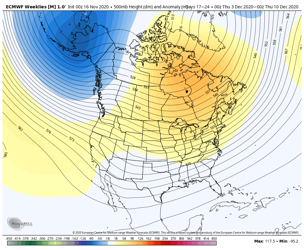
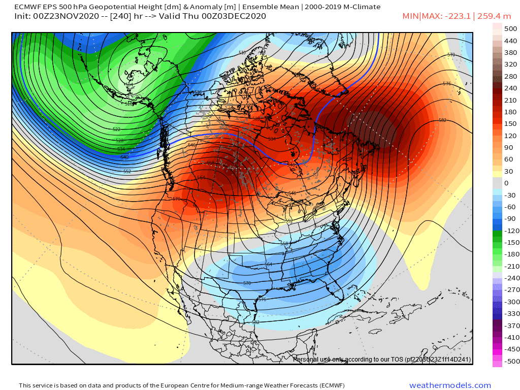
Moving forward, as I mentioned in my "outlook" write-up over the weekend, a signal continues to show up on most extended guidance for a pattern featuring an Aleutian low and Scandinavian-Ural high late November into a good portion of December. This is a pattern that is a pretty good match to what has been observed prior to stratospheric warming events, and the newest run of the ECMWF weeklies show a noticeable signal to weaken the PV mid-December into early January (though, not every member does so):
December will likely be mild as a whole across the CONUS...though, most of that warmth is focused well west of where most of this forum lives, and there probably will be some snow in the eastern U.S. While the early December +PNA pattern is interesting, I'm more intrigued for the second or third week of the month when the EPO may drop, especially if the sub-tropical jet remains reasonably active. The signs of a weakening polar vortex later in December into January may well deliver a much colder month of January overall across the CONUS than December if it comes to fruition...though, where exactly that cold dumps in would need be worked out as we get closer.
ZONAL WINDS CHART INTERESTING YREND IF TRUE AND IT CONTINUES.
Watch the trend on the zonal mean. Last 3 updates: 16, 19, 23


Let's see what happens in a couple weeks time if this is true trend or a false event
_________________
Mugs
AKA:King: Snow Weenie
Self Proclaimed
WINTER 2014-15 : 55.12" +.02 for 6 coatings (avg. 35")
WINTER 2015-16 Total - 29.8" (Avg 35")
WINTER 2016-17 : 39.5" so far
amugs- Advanced Forecaster - Mod
- Posts : 15095
Reputation : 213
Join date : 2013-01-07
Age : 54
Location : Hillsdale,NJ
Re: Long Range Discussion 20(20) (Ha!)
![]() by Frank_Wx Mon Nov 23, 2020 9:13 pm
by Frank_Wx Mon Nov 23, 2020 9:13 pm
rb924119 wrote:Frank, always good to see you back at your rightful helm!! However, I am going to continue to respectfully disagree, though I will not be able to go into detail until probably Thanksgiving. That said, I’ve made some of my basic points already, but fully intend to tie them together with respect to the maps.
Hi rb! Hope you are well.
Curious, which part of my post are you disagreeing with? The short-term pattern evolution into early December or the long range overall winter prospects? Or both!
_________________
_______________________________________________________________________________________________________
CLICK HERE to view NJ Strong Snowstorm Classifications
Frank_Wx- Godzilla Seeker
- Posts : 21305
Reputation : 328
Join date : 2013-01-05
Age : 32
Location : Jersey City, NJ -
rb924119 likes this post
Re: Long Range Discussion 20(20) (Ha!)
![]() by Frank_Wx Mon Nov 23, 2020 9:17 pm
by Frank_Wx Mon Nov 23, 2020 9:17 pm
amugs wrote:Very interesting from a pro Mets on another board
Moving forward, as I mentioned in my "outlook" write-up over the weekend, a signal continues to show up on most extended guidance for a pattern featuring an Aleutian low and Scandinavian-Ural high late November into a good portion of December. This is a pattern that is a pretty good match to what has been observed prior to stratospheric warming events, and the newest run of the ECMWF weeklies show a noticeable signal to weaken the PV mid-December into early January (though, not every member does so):
December will likely be mild as a whole across the CONUS...though, most of that warmth is focused well west of where most of this forum lives, and there probably will be some snow in the eastern U.S. While the early December +PNA pattern is interesting, I'm more intrigued for the second or third week of the month when the EPO may drop, especially if the sub-tropical jet remains reasonably active. The signs of a weakening polar vortex later in December into January may well deliver a much colder month of January overall across the CONUS than December if it comes to fruition...though, where exactly that cold dumps in would need be worked out as we get closer.
ZONAL WINDS CHART INTERESTING YREND IF TRUE AND IT CONTINUES.
Watch the trend on the zonal mean. Last 3 updates: 16, 19, 23
Let's see what happens in a couple weeks time if this is true trend or a false event
Hmmm, unless I'm missing something, these forecasts only show one member out of hundreds with zonal winds becoming neutral to negative. There is no true reversal (as shown).
We're not even in December yet. I am curious to see these same graphs in December Week 03.
_________________
_______________________________________________________________________________________________________
CLICK HERE to view NJ Strong Snowstorm Classifications
Frank_Wx- Godzilla Seeker
- Posts : 21305
Reputation : 328
Join date : 2013-01-05
Age : 32
Location : Jersey City, NJ -
Re: Long Range Discussion 20(20) (Ha!)
![]() by Frank_Wx Mon Nov 23, 2020 9:27 pm
by Frank_Wx Mon Nov 23, 2020 9:27 pm
sroc4 wrote:Here is earthlight’s (John Homenuk) forecast. Don’t shoot the messenger. Still waiting for Isotherm
https://www.nymetroweather.com/2020/11/09/nyc-winter-forecast-2020-2021-warmer-less-snowy-than-normal/
Good read, thanks for sharing Scott. I remember last season John had a fairly bullish call for colder/snowier than normal conditions, but quickly realized halfway through that was not going to happen. This time, he seems to be part of the general consensus (unfortunately).
Dunnzoo wrote:Here is Larry's thoughts, sorry it's a little hard to read:

He kinda seems all over the map, but his last bullet point makes the most sense to me
Isotherm wrote:sroc4 wrote:Dunnzoo wrote:Funny how these 2 are so different! Hopefully Isotherm's helps shed some more light.
Totally Janet. I’ve been following Larry for a long time. He is great but he leans heavily on the analogs. Problem is this year is that any mod or strong La Niña years don’t have a ton in in common with the current SST configurations anywhere else in the world, the mean pattern leading into the current time frame is very different from La Niña years past, and the timing of sunspot cycle is vastly diff to prev analogue years. So LR forecasters are needing to add a bit of intuition into the forecast this year. We shall see. I know earthlight and Isotherm corroborate when formulating their conclusions but they have differed in years past. Isotherm has been the most consistently accurate LR forecaster I’ve seen over the past 3-5 yrs. so while of course he isn’t perfect his thoughts weigh the most in my kind until proven otherwise.
Thanks for the kind words, Scott. Was going to post my outlook here today (I see someone posted it above). Can be read on my website:
https://www.lightinthestorm.com/
Also, note: earthlight/John and I don't collaborate on the winter outlooks (my outlooks are entirely my own viewpoints). Only one winter (2013-14) we collaborated.
Unfortunately, wish I could deliver better news, but this is where the data led me. My most significant disagreement with many of the forecasts out there involves the placement of the warm/cooler anomalies in the CONUS, and the timing of the colder/warmer periods. I target January for the best opportunity for cold/snow, rather than the consensus which seems to be December.
Funny how I re-posted your outlook without realizing it was already posted by other members on here who greatly value your work.
As always, nice job. Hope all is well.
_________________
_______________________________________________________________________________________________________
CLICK HERE to view NJ Strong Snowstorm Classifications
Frank_Wx- Godzilla Seeker
- Posts : 21305
Reputation : 328
Join date : 2013-01-05
Age : 32
Location : Jersey City, NJ -
Re: Long Range Discussion 20(20) (Ha!)
![]() by Frank_Wx Tue Nov 24, 2020 10:51 am
by Frank_Wx Tue Nov 24, 2020 10:51 am

I’m not particularly excited for snow prospects just yet, but at least it’s looking cold to start December
_________________
_______________________________________________________________________________________________________
CLICK HERE to view NJ Strong Snowstorm Classifications
Frank_Wx- Godzilla Seeker
- Posts : 21305
Reputation : 328
Join date : 2013-01-05
Age : 32
Location : Jersey City, NJ -
Re: Long Range Discussion 20(20) (Ha!)
![]() by Frank_Wx Tue Nov 24, 2020 10:53 am
by Frank_Wx Tue Nov 24, 2020 10:53 am
https://twitter.com/met_khinz/status/1331263865280147459?s=21
_________________
_______________________________________________________________________________________________________
CLICK HERE to view NJ Strong Snowstorm Classifications
Frank_Wx- Godzilla Seeker
- Posts : 21305
Reputation : 328
Join date : 2013-01-05
Age : 32
Location : Jersey City, NJ -
Re: Long Range Discussion 20(20) (Ha!)
![]() by Irish Tue Nov 24, 2020 12:07 pm
by Irish Tue Nov 24, 2020 12:07 pm
https://twitter.com/jhomenuk/status/1331260807599050754?s=20

Irish- Pro Enthusiast

- Posts : 788
Reputation : 19
Join date : 2019-01-16
Age : 45
Location : Old Bridge, NJ
Re: Long Range Discussion 20(20) (Ha!)
![]() by amugs Tue Nov 24, 2020 1:01 pm
by amugs Tue Nov 24, 2020 1:01 pm

_________________
Mugs
AKA:King: Snow Weenie
Self Proclaimed
WINTER 2014-15 : 55.12" +.02 for 6 coatings (avg. 35")
WINTER 2015-16 Total - 29.8" (Avg 35")
WINTER 2016-17 : 39.5" so far
amugs- Advanced Forecaster - Mod
- Posts : 15095
Reputation : 213
Join date : 2013-01-07
Age : 54
Location : Hillsdale,NJ
Page 3 of 30 • 1, 2, 3, 4 ... 16 ... 30 ![]()
|
|
|