Long Range Discussion 20(20) (Ha!)
+43
toople
TheAresian
Koroptim
Bkdude
essexcountypete
chief7
GreyBeard
crippo84
hyde345
lglickman1
Zhukov1945
bloc1357
SENJsnowman
Snow88
CPcantmeasuresnow
bobjohnsonforthehall
weatherwatchermom
skinsfan1177
billg315
SoulSingMG
phil155
aiannone
nutleyblizzard
Math23x7
Wheezer
Irish
Frank_Wx
mwilli
Grselig
Isotherm
heehaw453
jimv45
frank 638
docstox12
rb924119
sroc4
HectorO
algae888
dkodgis
Radz
jmanley32
amugs
Dunnzoo
47 posters
Page 4 of 30
Page 4 of 30 •  1, 2, 3, 4, 5 ... 17 ... 30
 Re: Long Range Discussion 20(20) (Ha!)
So what does this all mean?
https://twitter.com/jhomenuk/status/1331260807599050754?s=20
https://twitter.com/jhomenuk/status/1331260807599050754?s=20
Irish- Pro Enthusiast

- Posts : 788
Join date : 2019-01-16
 Re: Long Range Discussion 20(20) (Ha!)
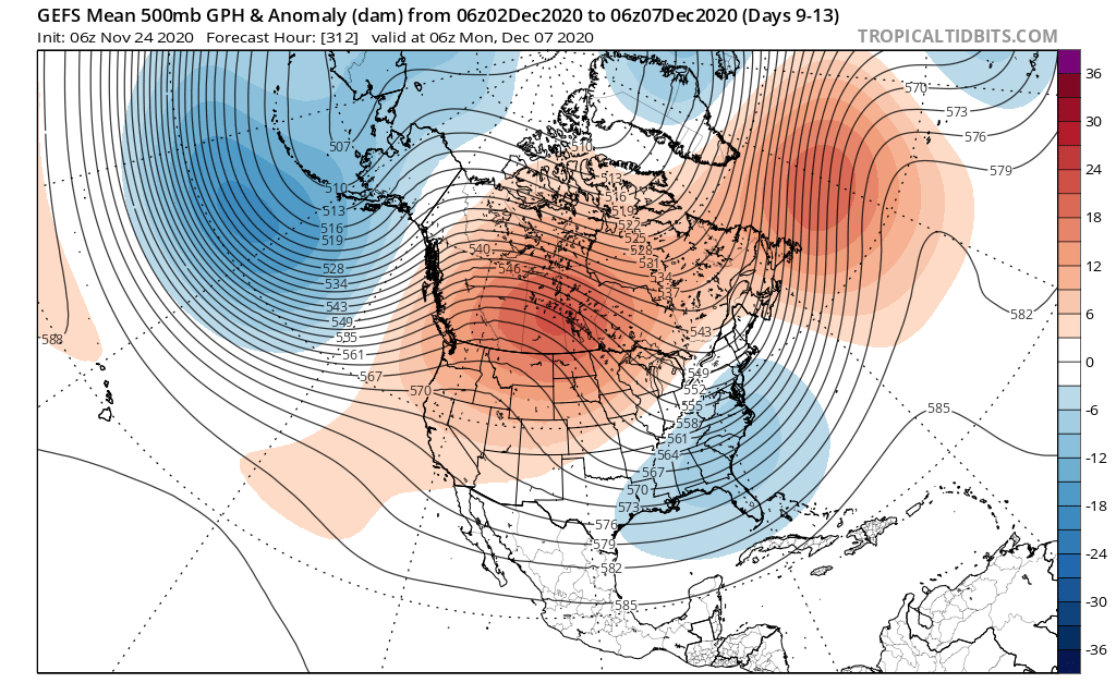
Okay, IF we can get the Ural Block to stay put for a bit it MAY help with a warming of teh Stratosphere and knock around the Polar Vortex - Just a hunch and idea I have read before and elsewhere. Look at the PNA ridge POP and the Trough swing under the CANADIAN Block that forms.


amugs- Advanced Forecaster - Mod

- Posts : 15130
Join date : 2013-01-07
 Re: Long Range Discussion 20(20) (Ha!)
Yes it's finally looking like we have an interesting December coming up after many many years of warm and snowless December. We'll probably have to wait till the second week of December for any snow chances as Canada will be very warm as well much of the u.s. the Alaskan low / Vortex looks to retrograde West and the EPO looks to go at least neutral which should start to deliver some cold into the east and with a more Nino like pattern the subtropical jet will be active so we just have to time one of these short waves. Also of interest is the mjo which for the next month looks to stay in 1 and 2 and I'm hearing from many Mets and other weather enthusiasts that it will stay in the Indian Ocean this winter and not the maritime continent which is phases. 4 5 and 6 we shall see but much different setup than last year

algae888- Advanced Forecaster

- Posts : 5311
Reputation : 46
Join date : 2013-02-05
Age : 62
Location : mt. vernon, new york
 Re: Long Range Discussion 20(20) (Ha!)
Irish wrote:So what does this all mean?
https://twitter.com/jhomenuk/status/1331260807599050754?s=20
It echoes what I said yesterday. Pattern will behave more like El Niño than La Niña to start December. Don’t bank on that lasting very long.
amugs wrote:Okay, IF we can get the Ural Block to stay put for a bit it MAY help with a warming of teh Stratosphere and knock around the Polar Vortex - Just a hunch and idea I have read before and elsewhere. Look at the PNA ridge POP and the Trough swing under the CANADIAN Block that forms.
There will be some disruption, but the SPV will re-emerge even stronger
_________________
_______________________________________________________________________________________________________
CLICK HERE to view NJ Strong Snowstorm Classifications
Irish likes this post
 Re: Long Range Discussion 20(20) (Ha!)
algae888 wrote:Yes it's finally looking like we have an interesting December coming up after many many years of warm and snowless December. We'll probably have to wait till the second week of December for any snow chances as Canada will be very warm as well much of the u.s. the Alaskan low / Vortex looks to retrograde West and the EPO looks to go at least neutral which should start to deliver some cold into the east and with a more Nino like pattern the subtropical jet will be active so we just have to time one of these short waves. Also of interest is the mjo which for the next month looks to stay in 1 and 2 and I'm hearing from many Mets and other weather enthusiasts that it will stay in the Indian Ocean this winter and not the maritime continent which is phases. 4 5 and 6 we shall see but much different setup than last year
MJO will be a wild card for sure.
I’m not sure what to make of it. Central/eastern La Niña forcing or MJO activity? Who will win out?
_________________
_______________________________________________________________________________________________________
CLICK HERE to view NJ Strong Snowstorm Classifications
 Re: Long Range Discussion 20(20) (Ha!)
Frank_Wx wrote:Irish wrote:So what does this all mean?
https://twitter.com/jhomenuk/status/1331260807599050754?s=20
It echoes what I said yesterday. Pattern will behave more like El Niño than La Niña to start December. Don’t bank on that lasting very long.amugs wrote:Okay, IF we can get the Ural Block to stay put for a bit it MAY help with a warming of teh Stratosphere and knock around the Polar Vortex - Just a hunch and idea I have read before and elsewhere. Look at the PNA ridge POP and the Trough swing under the CANADIAN Block that forms.
There will be some disruption, but the SPV will re-emerge even stronger
Frank it will be seen what happens with the SPV, if we can get the warming with the heights over the top it may hold it off for a bit longer.
I said this to a friend if we notice the pattern observations since Julyish and as of late it is 20-25 days pattern then a flip for a about teh same time then a revert back. Fun times ahead figuring our what the models and what is happening .
From Ventrice to my point above
https://twitter.com/MJVentrice/status/1331263867259850757?s=20
So what does this chart mean?? With Solar affects on our planet talk about LR and SLR !!

It means the influx of solar irradiance and cosmic rays on our planet are increasing by a good amount which means that we will have and see more cloudy days overall on the planet and more precipitable days in certain regions. This also increases the likelihood of hail storms and increasing their severity. It also and lastly (not really) affects the jet structure to make it more wavy not zonal. It does have affects on physiological and psychological aspects of us humans.
Massive Sunspot and its flaring coming to face earth in the next 2 -3 days - watch for an uptick in Puffers (volcanoes) and Rockers (earthquakes). Could also have communication disruptions depending of its level.

_________________
Mugs
AKA:King: Snow Weenie
Self Proclaimed
WINTER 2014-15 : 55.12" +.02 for 6 coatings (avg. 35")
WINTER 2015-16 Total - 29.8" (Avg 35")
WINTER 2016-17 : 39.5" so far

amugs- Advanced Forecaster - Mod

- Posts : 15130
Reputation : 213
Join date : 2013-01-07
Age : 54
Location : Hillsdale,NJ
 Re: Long Range Discussion 20(20) (Ha!)
Hey all I hope everyone is doing good tonight on channel 4 Janice and her weather team is having their winter outlook starting at 6 and 11 hopefully it’s a good one
frank 638- Senior Enthusiast

- Posts : 2862
Reputation : 37
Join date : 2016-01-01
Age : 41
Location : bronx ny
 Re: Long Range Discussion 20(20) (Ha!)
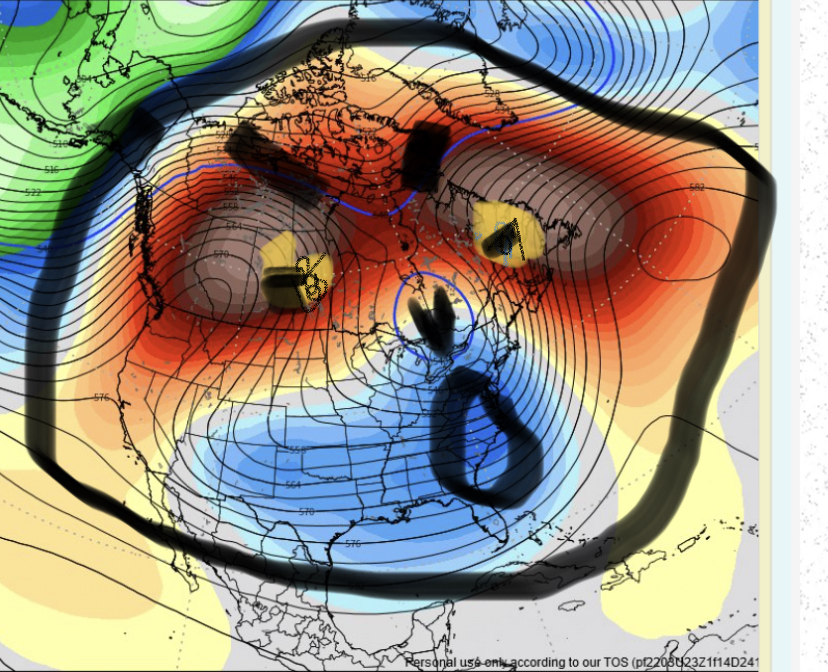
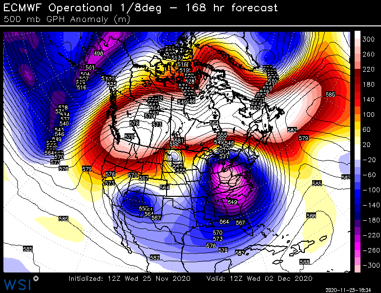
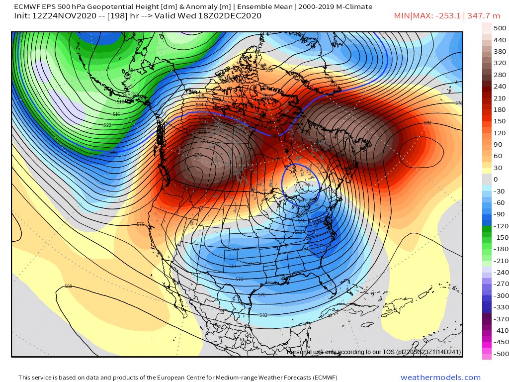
Wow- omega block

_________________
Mugs
AKA:King: Snow Weenie
Self Proclaimed
WINTER 2014-15 : 55.12" +.02 for 6 coatings (avg. 35")
WINTER 2015-16 Total - 29.8" (Avg 35")
WINTER 2016-17 : 39.5" so far

amugs- Advanced Forecaster - Mod

- Posts : 15130
Reputation : 213
Join date : 2013-01-07
Age : 54
Location : Hillsdale,NJ
 Re: Long Range Discussion 20(20) (Ha!)
amugs wrote:Wow- omega block
If that were to happen, would that be a Nor'easter?

Irish- Pro Enthusiast

- Posts : 788
Reputation : 19
Join date : 2019-01-16
Age : 46
Location : Old Bridge, NJ
 Re: Long Range Discussion 20(20) (Ha!)
frank 638 wrote:Hey all I hope everyone is doing good tonight on channel 4 Janice and her weather team is having their winter outlook starting at 6 and 11 hopefully it’s a good one
Let us know what she says
Irish wrote:amugs wrote:Wow- omega block
If that were to happen, would that be a Nor'easter?
Maybe for North Carolina...
_________________
_______________________________________________________________________________________________________
CLICK HERE to view NJ Strong Snowstorm Classifications
 Re: Long Range Discussion 20(20) (Ha!)
_________________
"In weather and in life, there's no winning and losing; there's only winning and learning."
WINTER 2012/2013 TOTALS 43.65"WINTER 2017/2018 TOTALS 62.85" WINTER 2022/2023 TOTALS 4.9"
WINTER 2013/2014 TOTALS 64.85"WINTER 2018/2019 TOTALS 14.25" WINTER 2023/2024 TOTALS 13.1"
WINTER 2014/2015 TOTALS 71.20"WINTER 2019/2020 TOTALS 6.35"
WINTER 2015/2016 TOTALS 35.00"WINTER 2020/2021 TOTALS 37.75"
WINTER 2016/2017 TOTALS 42.25"WINTER 2021/2022 TOTALS 31.65"

sroc4- Admin

- Posts : 8441
Reputation : 302
Join date : 2013-01-07
Location : Wading River, LI
rb924119 likes this post
 Re: Long Range Discussion 20(20) (Ha!)
Scott: good man!

dkodgis- Senior Enthusiast

- Posts : 2663
Reputation : 98
Join date : 2013-12-29
 Re: Long Range Discussion 20(20) (Ha!)
Janice Huff's take:
https://www.nbcnewyork.com/weather/less-snow-not-as-cold-storm-team-4s-2020-2021-winter-outlook/2743751/
https://www.nbcnewyork.com/weather/less-snow-not-as-cold-storm-team-4s-2020-2021-winter-outlook/2743751/
_________________
Janet
Snowfall winter of 2023-2024 17.5"
Snowfall winter of 2022-2023 6.0"
Snowfall winter of 2021-2022 17.6" 1" sleet 2/25/22
Snowfall winter of 2020-2021 51.1"
Snowfall winter of 2019-2020 8.5"
Snowfall winter of 2018-2019 25.1"
Snowfall winter of 2017-2018 51.9"
Snowfall winter of 2016-2017 45.6"
Snowfall winter of 2015-2016 29.5"
Snowfall winter of 2014-2015 50.55"
Snowfall winter of 2013-2014 66.5"
Dunnzoo- Senior Enthusiast - Mod

- Posts : 4920
Reputation : 68
Join date : 2013-01-11
Age : 62
Location : Westwood, NJ
 Re: Long Range Discussion 20(20) (Ha!)
i was watching her and it’s not good news for us snow loversDunnzoo wrote:Janice Huff's take:
https://www.nbcnewyork.com/weather/less-snow-not-as-cold-storm-team-4s-2020-2021-winter-outlook/2743751/
frank 638- Senior Enthusiast

- Posts : 2862
Reputation : 37
Join date : 2016-01-01
Age : 41
Location : bronx ny
 Re: Long Range Discussion 20(20) (Ha!)
Here's for reference between the Nina regime - East vs West
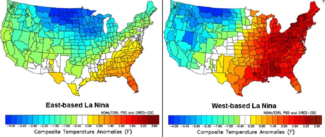
Looks to be a tad east based
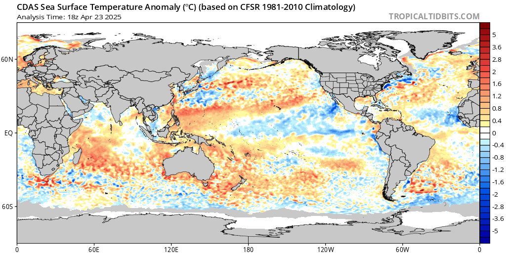
Colder pockets more east developing - but it is a more volatile region for swings
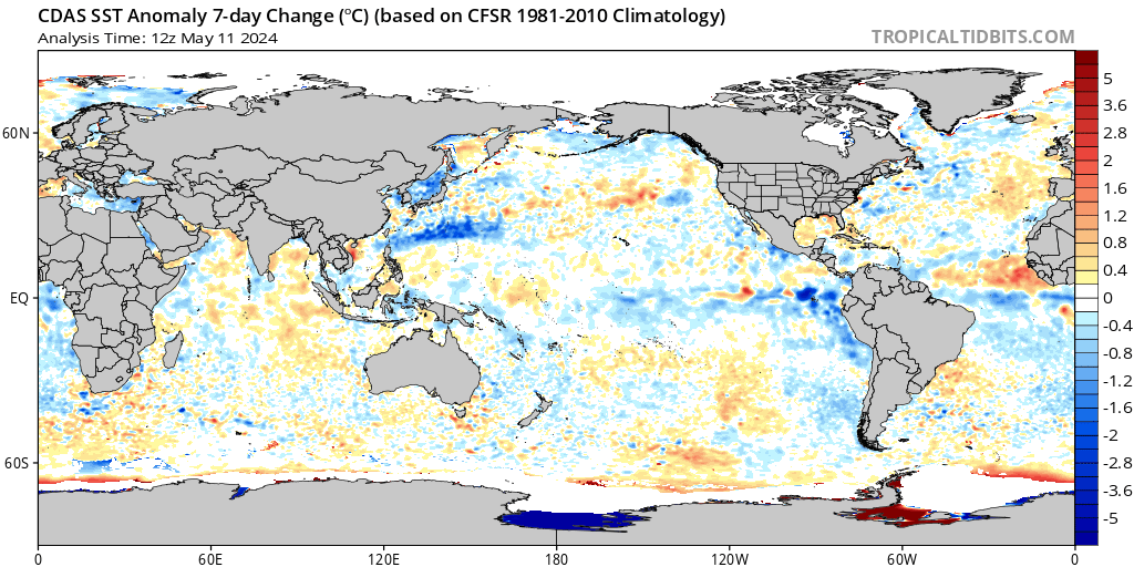
3.4 Moderate Nina for sure
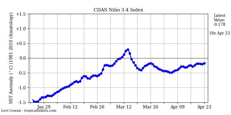
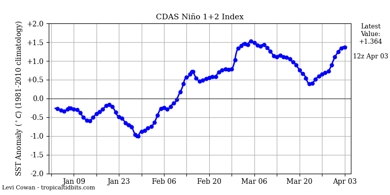
1.2
about equal to 3.4
Cold pocket pushing a bit east as well
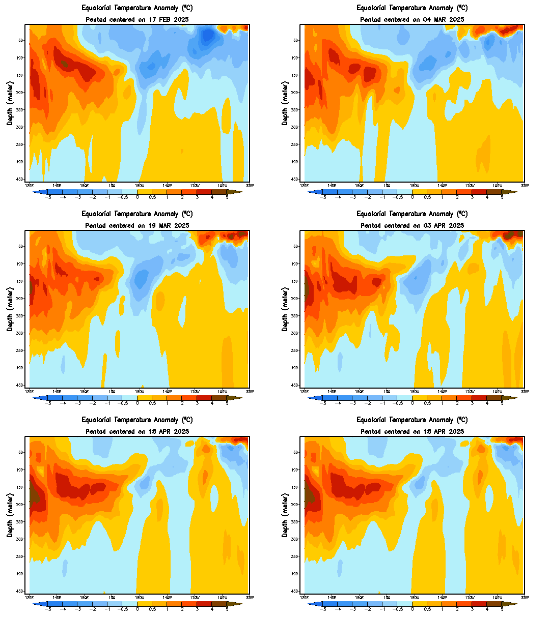

Looks to be a tad east based

Colder pockets more east developing - but it is a more volatile region for swings

3.4 Moderate Nina for sure

1.2
about equal to 3.4

Cold pocket pushing a bit east as well

_________________
Mugs
AKA:King: Snow Weenie
Self Proclaimed
WINTER 2014-15 : 55.12" +.02 for 6 coatings (avg. 35")
WINTER 2015-16 Total - 29.8" (Avg 35")
WINTER 2016-17 : 39.5" so far

amugs- Advanced Forecaster - Mod

- Posts : 15130
Reputation : 213
Join date : 2013-01-07
Age : 54
Location : Hillsdale,NJ
 Re: Long Range Discussion 20(20) (Ha!)
_________________
_______________________________________________________________________________________________________
CLICK HERE to view NJ Strong Snowstorm Classifications
 Re: Long Range Discussion 20(20) (Ha!)
Dunnzoo wrote:Janice Huff's take:
https://www.nbcnewyork.com/weather/less-snow-not-as-cold-storm-team-4s-2020-2021-winter-outlook/2743751/
Meh, boring!
_________________
_______________________________________________________________________________________________________
CLICK HERE to view NJ Strong Snowstorm Classifications
rb924119- Meteorologist

- Posts : 7033
Reputation : 195
Join date : 2013-02-06
Age : 32
Location : Greentown, Pa
 Re: Long Range Discussion 20(20) (Ha!)
Frank_Wx wrote:rb924119 wrote:Frank, always good to see you back at your rightful helm!! However, I am going to continue to respectfully disagree, though I will not be able to go into detail until probably Thanksgiving. That said, I’ve made some of my basic points already, but fully intend to tie them together with respect to the maps.
Hi rb! Hope you are well.
Curious, which part of my post are you disagreeing with? The short-term pattern evolution into early December or the long range overall winter prospects? Or both!
I like your overall winter aspects quite a bit, actually; I strongly agree an overall mild and snow-starved winter for us here is most likely, if I had to forecast, would go with that. However, it is with your medium and extended ranges (next couple of weeks) that I find myself in (respectful) disagreement. Unfortunately, I do not have the time this evening to sit down a write up my discussion, but as I said the other day, I fully intend to take the time to sit down and link a few of my recent posts together into a more coherent dissertation as to why I truly believe this pattern is going to disappoint. That discussion will very likely come sometime on Thursday, so hopefully it’ll make for some good pre-bedtime reading after all of the food haha bit of a tease here, but you’ve gotta follow your ridging and think about what it means at the surface
rb924119- Meteorologist

- Posts : 7033
Reputation : 195
Join date : 2013-02-06
Age : 32
Location : Greentown, Pa
sroc4 likes this post
 Re: Long Range Discussion 20(20) (Ha!)
_________________
"In weather and in life, there's no winning and losing; there's only winning and learning."
WINTER 2012/2013 TOTALS 43.65"WINTER 2017/2018 TOTALS 62.85" WINTER 2022/2023 TOTALS 4.9"
WINTER 2013/2014 TOTALS 64.85"WINTER 2018/2019 TOTALS 14.25" WINTER 2023/2024 TOTALS 13.1"
WINTER 2014/2015 TOTALS 71.20"WINTER 2019/2020 TOTALS 6.35"
WINTER 2015/2016 TOTALS 35.00"WINTER 2020/2021 TOTALS 37.75"
WINTER 2016/2017 TOTALS 42.25"WINTER 2021/2022 TOTALS 31.65"

sroc4- Admin

- Posts : 8441
Reputation : 302
Join date : 2013-01-07
Location : Wading River, LI
 Re: Long Range Discussion 20(20) (Ha!)
Shouldn't wine talk be in the Banter thread...? 

HectorO- Pro Enthusiast

- Posts : 971
Reputation : 27
Join date : 2013-01-11
 Re: Long Range Discussion 20(20) (Ha!)
rb924119 wrote:Frank_Wx wrote:rb924119 wrote:Frank, always good to see you back at your rightful helm!! However, I am going to continue to respectfully disagree, though I will not be able to go into detail until probably Thanksgiving. That said, I’ve made some of my basic points already, but fully intend to tie them together with respect to the maps.
Hi rb! Hope you are well.
Curious, which part of my post are you disagreeing with? The short-term pattern evolution into early December or the long range overall winter prospects? Or both!
I like your overall winter aspects quite a bit, actually; I strongly agree an overall mild and snow-starved winter for us here is most likely, if I had to forecast, would go with that. However, it is with your medium and extended ranges (next couple of weeks) that I find myself in (respectful) disagreement. Unfortunately, I do not have the time this evening to sit down a write up my discussion, but as I said the other day, I fully intend to take the time to sit down and link a few of my recent posts together into a more coherent dissertation as to why I truly believe this pattern is going to disappoint. That discussion will very likely come sometime on Thursday, so hopefully it’ll make for some good pre-bedtime reading after all of the food haha bit of a tease here, but you’ve gotta follow your ridging and think about what it means at the surfacethat’s all I will offer right now, but again, am already mentally constructing my write-up for Thursday
Looking forward to it!
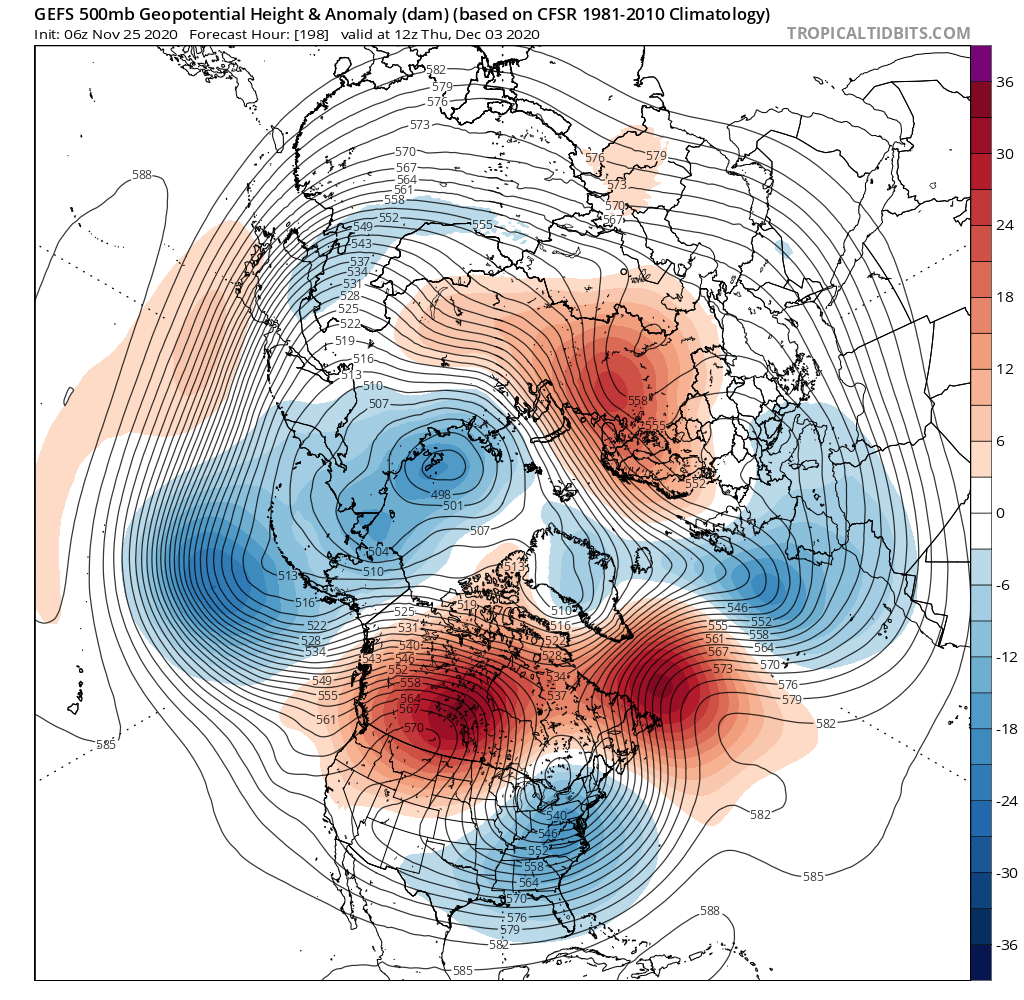
I went back and read my post, and the only thing I’m truly confident in is the pattern flipping to start out the new month. To be clear, I’m not forecasting snow but merely pointing out it is a possibility with the cold air accompanying the pattern change. As of this morning, guidance is still insisting on a +PNA/+EPO developing.
_________________
_______________________________________________________________________________________________________
CLICK HERE to view NJ Strong Snowstorm Classifications
 Re: Long Range Discussion 20(20) (Ha!)
HectorO wrote:Shouldn't wine talk be in the Banter thread...?
Yes, all alcoholics to the banter thread!
_________________
_______________________________________________________________________________________________________
CLICK HERE to view NJ Strong Snowstorm Classifications
 Re: Long Range Discussion 20(20) (Ha!)
_________________
Mugs
AKA:King: Snow Weenie
Self Proclaimed
WINTER 2014-15 : 55.12" +.02 for 6 coatings (avg. 35")
WINTER 2015-16 Total - 29.8" (Avg 35")
WINTER 2016-17 : 39.5" so far

amugs- Advanced Forecaster - Mod

- Posts : 15130
Reputation : 213
Join date : 2013-01-07
Age : 54
Location : Hillsdale,NJ
 Re: Long Range Discussion 20(20) (Ha!)
Morning and Happy Thanksgiving to all a lot of interesting stuff today with regards to the upcoming pattern for December and onwards. It hasn't looked this good for years now and obviously it's still has to verify but there is growing consensus on all guidance of a very favorable pattern change for snow and cold lovers here in the east. Positive PNA signs of a negative AO and negative Nao showing up on guidance through the first half of December. Haven't seen that trifecta in a while which should bring wintry storm chances to our area through the first half of December. Mjo extremely interesting. the Euro basically had it in The Circle of Death for the next month the GFS wants to bring it into 4 5 and 6 today's GFS has it missing 4 heading into 5. The significance of this is if the GFS is correct it will probably cause an Aleutian High Poleward which should disrupt the polar vortex and weaken it as we head towards January as you know it's extremely strong right now also the wave should continue and head through 7/8 and 1 by the time we get to January which could promote very cold and stormy January we'll see how this involves. Also about the polar vortex numerous Mets this morning have stated that long range CVS2 guidance suggest a rapid weakening of the polar vortex late December which would also promote a colder January. If everything holds many Winter forecast will be in jeopardy and this moderate to Strong nina will behave nothing like it interesting times ahead.
James Peacock
@peacockreports
(1/2) This surprisingly strong +EAMT has raised my eyebrows for other reasons too: It could set in motion a series of events that perturb the #PolarVortex in the stratosphere, raising potential for a dramatic weakening event (sudden stratospheric warming) some 4-6 weeks from now.
Matt Hugo
@MattHugo81
Plenty of interesting 'goings on': The +EAMT doing its 'thing' now, note the spike in AAM tendancy this likely to be aided by the MJO moving into phases 4-5-6 looking ahead. Decent wave 2 'attack' on the strat as well still forecast. All places emphasis on more blocked patterns.
Simon Lee
@SimonLeeWx
Some continuing suggestions from extended-range models of a weakening trend in the stratospheric vortex mid-December. Today's CFSv2 has 3 members going for a major SSW in January, but more importantly a below-average mean. Eagerly awaiting tonight's ECMWF extended-range!

algae888- Advanced Forecaster

- Posts : 5311
Reputation : 46
Join date : 2013-02-05
Age : 62
Location : mt. vernon, new york
 Re: Long Range Discussion 20(20) (Ha!)
Forgot to add in the discussion about the EPO
Eric Webb
@webberweather
Already starting to see hints of the aforementioned potential -EPO on the GEFS & EPS as we near mid-Dec. Highly amplified planetary waves like this, esp when they're over the N Pacific, where the jet stream is zonal asymmetric, love to retrograde westward (planetary vort adv).
Eric Webb
@webberweather
Classic positive E Asia Mtn Torque (+EAMT) being shown here as a cold sfc high descends into China. +EAMT signals strong/extensive N Pac jet & enhanced W Pac convection in early Dec >> NINO-ish pattern in N America, perhaps eventually morphing to -EPO (as @antmasiello alluded to)
Eric Webb
@webberweather
Already starting to see hints of the aforementioned potential -EPO on the GEFS & EPS as we near mid-Dec. Highly amplified planetary waves like this, esp when they're over the N Pacific, where the jet stream is zonal asymmetric, love to retrograde westward (planetary vort adv).
Eric Webb
@webberweather
Classic positive E Asia Mtn Torque (+EAMT) being shown here as a cold sfc high descends into China. +EAMT signals strong/extensive N Pac jet & enhanced W Pac convection in early Dec >> NINO-ish pattern in N America, perhaps eventually morphing to -EPO (as @antmasiello alluded to)

algae888- Advanced Forecaster

- Posts : 5311
Reputation : 46
Join date : 2013-02-05
Age : 62
Location : mt. vernon, new york
 Re: Long Range Discussion 20(20) (Ha!)
Thanks Al for posting those
People in the weather works are getting excited about December’s pattern. I am too! But not sold on any significant snow just yet
People in the weather works are getting excited about December’s pattern. I am too! But not sold on any significant snow just yet
_________________
_______________________________________________________________________________________________________
CLICK HERE to view NJ Strong Snowstorm Classifications
Page 4 of 30 •  1, 2, 3, 4, 5 ... 17 ... 30
Page 4 of 30
Permissions in this forum:
You cannot reply to topics in this forum|
|
|

 Home
Home