
 Search
December 2020 Observations and Discussion
Page 2 of 11 •  1, 2, 3, ... 9, 10, 11
 ![]()
Re: December 2020 Observations and Discussion
![]() by jmanley32 Wed Dec 02, 2020 5:43 pm
by jmanley32 Wed Dec 02, 2020 5:43 pm
jmanley32- Senior Enthusiast

- Posts : 20535
Join date : 2013-12-12
Re: December 2020 Observations and Discussion
![]() by jmanley32 Wed Dec 02, 2020 5:44 pm
by jmanley32 Wed Dec 02, 2020 5:44 pm
lol love that scene she said 1:1000000 so ya I guess that's pur chances lol. Prolly better than that.sroc4 wrote:ULL passes south of LI with No Phase = No Chance
ULL passes south of LI with Phase =

jmanley32- Senior Enthusiast
- Posts : 20535
Join date : 2013-12-12
sroc4 likes this post
Re: December 2020 Observations and Discussion
![]() by Frank_Wx Wed Dec 02, 2020 10:57 pm
by Frank_Wx Wed Dec 02, 2020 10:57 pm

_________________
_______________________________________________________________________________________________________
CLICK HERE to view NJ Strong Snowstorm Classifications

Frank_Wx- Godzilla Seeker

- Posts : 21305
Reputation : 328
Join date : 2013-01-05
Age : 32
Location : Jersey City, NJ -

Re: December 2020 Observations and Discussion
![]() by Frank_Wx Wed Dec 02, 2020 10:59 pm
by Frank_Wx Wed Dec 02, 2020 10:59 pm

_________________
_______________________________________________________________________________________________________
CLICK HERE to view NJ Strong Snowstorm Classifications
Frank_Wx- Godzilla Seeker
- Posts : 21305
Reputation : 328
Join date : 2013-01-05
Age : 32
Location : Jersey City, NJ -
Re: December 2020 Observations and Discussion
![]() by Frank_Wx Wed Dec 02, 2020 11:09 pm
by Frank_Wx Wed Dec 02, 2020 11:09 pm

_________________
_______________________________________________________________________________________________________
CLICK HERE to view NJ Strong Snowstorm Classifications
Frank_Wx- Godzilla Seeker
- Posts : 21305
Reputation : 328
Join date : 2013-01-05
Age : 32
Location : Jersey City, NJ -
Re: December 2020 Observations and Discussion
![]() by Frank_Wx Wed Dec 02, 2020 11:13 pm
by Frank_Wx Wed Dec 02, 2020 11:13 pm
brownie wrote:I had some big snowflakes here early this morning. Not enough to stick, but it was nice to see. I could really use some snow right now. Any snow. I’d even settle for a dusting.
Me too....
_________________
_______________________________________________________________________________________________________
CLICK HERE to view NJ Strong Snowstorm Classifications
Frank_Wx- Godzilla Seeker
- Posts : 21305
Reputation : 328
Join date : 2013-01-05
Age : 32
Location : Jersey City, NJ -
Re: December 2020 Observations and Discussion
![]() by Dunnzoo Wed Dec 02, 2020 11:33 pm
by Dunnzoo Wed Dec 02, 2020 11:33 pm
_________________
Janet
Snowfall winter of 2023-2024 17.5"
Snowfall winter of 2022-2023 6.0"
Snowfall winter of 2021-2022 17.6" 1" sleet 2/25/22
Snowfall winter of 2020-2021 51.1"
Snowfall winter of 2019-2020 8.5"
Snowfall winter of 2018-2019 25.1"
Snowfall winter of 2017-2018 51.9"
Snowfall winter of 2016-2017 45.6"
Snowfall winter of 2015-2016 29.5"
Snowfall winter of 2014-2015 50.55"
Snowfall winter of 2013-2014 66.5"

Dunnzoo- Senior Enthusiast - Mod

- Posts : 4905
Reputation : 68
Join date : 2013-01-11
Age : 62
Location : Westwood, NJ
Re: December 2020 Observations and Discussion
![]() by Frank_Wx Thu Dec 03, 2020 7:36 am
by Frank_Wx Thu Dec 03, 2020 7:36 am
Dunnzoo wrote:Anytime it is "phase or no phase", it seems to miss the phase more often than not. Everything has to go just right for anyone in the eastern half of NJ and the Hudson Valley on east to see any snow. I know the GFS is starting to come around, but I'm not expecting anything but a good rain storm at this point. But then again, it's 2020, so who knows!
A full phase would just mean heavier rain for us. There’s no scenario that would bring accumulating snow to the coast. The phase would help those N&W of NYC to see some snow
_________________
_______________________________________________________________________________________________________
CLICK HERE to view NJ Strong Snowstorm Classifications
Frank_Wx- Godzilla Seeker
- Posts : 21305
Reputation : 328
Join date : 2013-01-05
Age : 32
Location : Jersey City, NJ -
Re: December 2020 Observations and Discussion
![]() by heehaw453 Thu Dec 03, 2020 7:41 am
by heehaw453 Thu Dec 03, 2020 7:41 am
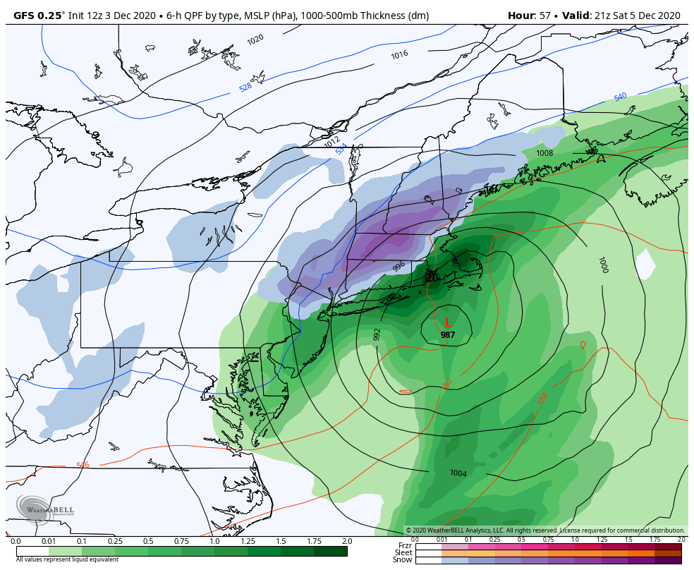
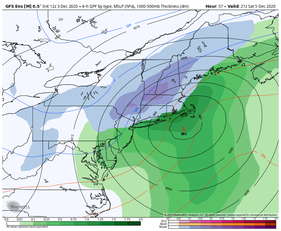
Regardless of the solution surface temperatures are well above freezing.
Just based on past experience I'd say flakes will be seen but the best chance for snow accumulations > 3" are interior New England especially the higher elevations. That certainly doesn't mean the NW folks won't see some accumulations. The temperatures and timing of the phase are a problem.
heehaw453- Advanced Forecaster

- Posts : 3906
Reputation : 86
Join date : 2014-01-20
Location : Bedminster Township, PA Elevation 600' ASL
Re: December 2020 Observations and Discussion
![]() by phil155 Thu Dec 03, 2020 10:02 am
by phil155 Thu Dec 03, 2020 10:02 am
phil155- Pro Enthusiast

- Posts : 483
Reputation : 4
Join date : 2019-12-16
Re: December 2020 Observations and Discussion
![]() by sroc4 Thu Dec 03, 2020 10:02 am
by sroc4 Thu Dec 03, 2020 10:02 am
Frank_Wx wrote:Dunnzoo wrote:Anytime it is "phase or no phase", it seems to miss the phase more often than not. Everything has to go just right for anyone in the eastern half of NJ and the Hudson Valley on east to see any snow. I know the GFS is starting to come around, but I'm not expecting anything but a good rain storm at this point. But then again, it's 2020, so who knows!
A full phase would just mean heavier rain for us. There’s no scenario that would bring accumulating snow to the coast. The phase would help those N&W of NYC to see some snow
While it is unlikely there are def scenarios for accumulating on or areound the coast Frank. 12 NAM case in point. That phases just right in that location at that time. Its baby bear....juuuussst right. Does that happen verbatim??? odds are no. But there is a way
_________________
"In weather and in life, there's no winning and losing; there's only winning and learning."
WINTER 2012/2013 TOTALS 43.65"WINTER 2017/2018 TOTALS 62.85" WINTER 2022/2023 TOTALS 4.9"
WINTER 2013/2014 TOTALS 64.85"WINTER 2018/2019 TOTALS 14.25" WINTER 2023/2024 TOTALS 13.1"
WINTER 2014/2015 TOTALS 71.20"WINTER 2019/2020 TOTALS 6.35"
WINTER 2015/2016 TOTALS 35.00"WINTER 2020/2021 TOTALS 37.75"
WINTER 2016/2017 TOTALS 42.25"WINTER 2021/2022 TOTALS 31.65"

sroc4- Admin
- Posts : 8354
Reputation : 302
Join date : 2013-01-07
Location : Wading River, LI
Re: December 2020 Observations and Discussion
![]() by amugs Thu Dec 03, 2020 10:47 am
by amugs Thu Dec 03, 2020 10:47 am
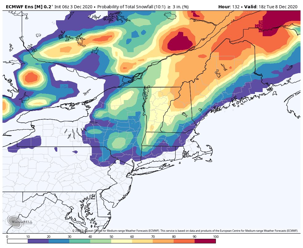
GEFS
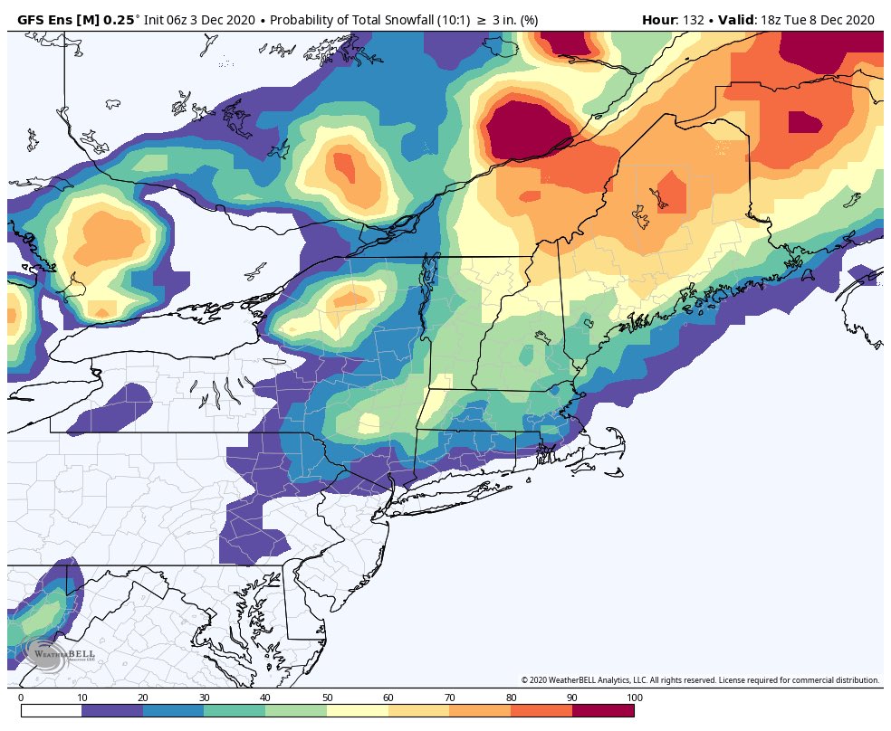
EURO
_________________
Mugs
AKA:King: Snow Weenie
Self Proclaimed
WINTER 2014-15 : 55.12" +.02 for 6 coatings (avg. 35")
WINTER 2015-16 Total - 29.8" (Avg 35")
WINTER 2016-17 : 39.5" so far

amugs- Advanced Forecaster - Mod
- Posts : 15095
Reputation : 213
Join date : 2013-01-07
Age : 54
Location : Hillsdale,NJ
Re: December 2020 Observations and Discussion
![]() by sroc4 Thu Dec 03, 2020 11:11 am
by sroc4 Thu Dec 03, 2020 11:11 am
_________________
"In weather and in life, there's no winning and losing; there's only winning and learning."
WINTER 2012/2013 TOTALS 43.65"WINTER 2017/2018 TOTALS 62.85" WINTER 2022/2023 TOTALS 4.9"
WINTER 2013/2014 TOTALS 64.85"WINTER 2018/2019 TOTALS 14.25" WINTER 2023/2024 TOTALS 13.1"
WINTER 2014/2015 TOTALS 71.20"WINTER 2019/2020 TOTALS 6.35"
WINTER 2015/2016 TOTALS 35.00"WINTER 2020/2021 TOTALS 37.75"
WINTER 2016/2017 TOTALS 42.25"WINTER 2021/2022 TOTALS 31.65"
sroc4- Admin
- Posts : 8354
Reputation : 302
Join date : 2013-01-07
Location : Wading River, LI
Re: December 2020 Observations and Discussion
![]() by amugs Thu Dec 03, 2020 11:49 am
by amugs Thu Dec 03, 2020 11:49 am
The anomalous warm waters off the coast are not help at all. Need that HP stronger as I said yesterday.
27* for my low last night. Had that winter feel for sure.
_________________
Mugs
AKA:King: Snow Weenie
Self Proclaimed
WINTER 2014-15 : 55.12" +.02 for 6 coatings (avg. 35")
WINTER 2015-16 Total - 29.8" (Avg 35")
WINTER 2016-17 : 39.5" so far
amugs- Advanced Forecaster - Mod
- Posts : 15095
Reputation : 213
Join date : 2013-01-07
Age : 54
Location : Hillsdale,NJ
Re: December 2020 Observations and Discussion
![]() by amugs Thu Dec 03, 2020 1:14 pm
by amugs Thu Dec 03, 2020 1:14 pm
GEFS say yes to the operational
_________________
Mugs
AKA:King: Snow Weenie
Self Proclaimed
WINTER 2014-15 : 55.12" +.02 for 6 coatings (avg. 35")
WINTER 2015-16 Total - 29.8" (Avg 35")
WINTER 2016-17 : 39.5" so far
amugs- Advanced Forecaster - Mod
- Posts : 15095
Reputation : 213
Join date : 2013-01-07
Age : 54
Location : Hillsdale,NJ
Re: December 2020 Observations and Discussion
![]() by heehaw453 Thu Dec 03, 2020 1:43 pm
by heehaw453 Thu Dec 03, 2020 1:43 pm
sroc4 wrote:Frank_Wx wrote:Dunnzoo wrote:Anytime it is "phase or no phase", it seems to miss the phase more often than not. Everything has to go just right for anyone in the eastern half of NJ and the Hudson Valley on east to see any snow. I know the GFS is starting to come around, but I'm not expecting anything but a good rain storm at this point. But then again, it's 2020, so who knows!
A full phase would just mean heavier rain for us. There’s no scenario that would bring accumulating snow to the coast. The phase would help those N&W of NYC to see some snow
While it is unlikely there are def scenarios for accumulating on or areound the coast Frank. 12 NAM case in point. That phases just right in that location at that time. Its baby bear....juuuussst right. Does that happen verbatim??? odds are no. But there is a way
Sroc Benchmark track seems more and more likely. If this thing bombs right you're getting some CCB paste in your neck of the woods. The 12Z Euro was pretty damn close for the North Shore.
heehaw453- Advanced Forecaster
- Posts : 3906
Reputation : 86
Join date : 2014-01-20
Location : Bedminster Township, PA Elevation 600' ASL
Re: December 2020 Observations and Discussion
![]() by Frank_Wx Thu Dec 03, 2020 4:01 pm
by Frank_Wx Thu Dec 03, 2020 4:01 pm
_________________
_______________________________________________________________________________________________________
CLICK HERE to view NJ Strong Snowstorm Classifications
Frank_Wx- Godzilla Seeker
- Posts : 21305
Reputation : 328
Join date : 2013-01-05
Age : 32
Location : Jersey City, NJ -
Re: December 2020 Observations and Discussion
![]() by jmanley32 Thu Dec 03, 2020 4:06 pm
by jmanley32 Thu Dec 03, 2020 4:06 pm
Don't care, if I see snowflakes falling it will put somewhat of a better mood on for this aweful year, stay safe eveyone, the US saw the most COVID deaths ever in the pandemic yesterday at 3,100.Frank_Wx wrote:Want to stress accumulating in my statement...backend snow for the coast is possible but nothing in terms of accumulating. N&W is still in the game for some, though!

jmanley32- Senior Enthusiast
- Posts : 20535
Reputation : 108
Join date : 2013-12-12
Age : 43
Location : Yonkers, NY
Re: December 2020 Observations and Discussion
![]() by amugs Thu Dec 03, 2020 4:20 pm
by amugs Thu Dec 03, 2020 4:20 pm
I'll take it and run Frank didn't you work for Bobby at one point?
_________________
Mugs
AKA:King: Snow Weenie
Self Proclaimed
WINTER 2014-15 : 55.12" +.02 for 6 coatings (avg. 35")
WINTER 2015-16 Total - 29.8" (Avg 35")
WINTER 2016-17 : 39.5" so far
amugs- Advanced Forecaster - Mod
- Posts : 15095
Reputation : 213
Join date : 2013-01-07
Age : 54
Location : Hillsdale,NJ
Re: December 2020 Observations and Discussion
![]() by aiannone Thu Dec 03, 2020 4:22 pm
by aiannone Thu Dec 03, 2020 4:22 pm
With a deepening low and nly component flow locking in however,
temps in the column should support snow as they wet bulb. The models
in fact all show the h925 to h7 layer cooling to blw freezing in the
deformation zone, even down to the coast.
BL temps will be toughest near the coast, especially LI with flow
off the water. Elsewhere, without any onshore component, it seems
likely that the cooling would be sufficient to support a changeover
during the day on Sat. This is what the fcst indicates.
_________________
-Alex Iannone-

aiannone- Senior Enthusiast - Mod
- Posts : 4815
Reputation : 92
Join date : 2013-01-07
Location : Saint James, LI (Northwest Suffolk Co.)
Re: December 2020 Observations and Discussion
![]() by billg315 Thu Dec 03, 2020 4:23 pm
by billg315 Thu Dec 03, 2020 4:23 pm

billg315- Advanced Forecaster - Mod
- Posts : 4483
Reputation : 185
Join date : 2015-01-24
Age : 50
Location : Flemington, NJ
Re: December 2020 Observations and Discussion
![]() by amugs Thu Dec 03, 2020 4:25 pm
by amugs Thu Dec 03, 2020 4:25 pm
_________________
Mugs
AKA:King: Snow Weenie
Self Proclaimed
WINTER 2014-15 : 55.12" +.02 for 6 coatings (avg. 35")
WINTER 2015-16 Total - 29.8" (Avg 35")
WINTER 2016-17 : 39.5" so far
amugs- Advanced Forecaster - Mod
- Posts : 15095
Reputation : 213
Join date : 2013-01-07
Age : 54
Location : Hillsdale,NJ
Re: December 2020 Observations and Discussion
![]() by Frank_Wx Thu Dec 03, 2020 5:09 pm
by Frank_Wx Thu Dec 03, 2020 5:09 pm
amugs wrote:
I'll take it and run Frank didn't you work for Bobby at one point?
Yup! Pretty bullish let’s see how it goes
_________________
_______________________________________________________________________________________________________
CLICK HERE to view NJ Strong Snowstorm Classifications
Frank_Wx- Godzilla Seeker
- Posts : 21305
Reputation : 328
Join date : 2013-01-05
Age : 32
Location : Jersey City, NJ -
Re: December 2020 Observations and Discussion
![]() by sroc4 Thu Dec 03, 2020 5:17 pm
by sroc4 Thu Dec 03, 2020 5:17 pm
amugs wrote:
I'll take it and run Frank didn't you work for Bobby at one point?
This is Steve Dimartino...NOT Bobby M. If it were Bobby Id listen. Since its SD I wont
_________________
"In weather and in life, there's no winning and losing; there's only winning and learning."
WINTER 2012/2013 TOTALS 43.65"WINTER 2017/2018 TOTALS 62.85" WINTER 2022/2023 TOTALS 4.9"
WINTER 2013/2014 TOTALS 64.85"WINTER 2018/2019 TOTALS 14.25" WINTER 2023/2024 TOTALS 13.1"
WINTER 2014/2015 TOTALS 71.20"WINTER 2019/2020 TOTALS 6.35"
WINTER 2015/2016 TOTALS 35.00"WINTER 2020/2021 TOTALS 37.75"
WINTER 2016/2017 TOTALS 42.25"WINTER 2021/2022 TOTALS 31.65"
sroc4- Admin
- Posts : 8354
Reputation : 302
Join date : 2013-01-07
Location : Wading River, LI
Re: December 2020 Observations and Discussion
![]() by amugs Thu Dec 03, 2020 5:24 pm
by amugs Thu Dec 03, 2020 5:24 pm
sroc4 wrote:amugs wrote:
I'll take it and run Frank didn't you work for Bobby at one point?
This is Steve Dimartino...NOT Bobby M. If it were Bobby Id listen. Since its SD I wont
Oh yes that is correct I get them mixed up EPANJ WX and this one
_________________
Mugs
AKA:King: Snow Weenie
Self Proclaimed
WINTER 2014-15 : 55.12" +.02 for 6 coatings (avg. 35")
WINTER 2015-16 Total - 29.8" (Avg 35")
WINTER 2016-17 : 39.5" so far
amugs- Advanced Forecaster - Mod
- Posts : 15095
Reputation : 213
Join date : 2013-01-07
Age : 54
Location : Hillsdale,NJ
Re: December 2020 Observations and Discussion
![]() by amugs Thu Dec 03, 2020 5:25 pm
by amugs Thu Dec 03, 2020 5:25 pm

_________________
Mugs
AKA:King: Snow Weenie
Self Proclaimed
WINTER 2014-15 : 55.12" +.02 for 6 coatings (avg. 35")
WINTER 2015-16 Total - 29.8" (Avg 35")
WINTER 2016-17 : 39.5" so far
amugs- Advanced Forecaster - Mod
- Posts : 15095
Reputation : 213
Join date : 2013-01-07
Age : 54
Location : Hillsdale,NJ
Re: December 2020 Observations and Discussion
![]() by amugs Thu Dec 03, 2020 7:50 pm
by amugs Thu Dec 03, 2020 7:50 pm
_________________
Mugs
AKA:King: Snow Weenie
Self Proclaimed
WINTER 2014-15 : 55.12" +.02 for 6 coatings (avg. 35")
WINTER 2015-16 Total - 29.8" (Avg 35")
WINTER 2016-17 : 39.5" so far
amugs- Advanced Forecaster - Mod
- Posts : 15095
Reputation : 213
Join date : 2013-01-07
Age : 54
Location : Hillsdale,NJ
Page 2 of 11 • 1, 2, 3, ... 9, 10, 11 ![]()
|
|
|