
 Search
December 2020 Observations and Discussion
Page 3 of 11 •  1, 2, 3, 4 ... 9, 10, 11
 ![]()
Re: December 2020 Observations and Discussion
![]() by amugs Thu Dec 03, 2020 7:25 pm
by amugs Thu Dec 03, 2020 7:25 pm

amugs- Advanced Forecaster - Mod

- Posts : 15095
Join date : 2013-01-07
Re: December 2020 Observations and Discussion
![]() by amugs Thu Dec 03, 2020 9:50 pm
by amugs Thu Dec 03, 2020 9:50 pm
amugs- Advanced Forecaster - Mod
- Posts : 15095
Join date : 2013-01-07
Re: December 2020 Observations and Discussion
![]() by jmanley32 Thu Dec 03, 2020 10:37 pm
by jmanley32 Thu Dec 03, 2020 10:37 pm
I love it, I am picturing mugs screaming this at us the entire time, good post. We will see what happens.amugs wrote:THERE IS A LOT OF UNCERTAINTY WITH THE THE STORM SYS FOR SAT. THE 12Z MODELS ALL SUGGESTED THAT DEEPENING LOW PRES WOULD TRACK JUST SOUTH AND EAST OF THE AREA, PASSING NEAR CAPE COD ABOUT 00Z SUN. EVEN THIS CONSENSUS HAS BEEN SHORT LIVED HOWEVER, AS THE 18Z NAM HAS COME IN SIGNIFICANTLY SOUTH OF THIS CLUSTERING. WHAT IS RELATIVELY CERTAIN IS THAT WITH A LACK OF COLD AIR IN PLACE, ANY SNOW WILL BE ON THE BACK SIDE OF THE SYS. THE 12Z RUNS OF THE GFS, NAM AND ECMWF ALL SUPPORTED THIS NOTION, BUT STILL TEMPS ARE MARGINAL AT BEST IF LOOKING AT THE RAW MODEL SFC DATA AND GUIDANCE. WITH A DEEPENING LOW AND NLY COMPONENT FLOW LOCKING IN HOWEVER, TEMPS IN THE COLUMN SHOULD SUPPORT SNOW AS THEY WET BULB. THE MODELS IN FACT ALL SHOW THE H925 TO H7 LAYER COOLING TO BLW FREEZING IN THE DEFORMATION ZONE, EVEN DOWN TO THE COAST. BL TEMPS WILL BE TOUGHEST NEAR THE COAST, ESPECIALLY LI WITH FLOW OFF THE WATER. ELSEWHERE, WITHOUT ANY ONSHORE COMPONENT, IT SEEMS LIKELY THAT THE COOLING WOULD BE SUFFICIENT TO SUPPORT A CHANGEOVER DURING THE DAY ON SAT. THIS IS WHAT THE FCST INDICATES. A FEW INCHES HAS BEEN FCST FOR THE INTERIOR, WITH THE HIGHER ELEVATIONS OF WRN CT TO NE NJ FAVORED. LESSER AMOUNTS SOUTH AND EAST OF THIS AREA. SNOW GRAPHICS AND SNOW PROBS HAVE BEEN UPLOADED TO THE WEB.

jmanley32- Senior Enthusiast

- Posts : 20535
Reputation : 108
Join date : 2013-12-13
Age : 43
Location : Yonkers, NY
Re: December 2020 Observations and Discussion
![]() by hyde345 Thu Dec 03, 2020 11:01 pm
by hyde345 Thu Dec 03, 2020 11:01 pm

hyde345- Pro Enthusiast

- Posts : 1082
Reputation : 48
Join date : 2013-01-08
Location : Hyde Park, NY
CPcantmeasuresnow likes this post
Re: December 2020 Observations and Discussion
![]() by jmanley32 Thu Dec 03, 2020 11:25 pm
by jmanley32 Thu Dec 03, 2020 11:25 pm
Most likely but to even be talking about snow on Dec. 3rd is cool, as of recent we havent been tracking much until Jan. Shoot it was 70 in some years around x-mas. I do not think we get that warm, unless I am mistaken.hyde345 wrote:I think this is going to be close but no cigar for most of the region. Even up here in HV I don't see more than a coating. The sweet spot is going to be Central and northern NE. Has CP come out of hibernation yet?
jmanley32- Senior Enthusiast
- Posts : 20535
Reputation : 108
Join date : 2013-12-13
Age : 43
Location : Yonkers, NY
Re: December 2020 Observations and Discussion
![]() by hyde345 Thu Dec 03, 2020 11:53 pm
by hyde345 Thu Dec 03, 2020 11:53 pm
jmanley32 wrote:Most likely but to even be talking about snow on Dec. 3rd is cool, as of recent we havent been tracking much until Jan. Shoot it was 70 in some years around x-mas. I do not think we get that warm, unless I am mistaken.hyde345 wrote:I think this is going to be close but no cigar for most of the region. Even up here in HV I don't see more than a coating. The sweet spot is going to be Central and northern NE. Has CP come out of hibernation yet?
Almost exactly a year ago I picked up 11 inches which was half of my total for the season. Lets hope we all do a little better than last winter. The jury is still out on that though.
hyde345- Pro Enthusiast
- Posts : 1082
Reputation : 48
Join date : 2013-01-08
Location : Hyde Park, NY
CPcantmeasuresnow likes this post
Re: December 2020 Observations and Discussion
![]() by jmanley32 Fri Dec 04, 2020 12:12 am
by jmanley32 Fri Dec 04, 2020 12:12 am
Well that def did not happen IMBY, we got maybe 4 inches all winter with a number of 0.25-1.0 flurries.hyde345 wrote:jmanley32 wrote:Most likely but to even be talking about snow on Dec. 3rd is cool, as of recent we havent been tracking much until Jan. Shoot it was 70 in some years around x-mas. I do not think we get that warm, unless I am mistaken.hyde345 wrote:I think this is going to be close but no cigar for most of the region. Even up here in HV I don't see more than a coating. The sweet spot is going to be Central and northern NE. Has CP come out of hibernation yet?
Almost exactly a year ago I picked up 11 inches which was half of my total for the season. Lets hope we all do a little better than last winter. The jury is still out on that though.
jmanley32- Senior Enthusiast
- Posts : 20535
Reputation : 108
Join date : 2013-12-13
Age : 43
Location : Yonkers, NY
Re: December 2020 Observations and Discussion
![]() by CPcantmeasuresnow Fri Dec 04, 2020 12:37 am
by CPcantmeasuresnow Fri Dec 04, 2020 12:37 am
hyde345 wrote:jmanley32 wrote:Most likely but to even be talking about snow on Dec. 3rd is cool, as of recent we havent been tracking much until Jan. Shoot it was 70 in some years around x-mas. I do not think we get that warm, unless I am mistaken.hyde345 wrote:I think this is going to be close but no cigar for most of the region. Even up here in HV I don't see more than a coating. The sweet spot is going to be Central and northern NE. Has CP come out of hibernation yet?
Almost exactly a year ago I picked up 11 inches which was half of my total for the season. Lets hope we all do a little better than last winter. The jury is still out on that though.
The evening of December 1st last year ice started changing to snow on the second and not ending until the 3rd. We ended up with 12 inches, so you're right on the money with that Hyde. You're also right on the money about it being half of our snowfall for the entire season. Picked up an additional 11.1 inches between December 4th and May 9th. One of the worst Winters ever.

CPcantmeasuresnow- Wx Statistician Guru

- Posts : 7274
Reputation : 230
Join date : 2013-01-08
Age : 103
Location : Eastern Orange County, NY
hyde345 likes this post
Re: December 2020 Observations and Discussion
![]() by aiannone Fri Dec 04, 2020 12:46 am
by aiannone Fri Dec 04, 2020 12:46 am


_________________
-Alex Iannone-

aiannone- Senior Enthusiast - Mod
- Posts : 4815
Reputation : 92
Join date : 2013-01-07
Location : Saint James, LI (Northwest Suffolk Co.)
Re: December 2020 Observations and Discussion
![]() by amugs Fri Dec 04, 2020 12:53 am
by amugs Fri Dec 04, 2020 12:53 am
I have to say this storm will help set up the Monday possibility storm. That one has better potential. This was a cutter LR, OTS now up the coast.
_________________
Mugs
AKA:King: Snow Weenie
Self Proclaimed
WINTER 2014-15 : 55.12" +.02 for 6 coatings (avg. 35")
WINTER 2015-16 Total - 29.8" (Avg 35")
WINTER 2016-17 : 39.5" so far

amugs- Advanced Forecaster - Mod
- Posts : 15095
Reputation : 213
Join date : 2013-01-07
Age : 54
Location : Hillsdale,NJ
Re: December 2020 Observations and Discussion
![]() by jmanley32 Fri Dec 04, 2020 2:43 am
by jmanley32 Fri Dec 04, 2020 2:43 am
For real? over 20 inches? cry me a river CP lol, yeah geographically speaking thats not a good winter.CPcantmeasuresnow wrote:hyde345 wrote:jmanley32 wrote:Most likely but to even be talking about snow on Dec. 3rd is cool, as of recent we havent been tracking much until Jan. Shoot it was 70 in some years around x-mas. I do not think we get that warm, unless I am mistaken.hyde345 wrote:I think this is going to be close but no cigar for most of the region. Even up here in HV I don't see more than a coating. The sweet spot is going to be Central and northern NE. Has CP come out of hibernation yet?
Almost exactly a year ago I picked up 11 inches which was half of my total for the season. Lets hope we all do a little better than last winter. The jury is still out on that though.
The evening of December 1st last year ice started changing to snow on the second and not ending until the 3rd. We ended up with 12 inches, so you're right on the money with that Hyde. You're also right on the money about it being half of our snowfall for the entire season. Picked up an additional 11.1 inches between December 4th and May 9th. One of the worst Winters ever.
jmanley32- Senior Enthusiast
- Posts : 20535
Reputation : 108
Join date : 2013-12-13
Age : 43
Location : Yonkers, NY
CPcantmeasuresnow likes this post
Re: December 2020 Observations and Discussion
![]() by jmanley32 Fri Dec 04, 2020 2:46 am
by jmanley32 Fri Dec 04, 2020 2:46 am
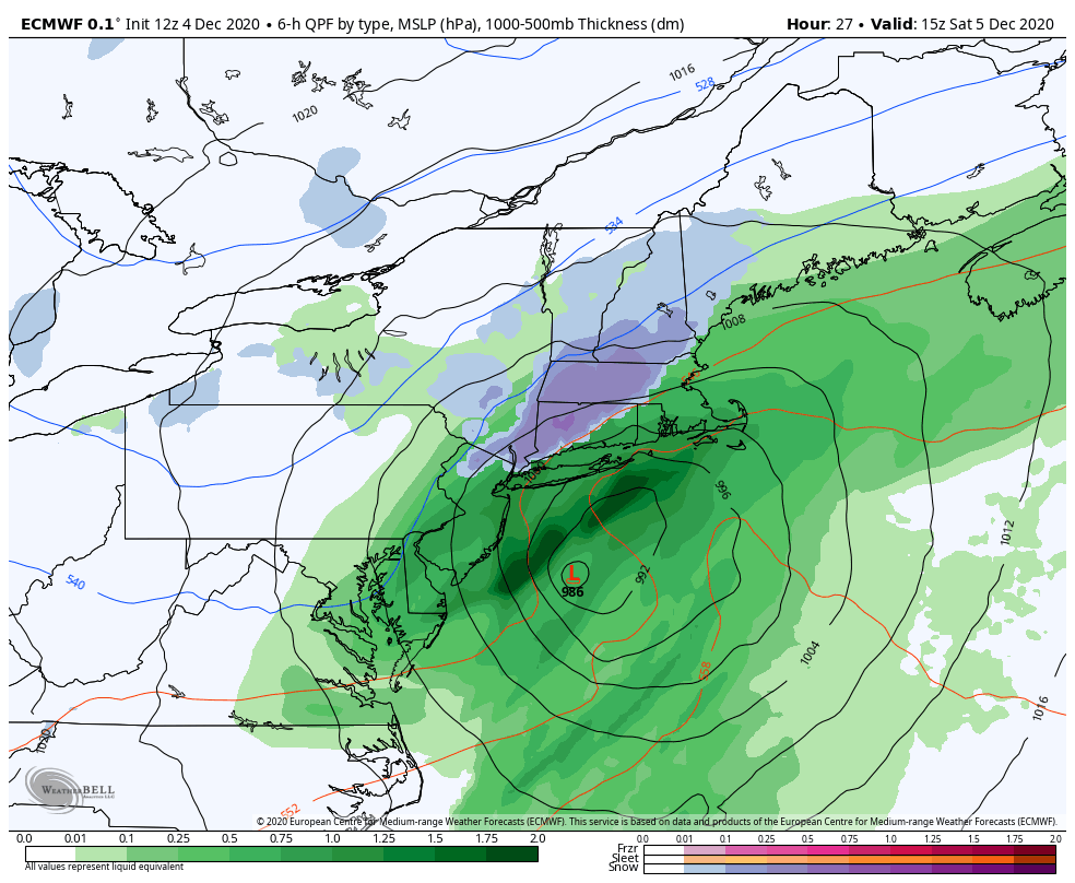
Do you think winds will be a issue with this storm? I noted on the model runs all the winds are on the east side and very strong at that, but sometimes the modeling is off on whats on the other side for some reason. NWS did mention 45mph gusts, which seems safe atm, could see high wind warnings if it comes in stronger. yucky either way, and even I though usually love wind storms, don't really like it if its pouring out cuz i like to be able to be out in it. I love sunny windstorms.amugs wrote:Alex great maps there kid. That 986 means a strong Nor and it should change us over to some backend wet snow since it bombing, phase is just of NJ. Good sign there.
I have to say this storm will help set up the Monday possibility storm. That one has better potential. This was a cutter LR, OTS now up the coast.
jmanley32- Senior Enthusiast
- Posts : 20535
Reputation : 108
Join date : 2013-12-13
Age : 43
Location : Yonkers, NY
Re: December 2020 Observations and Discussion
![]() by sroc4 Fri Dec 04, 2020 7:52 am
by sroc4 Fri Dec 04, 2020 7:52 am
Fun to track though. Cheers!
_________________
"In weather and in life, there's no winning and losing; there's only winning and learning."
WINTER 2012/2013 TOTALS 43.65"WINTER 2017/2018 TOTALS 62.85" WINTER 2022/2023 TOTALS 4.9"
WINTER 2013/2014 TOTALS 64.85"WINTER 2018/2019 TOTALS 14.25" WINTER 2023/2024 TOTALS 13.1"
WINTER 2014/2015 TOTALS 71.20"WINTER 2019/2020 TOTALS 6.35"
WINTER 2015/2016 TOTALS 35.00"WINTER 2020/2021 TOTALS 37.75"
WINTER 2016/2017 TOTALS 42.25"WINTER 2021/2022 TOTALS 31.65"

sroc4- Admin

- Posts : 8354
Reputation : 302
Join date : 2013-01-07
Location : Wading River, LI
rb924119 likes this post
Re: December 2020 Observations and Discussion
![]() by heehaw453 Fri Dec 04, 2020 9:02 am
by heehaw453 Fri Dec 04, 2020 9:02 am
I also think that western NJ, EPA, HV may get < 1" of rain out of this as the bulk of the heavy rain stays SE of those areas.
All things considered though, this really is very close for LI North Shore, so don't be surprised to get some accumulating paste there.
heehaw453- Advanced Forecaster

- Posts : 3906
Reputation : 86
Join date : 2014-01-20
Location : Bedminster Township, PA Elevation 600' ASL
Re: December 2020 Observations and Discussion
![]() by Frank_Wx Fri Dec 04, 2020 12:19 pm
by Frank_Wx Fri Dec 04, 2020 12:19 pm
_________________
_______________________________________________________________________________________________________
CLICK HERE to view NJ Strong Snowstorm Classifications

Frank_Wx- Godzilla Seeker
- Posts : 21305
Reputation : 328
Join date : 2013-01-05
Age : 32
Location : Jersey City, NJ -

rb924119 likes this post
Re: December 2020 Observations and Discussion
![]() by amugs Fri Dec 04, 2020 1:51 pm
by amugs Fri Dec 04, 2020 1:51 pm

_________________
Mugs
AKA:King: Snow Weenie
Self Proclaimed
WINTER 2014-15 : 55.12" +.02 for 6 coatings (avg. 35")
WINTER 2015-16 Total - 29.8" (Avg 35")
WINTER 2016-17 : 39.5" so far
amugs- Advanced Forecaster - Mod
- Posts : 15095
Reputation : 213
Join date : 2013-01-07
Age : 54
Location : Hillsdale,NJ
Re: December 2020 Observations and Discussion
![]() by Frank_Wx Fri Dec 04, 2020 2:34 pm
by Frank_Wx Fri Dec 04, 2020 2:34 pm
Talk about pressure...
To me, looks like it will be close.
_________________
_______________________________________________________________________________________________________
CLICK HERE to view NJ Strong Snowstorm Classifications
Frank_Wx- Godzilla Seeker
- Posts : 21305
Reputation : 328
Join date : 2013-01-05
Age : 32
Location : Jersey City, NJ -
Re: December 2020 Observations and Discussion
![]() by sroc4 Fri Dec 04, 2020 2:35 pm
by sroc4 Fri Dec 04, 2020 2:35 pm
Frank_Wx wrote:I have friends getting married outdoors at 2pm tomorrow. They’re asking me if it will stop raining.
Talk about pressure...
To me, looks like it will be close.
Where Frank? Id bet if they were getting married by me tomorrow it will still be raining
_________________
"In weather and in life, there's no winning and losing; there's only winning and learning."
WINTER 2012/2013 TOTALS 43.65"WINTER 2017/2018 TOTALS 62.85" WINTER 2022/2023 TOTALS 4.9"
WINTER 2013/2014 TOTALS 64.85"WINTER 2018/2019 TOTALS 14.25" WINTER 2023/2024 TOTALS 13.1"
WINTER 2014/2015 TOTALS 71.20"WINTER 2019/2020 TOTALS 6.35"
WINTER 2015/2016 TOTALS 35.00"WINTER 2020/2021 TOTALS 37.75"
WINTER 2016/2017 TOTALS 42.25"WINTER 2021/2022 TOTALS 31.65"
sroc4- Admin
- Posts : 8354
Reputation : 302
Join date : 2013-01-07
Location : Wading River, LI
Re: December 2020 Observations and Discussion
![]() by amugs Fri Dec 04, 2020 2:54 pm
by amugs Fri Dec 04, 2020 2:54 pm
_________________
Mugs
AKA:King: Snow Weenie
Self Proclaimed
WINTER 2014-15 : 55.12" +.02 for 6 coatings (avg. 35")
WINTER 2015-16 Total - 29.8" (Avg 35")
WINTER 2016-17 : 39.5" so far
amugs- Advanced Forecaster - Mod
- Posts : 15095
Reputation : 213
Join date : 2013-01-07
Age : 54
Location : Hillsdale,NJ
Re: December 2020 Observations and Discussion
![]() by sroc4 Fri Dec 04, 2020 3:40 pm
by sroc4 Fri Dec 04, 2020 3:40 pm
heehaw453 wrote:This is definitely not our storm. Like a Miller B normally does it will nail New England with 6"+ of snow. The lack of cold air seals the deal for us, otherwise, it'd be a nice storm even with the late development.
I also think that western NJ, EPA, HV may get < 1" of rain out of this as the bulk of the heavy rain stays SE of those areas.
All things considered though, this really is very close for LI North Shore, so don't be surprised to get some accumulating paste there.
You may be onto something here. Only thing making me hesitate is the low to mid 50's SST in the LI sound and the north wind modifying because of it.
_________________
"In weather and in life, there's no winning and losing; there's only winning and learning."
WINTER 2012/2013 TOTALS 43.65"WINTER 2017/2018 TOTALS 62.85" WINTER 2022/2023 TOTALS 4.9"
WINTER 2013/2014 TOTALS 64.85"WINTER 2018/2019 TOTALS 14.25" WINTER 2023/2024 TOTALS 13.1"
WINTER 2014/2015 TOTALS 71.20"WINTER 2019/2020 TOTALS 6.35"
WINTER 2015/2016 TOTALS 35.00"WINTER 2020/2021 TOTALS 37.75"
WINTER 2016/2017 TOTALS 42.25"WINTER 2021/2022 TOTALS 31.65"
sroc4- Admin
- Posts : 8354
Reputation : 302
Join date : 2013-01-07
Location : Wading River, LI
Re: December 2020 Observations and Discussion
![]() by CPcantmeasuresnow Fri Dec 04, 2020 3:58 pm
by CPcantmeasuresnow Fri Dec 04, 2020 3:58 pm
amugs wrote:Ensembles have snow in LHV and NNJ now - interesting
Not enough of them.
This storm is toast as is this winter. This will make three stinkers in a row, I'll check back in again around the 18th and hope something drastically changes. For now I stick with this motto, the less I follow it, the less it annoys me. After the last two winters it's at least working for me, so far.
CPcantmeasuresnow- Wx Statistician Guru
- Posts : 7274
Reputation : 230
Join date : 2013-01-08
Age : 103
Location : Eastern Orange County, NY
CPcantmeasuresnow and rb924119 like this post
Re: December 2020 Observations and Discussion
![]() by amugs Fri Dec 04, 2020 4:53 pm
by amugs Fri Dec 04, 2020 4:53 pm
CPcantmeasuresnow wrote:amugs wrote:Ensembles have snow in LHV and NNJ now - interesting
Not enough of them.
This storm is toast as is this winter. This will make three stinkers in a row, I'll check back in again around the 18th and hope something drastically changes. For now I stick with this motto, the less I follow it, the less it annoys me. After the last two winters it's at least working for me, so far.
Throwing in the towel already are you CP?? Any snow is good snow no??
EURO goes back to its idea of a tick colder for the HV peeps
_________________
Mugs
AKA:King: Snow Weenie
Self Proclaimed
WINTER 2014-15 : 55.12" +.02 for 6 coatings (avg. 35")
WINTER 2015-16 Total - 29.8" (Avg 35")
WINTER 2016-17 : 39.5" so far
amugs- Advanced Forecaster - Mod
- Posts : 15095
Reputation : 213
Join date : 2013-01-07
Age : 54
Location : Hillsdale,NJ
Re: December 2020 Observations and Discussion
![]() by Frank_Wx Fri Dec 04, 2020 5:16 pm
by Frank_Wx Fri Dec 04, 2020 5:16 pm
sroc4 wrote:Frank_Wx wrote:I have friends getting married outdoors at 2pm tomorrow. They’re asking me if it will stop raining.
Talk about pressure...
To me, looks like it will be close.
Where Frank? Id bet if they were getting married by me tomorrow it will still be raining
Hoboken, NJ
_________________
_______________________________________________________________________________________________________
CLICK HERE to view NJ Strong Snowstorm Classifications
Frank_Wx- Godzilla Seeker
- Posts : 21305
Reputation : 328
Join date : 2013-01-05
Age : 32
Location : Jersey City, NJ -
Re: December 2020 Observations and Discussion
![]() by Frank_Wx Fri Dec 04, 2020 5:18 pm
by Frank_Wx Fri Dec 04, 2020 5:18 pm
CPcantmeasuresnow wrote:amugs wrote:Ensembles have snow in LHV and NNJ now - interesting
Not enough of them.
This storm is toast as is this winter. This will make three stinkers in a row, I'll check back in again around the 18th and hope something drastically changes. For now I stick with this motto, the less I follow it, the less it annoys me. After the last two winters it's at least working for me, so far.
Yea, its been lousy. Maybe this winter will surprise in a good way, but wouldnt bet on it!

_________________
_______________________________________________________________________________________________________
CLICK HERE to view NJ Strong Snowstorm Classifications
Frank_Wx- Godzilla Seeker
- Posts : 21305
Reputation : 328
Join date : 2013-01-05
Age : 32
Location : Jersey City, NJ -
Re: December 2020 Observations and Discussion
![]() by heehaw453 Fri Dec 04, 2020 6:57 pm
by heehaw453 Fri Dec 04, 2020 6:57 pm

heehaw453- Advanced Forecaster
- Posts : 3906
Reputation : 86
Join date : 2014-01-20
Location : Bedminster Township, PA Elevation 600' ASL
Re: December 2020 Observations and Discussion
![]() by amugs Fri Dec 04, 2020 10:02 pm
by amugs Fri Dec 04, 2020 10:02 pm
_________________
Mugs
AKA:King: Snow Weenie
Self Proclaimed
WINTER 2014-15 : 55.12" +.02 for 6 coatings (avg. 35")
WINTER 2015-16 Total - 29.8" (Avg 35")
WINTER 2016-17 : 39.5" so far
amugs- Advanced Forecaster - Mod
- Posts : 15095
Reputation : 213
Join date : 2013-01-07
Age : 54
Location : Hillsdale,NJ
Re: December 2020 Observations and Discussion
![]() by heehaw453 Sat Dec 05, 2020 7:36 am
by heehaw453 Sat Dec 05, 2020 7:36 am
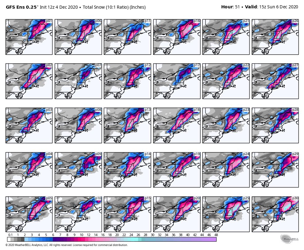
GFS and Euro trying to paint 12"+ of snow in Worcester MA with 925's around 32, 850's around 31 and surface not dropping below 35 F. Man I see the dynamics in play but it's going to have snow > 3" per hour for many hours to obtain that kind of accumulation. I'd take the under on those accumulations in SNE less the very highest elevations above 1500' feet. Of course higher elevations of ME and NH will cash in and I believe the accumulations there.
I think BOX may get skunked < 2" on this one in terms of accumulations. There's only so hard it can snow to offset the airmass.
BTW, you'd need a yard stick to measure the snow if there was a cold air mass up there.
I just don't think so...

heehaw453- Advanced Forecaster
- Posts : 3906
Reputation : 86
Join date : 2014-01-20
Location : Bedminster Township, PA Elevation 600' ASL
Page 3 of 11 • 1, 2, 3, 4 ... 9, 10, 11 ![]()
|
|
|