
 Search
12/16-12/17 Godzilla: Final Snow Map & Obsevations
Page 5 of 32 •  1, 2, 3, 4, 5, 6 ... 18 ... 32
 ![]()
Re: 12/16-12/17 Godzilla: Final Snow Map & Obsevations
![]() by heehaw453 Wed Dec 16, 2020 10:39 am
by heehaw453 Wed Dec 16, 2020 10:39 am
aiannone wrote:Upton raised amounts for Western sections of Suffolk County, LI
URGENT - WINTER WEATHER MESSAGE
National Weather Service New York NY
851 AM EST Wed Dec 16 2020
NJZ006-NYZ072>075-078-080-176>179-162300-
/O.CON.KOKX.WS.W.0001.201216T1900Z-201217T1800Z/
Hudson-New York (Manhattan)-Bronx-Richmond (Staten Island)-
Kings (Brooklyn)-Northwestern Suffolk-Southwestern Suffolk-
Northern Queens-Northern Nassau-Southern Queens-Southern Nassau-
851 AM EST Wed Dec 16 2020
...WINTER STORM WARNING REMAINS IN EFFECT FROM 2 PM THIS
AFTERNOON TO 1 PM EST THURSDAY...
* WHAT...Heavy snow expected. Total snow accumulations of 8 to 14
inches. Winds gusting as high as 45 mph.
* WHERE...Portions of northeast New Jersey and southeast New
York.
* WHEN...From 2 PM this afternoon to 1 PM EST Thursday.
* IMPACTS...Travel could be very difficult to impossible. The
hazardous conditions could impact the morning or evening
commute.
* ADDITIONAL DETAILS...Snowfall amounts could be a bit lower than
forecast along south coastal portions of the region if sleet
mixes in tonight.
If you don't mix it'll be blizzard conditions for sure! The winds are going to be very gusty.
heehaw453- Advanced Forecaster

- Posts : 3906
Join date : 2014-01-20
Re: 12/16-12/17 Godzilla: Final Snow Map & Obsevations
![]() by sroc4 Wed Dec 16, 2020 10:39 am
by sroc4 Wed Dec 16, 2020 10:39 am
jmanley32 wrote:Of course leave us with bad news thanks lol, have a great day!!rb924119 wrote:
This is my last post for a while, as I’ll be heading to work, but will follow along as best I can.

Dont worry Jon. In Every storm some places bust low, and some bust high. EVERY storm. CAD isnt touching those areas or weakly at best. The Mid Atlantic and NE is where its strongest. Rays bias towards his original idea are leaking out with every comment today. LOL As is mine in the opposite direction. If the immediate coast over performs there is legitimate reasoning as to why(see all my prev discussions. If it under performs then there is legitimate reasons as to why (see Rays prev discussions). Ive highlighted some of said discussions from both of us from back on the morning of Dec 11th. Im pretty confident both of us will have parts of our discussions verify and parts of it go awry.
ME:
"In addition the first system seem to create a kind of pseudo 50/50 low. Combined with the PNA region out west its "just enough" to force the track no further west than a coastal hugger worst case scenario IMHO.....Regarding the PNA ridge GFS trend forecast(euro is modeled very similar in its timing and strength as well currently) has the 500mb forecast trending stronger In the NW CONUS right as our surface LP is coming off the EC. If true the timing of the ridging is such that combined with the HP parked to the N, a pseudo 50/50 LP and the ridge going up instead of on its way down you get a trajectory NE and a track to the SE of LI somehwhere towards the BM. NW of or SE of yet to be determined. However if the timing of the ridge out west isnt modeled correctly then the track of the LP may flatten out and hence the more ENE track and miss to our SE.....still a LOOOONNGGG way to go with this one, but getting the HP set up to the N is step one to the equation which is looking more and more likely. Flooding the area with warm is is becoming less and less likely. Dont get me wrong the coastal plain may still rain or mix if LP track is tucked in, but overall this set up is leaps and bounds better than the last. "
RAY:
Just looking at these annotations and disregarding the rest of the hemisphere for a moment, you can see that our surface high pressure that initially starts to our northeast becomes contaminated with maritime polar air, thanks to Monday's energy allowing a secondary area of high pressure to slip off the East Coast ahead of the storm of interest. When you consider isallobaric and density components, this will begin imparting an effectual easterly "component" to the low-level and thermal flow, thereby moderating any true arctic component from the northern stream high. Secondly, because of the weakness that is created in response to the phasing of the displaced 50/50 low and Monday's energy beneath blocking that is a bit too far poleward, the phasing energies are forced to slip eastward beneath the block. As they do, they take our surface highs with them, and therefore, the proximity to our lone truly arctic low-level dome decreases as it shifts northeastward behind the departing phasing troughs. Then, as return flow increases in their wake, ridging begins to build behind them (red arrow).
Now, when you consider the rest of the hemispheric and tropical factors, such as the lack of a 70/70 ridge, a truly negative EPO/WPO(for this quick and dirty rebuttal I will consider them as neutral), a truly positive, and well oriented PNA (again, considering this as neutral), and unfavorable tropical forcings combined with anomalously warm Atlantic and Caribbean waters, to me we should see this overall pattern retract toward the pole a bit, thereby allowing everything to shift north (favorable confluence/low-level cold dome, 50/50 low, Atlantic ridge). As a result, then, it would stand to reason that a less favorable storm track and/or airmass becomes more likely than it appears right now in the modeling.
Last edited by sroc4 on Wed Dec 16, 2020 10:41 am; edited 1 time in total
sroc4- Admin

- Posts : 8354
Join date : 2013-01-07
rb924119 likes this post
Re: 12/16-12/17 Godzilla: Final Snow Map & Obsevations
![]() by heehaw453 Wed Dec 16, 2020 10:40 am
by heehaw453 Wed Dec 16, 2020 10:40 am
mikeypizano wrote:...WINTER STORM WARNING REMAINS IN EFFECT UNTIL 10 AM EST
THURSDAY...
* WHAT...Heavy snow expected. Total snow accumulations of 18 to
24 inches.
* WHERE...Southern Wayne, Pike, Lackawanna, Luzerne and Wyoming
counties.
* WHEN...Until 10 AM EST Thursday.
* IMPACTS...Travel could be very difficult to impossible. The
hazardous conditions will likely impact the evening and
Thursday morning commutes.
* ADDITIONAL DETAILS...Snowfall rates of 2 to 3 inches per hour
are possible late this afternoon and through the overnight.
East to northeast winds at 10 to 20 mph with gusts to 30 mph,
especially at higher elevations, may cause some blowing snow and
isolated power outages.
PRECAUTIONARY/PREPAREDNESS ACTIONS...
If you must travel, keep an extra flashlight, food, and water in
your vehicle in case of an emergency.
The latest road conditions for the state you are calling from can
be obtained by calling 5 1 1.
The Pennsylvania Department of Transportation and Pennsylvania
Turnpike Commission strongly encourage motorist to heed all
travel restrictions and delay unnecessary travel. Visit
www.511pa.com for the latest travel, roadways, and traffic
conditions.
&&
Looks like I will be getting hammered!
WOW!!!
heehaw453- Advanced Forecaster
- Posts : 3906
Reputation : 86
Join date : 2014-01-20
Location : Bedminster Township, PA Elevation 600' ASL
Re: 12/16-12/17 Godzilla: Final Snow Map & Obsevations
![]() by amugs Wed Dec 16, 2020 10:41 am
by amugs Wed Dec 16, 2020 10:41 am

_________________
Mugs
AKA:King: Snow Weenie
Self Proclaimed
WINTER 2014-15 : 55.12" +.02 for 6 coatings (avg. 35")
WINTER 2015-16 Total - 29.8" (Avg 35")
WINTER 2016-17 : 39.5" so far

amugs- Advanced Forecaster - Mod

- Posts : 15095
Reputation : 213
Join date : 2013-01-07
Age : 54
Location : Hillsdale,NJ
Sparky Sparticles likes this post
Re: 12/16-12/17 Godzilla: Final Snow Map & Obsevations
![]() by SoulSingMG Wed Dec 16, 2020 10:44 am
by SoulSingMG Wed Dec 16, 2020 10:44 am
12z


SoulSingMG- Senior Enthusiast

- Posts : 2853
Reputation : 74
Join date : 2013-12-11
Location : Long Island City, NY
Re: 12/16-12/17 Godzilla: Final Snow Map & Obsevations
![]() by heehaw453 Wed Dec 16, 2020 10:48 am
by heehaw453 Wed Dec 16, 2020 10:48 am
heehaw453- Advanced Forecaster
- Posts : 3906
Reputation : 86
Join date : 2014-01-20
Location : Bedminster Township, PA Elevation 600' ASL
Re: 12/16-12/17 Godzilla: Final Snow Map & Obsevations
![]() by dsix85 Wed Dec 16, 2020 10:49 am
by dsix85 Wed Dec 16, 2020 10:49 am
dsix85- Pro Enthusiast

- Posts : 349
Reputation : 8
Join date : 2014-01-01
Location : New York
Re: 12/16-12/17 Godzilla: Final Snow Map & Obsevations
![]() by essexcountypete Wed Dec 16, 2020 10:49 am
by essexcountypete Wed Dec 16, 2020 10:49 am
SoulSingMG wrote:I still hate the GFS inherently, but this is another step in the right direction for our relationship.
12z
Your true friends will warn you not to fall back into bad relationships. The GFS will always betray you.

essexcountypete- Pro Enthusiast
- Posts : 783
Reputation : 12
Join date : 2013-12-09
Location : Bloomfield, NJ
SoulSingMG likes this post
Re: 12/16-12/17 Godzilla: Final Snow Map & Obsevations
![]() by sroc4 Wed Dec 16, 2020 10:50 am
by sroc4 Wed Dec 16, 2020 10:50 am
This means less warm nosing into the coast plain on the GFS
While I didnt post the map below the 850 low passes south of LI which keeps that level below freezing for all. Its a subtle detail but little wobbles to these mid level features will mean ALLLLL the difference.


_________________
"In weather and in life, there's no winning and losing; there's only winning and learning."
WINTER 2012/2013 TOTALS 43.65"WINTER 2017/2018 TOTALS 62.85" WINTER 2022/2023 TOTALS 4.9"
WINTER 2013/2014 TOTALS 64.85"WINTER 2018/2019 TOTALS 14.25" WINTER 2023/2024 TOTALS 13.1"
WINTER 2014/2015 TOTALS 71.20"WINTER 2019/2020 TOTALS 6.35"
WINTER 2015/2016 TOTALS 35.00"WINTER 2020/2021 TOTALS 37.75"
WINTER 2016/2017 TOTALS 42.25"WINTER 2021/2022 TOTALS 31.65"

sroc4- Admin
- Posts : 8354
Reputation : 302
Join date : 2013-01-07
Location : Wading River, LI
rb924119 and SoulSingMG like this post
Re: 12/16-12/17 Godzilla: Final Snow Map & Obsevations
![]() by Frank_Wx Wed Dec 16, 2020 10:52 am
by Frank_Wx Wed Dec 16, 2020 10:52 am
dsix85 wrote:Frank-anticipated start & end time still holding firm to your prediction?
Yes!
_________________
_______________________________________________________________________________________________________
CLICK HERE to view NJ Strong Snowstorm Classifications

Frank_Wx- Godzilla Seeker
- Posts : 21305
Reputation : 328
Join date : 2013-01-05
Age : 32
Location : Jersey City, NJ -

Re: 12/16-12/17 Godzilla: Final Snow Map & Obsevations
![]() by amugs Wed Dec 16, 2020 10:53 am
by amugs Wed Dec 16, 2020 10:53 am
rb924119 wrote:
This is my last post for a while, as I’ll be heading to work, but will follow along as best I can.
He's a warmicists and its about he track they dont have CAD we will have for God's sake its 200 plus miles from us - though there will be a warm tongue push but the air is very cold dense air and its being pumped down by a 1040 HP that has been jacked up by 939 LP over Newfoundland - lets not forget that!
Snowing moderately by my son at Penn State in State College - earlier than expected!!
_________________
Mugs
AKA:King: Snow Weenie
Self Proclaimed
WINTER 2014-15 : 55.12" +.02 for 6 coatings (avg. 35")
WINTER 2015-16 Total - 29.8" (Avg 35")
WINTER 2016-17 : 39.5" so far
amugs- Advanced Forecaster - Mod
- Posts : 15095
Reputation : 213
Join date : 2013-01-07
Age : 54
Location : Hillsdale,NJ
Re: 12/16-12/17 Godzilla: Final Snow Map & Obsevations
![]() by Frank_Wx Wed Dec 16, 2020 10:53 am
by Frank_Wx Wed Dec 16, 2020 10:53 am
sroc4 wrote:Here are the majoir differences in why the GFS and the NAM are different. At 700mb you can clearly see the orientation on the NAM is SW to NE and further N overall. GFS on the other hand is oreinted more W to E and is further S.
This means less warm nosing into the coast plain on the GFS
While I didnt post the map below the 850 low passes south of LI which keeps that level below freezing for all. Its a subtle detail but little wobbles to these mid level features will mean ALLLLL the difference.
True, but I still hate the H7 vort being right over us. Someone is going to pay for that.

_________________
_______________________________________________________________________________________________________
CLICK HERE to view NJ Strong Snowstorm Classifications
Frank_Wx- Godzilla Seeker
- Posts : 21305
Reputation : 328
Join date : 2013-01-05
Age : 32
Location : Jersey City, NJ -
rb924119 likes this post
Re: 12/16-12/17 Godzilla: Final Snow Map & Obsevations
![]() by bloc1357 Wed Dec 16, 2020 10:56 am
by bloc1357 Wed Dec 16, 2020 10:56 am
bloc1357- Pro Enthusiast
- Posts : 344
Reputation : 10
Join date : 2013-03-05
Age : 47
Location : West Babylon, NY - 11704
Re: 12/16-12/17 Godzilla: Final Snow Map & Obsevations
![]() by Frank_Wx Wed Dec 16, 2020 10:57 am
by Frank_Wx Wed Dec 16, 2020 10:57 am
Current temps:
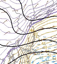
Current wet bulb temps. Based off these two images, you can kind of tell where the R/S line might be.
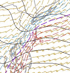
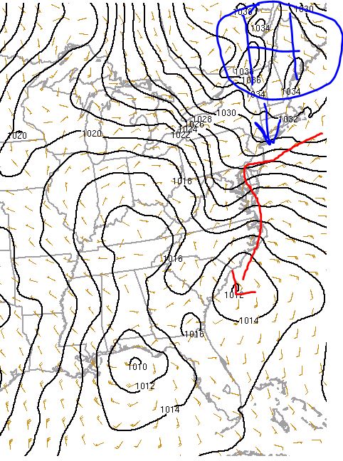
Current surface depiction. Our storm is getting going off the coast of NC. The red line is the latest GFS track. This is what you want to track all day long. Does the low follow the due north-northwest path, or does it stay more north-northeast.
_________________
_______________________________________________________________________________________________________
CLICK HERE to view NJ Strong Snowstorm Classifications
Frank_Wx- Godzilla Seeker
- Posts : 21305
Reputation : 328
Join date : 2013-01-05
Age : 32
Location : Jersey City, NJ -
rb924119 and SoulSingMG like this post
Re: 12/16-12/17 Godzilla: Final Snow Map & Obsevations
![]() by hyde345 Wed Dec 16, 2020 11:04 am
by hyde345 Wed Dec 16, 2020 11:04 am
mikeypizano wrote:...WINTER STORM WARNING REMAINS IN EFFECT UNTIL 10 AM EST
THURSDAY...
* WHAT...Heavy snow expected. Total snow accumulations of 18 to
24 inches.
* WHERE...Southern Wayne, Pike, Lackawanna, Luzerne and Wyoming
counties.
* WHEN...Until 10 AM EST Thursday.
* IMPACTS...Travel could be very difficult to impossible. The
hazardous conditions will likely impact the evening and
Thursday morning commutes.
* ADDITIONAL DETAILS...Snowfall rates of 2 to 3 inches per hour
are possible late this afternoon and through the overnight.
East to northeast winds at 10 to 20 mph with gusts to 30 mph,
especially at higher elevations, may cause some blowing snow and
isolated power outages.
PRECAUTIONARY/PREPAREDNESS ACTIONS...
If you must travel, keep an extra flashlight, food, and water in
your vehicle in case of an emergency.
The latest road conditions for the state you are calling from can
be obtained by calling 5 1 1.
The Pennsylvania Department of Transportation and Pennsylvania
Turnpike Commission strongly encourage motorist to heed all
travel restrictions and delay unnecessary travel. Visit
www.511pa.com for the latest travel, roadways, and traffic
conditions.
&&
Looks like I will be getting hammered!
You snowplow right? If so you better get some rest because you are going to be busy.

hyde345- Pro Enthusiast
- Posts : 1082
Reputation : 48
Join date : 2013-01-08
Location : Hyde Park, NY
Re: 12/16-12/17 Godzilla: Final Snow Map & Obsevations
![]() by billg315 Wed Dec 16, 2020 11:05 am
by billg315 Wed Dec 16, 2020 11:05 am

billg315- Advanced Forecaster - Mod
- Posts : 4483
Reputation : 185
Join date : 2015-01-24
Age : 50
Location : Flemington, NJ
Re: 12/16-12/17 Godzilla: Final Snow Map & Obsevations
![]() by heehaw453 Wed Dec 16, 2020 11:06 am
by heehaw453 Wed Dec 16, 2020 11:06 am
Winds are already moving the trees just a bit...
heehaw453- Advanced Forecaster
- Posts : 3906
Reputation : 86
Join date : 2014-01-20
Location : Bedminster Township, PA Elevation 600' ASL
Re: 12/16-12/17 Godzilla: Final Snow Map & Obsevations
![]() by billg315 Wed Dec 16, 2020 11:07 am
by billg315 Wed Dec 16, 2020 11:07 am

billg315- Advanced Forecaster - Mod
- Posts : 4483
Reputation : 185
Join date : 2015-01-24
Age : 50
Location : Flemington, NJ
Re: 12/16-12/17 Godzilla: Final Snow Map & Obsevations
![]() by Scullybutcher Wed Dec 16, 2020 11:07 am
by Scullybutcher Wed Dec 16, 2020 11:07 am

Scullybutcher- Pro Enthusiast
- Posts : 543
Reputation : 16
Join date : 2013-02-06
Location : North Smithtown, western Suffolk county, long island
Re: 12/16-12/17 Godzilla: Final Snow Map & Obsevations
![]() by weatherwatchermom Wed Dec 16, 2020 11:07 am
by weatherwatchermom Wed Dec 16, 2020 11:07 am
Frank_Wx wrote:Today is going to be an epic battle between warm vs cold air. Tracking it will be lots of fun.
Current temps:
Current wet bulb temps. Based off these two images, you can kind of tell where the R/S line might be.
Current surface depiction. Our storm is getting going off the coast of NC. The red line is the latest GFS track. This is what you want to track all day long. Does the low follow the due north-northwest path, or does it stay more north-northeast.
Good Morning,
I did not follow along yesterday(had a migrane and threw a tantrum..when I saw things going down hill..) back to my self today!! so I have a question on the first map..the cold line is the purple line. I am a tiny bit above the battle zone area..so I want to understand as I follow along. Currently at 31* with the real feel of 26 feel and smells like snow!! what ever we get we get..TIA winds are steady at 10 funny some coming out of north east other out of south east..is that part of the battle????
Last edited by weatherwatchermom on Wed Dec 16, 2020 11:11 am; edited 1 time in total

weatherwatchermom- Senior Enthusiast
- Posts : 3793
Reputation : 78
Join date : 2014-11-25
Location : Hazlet Township, NJ
Re: 12/16-12/17 Godzilla: Final Snow Map & Obsevations
![]() by sroc4 Wed Dec 16, 2020 11:10 am
by sroc4 Wed Dec 16, 2020 11:10 am
_________________
"In weather and in life, there's no winning and losing; there's only winning and learning."
WINTER 2012/2013 TOTALS 43.65"WINTER 2017/2018 TOTALS 62.85" WINTER 2022/2023 TOTALS 4.9"
WINTER 2013/2014 TOTALS 64.85"WINTER 2018/2019 TOTALS 14.25" WINTER 2023/2024 TOTALS 13.1"
WINTER 2014/2015 TOTALS 71.20"WINTER 2019/2020 TOTALS 6.35"
WINTER 2015/2016 TOTALS 35.00"WINTER 2020/2021 TOTALS 37.75"
WINTER 2016/2017 TOTALS 42.25"WINTER 2021/2022 TOTALS 31.65"
sroc4- Admin
- Posts : 8354
Reputation : 302
Join date : 2013-01-07
Location : Wading River, LI
amugs likes this post
Re: 12/16-12/17 Godzilla: Final Snow Map & Obsevations
![]() by amugs Wed Dec 16, 2020 11:12 am
by amugs Wed Dec 16, 2020 11:12 am
_________________
Mugs
AKA:King: Snow Weenie
Self Proclaimed
WINTER 2014-15 : 55.12" +.02 for 6 coatings (avg. 35")
WINTER 2015-16 Total - 29.8" (Avg 35")
WINTER 2016-17 : 39.5" so far
amugs- Advanced Forecaster - Mod
- Posts : 15095
Reputation : 213
Join date : 2013-01-07
Age : 54
Location : Hillsdale,NJ
Re: 12/16-12/17 Godzilla: Final Snow Map & Obsevations
![]() by Frank_Wx Wed Dec 16, 2020 11:16 am
by Frank_Wx Wed Dec 16, 2020 11:16 am
billg315 wrote:Current radar situation:
Some of that might be virga
Also, does anyone know what is wrong with this radar? It is my favorite one, but when I post it in the forum, it shows a completely different time stamp
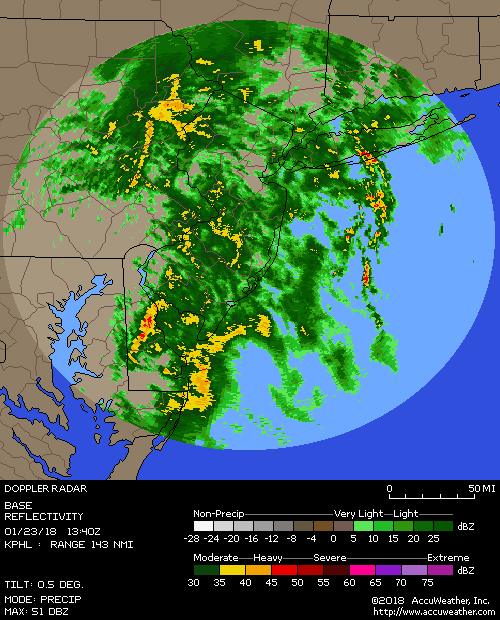
But if you click the link, it should be correct.
http://sirocco.accuweather.com/nxssa_r1_h_500x620d/r1h/inxr1Kphla_h.gif
_________________
_______________________________________________________________________________________________________
CLICK HERE to view NJ Strong Snowstorm Classifications
Frank_Wx- Godzilla Seeker
- Posts : 21305
Reputation : 328
Join date : 2013-01-05
Age : 32
Location : Jersey City, NJ -
Re: 12/16-12/17 Godzilla: Final Snow Map & Obsevations
![]() by aiannone Wed Dec 16, 2020 11:16 am
by aiannone Wed Dec 16, 2020 11:16 am
_________________
-Alex Iannone-

aiannone- Senior Enthusiast - Mod
- Posts : 4815
Reputation : 92
Join date : 2013-01-07
Location : Saint James, LI (Northwest Suffolk Co.)
Re: 12/16-12/17 Godzilla: Final Snow Map & Obsevations
![]() by Frank_Wx Wed Dec 16, 2020 11:18 am
by Frank_Wx Wed Dec 16, 2020 11:18 am
weatherwatchermom wrote:Frank_Wx wrote:Today is going to be an epic battle between warm vs cold air. Tracking it will be lots of fun.
Current temps:
Current wet bulb temps. Based off these two images, you can kind of tell where the R/S line might be.
Current surface depiction. Our storm is getting going off the coast of NC. The red line is the latest GFS track. This is what you want to track all day long. Does the low follow the due north-northwest path, or does it stay more north-northeast.
Good Morning,
I did not follow along yesterday(had a migrane and threw a tantrum..when I saw things going down hill..) back to my self today!! so I have a question on the first map..the cold line is the purple line. I am a tiny bit above the battle zone area..so I want to understand as I follow along. Currently at 31* with the real feel of 26 feel and smells like snow!! what ever we get we get..TIA winds are steady at 10 funny some coming out of north east other out of south east..is that part of the battle????
Yes it is! Your wet bulb temps looks lower than your current temp, and that will be key to watch as well. Especially see how it looks say 2 hours from now.
_________________
_______________________________________________________________________________________________________
CLICK HERE to view NJ Strong Snowstorm Classifications
Frank_Wx- Godzilla Seeker
- Posts : 21305
Reputation : 328
Join date : 2013-01-05
Age : 32
Location : Jersey City, NJ -
Re: 12/16-12/17 Godzilla: Final Snow Map & Obsevations
![]() by aiannone Wed Dec 16, 2020 11:19 am
by aiannone Wed Dec 16, 2020 11:19 am
Frank_Wx wrote:Today is going to be an epic battle between warm vs cold air. Tracking it will be lots of fun.
Current temps:
Current wet bulb temps. Based off these two images, you can kind of tell where the R/S line might be.
Current surface depiction. Our storm is getting going off the coast of NC. The red line is the latest GFS track. This is what you want to track all day long. Does the low follow the due north-northwest path, or does it stay more north-northeast.
FWIW, the r/s line based off those images are exactly where the latest RPM has the r/s. Just south of LI. Budges into the south shore for an hour or so and then back to snow well offshore.
_________________
-Alex Iannone-
aiannone- Senior Enthusiast - Mod
- Posts : 4815
Reputation : 92
Join date : 2013-01-07
Location : Saint James, LI (Northwest Suffolk Co.)
Re: 12/16-12/17 Godzilla: Final Snow Map & Obsevations
![]() by aiannone Wed Dec 16, 2020 11:20 am
by aiannone Wed Dec 16, 2020 11:20 am
'Forecast is generally on track. Temperature are a bit cooler
than previously forecasted, so lowered hourly and max
temperatures today. Also, winds are higher, so increased wind
speeds through the morning. This may be due to slightly higher
pressure in southeastern Canada than the models were showing
previously."
_________________
-Alex Iannone-
aiannone- Senior Enthusiast - Mod
- Posts : 4815
Reputation : 92
Join date : 2013-01-07
Location : Saint James, LI (Northwest Suffolk Co.)
bloc1357 and SoulSingMG like this post
Page 5 of 32 • 1, 2, 3, 4, 5, 6 ... 18 ... 32 ![]()