February 1st-2nd Godzilla, Part III: 1st Call Snow Map
+50
Zhukov1945
CDF24
SkiSeadooJoe
gambri
algae888
essexcountypete
skinsfan1177
MattyICE
phil155
Scullybutcher
Mathgod55
sroc4
lja
Taffy
docstox12
moleson
adamfitz1969
CnWestMilford76
Fededle22
SNOW MAN
Artechmetals
sabamfa
Irish
amugs
DAYBLAZER
Joe Snow
WeatherBob
dsix85
hurrysundown23
aiannone
nutleyblizzard
dkodgis
SENJsnowman
TheAresian
CPcantmeasuresnow
GreyBeard
Snownyc
rb924119
larryrock72
lglickman1
bobjohnsonforthehall
heehaw453
mwilli
mmanisca
Grselig
frank 638
jmanley32
billg315
weatherwatchermom
Frank_Wx
54 posters
Page 4 of 24
Page 4 of 24 •  1, 2, 3, 4, 5 ... 14 ... 24
aiannone- Senior Enthusiast - Mod

- Posts : 4815
Join date : 2013-01-07
 Re: February 1st-2nd Godzilla, Part III: 1st Call Snow Map
billg315 wrote:The 0z NAM, which is not a big change from the 18z NAM is kind of why my snow map looks the way it does. It likes the warm air intrusion across south and coastal NJ, and doesn't like the heavy snow getting back too far west. Could be out to lunch, but that 18z run spooked me on going stronger with big totals outside the jackpot and NW, and this does as well.
It stayed in line with 18z. I like the thermal profiles over Long Island on it! Lol back in December it was warming the 850 over Suffolk and sure enough we went over to sleet in my area. Hopefully it’s hanging in there below freezing works out!

mmanisca- Pro Enthusiast

- Posts : 299
Reputation : 3
Join date : 2013-01-23
Age : 65
Location : Deer Park, Long Island
 Re: February 1st-2nd Godzilla, Part III: 1st Call Snow Map
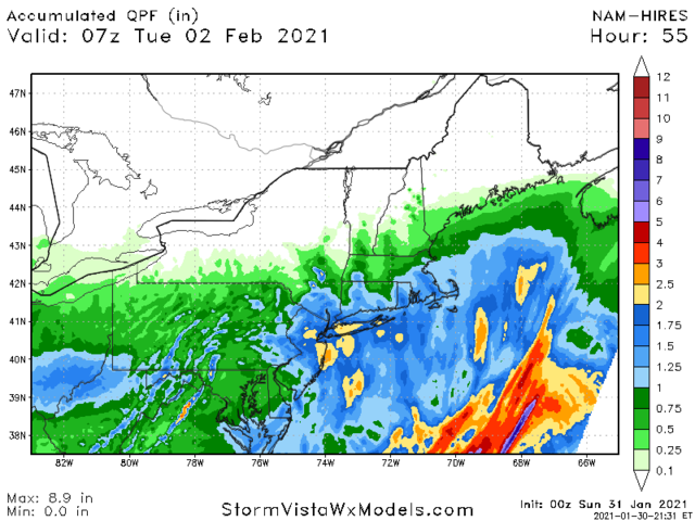
Hi-Res NAM


_________________
_______________________________________________________________________________________________________
CLICK HERE to view NJ Strong Snowstorm Classifications
 Re: February 1st-2nd Godzilla, Part III: 1st Call Snow Map
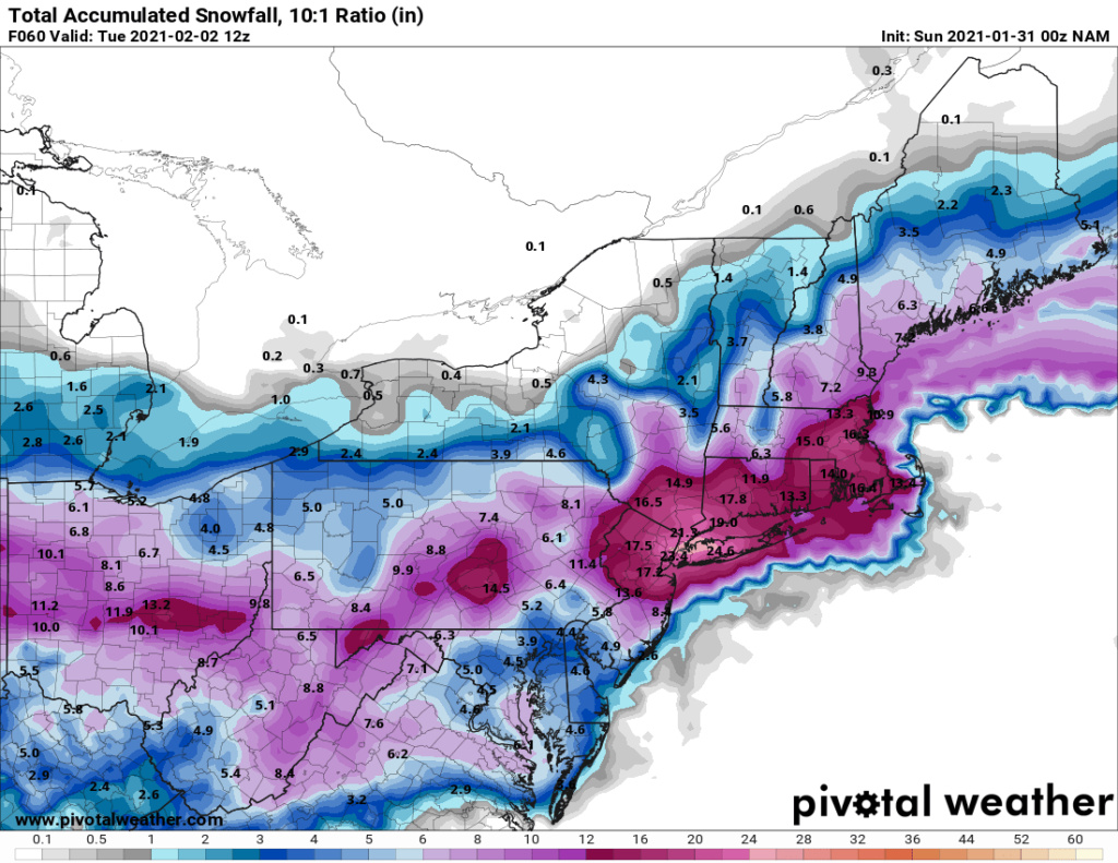
10am tuesday it is still snowing on the nam


_________________
_______________________________________________________________________________________________________
CLICK HERE to view NJ Strong Snowstorm Classifications
 Re: February 1st-2nd Godzilla, Part III: 1st Call Snow Map
Roidzilla


_________________
_______________________________________________________________________________________________________
CLICK HERE to view NJ Strong Snowstorm Classifications
 Interesting
For Sayreville, NJ per TWC inane snow totals
https://weather.com/weather/tenday/l/22b0540f93d84a08aee6e6e55d24a7a031254bd2138e5aacaa34d8807d2c621f
https://weather.com/weather/tenday/l/22b0540f93d84a08aee6e6e55d24a7a031254bd2138e5aacaa34d8807d2c621f
hurrysundown23- Posts : 53
Reputation : 1
Join date : 2017-01-04
Location : Sayreville, NJ
 Re: February 1st-2nd Godzilla, Part III: 1st Call Snow Map
Hi-Res


_________________
_______________________________________________________________________________________________________
CLICK HERE to view NJ Strong Snowstorm Classifications
 Re: February 1st-2nd Godzilla, Part III: 1st Call Snow Map
Wow SRoc we cashed in the goods here in Suffolk!
dsix85- Pro Enthusiast

- Posts : 349
Reputation : 8
Join date : 2014-01-01
Location : New York
sroc4 and oldtimer like this post
 Re: February 1st-2nd Godzilla, Part III: 1st Call Snow Map
These are the top analogs that closely resemble the pattern and set-up to our looming storm. Blizzard of 96' is number one.
http://www.eas.slu.edu/CIPS/ANALOG/DFHR.php?reg=EC&fhr=F060&rundt=2021013012&map=tbl
Unfortunately I was only 4 years old. Would love to live through something like that.....
http://www.eas.slu.edu/CIPS/ANALOG/DFHR.php?reg=EC&fhr=F060&rundt=2021013012&map=tbl
Unfortunately I was only 4 years old. Would love to live through something like that.....
_________________
_______________________________________________________________________________________________________
CLICK HERE to view NJ Strong Snowstorm Classifications
Grselig likes this post
 Re: February 1st-2nd Godzilla, Part III: 1st Call Snow Map
yeah! Certainly looks good but let’s see if it’s the trend!dsix85 wrote:Wow SRoc we cashed in the goods here in Suffolk!

mmanisca- Pro Enthusiast

- Posts : 299
Reputation : 3
Join date : 2013-01-23
Age : 65
Location : Deer Park, Long Island
 Re: February 1st-2nd Godzilla, Part III: 1st Call Snow Map
Frank- did the coast trend colder on this run?
dsix85- Pro Enthusiast

- Posts : 349
Reputation : 8
Join date : 2014-01-01
Location : New York
 Re: February 1st-2nd Godzilla, Part III: 1st Call Snow Map
dsix85 wrote:Frank- did the coast trend colder on this run?
No real trend. Same as prior run. EURO is the warmest model but also shows the best snow/dynamics (among the globals).
This is the warmest frame of the GFS. NAM is similiar.

_________________
_______________________________________________________________________________________________________
CLICK HERE to view NJ Strong Snowstorm Classifications
 Re: February 1st-2nd Godzilla, Part III: 1st Call Snow Map
I vividly remember the 1996 storm. Surface low moving along a stationary elongated SW to NE trough. A coastal front formed and the Surface low moved NE along a coastal front and gave us 12 in of snow. Then the potent 500 MB low cruised off the SE Jersey coast about 6 to 8 hrs later moving NE. That gave us another 12 inches in a 4 to 6 hr period.

WeatherBob- Meteorologist

- Posts : 683
Reputation : 83
Join date : 2013-12-13
Location : Caldwell, NJ - NW Essex County - Altitude 500 FT
CnWestMilford76 likes this post
 Re: February 1st-2nd Godzilla, Part III: 1st Call Snow Map
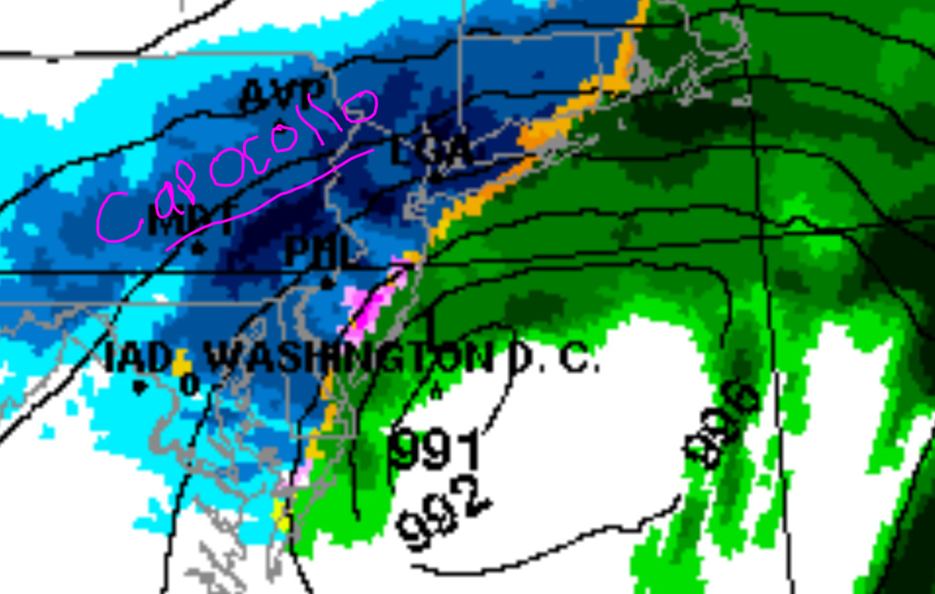
00z RGEM


_________________
_______________________________________________________________________________________________________
CLICK HERE to view NJ Strong Snowstorm Classifications
 Re: February 1st-2nd Godzilla, Part III: 1st Call Snow Map

RGEM bring home the capocollo
_________________
_______________________________________________________________________________________________________
CLICK HERE to view NJ Strong Snowstorm Classifications
 Re: February 1st-2nd Godzilla, Part III: 1st Call Snow Map
_________________
_______________________________________________________________________________________________________
CLICK HERE to view NJ Strong Snowstorm Classifications
 Re: February 1st-2nd Godzilla, Part III: 1st Call Snow Map
Just want to say goodbye to all of my members who live on Long Island. This death band on the NAM bring you 5 inches/hour and I'm not sure you will survive it. Its been a blast!


_________________
_______________________________________________________________________________________________________
CLICK HERE to view NJ Strong Snowstorm Classifications
oldtimer, dolphins222, brownie and billg315 like this post
 Re: February 1st-2nd Godzilla, Part III: 1st Call Snow Map
Is it game on with the Rgem Frank? I thought you tossed the last run of it?

WeatherBob- Meteorologist

- Posts : 683
Reputation : 83
Join date : 2013-12-13
Location : Caldwell, NJ - NW Essex County - Altitude 500 FT
 Re: February 1st-2nd Godzilla, Part III: 1st Call Snow Map
The slow nature of the evolution of this storm, existing arctic air and maturation process below our latitude gives more credence to these insane amounts of snow. Stalls are the way these things can happen. But it just all has to be right.
heehaw453- Advanced Forecaster

- Posts : 3906
Reputation : 86
Join date : 2014-01-20
Location : Bedminster Township, PA Elevation 600' ASL
 Re: February 1st-2nd Godzilla, Part III: 1st Call Snow Map
Frank_Wx wrote:Just want to say goodbye to all of my members who live on Long Island. This death band on the NAM bring you 5 inches/hour and I'm not sure you will survive it. Its been a blast!
_________________
_______________________________________________________________________________________________________
CLICK HERE to view NJ Strong Snowstorm Classifications
 Re: February 1st-2nd Godzilla, Part III: 1st Call Snow Map
5 inches/hour your right Frank its over n out. hempstead,Hoestra u. Uniondale buried
mwilli- Posts : 132
Reputation : 3
Join date : 2019-02-11
 Re: February 1st-2nd Godzilla, Part III: 1st Call Snow Map
The RGEM has literally lost its mind.
.png.0e20a45d81650696e7f459e94a246f84.png)
.png.0e20a45d81650696e7f459e94a246f84.png)
_________________
_______________________________________________________________________________________________________
CLICK HERE to view NJ Strong Snowstorm Classifications
 Re: February 1st-2nd Godzilla, Part III: 1st Call Snow Map
Four feet of snow in the Lehigh Valley. Nothing unusual about that. LOL.Frank_Wx wrote:The RGEM has literally lost its mind.

billg315- Advanced Forecaster - Mod

- Posts : 4483
Reputation : 185
Join date : 2015-01-24
Age : 50
Location : Flemington, NJ
 Re: February 1st-2nd Godzilla, Part III: 1st Call Snow Map
How does PA get 40+ and Long Island barely a foot?
dsix85- Pro Enthusiast

- Posts : 349
Reputation : 8
Join date : 2014-01-01
Location : New York
 Re: February 1st-2nd Godzilla, Part III: 1st Call Snow Map
I think in the end the answer is: it does not. loldsix85 wrote:How does PA get 40+ and Long Island barely a foot?

billg315- Advanced Forecaster - Mod

- Posts : 4483
Reputation : 185
Join date : 2015-01-24
Age : 50
Location : Flemington, NJ
brownie and heehaw453 like this post
 Re: February 1st-2nd Godzilla, Part III: 1st Call Snow Map
billg315 wrote:The 0z NAM, which is not a big change from the 18z NAM is kind of why my snow map looks the way it does. It likes the warm air intrusion across south and coastal NJ, and doesn't like the heavy snow getting back too far west. Could be out to lunch, but that 18z run spooked me on going stronger with big totals outside the jackpot and NW, and this does as well.
It stayed in line with 18z. I like the thermal profiles over Long Island on it! Lol back in December it was warming the 850 over Suffolk and sure enough we went over to sleet in my area. Hopefully it’s hanging in there below freezing works out!

mmanisca- Pro Enthusiast

- Posts : 299
Reputation : 3
Join date : 2013-01-23
Age : 65
Location : Deer Park, Long Island
Page 4 of 24 •  1, 2, 3, 4, 5 ... 14 ... 24
Page 4 of 24
Permissions in this forum:
You cannot reply to topics in this forum
 Home
Home


