
 Search
February 1st-2nd Roidzilla, Part IV: Final Forecast
Page 1 of 29 • 1, 2, 3 ... 15 ... 29 ![]()

February 1st-2nd Roidzilla, Part IV: Final Forecast
![]() by Frank_Wx Sun Jan 31, 2021 2:09 pm
by Frank_Wx Sun Jan 31, 2021 2:09 pm
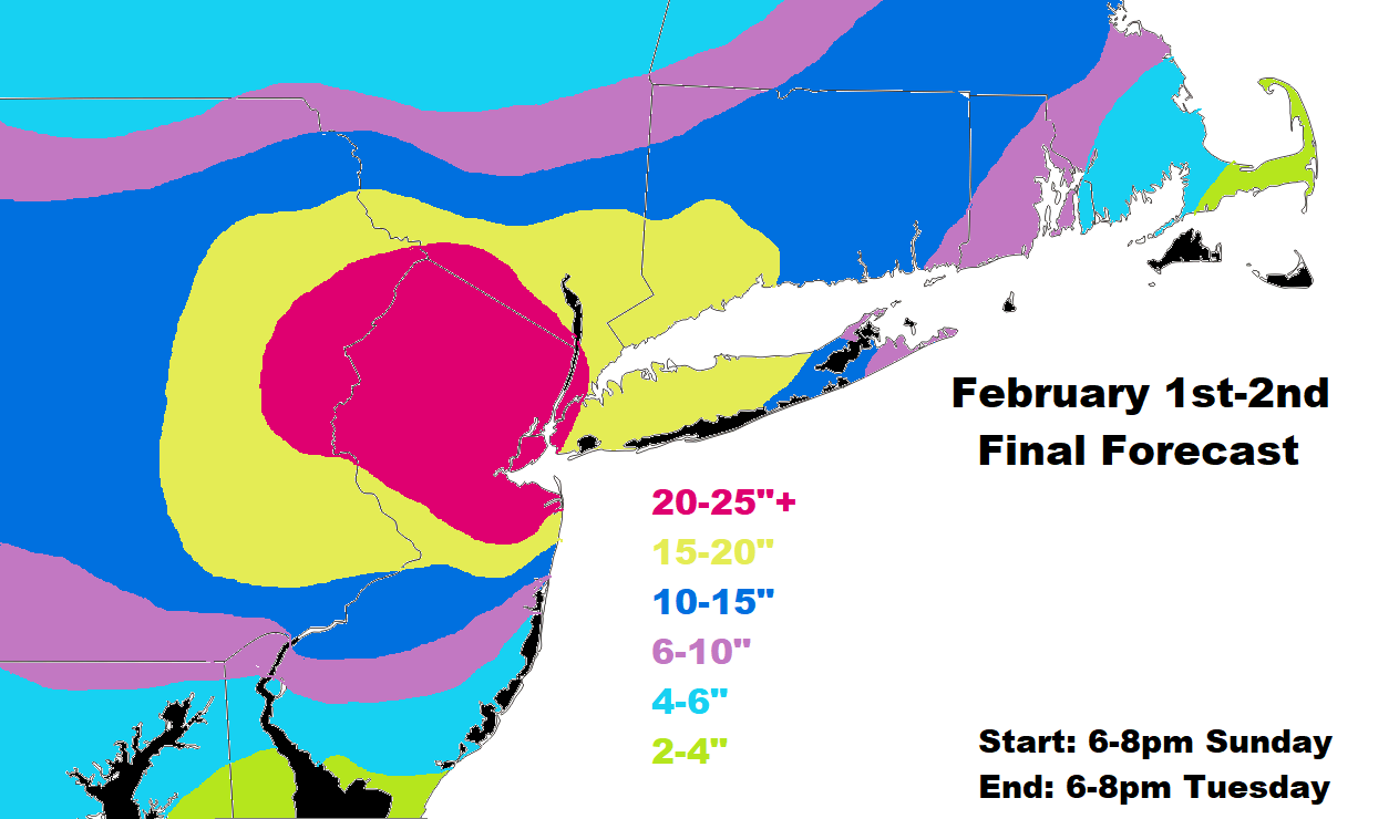
1. -NAO, or high latitude blocking, is extending the duration of this event from our typical 18-24 hours to almost 48 hours. Snow has already begun falling in places. Although the main part of the storm will end tomorrow night, there will be bands of snow still sitting over portions of this area all the way into Tuesday afternoon. Additional upper air vorticity phases into the mean trough late tomorrow night which expands the precipitation field of the system, and allows banding to reemerge on Tuesday. That will also be high-ratio snow and could tack on anywhere from 2 to as much as 5 additional inches in spots.
2. I can't get over the track of our mid-level low's (500mb, 700mb, 850mb). They track due south and then east of our area and that is as good as you will ever see. This either eliminates or significantly reduces a changeover to rain or dry slotting. While that remains a possibility since nothing is set in stone, I do believe the EURO and other models that track these lows off our coast instead of inland. Lower 500mb heights and a 250mb jet streak due east of Maine calls for a track of the SLP more east than where the RGEM (for example) has it. Therefore, my forecast heavily leans toward that idea.
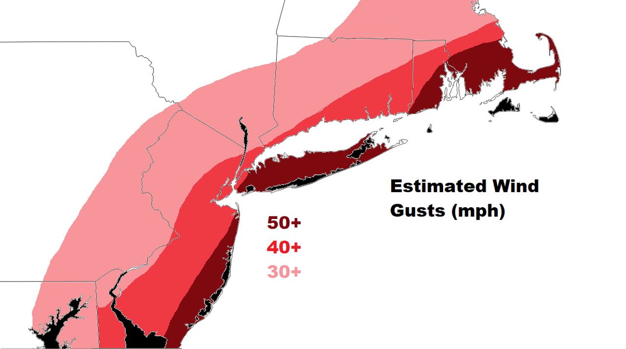
3. The dynamics at play are overwhelming to talk about without getting so giddy. A LLJ, low level jet, at 850mb is streamlining 100+ kt winds into the core of the storm. At the surface, this has potential to reach tropical storm force winds. I did create a wind map to give you an idea of where the strongest surface winds will be, and where blizzard conditions are likely. This LLJ will aid in fueling the eventual CCB that develops.
4. This could turn out to be a once every 5 year, or even decade, type of storm. It has been a blast tracking this one with all of you. As I type this and look out of my window, I can see my first flakes have began to fall. And that right there is perfect timing. Good luck everyone and please stay safe!!!!!!

_________________
_______________________________________________________________________________________________________
CLICK HERE to view NJ Strong Snowstorm Classifications

Frank_Wx- Godzilla Seeker

- Posts : 21305
Reputation : 328
Join date : 2013-01-05
Age : 32
Location : Jersey City, NJ -

CPcantmeasuresnow, SkiSeadooJoe, SNOW MAN, oldtimer, Grselig, Taffy, sabamfa and like this post
Re: February 1st-2nd Roidzilla, Part IV: Final Forecast
![]() by CDF24 Sun Jan 31, 2021 2:14 pm
by CDF24 Sun Jan 31, 2021 2:14 pm
CDF24- Posts : 7
Reputation : 0
Join date : 2017-09-08
Re: February 1st-2nd Roidzilla, Part IV: Final Forecast
![]() by jmanley32 Sun Jan 31, 2021 2:16 pm
by jmanley32 Sun Jan 31, 2021 2:16 pm

jmanley32- Senior Enthusiast

- Posts : 20535
Reputation : 108
Join date : 2013-12-12
Age : 43
Location : Yonkers, NY
Re: February 1st-2nd Roidzilla, Part IV: Final Forecast
![]() by billg315 Sun Jan 31, 2021 2:16 pm
by billg315 Sun Jan 31, 2021 2:16 pm

billg315- Advanced Forecaster - Mod

- Posts : 4483
Reputation : 185
Join date : 2015-01-24
Age : 50
Location : Flemington, NJ
Taffy likes this post
Re: February 1st-2nd Roidzilla, Part IV: Final Forecast
![]() by Frank_Wx Sun Jan 31, 2021 2:20 pm
by Frank_Wx Sun Jan 31, 2021 2:20 pm
The forum just hit 1,000 registered members. I know some folks have not posted in a long time, but this is a number worth celebrating considering we started out with like 20 of us back over at the Channel 7 Bill Evans board.
_________________
_______________________________________________________________________________________________________
CLICK HERE to view NJ Strong Snowstorm Classifications
Frank_Wx- Godzilla Seeker
- Posts : 21305
Reputation : 328
Join date : 2013-01-05
Age : 32
Location : Jersey City, NJ -
sroc4, amugs, CPcantmeasuresnow, oldtimer, HeresL, RJB8525, bloc1357 and like this post
Re: February 1st-2nd Roidzilla, Part IV: Final Forecast
![]() by frank 638 Sun Jan 31, 2021 2:21 pm
by frank 638 Sun Jan 31, 2021 2:21 pm
frank 638- Senior Enthusiast
- Posts : 2843
Reputation : 37
Join date : 2016-01-01
Age : 40
Location : bronx ny
Re: February 1st-2nd Roidzilla, Part IV: Final Forecast
![]() by larryrock72 Sun Jan 31, 2021 2:21 pm
by larryrock72 Sun Jan 31, 2021 2:21 pm

larryrock72- Posts : 140
Reputation : 5
Join date : 2017-01-03
Age : 52
Location : Barnegat, NJ
Taffy, mmillerc23, GreyBeard, weatherwatchermom and SENJsnowman like this post
Re: February 1st-2nd Roidzilla, Part IV: Final Forecast
![]() by jmanley32 Sun Jan 31, 2021 2:22 pm
by jmanley32 Sun Jan 31, 2021 2:22 pm
jmanley32- Senior Enthusiast
- Posts : 20535
Reputation : 108
Join date : 2013-12-12
Age : 43
Location : Yonkers, NY
Re: February 1st-2nd Roidzilla, Part IV: Final Forecast
![]() by Guest Sun Jan 31, 2021 2:23 pm
by Guest Sun Jan 31, 2021 2:23 pm
Guest- Guest
Re: February 1st-2nd Roidzilla, Part IV: Final Forecast
![]() by jmanley32 Sun Jan 31, 2021 2:23 pm
by jmanley32 Sun Jan 31, 2021 2:23 pm
we be crushed in yellow or red. Win win.frank 638 wrote:Thanks frank beautiful map I am happy for being in the boarder line of 20 to 25 inches of snow .stupid question will I have to worry about mixing in the Bronx and Yonkers
jmanley32- Senior Enthusiast
- Posts : 20535
Reputation : 108
Join date : 2013-12-12
Age : 43
Location : Yonkers, NY
Re: February 1st-2nd Roidzilla, Part IV: Final Forecast
![]() by CPcantmeasuresnow Sun Jan 31, 2021 2:25 pm
by CPcantmeasuresnow Sun Jan 31, 2021 2:25 pm

CPcantmeasuresnow- Wx Statistician Guru

- Posts : 7274
Reputation : 230
Join date : 2013-01-07
Age : 103
Location : Eastern Orange County, NY
Re: February 1st-2nd Roidzilla, Part IV: Final Forecast
![]() by Frank_Wx Sun Jan 31, 2021 2:25 pm
by Frank_Wx Sun Jan 31, 2021 2:25 pm
frank 638 wrote:Thanks frank beautiful map I am happy for being in the boarder line of 20 to 25 inches of snow .stupid question will I have to worry about mixing in the Bronx and Yonkers
No mixing
_________________
_______________________________________________________________________________________________________
CLICK HERE to view NJ Strong Snowstorm Classifications
Frank_Wx- Godzilla Seeker
- Posts : 21305
Reputation : 328
Join date : 2013-01-05
Age : 32
Location : Jersey City, NJ -
Re: February 1st-2nd Roidzilla, Part IV: Final Forecast
![]() by CPcantmeasuresnow Sun Jan 31, 2021 2:27 pm
by CPcantmeasuresnow Sun Jan 31, 2021 2:27 pm
Frank_Wx wrote:A milestone worth celebrating.
The forum just hit 1,000 registered members. I know some folks have not posted in a long time, but this is a number worth celebrating considering we started out with like 20 of us back over at the Channel 7 Bill Evans board.
It’s where we all initially Met. It was a fun board until the lunatics took over the asylum.
CPcantmeasuresnow- Wx Statistician Guru
- Posts : 7274
Reputation : 230
Join date : 2013-01-07
Age : 103
Location : Eastern Orange County, NY
bloc1357, Taffy and sabamfa like this post
Re: February 1st-2nd Roidzilla, Part IV: Final Forecast
![]() by frank 638 Sun Jan 31, 2021 2:28 pm
by frank 638 Sun Jan 31, 2021 2:28 pm
thank youFrank_Wx wrote:frank 638 wrote:Thanks frank beautiful map I am happy for being in the boarder line of 20 to 25 inches of snow .stupid question will I have to worry about mixing in the Bronx and Yonkers
No mixing
frank 638- Senior Enthusiast
- Posts : 2843
Reputation : 37
Join date : 2016-01-01
Age : 40
Location : bronx ny
Re: February 1st-2nd Roidzilla, Part IV: Final Forecast
![]() by colosa4 Sun Jan 31, 2021 2:28 pm
by colosa4 Sun Jan 31, 2021 2:28 pm
colosa4- Posts : 36
Reputation : 0
Join date : 2013-09-16
Location : Suffolk county/University at Buffalo
Taffy and lznachu like this post
Re: February 1st-2nd Roidzilla, Part IV: Final Forecast
![]() by frank 638 Sun Jan 31, 2021 2:29 pm
by frank 638 Sun Jan 31, 2021 2:29 pm
my fingers are crossedjmanley32 wrote:we be crushed in yellow or red. Win win.frank 638 wrote:Thanks frank beautiful map I am happy for being in the boarder line of 20 to 25 inches of snow .stupid question will I have to worry about mixing in the Bronx and Yonkers
frank 638- Senior Enthusiast
- Posts : 2843
Reputation : 37
Join date : 2016-01-01
Age : 40
Location : bronx ny
Re: February 1st-2nd Roidzilla, Part IV: Final Forecast
![]() by Grselig Sun Jan 31, 2021 2:32 pm
by Grselig Sun Jan 31, 2021 2:32 pm

Grselig- Senior Enthusiast
- Posts : 1408
Reputation : 140
Join date : 2013-03-04
Age : 54
Location : Wayne NJ
amugs likes this post
Re: February 1st-2nd Roidzilla, Part IV: Final Forecast
![]() by GreyBeard Sun Jan 31, 2021 2:34 pm
by GreyBeard Sun Jan 31, 2021 2:34 pm
GreyBeard- Senior Enthusiast
- Posts : 725
Reputation : 34
Join date : 2014-02-12
Location : eastern nassau county
Re: February 1st-2nd Roidzilla, Part IV: Final Forecast
![]() by Joe Snow Sun Jan 31, 2021 2:35 pm
by Joe Snow Sun Jan 31, 2021 2:35 pm
I just read Craig Allen's write up on Face book. Made excellent points, doesn't think the RPM (TV Met Model) handles coastal storms well.
Calls for an area wide 12"-18" but where ever the banding sets up it will be 2 feet or more, he rarely goes high on predictions like that but wow!
Also said in one of his videos could see thundersnow....
We are all looking forward to the epic snow storm.........
Last edited by Joe Snow on Sun Jan 31, 2021 2:36 pm; edited 1 time in total

Joe Snow- Pro Enthusiast

- Posts : 924
Reputation : 7
Join date : 2014-02-12
Age : 62
Location : Sanford Florida, Fmrly Kings Park, NY


SoulSingMG- Senior Enthusiast
- Posts : 2853
Reputation : 74
Join date : 2013-12-11
Location : Long Island City, NY
Re: February 1st-2nd Roidzilla, Part IV: Final Forecast
![]() by weatherwatchermom Sun Jan 31, 2021 2:43 pm
by weatherwatchermom Sun Jan 31, 2021 2:43 pm
Rooster89 wrote:Yeah I’ll take that firmly planted in the 20-25+ zone. My almost 5 year old and my 3 year old have not seen a real snow yet and this is looking like it.
Hey where are you, I think we are close.

weatherwatchermom- Senior Enthusiast
- Posts : 3793
Reputation : 78
Join date : 2014-11-25
Location : Hazlet Township, NJ
Re: February 1st-2nd Roidzilla, Part IV: Final Forecast
![]() by GreyBeard Sun Jan 31, 2021 2:44 pm
by GreyBeard Sun Jan 31, 2021 2:44 pm
GreyBeard- Senior Enthusiast
- Posts : 725
Reputation : 34
Join date : 2014-02-12
Location : eastern nassau county
Re: February 1st-2nd Roidzilla, Part IV: Final Forecast
![]() by heehaw453 Sun Jan 31, 2021 2:45 pm
by heehaw453 Sun Jan 31, 2021 2:45 pm
CPcantmeasuresnow wrote:TWC app, as always meAningless but still fun to track just for shots and giggles just updated to 20-31 inches for my town, highland mills 45 miles due north of midtown. Yesterday morning I was at 2-6 inches.
lol
heehaw453- Advanced Forecaster

- Posts : 3906
Reputation : 86
Join date : 2014-01-20
Location : Bedminster Township, PA Elevation 600' ASL
Re: February 1st-2nd Roidzilla, Part IV: Final Forecast
![]() by heehaw453 Sun Jan 31, 2021 2:46 pm
by heehaw453 Sun Jan 31, 2021 2:46 pm
23/20
heehaw453- Advanced Forecaster
- Posts : 3906
Reputation : 86
Join date : 2014-01-20
Location : Bedminster Township, PA Elevation 600' ASL
Re: February 1st-2nd Roidzilla, Part IV: Final Forecast
![]() by Guest Sun Jan 31, 2021 2:48 pm
by Guest Sun Jan 31, 2021 2:48 pm
weatherwatchermom wrote:Rooster89 wrote:Yeah I’ll take that firmly planted in the 20-25+ zone. My almost 5 year old and my 3 year old have not seen a real snow yet and this is looking like it.
Hey where are you, I think we are close.
Middletown.
Guest- Guest
Page 1 of 29 • 1, 2, 3 ... 15 ... 29 ![]()
|
|
|