February 1st-2nd Roidzilla, Part IV: Final Forecast
+75
sabamfa
AlphaOrionis42
essexcountypete
kcarnegie275
Artechmetals
richb521
Dunnzoo
crippo84
SNOW MAN
jbnyy224
dfig529
elkiehound
SkiSeadooJoe
phil155
nutleyblizzard
kalleg
Radz
docstox12
snowlover78
sroc4
Sparky Sparticles
Taffy
dkodgis
jaydoy
2004blackwrx
marin1804
hyde345
dsix85
stAtic9
gigs68
Zhukov1945
Scullybutcher
Mike1984
oldtimer
rb924119
1190ftalt
AMD95
aiannone
snowday111
Irish
Snownyc
Math23x7
mmanisca
adamfitz1969
algae888
Fededle22
mwilli
Gator99
brownie
Vinnydula
lglickman1
SENJsnowman
emokid51783
bloc1357
lznachu
CnWestMilford76
WeatherBob
jtswife
amugs
Angela0621
DAYBLAZER
heehaw453
weatherwatchermom
SoulSingMG
Joe Snow
GreyBeard
Grselig
colosa4
CPcantmeasuresnow
larryrock72
frank 638
billg315
jmanley32
CDF24
Frank_Wx
79 posters
Page 2 of 29
Page 2 of 29 •  1, 2, 3 ... 15 ... 29
 Re: February 1st-2nd Roidzilla, Part IV: Final Forecast
1" otg. snowing moderately.
23/20
23/20
heehaw453- Advanced Forecaster

- Posts : 3906
Join date : 2014-01-20
 Re: February 1st-2nd Roidzilla, Part IV: Final Forecast
weatherwatchermom wrote:Rooster89 wrote:Yeah I’ll take that firmly planted in the 20-25+ zone. My almost 5 year old and my 3 year old have not seen a real snow yet and this is looking like it.
Hey where are you, I think we are close.
Middletown.
Guest- Guest
 Re: February 1st-2nd Roidzilla, Part IV: Final Forecast
Cherish this moment, ladies and gentlemen. We do not get this type of opportunity often, and it is the whole reason why all of us signed up for this wonderful forum in the first place.
Frank, hats off to you for all you've done to provide this space for all of us to gather and discuss events like this. It's a wonderful thing.
Now let's do this.
Frank, hats off to you for all you've done to provide this space for all of us to gather and discuss events like this. It's a wonderful thing.
Now let's do this.

DAYBLAZER- Posts : 228
Reputation : 20
Join date : 2017-03-12
Location : Hopatcong, NJ Sussex County
Frank_Wx, dolphins222, heehaw453, weatherwatchermom, JACKZO, larryrock72, SENJsnowman and Zhukov1945 like this post
 Re: February 1st-2nd Roidzilla, Part IV: Final Forecast
heehaw453 wrote:1" otg. snowing moderately.
23/20
What's the 23/20 mean?
GreyBeard- Senior Enthusiast

- Posts : 725
Reputation : 34
Join date : 2014-02-12
Location : eastern nassau county
 Re: February 1st-2nd Roidzilla, Part IV: Final Forecast
Can someone tell me the general timing for the storm? My daughter works for the post office and we are trying to figure out of she should bring my grandson to me tonight or wait until the morning. Will it still be safe to venture out in the morning like say 7am? We are in Eatontown Monmouth county

Angela0621- Posts : 43
Reputation : 0
Join date : 2013-11-08
Location : Eatontown, NJ
 Re: February 1st-2nd Roidzilla, Part IV: Final Forecast
Rooster89 wrote: Middletown.
My hometown! Grew up in the neighborhood next to HS South, class of 2010. My parents still live down there. Good stuff! Hope you cash in!

DAYBLAZER- Posts : 228
Reputation : 20
Join date : 2017-03-12
Location : Hopatcong, NJ Sussex County
weatherwatchermom likes this post
 Re: February 1st-2nd Roidzilla, Part IV: Final Forecast
Angela0621 wrote:Can someone tell me the general timing for the storm? My daughter works for the post office and we are trying to figure out of she should bring my grandson to me tonight or wait until the morning. Will it still be safe to venture out in the morning like say 7am? We are in Eatontown Monmouth county
Tonight is the answer. Morning will not be possible.
_________________
_______________________________________________________________________________________________________
CLICK HERE to view NJ Strong Snowstorm Classifications
Angela0621 likes this post
 Re: February 1st-2nd Roidzilla, Part IV: Final Forecast
@Frank_Wx Great call and you have the Riodzilla in full effect as we said lets wait and pull the trigger after teh 12Z and here we have it!
One for the ages folks.
One for the ages folks.
_________________
Mugs
AKA:King: Snow Weenie
Self Proclaimed
WINTER 2014-15 : 55.12" +.02 for 6 coatings (avg. 35")
WINTER 2015-16 Total - 29.8" (Avg 35")
WINTER 2016-17 : 39.5" so far

amugs- Advanced Forecaster - Mod

- Posts : 15095
Reputation : 213
Join date : 2013-01-07
Age : 54
Location : Hillsdale,NJ
Frank_Wx likes this post
 Re: February 1st-2nd Roidzilla, Part IV: Final Forecast
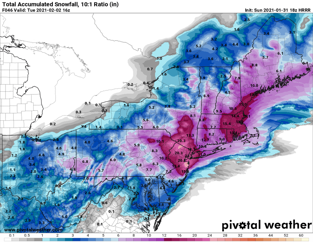
HRRR


_________________
_______________________________________________________________________________________________________
CLICK HERE to view NJ Strong Snowstorm Classifications
heehaw453- Advanced Forecaster

- Posts : 3906
Reputation : 86
Join date : 2014-01-20
Location : Bedminster Township, PA Elevation 600' ASL
 Re: February 1st-2nd Roidzilla, Part IV: Final Forecast
Thanks to all of you for your information. This forum is where I come when I need reliable info. Appreciate you all!! I live on the south shore of Long Island in west islip. Do you think we will be getting mixing here?
Last edited by jtswife on Sun Jan 31, 2021 2:59 pm; edited 1 time in total

jtswife- Posts : 81
Reputation : 0
Join date : 2013-01-13
Location : Port Charlotte Florida, from long island
 Re: February 1st-2nd Roidzilla, Part IV: Final Forecast
GreyBeard wrote:heehaw453 wrote:1" otg. snowing moderately.
23/20
What's the 23/20 mean?
temp/dew point
heehaw453- Advanced Forecaster

- Posts : 3906
Reputation : 86
Join date : 2014-01-20
Location : Bedminster Township, PA Elevation 600' ASL
GreyBeard likes this post
 Re: February 1st-2nd Roidzilla, Part IV: Final Forecast
18z NAM is rolling
Here is 700mb. Remember we want the center to stay to our south and east. Let's see where the NAM takes it

Here is 700mb. Remember we want the center to stay to our south and east. Let's see where the NAM takes it

_________________
_______________________________________________________________________________________________________
CLICK HERE to view NJ Strong Snowstorm Classifications
 Re: February 1st-2nd Roidzilla, Part IV: Final Forecast
Now here is 850mb winds on the 18z NAM, or low level jet. I mean, COME ON!!! MADONNE


_________________
_______________________________________________________________________________________________________
CLICK HERE to view NJ Strong Snowstorm Classifications
 Re: February 1st-2nd Roidzilla, Part IV: Final Forecast
Frank_Wx wrote:HRRR
Looking at the HRRR on Long Island we get sleet across the entire Island around 3-4 Monday afternoon............... Not Happy about that

Joe Snow- Pro Enthusiast

- Posts : 924
Reputation : 7
Join date : 2014-02-12
Age : 62
Location : Sanford Florida, Fmrly Kings Park, NY
 Re: February 1st-2nd Roidzilla, Part IV: Final Forecast
Wind gusts at the surface per 18z NAM
.png.0ecff814bb90ca98043e2b789f2d6f6d.png)
.png.0ecff814bb90ca98043e2b789f2d6f6d.png)
_________________
_______________________________________________________________________________________________________
CLICK HERE to view NJ Strong Snowstorm Classifications
 Re: February 1st-2nd Roidzilla, Part IV: Final Forecast
Isn’t the HRRR model the best short range model that NOAA has?

WeatherBob- Meteorologist

- Posts : 683
Reputation : 83
Join date : 2013-12-13
Location : Caldwell, NJ - NW Essex County - Altitude 500 FT
 Re: February 1st-2nd Roidzilla, Part IV: Final Forecast
Frank_Wx wrote:Wind gusts at the surface per 18z NAM
Yikes. Talk about Total Whiteout conditions.

billg315- Advanced Forecaster - Mod

- Posts : 4483
Reputation : 185
Join date : 2015-01-24
Age : 50
Location : Flemington, NJ
 Re: February 1st-2nd Roidzilla, Part IV: Final Forecast
Frank_Wx wrote:18z NAM is rolling
Here is 700mb. Remember we want the center to stay to our south and east. Let's see where the NAM takes it
Looks like it develops around Cape May and is moving due north. That means SNJ/CNJ would get into either some mix or dry slot (per NAM). Let's see where it goes from here

_________________
_______________________________________________________________________________________________________
CLICK HERE to view NJ Strong Snowstorm Classifications
 Re: February 1st-2nd Roidzilla, Part IV: Final Forecast
WeatherBob wrote:Isn’t the HRRR model the best short range model that NOAA has?
Yes but I only use it for hours 1 to 12.
Anything beyond 12 hours is volatile
_________________
_______________________________________________________________________________________________________
CLICK HERE to view NJ Strong Snowstorm Classifications
 Re: February 1st-2nd Roidzilla, Part IV: Final Forecast
NAM is cutting down the dry slot north of 195 in NJ. That will be critical and determines who gets the insane amounts.
heehaw453- Advanced Forecaster

- Posts : 3906
Reputation : 86
Join date : 2014-01-20
Location : Bedminster Township, PA Elevation 600' ASL
 Re: February 1st-2nd Roidzilla, Part IV: Final Forecast
YOU CAN NOT ASK FOR BETER PEEPS - I MEAN JUST INCREDIBLE!
700MB SE OF NYC = ANNHILATION
.gif.a5cd3937e73dc579b267872032748b35.gif)
700MB SE OF NYC = ANNHILATION
.gif.a5cd3937e73dc579b267872032748b35.gif)
_________________
Mugs
AKA:King: Snow Weenie
Self Proclaimed
WINTER 2014-15 : 55.12" +.02 for 6 coatings (avg. 35")
WINTER 2015-16 Total - 29.8" (Avg 35")
WINTER 2016-17 : 39.5" so far

amugs- Advanced Forecaster - Mod

- Posts : 15095
Reputation : 213
Join date : 2013-01-07
Age : 54
Location : Hillsdale,NJ
 Re: February 1st-2nd Roidzilla, Part IV: Final Forecast
This is how much precip has fallen so far on the NAM (through 4pm tomorrow)


_________________
_______________________________________________________________________________________________________
CLICK HERE to view NJ Strong Snowstorm Classifications
 Re: February 1st-2nd Roidzilla, Part IV: Final Forecast
Frank_Wx wrote:WeatherBob wrote:Isn’t the HRRR model the best short range model that NOAA has?
Yes but I only use it for hours 1 to 12.
Anything beyond 12 hours is volatile
Got ya Thanks Frank

Joe Snow- Pro Enthusiast

- Posts : 924
Reputation : 7
Join date : 2014-02-12
Age : 62
Location : Sanford Florida, Fmrly Kings Park, NY
 Re: February 1st-2nd Roidzilla, Part IV: Final Forecast
The latest 48-hour HRRR puts northern NJ, southern NY & northeast PA in the "sweet spot" of heavy snow bands on Monday
— Ben Noll (@BenNollWeather) January 31, 2021️
Snow rates could reach 2-3 inches per hour at times during the afternoon.
Yellow outline <=> potential for 1 foot
Orange outline <=> potential for 2 feet pic.twitter.com/DexhvxUTQZ
_________________
_______________________________________________________________________________________________________
CLICK HERE to view NJ Strong Snowstorm Classifications
 Re: February 1st-2nd Roidzilla, Part IV: Final Forecast
Frank_Wx wrote:Wind gusts at the surface per 18z NAM
This will likely cause NWS to insure blizzard warnings.
CnWestMilford76- Posts : 30
Reputation : 0
Join date : 2020-12-15
 Re: February 1st-2nd Roidzilla, Part IV: Final Forecast
And I say again, I think the Euro has the best handle on this storm. I still think the NAM is struggling with the placement and evolution.
heehaw453- Advanced Forecaster

- Posts : 3906
Reputation : 86
Join date : 2014-01-20
Location : Bedminster Township, PA Elevation 600' ASL
Page 2 of 29 •  1, 2, 3 ... 15 ... 29
Page 2 of 29
Permissions in this forum:
You cannot reply to topics in this forum|
|
|

 Home
Home
