March 2021 Observations and Discussions
+21
algae888
SENJsnowman
richb521
billg315
skinsfan1177
Dunnzoo
essexcountypete
aiannone
weatherwatchermom
dsix85
kalleg
GreyBeard
sroc4
docstox12
dkodgis
Radz
frank 638
amugs
heehaw453
Frank_Wx
CPcantmeasuresnow
25 posters
Page 4 of 6 •  1, 2, 3, 4, 5, 6
 Re: March 2021 Observations and Discussions
Beautiful March Weather - Rain to wet Snow but maybe icy conditions Thursday night
12Z GFS

Temps - if correct they crash

12Z GFS

Temps - if correct they crash

amugs- Advanced Forecaster - Mod

- Posts : 15095
Join date : 2013-01-07
 Re: March 2021 Observations and Discussions
Yeah looks like that Thursday rain could end as a period of snow by Friday A.M.
billg315- Advanced Forecaster - Mod

- Posts : 4483
Join date : 2015-01-24
 Re: March 2021 Observations and Discussions
GFS has rain Thursday afternoon and evening changing to snow from NW to SE around midnight and continuing until about rush hour Friday morning before ending. Surface temps wouldn't hit freezing until almost dawn so not sure how much would stick. Probably depend on intensity but could see it coating the ground to maybe an inch or two in some colder spots.

billg315- Advanced Forecaster - Mod

- Posts : 4483
Reputation : 185
Join date : 2015-01-24
Age : 50
Location : Flemington, NJ
 Re: March 2021 Observations and Discussions
Chances of any accumulation would be helped a bit by the change to snow happening in the middle of the night, since sun angle would be an issue during the daytime.

billg315- Advanced Forecaster - Mod

- Posts : 4483
Reputation : 185
Join date : 2015-01-24
Age : 50
Location : Flemington, NJ
 Re: March 2021 Observations and Discussions
I got hit with a microburst of hail last night around 11:30 pm or so (GSP, exit 80). It was really intense and lasted for only about a minute or so. I was scared/fascinated by it! Anyone else catch any part of that? It was short! If you were up and on a pee break, you missed it! lol
Also, TWC has me for 1" on Friday?? I believe Friday is the last day of met winter and Saturday is the first day of spring. I don't recall snowfall on the actual last day of winter, but I do remember a first day of spring snowstorm I think in 2016 or 2017. We plowed our way through the snow and still made it to Rita's* that day though...lol!!!
*Rita's Italian Ices- they (used to!) give a free Italian ice on the first day of spring every year. I'm not sure if they're a Shore thing or how region-wide they are...
SENJsnowman- Senior Enthusiast

- Posts : 1189
Reputation : 61
Join date : 2017-01-06
Age : 51
Location : Bayville, NJ
 Re: March 2021 Observations and Discussions
SENJsnowman wrote:I got hit with a microburst of hail last night around 11:30 pm or so (GSP, exit 80). It was really intense and lasted for only about a minute or so. I was scared/fascinated by it! Anyone else catch any part of that? It was short! If you were up and on a pee break, you missed it! lol
Also, TWC has me for 1" on Friday?? I believe Friday is the last day of met winter and Saturday is the first day of spring. I don't recall snowfall on the actual last day of winter, but I do remember a first day of spring snowstorm I think in 2016 or 2017. We plowed our way through the snow and still made it to Rita's* that day though...lol!!!
*Rita's Italian Ices- they (used to!) give a free Italian ice on the first day of spring every year. I'm not sure if they're a Shore thing or how region-wide they are...
There is or was a Rita's up in Mahwah NJ when I still lived there in 2014.

docstox12- Wx Statistician Guru

- Posts : 8530
Reputation : 222
Join date : 2013-01-07
Age : 73
Location : Monroe NY
 Re: March 2021 Observations and Discussions
New Hope update: There's a Rita's less than a mile from my house, many more in this part of the world and around NJ. Maybe one close to you as well--here's the link to find their locations: https://www.ritasice.com/locations/
kalleg- Posts : 148
Reputation : 2
Join date : 2013-01-15
Location : New Hope, PA
 Re: March 2021 Observations and Discussions
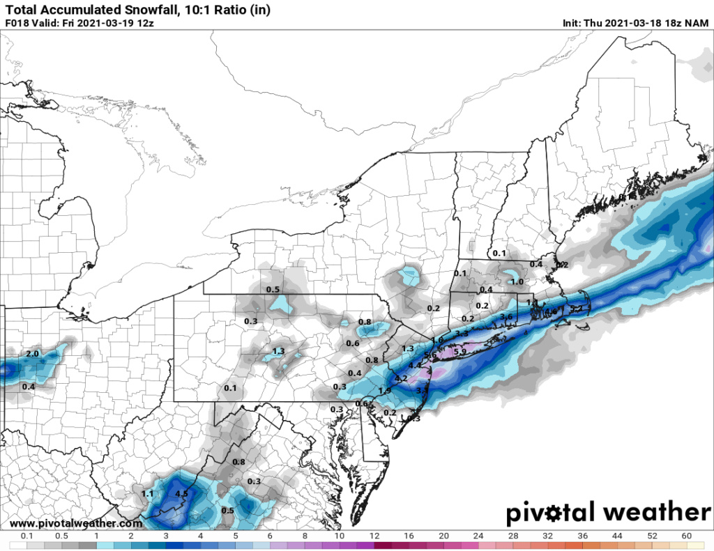
All of the models show or hint at a changeover to snow at the end of the storm Friday morning to some extent or another. The GFS is a little more bullish than the Euro/NAM on intensity north of I-195. None really show more than a coating to an inch type event. It would be more the aesthetics of waking up to snow falling in the morning Friday than the accumulation impact. The exception is the South Jersey coast and Delmarva where the models seem to imply the cold air will catch up to the heavier precip before it departs and allow for the chance for actual accumulation. NAM and GFS have 2-3" across parts of the South Jersey shore (whether that can actually stick I wonder). Euro only shows a coating type event down there. GFS actually has 3-6" in parts of the Delmarva, which would be interesting.

billg315- Advanced Forecaster - Mod

- Posts : 4483
Reputation : 185
Join date : 2015-01-24
Age : 50
Location : Flemington, NJ
 Re: March 2021 Observations and Discussions
Severe weather threat caused me to change my plans for coming home Thursday. Southern states and the SE are going to get crushed! Supposed to take the autotrain from Florida, but no way with the high risk of tornadoes! Postponing til Friday, there are worse places I could get stuck! 

_________________
Janet
Snowfall winter of 2023-2024 17.5"
Snowfall winter of 2022-2023 6.0"
Snowfall winter of 2021-2022 17.6" 1" sleet 2/25/22
Snowfall winter of 2020-2021 51.1"
Snowfall winter of 2019-2020 8.5"
Snowfall winter of 2018-2019 25.1"
Snowfall winter of 2017-2018 51.9"
Snowfall winter of 2016-2017 45.6"
Snowfall winter of 2015-2016 29.5"
Snowfall winter of 2014-2015 50.55"
Snowfall winter of 2013-2014 66.5"
Dunnzoo- Senior Enthusiast - Mod

- Posts : 4905
Reputation : 68
Join date : 2013-01-11
Age : 62
Location : Westwood, NJ
brownie and weatherwatchermom like this post
 Re: March 2021 Observations and Discussions
Dunnzoo wrote:Severe weather threat caused me to change my plans for coming home Thursday. Southern states and the SE are going to get crushed! Supposed to take the autotrain from Florida, but no way with the high risk of tornadoes! Postponing til Friday, there are worse places I could get stuck!
Was going to say, there are definitely worse places to have to spend an extra day!

billg315- Advanced Forecaster - Mod

- Posts : 4483
Reputation : 185
Join date : 2015-01-24
Age : 50
Location : Flemington, NJ
 Re: March 2021 Observations and Discussions
12z GFS just stepped things up a bit for Friday A.M. Showing a general 1-2" snowfall with isolated 3-4" spots well north and west after the changeover to snow. Rain begins changing to snow by 3 or 4 a.m. as Temps crash and continues into early afternoon. Temps at the surface go below freezing by dawn so if snow is still falling it may be able to accumulate before the sun comes up (which is a factor this time of year).
Again, not saying this is a major event, just that if the GFS is right, snow could impact the AM rush hour Friday.
Again, not saying this is a major event, just that if the GFS is right, snow could impact the AM rush hour Friday.

billg315- Advanced Forecaster - Mod

- Posts : 4483
Reputation : 185
Join date : 2015-01-24
Age : 50
Location : Flemington, NJ
 Re: March 2021 Observations and Discussions
This has been trending colder each run by about 35 miles each time. EURO is either on crack of onto something following the GFS - about 1.5" of rain before this change over but temps crash after midnight Thursday into Friday morning - C -3" (highest elevations possible 3" max)


_________________
Mugs
AKA:King: Snow Weenie
Self Proclaimed
WINTER 2014-15 : 55.12" +.02 for 6 coatings (avg. 35")
WINTER 2015-16 Total - 29.8" (Avg 35")
WINTER 2016-17 : 39.5" so far

amugs- Advanced Forecaster - Mod

- Posts : 15095
Reputation : 213
Join date : 2013-01-07
Age : 54
Location : Hillsdale,NJ
 Re: March 2021 Observations and Discussions
The NAM this morning, which is now in range to be the more reliable model, has now picked up on the cold/snowy trend. It has the changeover to snow starting by midnight and snow continuing until about 9 a.m. or so. Surface temps start to drop below freezing by 2 a.m. Under that circumstance, snow, at night, with surface freezing, I think we would see accumulation by dawn.
Verbatim 06z NAM has a swath of 2-4" of snow from Upper Bucks PA through Northwest and North Jersey into the lower-mid Hudson Valley. Just south and east of that is a coating to an inch in lower northern NJ and NYC proper.
Verbatim 06z NAM has a swath of 2-4" of snow from Upper Bucks PA through Northwest and North Jersey into the lower-mid Hudson Valley. Just south and east of that is a coating to an inch in lower northern NJ and NYC proper.

billg315- Advanced Forecaster - Mod

- Posts : 4483
Reputation : 185
Join date : 2015-01-24
Age : 50
Location : Flemington, NJ
 Re: March 2021 Observations and Discussions
The 0z HRRR was similar but it brought the coating to an inch of snow all the way south into South Jersey.

billg315- Advanced Forecaster - Mod

- Posts : 4483
Reputation : 185
Join date : 2015-01-24
Age : 50
Location : Flemington, NJ
 Re: March 2021 Observations and Discussions
12z NAM back off on the "snowier" solution from its last run. I think this is one of those nowcast situations as it will be highly dependent on how fast the temps crash overnight vs how fast the precip moves out. Most of this will happen while we sleep so either you wake up to a nice little surprise tomorrow morning of some snowflakes flying and maybe a fresh coating on the ground, or you wake up to cloudy skies and cold temps with some icy patches on the wet surfaces. Gives you a mystery to look forward to. 

billg315- Advanced Forecaster - Mod

- Posts : 4483
Reputation : 185
Join date : 2015-01-24
Age : 50
Location : Flemington, NJ

aiannone- Senior Enthusiast - Mod

- Posts : 4815
Reputation : 92
Join date : 2013-01-07
Location : Saint James, LI (Northwest Suffolk Co.)
 Re: March 2021 Observations and Discussions
UPTON's take:
Behind the front, cold air will filter in throughout the night.
This will change any rain to a rain/snow mix, then all snow from
northwest to southeast. Sleet may briefly mix in as well before
a complete change over to snow. While a changeover to all snow
is expected, even along the coast, much of the precipitation
will be on its way out while the transition is occurring for
most places for any real accumulating snow. The best chances for
any accumulating snow is across northern Lower Hudson Valley
and inland southern Connecticut. 1 to 2 inches is possible in
these areas, while under an inch is expected elsewhere. Little
or no snow is expected for New York City and Long Island.
There is a slight chance for light snow early Friday morning for
the New York City metro area and Long Island, but again, no
accumulation is expected. Dry conditions are then forecast mid
Friday morning onward as high pressure builds in from the
northwest. Clouds will diminish, with mostly clear skies by the
afternoon.
_________________
"In weather and in life, there's no winning and losing; there's only winning and learning."
WINTER 2012/2013 TOTALS 43.65"WINTER 2017/2018 TOTALS 62.85" WINTER 2022/2023 TOTALS 4.9"
WINTER 2013/2014 TOTALS 64.85"WINTER 2018/2019 TOTALS 14.25" WINTER 2023/2024 TOTALS 13.1"
WINTER 2014/2015 TOTALS 71.20"WINTER 2019/2020 TOTALS 6.35"
WINTER 2015/2016 TOTALS 35.00"WINTER 2020/2021 TOTALS 37.75"
WINTER 2016/2017 TOTALS 42.25"WINTER 2021/2022 TOTALS 31.65"

sroc4- Admin

- Posts : 8354
Reputation : 302
Join date : 2013-01-07
Location : Wading River, LI
 Re: March 2021 Observations and Discussions
_________________
-Alex Iannone-

aiannone- Senior Enthusiast - Mod

- Posts : 4815
Reputation : 92
Join date : 2013-01-07
Location : Saint James, LI (Northwest Suffolk Co.)
 Re: March 2021 Observations and Discussions
The latest HRRR and NAM Show the last impulse moving in between 2 and 8:00 a.m. and actually favors Long Island

algae888- Advanced Forecaster

- Posts : 5311
Reputation : 46
Join date : 2013-02-05
Age : 62
Location : mt. vernon, new york
 Re: March 2021 Observations and Discussions
Snow line developing in the mountains 1st then push SE


_________________
Mugs
AKA:King: Snow Weenie
Self Proclaimed
WINTER 2014-15 : 55.12" +.02 for 6 coatings (avg. 35")
WINTER 2015-16 Total - 29.8" (Avg 35")
WINTER 2016-17 : 39.5" so far

amugs- Advanced Forecaster - Mod

- Posts : 15095
Reputation : 213
Join date : 2013-01-07
Age : 54
Location : Hillsdale,NJ
 Re: March 2021 Observations and Discussions
Did anyone get any snow? Had thunderstorms roll through here last night. 

_________________
Janet
Snowfall winter of 2023-2024 17.5"
Snowfall winter of 2022-2023 6.0"
Snowfall winter of 2021-2022 17.6" 1" sleet 2/25/22
Snowfall winter of 2020-2021 51.1"
Snowfall winter of 2019-2020 8.5"
Snowfall winter of 2018-2019 25.1"
Snowfall winter of 2017-2018 51.9"
Snowfall winter of 2016-2017 45.6"
Snowfall winter of 2015-2016 29.5"
Snowfall winter of 2014-2015 50.55"
Snowfall winter of 2013-2014 66.5"

Dunnzoo- Senior Enthusiast - Mod

- Posts : 4905
Reputation : 68
Join date : 2013-01-11
Age : 62
Location : Westwood, NJ
 Re: March 2021 Observations and Discussions
I thought we were supposed to have a lot of rain...nothing to write home about and def no flakes..low 35* and winds sustained at 12-15 we had a couple of gusts this morning in the mid 20's heard our area mentioned on news last night to get gusts to 50 let's see

weatherwatchermom- Senior Enthusiast

- Posts : 3793
Reputation : 78
Join date : 2014-11-25
Location : Hazlet Township, NJ
 Re: March 2021 Observations and Discussions
not even a flakeDunnzoo wrote:Did anyone get any snow? Had thunderstorms roll through here last night.
frank 638- Senior Enthusiast

- Posts : 2843
Reputation : 37
Join date : 2016-01-01
Age : 40
Location : bronx ny
 Re: March 2021 Observations and Discussions
So let it be written, so let it be done.


_________________
"In weather and in life, there's no winning and losing; there's only winning and learning."
WINTER 2012/2013 TOTALS 43.65"WINTER 2017/2018 TOTALS 62.85" WINTER 2022/2023 TOTALS 4.9"
WINTER 2013/2014 TOTALS 64.85"WINTER 2018/2019 TOTALS 14.25" WINTER 2023/2024 TOTALS 13.1"
WINTER 2014/2015 TOTALS 71.20"WINTER 2019/2020 TOTALS 6.35"
WINTER 2015/2016 TOTALS 35.00"WINTER 2020/2021 TOTALS 37.75"
WINTER 2016/2017 TOTALS 42.25"WINTER 2021/2022 TOTALS 31.65"

sroc4- Admin

- Posts : 8354
Reputation : 302
Join date : 2013-01-07
Location : Wading River, LI
kalleg, weatherwatchermom, billg315 and SENJsnowman like this post
 Re: March 2021 Observations and Discussions
Agreed. I think I’ve seen my last snowflakes of the season. Onto Spring.

billg315- Advanced Forecaster - Mod

- Posts : 4483
Reputation : 185
Join date : 2015-01-24
Age : 50
Location : Flemington, NJ
weatherwatchermom likes this post
 Re: March 2021 Observations and Discussions
No new snow here at all. Although I still have piles of it in my front yard.
brownie- Posts : 393
Reputation : 17
Join date : 2013-11-10
Location : Parsippany, NJ
 Re: March 2021 Observations and Discussions
I love the snow and cold I hate to say this but let’s just MoveOn to spring and summer at least things are starting to open up at least we can attend to Yankee and mets game beach fishing bbq and moresroc4 wrote:So let it be written, so let it be done.
frank 638- Senior Enthusiast

- Posts : 2843
Reputation : 37
Join date : 2016-01-01
Age : 40
Location : bronx ny
sroc4 likes this post
Page 4 of 6 •  1, 2, 3, 4, 5, 6
Permissions in this forum:
You cannot reply to topics in this forum|
|
|

 Home
Home
