
 Search
Long Range Discussion 22.0
Page 12 of 31 •  1 ... 7 ... 11, 12, 13 ... 21 ... 31
 ![]()
Re: Long Range Discussion 22.0
![]() by rb924119 Tue Dec 14, 2021 7:42 pm
by rb924119 Tue Dec 14, 2021 7:42 pm
On top of that, this is a PHENOMENAL thread that deserves a read. Same results, slightly different angle of analysis:
rb924119- Meteorologist

- Posts : 6890
Join date : 2013-02-06
MattyICE likes this post
Re: Long Range Discussion 22.0
![]() by amugs Tue Dec 14, 2021 8:52 pm
by amugs Tue Dec 14, 2021 8:52 pm
amugs- Advanced Forecaster - Mod

- Posts : 15093
Join date : 2013-01-07
rb924119 likes this post
Re: Long Range Discussion 22.0
![]() by heehaw453 Wed Dec 15, 2021 2:29 pm
by heehaw453 Wed Dec 15, 2021 2:29 pm
heehaw453- Advanced Forecaster

- Posts : 3906
Reputation : 86
Join date : 2014-01-20
Location : Bedminster Township, PA Elevation 600' ASL
Re: Long Range Discussion 22.0
![]() by rb924119 Wed Dec 15, 2021 3:46 pm
by rb924119 Wed Dec 15, 2021 3:46 pm
heehaw453 wrote:Persistent -PNA trough over west coast making models stingy w.r.t. showing snow in the next 7 days. There is evidence of Atlantic blocking in the mid range along with with a -AO. My thought is we can still manage to get a small scale type of event before Christmas. That PNA must relax a bit before we start thinking anything beyond that type of small scale event IMO. The EPO though is definitely not going to give us the bad air mass we had last year. Night and day differences there. So overall it looks positive, but i say again the PAC has been a thorn in the ass.
Patience, heehaw - it’ll happen. The ensembles are showing the exact changes we need to see, that I mentioned last night. Starting from about December 29th or 30th, we should start to see the ensembles beginning to correct to progressively more +PNA/-EPO/-WPO triplet, and more eastern U.S. trough in the time-mean. New Year, new pattern. We just have to stay the course for now my friend, and trust the process
Also of importance: note the latest MJO forecasts are longer and stronger in Phase 7. This will provide some resistance at first, so the usual caveats to a “step-down” process apply (back and forth), and I like the true transition for our sensible weather to hold off a bit until approximately Week 2 of January (say, after the 6th). But while it’ll be a foe early, it’s going to be our friend later, as it should maintain an overall higher amplitude through later phases longer (higher starting point). Additionally, the longer/stronger Phase 7 will continue disrupt the Stratospheric PV, which again, based on the orientation of that disruption, will help us down the road. LOTS to be upbeat about in the extended.
rb924119- Meteorologist
- Posts : 6890
Reputation : 194
Join date : 2013-02-06
Age : 32
Location : Greentown, Pa
amugs and MattyICE like this post
Re: Long Range Discussion 22.0
![]() by heehaw453 Wed Dec 15, 2021 3:56 pm
by heehaw453 Wed Dec 15, 2021 3:56 pm
rb924119 wrote:heehaw453 wrote:Persistent -PNA trough over west coast making models stingy w.r.t. showing snow in the next 7 days. There is evidence of Atlantic blocking in the mid range along with with a -AO. My thought is we can still manage to get a small scale type of event before Christmas. That PNA must relax a bit before we start thinking anything beyond that type of small scale event IMO. The EPO though is definitely not going to give us the bad air mass we had last year. Night and day differences there. So overall it looks positive, but i say again the PAC has been a thorn in the ass.
Patience, heehaw - it’ll happen. The ensembles are showing the exact changes we need to see, that I mentioned last night. Starting from about December 29th or 30th, we should start to see the ensembles beginning to correct to progressively more +PNA/-EPO/-WPO triplet, and more eastern U.S. trough. New Year, new pattern. We just have to stay the course for now my friend, and trust the process
I want bonus snow OTG on Christmas

heehaw453- Advanced Forecaster
- Posts : 3906
Reputation : 86
Join date : 2014-01-20
Location : Bedminster Township, PA Elevation 600' ASL
rb924119 likes this post
Re: Long Range Discussion 22.0
![]() by rb924119 Wed Dec 15, 2021 4:00 pm
by rb924119 Wed Dec 15, 2021 4:00 pm
Yeah, there’s nothing that beats snow on/for Christmas. But I think Santa Clause is just going to be running a little late with our gift this year, like everybody else
rb924119- Meteorologist
- Posts : 6890
Reputation : 194
Join date : 2013-02-06
Age : 32
Location : Greentown, Pa
Re: Long Range Discussion 22.0
![]() by amugs Wed Dec 15, 2021 4:19 pm
by amugs Wed Dec 15, 2021 4:19 pm
rb924119 wrote:heehaw453 wrote:Persistent -PNA trough over west coast making models stingy w.r.t. showing snow in the next 7 days. There is evidence of Atlantic blocking in the mid range along with with a -AO. My thought is we can still manage to get a small scale type of event before Christmas. That PNA must relax a bit before we start thinking anything beyond that type of small scale event IMO. The EPO though is definitely not going to give us the bad air mass we had last year. Night and day differences there. So overall it looks positive, but i say again the PAC has been a thorn in the ass.
Patience, heehaw - it’ll happen. The ensembles are showing the exact changes we need to see, that I mentioned last night. Starting from about December 29th or 30th, we should start to see the ensembles beginning to correct to progressively more +PNA/-EPO/-WPO triplet, and more eastern U.S. trough in the time-mean. New Year, new pattern. We just have to stay the course for now my friend, and trust the process
Also of importance: note the latest MJO forecasts are longer and stronger in Phase 7. This will provide some resistance at first, so the usual caveats to a “step-down” process apply (back and forth), and I like the true transition for our sensible weather to hold off a bit until approximately Week 2 of January (say, after the 6th). But while it’ll be a foe early, it’s going to be our friend later, as it should maintain an overall higher amplitude through later phases longer (higher starting point). Additionally, the longer/stronger Phase 7 will continue disrupt the Stratospheric PV, which again, based on the orientation of that disruption, will help us down the road. LOTS to be upbeat about in the extended.
_________________
Mugs
AKA:King: Snow Weenie
Self Proclaimed
WINTER 2014-15 : 55.12" +.02 for 6 coatings (avg. 35")
WINTER 2015-16 Total - 29.8" (Avg 35")
WINTER 2016-17 : 39.5" so far

amugs- Advanced Forecaster - Mod
- Posts : 15093
Reputation : 213
Join date : 2013-01-07
Age : 54
Location : Hillsdale,NJ
Re: Long Range Discussion 22.0
![]() by Frank_Wx Thu Dec 16, 2021 7:17 am
by Frank_Wx Thu Dec 16, 2021 7:17 am


_________________
_______________________________________________________________________________________________________
CLICK HERE to view NJ Strong Snowstorm Classifications

Frank_Wx- Godzilla Seeker

- Posts : 21305
Reputation : 328
Join date : 2013-01-05
Age : 31
Location : Jersey City, NJ -

Re: Long Range Discussion 22.0
![]() by amugs Thu Dec 16, 2021 8:11 am
by amugs Thu Dec 16, 2021 8:11 am
_________________
Mugs
AKA:King: Snow Weenie
Self Proclaimed
WINTER 2014-15 : 55.12" +.02 for 6 coatings (avg. 35")
WINTER 2015-16 Total - 29.8" (Avg 35")
WINTER 2016-17 : 39.5" so far
amugs- Advanced Forecaster - Mod
- Posts : 15093
Reputation : 213
Join date : 2013-01-07
Age : 54
Location : Hillsdale,NJ
Re: Long Range Discussion 22.0
![]() by rb924119 Thu Dec 16, 2021 9:34 am
by rb924119 Thu Dec 16, 2021 9:34 am
Frank_Wx wrote:Ray, are you concerned this wave does not propagate as far east as you previously thought? If it stays stuck in phase 7, we’re looking at -WPO/-PNA conditions for awhile. Granted, the -NAO will be nice and help our chances for wintry weather. That does appear to be on track. But this pesky wave doesn’t seem to want to head east. It seems to be back building (I know that’s not the proper terminology but you get my point)
Honestly, not really. I think we are right on track. The loop back into Phase 6 is an artifact of the western Pacific super typhoon. Once that skeedadles, the MJO plots will correct to reflect the larger-scale wave back in Phase 7. That said, I do think the slow propagation at increased amplitude makes physical sense given the factors I’ve outlined already in the video, and essentially, the MJO is in a “hurry up and wait” mode right now, as it’s being constrained by the larger ENSO circulation. Once the atmosphere begins to respond to the ENSO progression, we will see (in my opinion) the MJO and the outside pattern move concurrently. That’s when you’ll see the wave progress eastward. I mentioned my expectation of a two-month lag with this, and is why I said I like Week 2 of January as the true transitional period. Once it starts moving though, I think we will see it maintain its amplitude much better through Phases 8 and 1 than you might think based purely on the SST anomalies. And remember, when you’re discussing the tropics, increased amplitude generally means slower progression. By the time it then gets into Phase 2 and starts to really lose its coherence, the damage will already be done, again, in my opinion, and then the effects of the SSW will just start compounding on the same pattern.
To follow this progression further, conceptually, it would make sense to see the MJO cycle through Phases 3, 4, 5, and 6 rather quickly at decreased amplitude before again re-emerging as it’s in Phase 6 heading for Phase 7 and regaining amplitude as it begins to again constructively interfere with the ENSO-induced circulation. This second rotation through 7, 8, 1 and into 2 would likely be during the latter stages of February, and take us through the opening of March, if I had to guess.
Not to get lost in all of the above, remember, is the effect that this prolonged convection over and near the Maritime Continent will have on the Stratospheric PV. So while we will continue the relative warmth and snowlessness through the turn of the New Year, we will reap the rewards later. So, really, I’d rather see this type of progression now instead of a faster progression. The Stratospheric PV is already going to start being stressed from this later this week/weekend, and it’s only going to be maintained/amplified as a result of the MJO.
To close off this incredibly long winded response ( lol ), I was doing some snooping at the progression of January-February-March of 2018, and my lord the similarities are uncanny. I don’t exactly like analoging as a basis for a forecast, as I think every situation has a certain “flavor” or tendency, even in a similar atmospheric setup, but I stand by what I said early on in that this is the EXACT same progression, just 6-8 weeks sooner. What I’m seeing evolve this year is an EXACT match, and evolution thus far is matching the physical concepts.
rb924119- Meteorologist
- Posts : 6890
Reputation : 194
Join date : 2013-02-06
Age : 32
Location : Greentown, Pa
Frank_Wx likes this post
Re: Long Range Discussion 22.0
![]() by rb924119 Thu Dec 16, 2021 9:42 am
by rb924119 Thu Dec 16, 2021 9:42 am
rb924119- Meteorologist
- Posts : 6890
Reputation : 194
Join date : 2013-02-06
Age : 32
Location : Greentown, Pa
Re: Long Range Discussion 22.0
![]() by rb924119 Thu Dec 16, 2021 9:59 am
by rb924119 Thu Dec 16, 2021 9:59 am
Well, the JMA has caught onto the -NAO/-AO and even hints at a +PNA in January
— Ben Noll (@BenNollWeather) December 16, 2021
This teleconnection trifecta would bode well for colder & possibly snowier weather in the Northeast over time.
Could be a fun start to 2022. pic.twitter.com/Pkf0UZ8KZt
rb924119- Meteorologist
- Posts : 6890
Reputation : 194
Join date : 2013-02-06
Age : 32
Location : Greentown, Pa
sroc4 likes this post
Re: Long Range Discussion 22.0
![]() by aiannone Thu Dec 16, 2021 11:16 am
by aiannone Thu Dec 16, 2021 11:16 am

_________________
-Alex Iannone-

aiannone- Senior Enthusiast - Mod
- Posts : 4814
Reputation : 92
Join date : 2013-01-07
Location : Saint James, LI (Northwest Suffolk Co.)
Re: Long Range Discussion 22.0
![]() by heehaw453 Thu Dec 16, 2021 11:40 am
by heehaw453 Thu Dec 16, 2021 11:40 am
heehaw453- Advanced Forecaster
- Posts : 3906
Reputation : 86
Join date : 2014-01-20
Location : Bedminster Township, PA Elevation 600' ASL
Re: Long Range Discussion 22.0
![]() by phil155 Thu Dec 16, 2021 12:03 pm
by phil155 Thu Dec 16, 2021 12:03 pm
aiannone wrote:TWC:
UGH, I hope not
phil155- Pro Enthusiast

- Posts : 475
Reputation : 4
Join date : 2019-12-16
Re: Long Range Discussion 22.0
![]() by mmanisca Thu Dec 16, 2021 12:42 pm
by mmanisca Thu Dec 16, 2021 12:42 pm

mmanisca- Pro Enthusiast
- Posts : 298
Reputation : 3
Join date : 2013-01-23
Age : 65
Location : Deer Park, Long Island
Re: Long Range Discussion 22.0
![]() by phil155 Thu Dec 16, 2021 12:49 pm
by phil155 Thu Dec 16, 2021 12:49 pm
mmanisca wrote:Getting to feel like this will be a lost winter. I dont like the way it seems everything has been pushed back..
Sadly getting that feeling as well, hoping I am wrong in a big way
phil155- Pro Enthusiast
- Posts : 475
Reputation : 4
Join date : 2019-12-16
Re: Long Range Discussion 22.0
![]() by MattyICE Thu Dec 16, 2021 12:58 pm
by MattyICE Thu Dec 16, 2021 12:58 pm
mmanisca wrote:Getting to feel like this will be a lost winter. I dont like the way it seems everything has been pushed back..
Sorry but if you’ve paid ANY attention to what Ray (and others) have presented then you’d understand it was never supposed to get going this early.
MattyICE- Advanced Forecaster
- Posts : 249
Reputation : 6
Join date : 2017-11-10
Age : 38
Location : Clifton, NJ (Eastern Passaic County)
sroc4 and rb924119 like this post
Re: Long Range Discussion 22.0
![]() by Frank_Wx Thu Dec 16, 2021 1:33 pm
by Frank_Wx Thu Dec 16, 2021 1:33 pm
amugs wrote:Please be right!
Still a huge negative west. But! That is a very aggressive NAO ridge. If it amplifies as much as this suggests we definitely could work with that.
MattyICE wrote:mmanisca wrote:Getting to feel like this will be a lost winter. I dont like the way it seems everything has been pushed back..
Sorry but if you’ve paid ANY attention to what Ray (and others) have presented then you’d understand it was never supposed to get going this early.
Matty is right. Ray has done a nice job outlining his thoughts and he’s been consistent in saying a pattern change after the New Year, or even as far out as mid January. That said, that is likely when the full scale pattern changes which likely involves a SSW. Before then, we have the NAO going negative which will help our chances. It depends how strong the NAO ridge gets (what Mugs posted is very nice)
_________________
_______________________________________________________________________________________________________
CLICK HERE to view NJ Strong Snowstorm Classifications
Frank_Wx- Godzilla Seeker
- Posts : 21305
Reputation : 328
Join date : 2013-01-05
Age : 31
Location : Jersey City, NJ -
rb924119 likes this post
Re: Long Range Discussion 22.0
![]() by SENJsnowman Thu Dec 16, 2021 2:17 pm
by SENJsnowman Thu Dec 16, 2021 2:17 pm
aiannone wrote:TWC:
TWC does have a month by month breakdown, according to which the eastern US gets progressively and significantly WARMER into Feb and March.
Disconcerting for sure, but I'm not sweating that at all. TWC has no vested interest in being accurate in these seasonal outlooks. They release the outlook every 3 months and then as the outlook starts to bust, they simply release a revised outlook which typically just circles back directly to whatever it is that RB Won Kenobi has been harping on for the previous however many weeks.
And here is why the TWC seasonal outlooks bust out so frequently. If you watch the TWC video, dude makes it very clear he is only reacting to the east based La Nina, which by itself supports the projection. And then if you watch RBs video, he explains why he thinks this winter's east based Nina starts off warmer and dry as would be expected, but by around mid-Jan transforms into a cold and snowy pattern that lasts through the end of the winter.
So for now, their is no reason to think we have a winter of 2019/20 redux. Remember that infamous 'head fake' of a pattern change that ended up getting 'pushed back' by 7-10 days from late Jan all the way through April. lol- that was fun!!
Not only are we no where near in time to the pattern change that rb (and more recently many others) has forecast, a warm end to Dec and start Jan is EXACTLY what he said we were getting first. So, I'm not saying don't cry and whine about a warm Christmas. Chanukah for us started in November this year! That's just
SENJsnowman- Senior Enthusiast

- Posts : 1186
Reputation : 61
Join date : 2017-01-06
Age : 51
Location : Bayville, NJ
sroc4, rb924119 and heehaw453 like this post
Re: Long Range Discussion 22.0
![]() by heehaw453 Thu Dec 16, 2021 2:18 pm
by heehaw453 Thu Dec 16, 2021 2:18 pm
If this pattern manifests this way and we get blanked the entire month of December then that is what I would call bad luck.
What comes after this in January RB has been on for weeks now. I hope he is right.

heehaw453- Advanced Forecaster
- Posts : 3906
Reputation : 86
Join date : 2014-01-20
Location : Bedminster Township, PA Elevation 600' ASL
rb924119 likes this post
Re: Long Range Discussion 22.0
![]() by amugs Thu Dec 16, 2021 5:36 pm
by amugs Thu Dec 16, 2021 5:36 pm
Upstream, robust cyclonic Rossby-wave breaking across the Pacific, is one certain element that is consistent with -NAO developments, following a lag period. Persistent CWB via exit region of East Asian Pac. Jet through end of month = SPV perturbing through vertical heat fluxes. pic.twitter.com/yEMcanBHHD
— A ☈ mando ϟalvadore (@KaptMands) December 16, 2021
Your main wave source, not-coincidentally, derives from off the E. Asia coast, associated with that NW Pac, quasi-stationary trough. Here is your heat flux (vertically propagating Rossby Waves) pic.twitter.com/FsZ39kxynQ
— A ☈ mando ϟalvadore (@KaptMands) December 16, 2021
That N NAO being portrayed can be worked with as we did in 93-94, 06-07 with SWFE and the gradient be to our South.
_________________
Mugs
AKA:King: Snow Weenie
Self Proclaimed
WINTER 2014-15 : 55.12" +.02 for 6 coatings (avg. 35")
WINTER 2015-16 Total - 29.8" (Avg 35")
WINTER 2016-17 : 39.5" so far
amugs- Advanced Forecaster - Mod
- Posts : 15093
Reputation : 213
Join date : 2013-01-07
Age : 54
Location : Hillsdale,NJ
rb924119 and heehaw453 like this post
Re: Long Range Discussion 22.0
![]() by amugs Thu Dec 16, 2021 6:04 pm
by amugs Thu Dec 16, 2021 6:04 pm
The upstream pattern is extremely complex and it is how the energy out of Canada is handled when it moves into the N Atlantic. The EC 'deflects' this on a negatively titled (NW to SE) trough into Iberia, bringing that risk of the E'ly, the GFS simply doesn't so this. pic.twitter.com/ix36e8wrOC
— Matt Hugo (@MattHugo81) December 16, 2021
_________________
Mugs
AKA:King: Snow Weenie
Self Proclaimed
WINTER 2014-15 : 55.12" +.02 for 6 coatings (avg. 35")
WINTER 2015-16 Total - 29.8" (Avg 35")
WINTER 2016-17 : 39.5" so far
amugs- Advanced Forecaster - Mod
- Posts : 15093
Reputation : 213
Join date : 2013-01-07
Age : 54
Location : Hillsdale,NJ
rb924119 likes this post
Re: Long Range Discussion 22.0
![]() by amugs Thu Dec 16, 2021 7:55 pm
by amugs Thu Dec 16, 2021 7:55 pm
_________________
Mugs
AKA:King: Snow Weenie
Self Proclaimed
WINTER 2014-15 : 55.12" +.02 for 6 coatings (avg. 35")
WINTER 2015-16 Total - 29.8" (Avg 35")
WINTER 2016-17 : 39.5" so far
amugs- Advanced Forecaster - Mod
- Posts : 15093
Reputation : 213
Join date : 2013-01-07
Age : 54
Location : Hillsdale,NJ
rb924119 likes this post
Re: Long Range Discussion 22.0
![]() by rb924119 Thu Dec 16, 2021 11:12 pm
by rb924119 Thu Dec 16, 2021 11:12 pm
amugs wrote:West based NAO and N EPO. I do t care about 4he PDO being N the gradient will set up for us Ala 93-94n 06-07. Ice, snow type light to moderate event? Quite possibly and that is all we can ask for at this time. 2nd-3rd week of January ish I calling a NESIS Nor with what I seeing take shape overhead and in the Asia/WPAC region.. Balls to the wall!
I wasn’t going to say anything about the NESIS event, as I seen to have an uncanny ability to shoot myself in the foot by getting too excited lmao BUT, I must admit that I’ve had this inclination as well. I can see it basically coming as the pattern finally shifts, though; quite like the storm at the end of February 2018 (I mentioned this back in my original post). I don’t think it necessarily has to be “set-up” by the pattern per-se’. I think it very well could be a byproduct of the pattern setting up (Archumbault event).
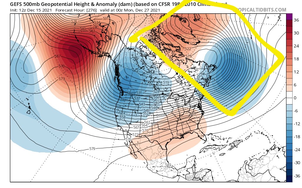
As a quick update, one of these is not like others…..


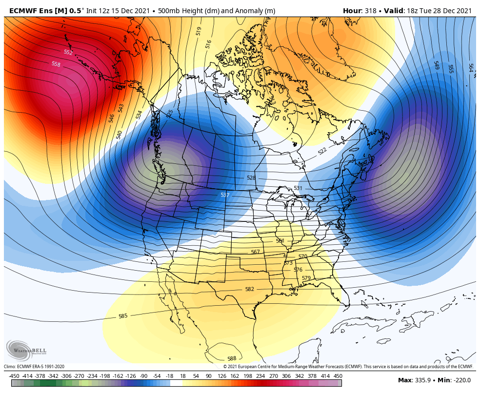
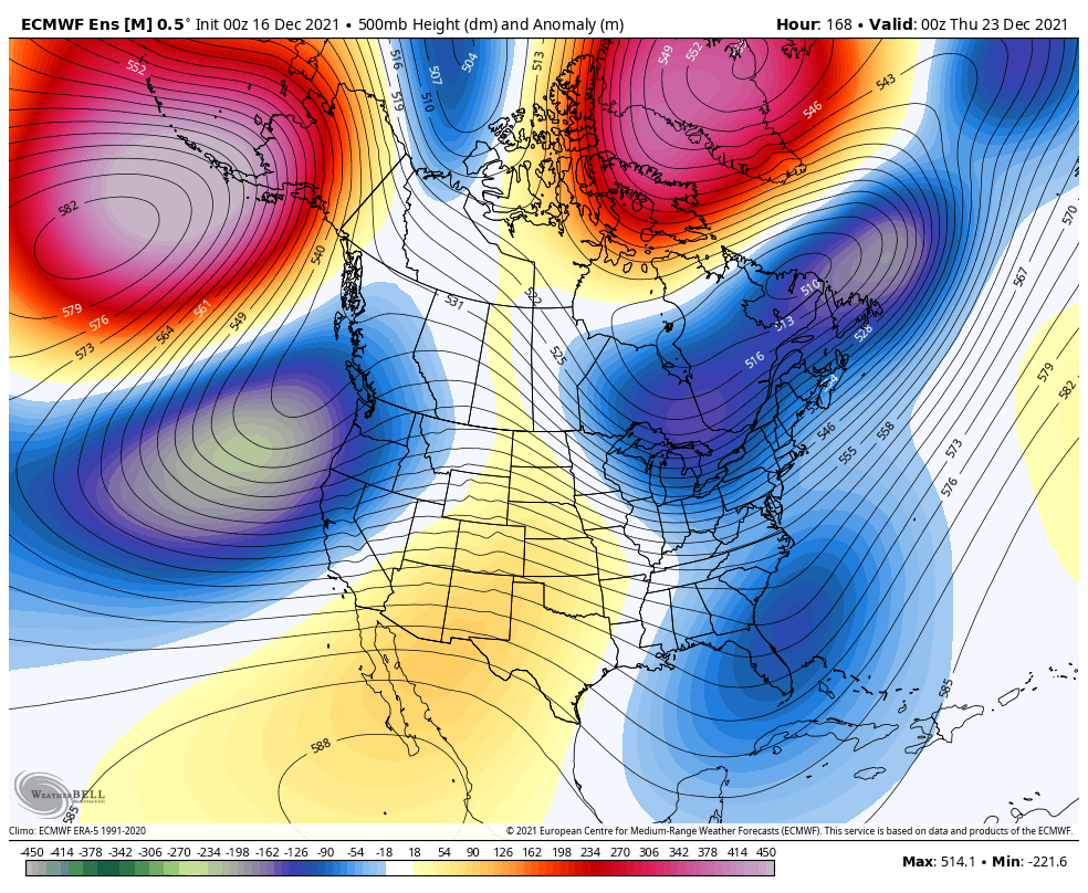
The green annotated cross is highlighting what’s known as Cahir’s Connection, or more generally, a 70N/70E ridge. This is a feature that I like to look for as an “anchoring” feature. Basically it’s a feature that works to orient the Northern Hemispheric pattern to enhance western North American ridging and eastern North American troughing. I mentioned this the other day when I saw the 18z GFS suite first hint at its development, and said that this is another domino in the evolution that I’m waiting to see start evolving after the New Year, but that we needed to see it continue to show up in the modeling to make sure that it’s not phantom. Well, as shown above, we now have it in all three major global ensembles. However, only the GEPS (GEM/CMC Ensemble) have a Northern Hemispheric alignment that makes physical sense in the presence of the 70N70/E ridge, as well as when earlier arguments and conceptions are considered. As such, I think both the GFS and Euro Ensembles are keeping the Aleutian ridge and western North American trough too far west/retracted in their depictions, and should correct toward the GDPS (GEM/CMC Ensemble) depiction in subsequent runs, with more ridging in western North America, and troughing in eastern North America. This would also fit the JMA progression posted earlier today in a tweet. Lets see how these models start behaving now, because this should get interesting.
rb924119- Meteorologist
- Posts : 6890
Reputation : 194
Join date : 2013-02-06
Age : 32
Location : Greentown, Pa
Re: Long Range Discussion 22.0
![]() by rb924119 Thu Dec 16, 2021 11:19 pm
by rb924119 Thu Dec 16, 2021 11:19 pm
rb924119- Meteorologist
- Posts : 6890
Reputation : 194
Join date : 2013-02-06
Age : 32
Location : Greentown, Pa
Re: Long Range Discussion 22.0
![]() by amugs Fri Dec 17, 2021 6:50 am
by amugs Fri Dec 17, 2021 6:50 am

_________________
Mugs
AKA:King: Snow Weenie
Self Proclaimed
WINTER 2014-15 : 55.12" +.02 for 6 coatings (avg. 35")
WINTER 2015-16 Total - 29.8" (Avg 35")
WINTER 2016-17 : 39.5" so far
amugs- Advanced Forecaster - Mod
- Posts : 15093
Reputation : 213
Join date : 2013-01-07
Age : 54
Location : Hillsdale,NJ
Page 12 of 31 • 1 ... 7 ... 11, 12, 13 ... 21 ... 31 ![]()
|
|
|