
 Search
Long Range Discussion 22.0
Page 3 of 31 •  1, 2, 3, 4 ... 17 ... 31
 ![]()
Re: Long Range Discussion 22.0
![]() by Frank_Wx Fri Oct 22, 2021 10:10 am
by Frank_Wx Fri Oct 22, 2021 10:10 am


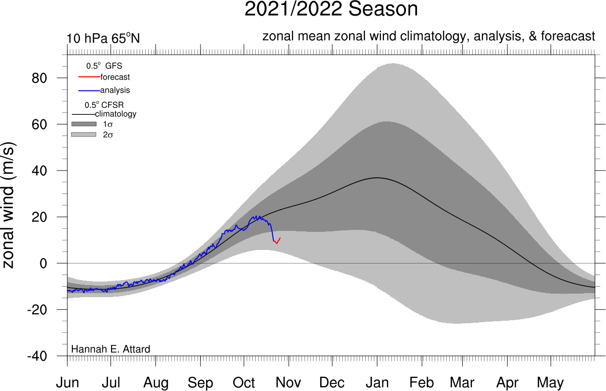
The EPS is a bit more bullish on flipping the heights across NPAC from negative to positive. With the MJO suppressed and Strat PV in a weakened state (see below) - conditions seem to favor a pretty cold start to November. How long that lasts and whether or not it leads to our first snow of the season remains to be seen.
Frank_Wx- Godzilla Seeker

- Posts : 21305
Join date : 2013-01-05 -

amugs likes this post
Re: Long Range Discussion 22.0
![]() by amugs Fri Oct 22, 2021 1:04 pm
by amugs Fri Oct 22, 2021 1:04 pm

amugs- Advanced Forecaster - Mod

- Posts : 15093
Join date : 2013-01-07
Re: Long Range Discussion 22.0
![]() by Frank_Wx Sat Oct 23, 2021 9:06 am
by Frank_Wx Sat Oct 23, 2021 9:06 am

_________________
_______________________________________________________________________________________________________
CLICK HERE to view NJ Strong Snowstorm Classifications

Frank_Wx- Godzilla Seeker
- Posts : 21305
Reputation : 328
Join date : 2013-01-05
Age : 31
Location : Jersey City, NJ -
Re: Long Range Discussion 22.0
![]() by amugs Mon Oct 25, 2021 8:16 am
by amugs Mon Oct 25, 2021 8:16 am

_________________
Mugs
AKA:King: Snow Weenie
Self Proclaimed
WINTER 2014-15 : 55.12" +.02 for 6 coatings (avg. 35")
WINTER 2015-16 Total - 29.8" (Avg 35")
WINTER 2016-17 : 39.5" so far

amugs- Advanced Forecaster - Mod
- Posts : 15093
Reputation : 213
Join date : 2013-01-07
Age : 54
Location : Hillsdale,NJ
Re: Long Range Discussion 22.0
![]() by Frank_Wx Tue Oct 26, 2021 3:04 pm
by Frank_Wx Tue Oct 26, 2021 3:04 pm

_________________
_______________________________________________________________________________________________________
CLICK HERE to view NJ Strong Snowstorm Classifications
Frank_Wx- Godzilla Seeker
- Posts : 21305
Reputation : 328
Join date : 2013-01-05
Age : 31
Location : Jersey City, NJ -
Re: Long Range Discussion 22.0
![]() by Frank_Wx Tue Oct 26, 2021 3:07 pm
by Frank_Wx Tue Oct 26, 2021 3:07 pm


_________________
_______________________________________________________________________________________________________
CLICK HERE to view NJ Strong Snowstorm Classifications
Frank_Wx- Godzilla Seeker
- Posts : 21305
Reputation : 328
Join date : 2013-01-05
Age : 31
Location : Jersey City, NJ -
Re: Long Range Discussion 22.0
![]() by Frank_Wx Tue Oct 26, 2021 3:11 pm
by Frank_Wx Tue Oct 26, 2021 3:11 pm
_________________
_______________________________________________________________________________________________________
CLICK HERE to view NJ Strong Snowstorm Classifications
Frank_Wx- Godzilla Seeker
- Posts : 21305
Reputation : 328
Join date : 2013-01-05
Age : 31
Location : Jersey City, NJ -
Re: Long Range Discussion 22.0
![]() by Frank_Wx Tue Oct 26, 2021 9:36 pm
by Frank_Wx Tue Oct 26, 2021 9:36 pm

_________________
_______________________________________________________________________________________________________
CLICK HERE to view NJ Strong Snowstorm Classifications
Frank_Wx- Godzilla Seeker
- Posts : 21305
Reputation : 328
Join date : 2013-01-05
Age : 31
Location : Jersey City, NJ -
Re: Long Range Discussion 22.0
![]() by amugs Wed Oct 27, 2021 9:56 am
by amugs Wed Oct 27, 2021 9:56 am

_________________
Mugs
AKA:King: Snow Weenie
Self Proclaimed
WINTER 2014-15 : 55.12" +.02 for 6 coatings (avg. 35")
WINTER 2015-16 Total - 29.8" (Avg 35")
WINTER 2016-17 : 39.5" so far
amugs- Advanced Forecaster - Mod
- Posts : 15093
Reputation : 213
Join date : 2013-01-07
Age : 54
Location : Hillsdale,NJ
Re: Long Range Discussion 22.0
![]() by amugs Wed Oct 27, 2021 9:57 am
by amugs Wed Oct 27, 2021 9:57 am
Today's U.S. subseasonal report was an interesting exercise: big model changes, plus a striking analog related to the weak stratospheric vortex. Subseasonal reports go out Tue and Fri a.m. as part of our trading markets application #powermarkets https://t.co/WEt2tbgABA pic.twitter.com/CeNxg5gCHu
— World Climate Service (@WorldClimateSvc) October 26, 2021
_________________
Mugs
AKA:King: Snow Weenie
Self Proclaimed
WINTER 2014-15 : 55.12" +.02 for 6 coatings (avg. 35")
WINTER 2015-16 Total - 29.8" (Avg 35")
WINTER 2016-17 : 39.5" so far
amugs- Advanced Forecaster - Mod
- Posts : 15093
Reputation : 213
Join date : 2013-01-07
Age : 54
Location : Hillsdale,NJ
Re: Long Range Discussion 22.0
![]() by Frank_Wx Wed Oct 27, 2021 11:26 am
by Frank_Wx Wed Oct 27, 2021 11:26 am
amugs wrote:Dr Cohen says colder weather ahead from these charts - Stratospheric warming in teh orangy colors coupled down to the Polar Vortex Arctic Region to help release the colder air
The warming in November is correlated directly back to the Wave 2 warming happening at the Trop
_________________
_______________________________________________________________________________________________________
CLICK HERE to view NJ Strong Snowstorm Classifications
Frank_Wx- Godzilla Seeker
- Posts : 21305
Reputation : 328
Join date : 2013-01-05
Age : 31
Location : Jersey City, NJ -
Re: Long Range Discussion 22.0
![]() by Frank_Wx Wed Oct 27, 2021 10:53 pm
by Frank_Wx Wed Oct 27, 2021 10:53 pm
_________________
_______________________________________________________________________________________________________
CLICK HERE to view NJ Strong Snowstorm Classifications
Frank_Wx- Godzilla Seeker
- Posts : 21305
Reputation : 328
Join date : 2013-01-05
Age : 31
Location : Jersey City, NJ -
kalleg likes this post
Re: Long Range Discussion 22.0
![]() by amugs Thu Oct 28, 2021 12:22 pm
by amugs Thu Oct 28, 2021 12:22 pm
_________________
Mugs
AKA:King: Snow Weenie
Self Proclaimed
WINTER 2014-15 : 55.12" +.02 for 6 coatings (avg. 35")
WINTER 2015-16 Total - 29.8" (Avg 35")
WINTER 2016-17 : 39.5" so far
amugs- Advanced Forecaster - Mod
- Posts : 15093
Reputation : 213
Join date : 2013-01-07
Age : 54
Location : Hillsdale,NJ
Re: Long Range Discussion 22.0
![]() by amugs Fri Oct 29, 2021 1:14 pm
by amugs Fri Oct 29, 2021 1:14 pm
And it is showing this
_________________
Mugs
AKA:King: Snow Weenie
Self Proclaimed
WINTER 2014-15 : 55.12" +.02 for 6 coatings (avg. 35")
WINTER 2015-16 Total - 29.8" (Avg 35")
WINTER 2016-17 : 39.5" so far
amugs- Advanced Forecaster - Mod
- Posts : 15093
Reputation : 213
Join date : 2013-01-07
Age : 54
Location : Hillsdale,NJ
Re: Long Range Discussion 22.0
![]() by amugs Fri Oct 29, 2021 8:51 pm
by amugs Fri Oct 29, 2021 8:51 pm

_________________
Mugs
AKA:King: Snow Weenie
Self Proclaimed
WINTER 2014-15 : 55.12" +.02 for 6 coatings (avg. 35")
WINTER 2015-16 Total - 29.8" (Avg 35")
WINTER 2016-17 : 39.5" so far
amugs- Advanced Forecaster - Mod
- Posts : 15093
Reputation : 213
Join date : 2013-01-07
Age : 54
Location : Hillsdale,NJ
Re: Long Range Discussion 22.0
![]() by amugs Sat Oct 30, 2021 4:40 pm
by amugs Sat Oct 30, 2021 4:40 pm
Boy the GEFS is just going bonkers for November into December. Western ridge, Alaskan ridge, blocked up arctic.
— Joey Scherkenbach (@jscherkenbach1) October 29, 2021
This is NOT a forecast, but all signs point towards a front loaded winter pic.twitter.com/3RrYT6IEPO
_________________
Mugs
AKA:King: Snow Weenie
Self Proclaimed
WINTER 2014-15 : 55.12" +.02 for 6 coatings (avg. 35")
WINTER 2015-16 Total - 29.8" (Avg 35")
WINTER 2016-17 : 39.5" so far
amugs- Advanced Forecaster - Mod
- Posts : 15093
Reputation : 213
Join date : 2013-01-07
Age : 54
Location : Hillsdale,NJ
Re: Long Range Discussion 22.0
![]() by sroc4 Sat Oct 30, 2021 5:29 pm
by sroc4 Sat Oct 30, 2021 5:29 pm

_________________
"In weather and in life, there's no winning and losing; there's only winning and learning."
WINTER 2012/2013 TOTALS 43.65"WINTER 2017/2018 TOTALS 62.85" WINTER 2022/2023 TOTALS 4.9"
WINTER 2013/2014 TOTALS 64.85"WINTER 2018/2019 TOTALS 14.25" WINTER 2023/2024 TOTALS 13.1"
WINTER 2014/2015 TOTALS 71.20"WINTER 2019/2020 TOTALS 6.35"
WINTER 2015/2016 TOTALS 35.00"WINTER 2020/2021 TOTALS 37.75"
WINTER 2016/2017 TOTALS 42.25"WINTER 2021/2022 TOTALS 31.65"

sroc4- Admin
- Posts : 8331
Reputation : 301
Join date : 2013-01-07
Location : Wading River, LI
brownie, weatherwatchermom and SENJsnowman like this post
Re: Long Range Discussion 22.0
![]() by sroc4 Sat Oct 30, 2021 7:30 pm
by sroc4 Sat Oct 30, 2021 7:30 pm
_________________
"In weather and in life, there's no winning and losing; there's only winning and learning."
WINTER 2012/2013 TOTALS 43.65"WINTER 2017/2018 TOTALS 62.85" WINTER 2022/2023 TOTALS 4.9"
WINTER 2013/2014 TOTALS 64.85"WINTER 2018/2019 TOTALS 14.25" WINTER 2023/2024 TOTALS 13.1"
WINTER 2014/2015 TOTALS 71.20"WINTER 2019/2020 TOTALS 6.35"
WINTER 2015/2016 TOTALS 35.00"WINTER 2020/2021 TOTALS 37.75"
WINTER 2016/2017 TOTALS 42.25"WINTER 2021/2022 TOTALS 31.65"
sroc4- Admin
- Posts : 8331
Reputation : 301
Join date : 2013-01-07
Location : Wading River, LI
Re: Long Range Discussion 22.0
![]() by amugs Sun Oct 31, 2021 4:27 pm
by amugs Sun Oct 31, 2021 4:27 pm
_________________
Mugs
AKA:King: Snow Weenie
Self Proclaimed
WINTER 2014-15 : 55.12" +.02 for 6 coatings (avg. 35")
WINTER 2015-16 Total - 29.8" (Avg 35")
WINTER 2016-17 : 39.5" so far
amugs- Advanced Forecaster - Mod
- Posts : 15093
Reputation : 213
Join date : 2013-01-07
Age : 54
Location : Hillsdale,NJ
sroc4 likes this post
Re: Long Range Discussion 22.0
![]() by sroc4 Mon Nov 01, 2021 7:58 am
by sroc4 Mon Nov 01, 2021 7:58 am
sroc4 wrote:Good morning everyone. Its about this time that we begin to look at the Siberian/Eurasian snow cover. Between about now through the end of Oct/November, the snow growth rate and persistent snow cover in this area has been shown to have a relationship in determining the state of the Arctic Oscillation(AO) during the winter months. The more rapid the snow growth rate and the expansiveness of the snow cover over Siberia/northern Eurasia during this time frame, the stronger the correlation with a negative AO during winter months seems to be. As far as my understanding, the idea behind this is that a rapid expanse of snow cover over this extremely large region acts as a giant mirror if you will. A white blanket of snow acts to reflect a large amount of sunlight back up into the atmosphere over the arctic. On a smaller scale this reflective light is why its easy to get a sun burn on the ski slopes on a sunny day in the dead of winter. This reflected sunlight back up into the atmosphere on such a large scale can influence the temperature and pressure patterns over the Arctic regions at various levels of the atmosphere. A negative AO means the tendency is to form "blocking" domes of high pressure in the northern latitudes, particularly over the arctic circle, which tends to favor the discharge of cold arctic air masses into the southern latitudes.
Keep in mind Siberian/Eurasian snow cover during the fall is only one piece to the complex puzzle that comes together to determine the winter pattern over the short and longer term. In addition the exact relationship of the snow cover and the AO state is still not fully understood. Other oscillations(QBO, NAO, EPO, PNA to name a few), large scale sea surface temp patterns, and stratospheric temps, etc all come together to determine the final outcome of the pattern. Within any given year these varying factors all may play larger or smaller roles in determining the outcome.
Anyway here is the current snow cover anomalies for the northern hemisphere with purple colors above normal snow fall for this time of year, red below and white normal.


Here is a quick update on the past 5-6 weeks for Siberian snow growth. See above for its relevance. Images bove are Sept 20th, Oct 12th, and Oct 31st. Overall North American snow growth has been pretty abysmal while Siberian snow growth has been about normal with southern portions of the Eurasian continent below normal. Overall Im not sure how much real influence this aspect will have over the Strat and AO this year.
A little more disconcerting is the MJO. about 7-10days ago or so it was forecast to move out of the Null phase; into phases 8, 1, 2, which tend to favor troughyness and normal to below normal temps into the Eastern third of the country; however, that no longer appears to be the case. Instead it appears it has put on the breaks, and will instead remerge with an MJO pulse back out into the warmer phases of 4, 5, and 6. It isn't uncommon to see the MJO recycle itself in similar phases unless other big picture influences can cause a shift. As you can see below late sept through Mid Oct the MJO pulse traversed through phases 4-6 before returning into the center where it has been for the past two weeks or so.


Regarding phases 4, 5, and 6:
MJO Temp composites for Oct/Nov/Dec (OND) compared to the Nov/Dec/Jan(NDJ) does differ with the former still having a tendency for troughs into the SE and our area being on the boundary for abve vs below normal temps. Compared to NDJ These phases are an all out torch for our area.


The next week or two should feel nice but concern is beyond that that the temps "MAY" go back to above normal on avg. The strat is your wild card as is always.
_________________
"In weather and in life, there's no winning and losing; there's only winning and learning."
WINTER 2012/2013 TOTALS 43.65"WINTER 2017/2018 TOTALS 62.85" WINTER 2022/2023 TOTALS 4.9"
WINTER 2013/2014 TOTALS 64.85"WINTER 2018/2019 TOTALS 14.25" WINTER 2023/2024 TOTALS 13.1"
WINTER 2014/2015 TOTALS 71.20"WINTER 2019/2020 TOTALS 6.35"
WINTER 2015/2016 TOTALS 35.00"WINTER 2020/2021 TOTALS 37.75"
WINTER 2016/2017 TOTALS 42.25"WINTER 2021/2022 TOTALS 31.65"
sroc4- Admin
- Posts : 8331
Reputation : 301
Join date : 2013-01-07
Location : Wading River, LI
Re: Long Range Discussion 22.0
![]() by Frank_Wx Mon Nov 01, 2021 11:36 am
by Frank_Wx Mon Nov 01, 2021 11:36 am

Some pretty ugly signs lately...
_________________
_______________________________________________________________________________________________________
CLICK HERE to view NJ Strong Snowstorm Classifications
Frank_Wx- Godzilla Seeker
- Posts : 21305
Reputation : 328
Join date : 2013-01-05
Age : 31
Location : Jersey City, NJ -
Re: Long Range Discussion 22.0
![]() by Frank_Wx Mon Nov 01, 2021 11:47 am
by Frank_Wx Mon Nov 01, 2021 11:47 am
Frank_Wx wrote:Pattern in the first 7 days of November is setting up for the first significant snow of the season central to upstate NY. There’s a chance those N&W of NYC in our region see their first snow as well. I’m not yet confident in anything for the coast but obviously very early for that to change. Regardless, the pressure put on the SPV only means good things down the line for us. Just don’t want to see La Niña takeover completely
Update since my last post:
*AO still on track to go negative
*Our area will experience colder than normal temps over next 3-7 days because of AO (see map below)
*No real significant snow forecasted in NE region despite the cold air
*For the most part, our area will return to seasonal or slightly above seasonal temps after this mini cold outbreak because we're not seeing cooperation on the Pacific side - likely due to emerging Nina/MJO
*GEFS shows return to colder than normal weather as -NAO tries to develop

_________________
_______________________________________________________________________________________________________
CLICK HERE to view NJ Strong Snowstorm Classifications
Frank_Wx- Godzilla Seeker
- Posts : 21305
Reputation : 328
Join date : 2013-01-05
Age : 31
Location : Jersey City, NJ -
Re: Long Range Discussion 22.0
![]() by sroc4 Tue Nov 02, 2021 6:10 am
by sroc4 Tue Nov 02, 2021 6:10 am
Now make sure we keep expectations in check as this is 15days out, and as I pointed out above, if the MJO forecasts come to fruition there will be resistance in the atmosphere. It will be interesting to see how it evolves. Ill try and post updated snap shots of the evolution as we go along.


_________________
"In weather and in life, there's no winning and losing; there's only winning and learning."
WINTER 2012/2013 TOTALS 43.65"WINTER 2017/2018 TOTALS 62.85" WINTER 2022/2023 TOTALS 4.9"
WINTER 2013/2014 TOTALS 64.85"WINTER 2018/2019 TOTALS 14.25" WINTER 2023/2024 TOTALS 13.1"
WINTER 2014/2015 TOTALS 71.20"WINTER 2019/2020 TOTALS 6.35"
WINTER 2015/2016 TOTALS 35.00"WINTER 2020/2021 TOTALS 37.75"
WINTER 2016/2017 TOTALS 42.25"WINTER 2021/2022 TOTALS 31.65"
sroc4- Admin
- Posts : 8331
Reputation : 301
Join date : 2013-01-07
Location : Wading River, LI
kalleg likes this post
Re: Long Range Discussion 22.0
![]() by amugs Wed Nov 03, 2021 9:17 pm
by amugs Wed Nov 03, 2021 9:17 pm
Latest QBO plot & E'ly phase continues above 40hPa, weak W'lies below - Of importance: We have the rare combo of a La Nina & eQBO moving into winter, which has been highlighted for some time. I, therefore, suggest a SSW is a higher risk this winter, between mid-Dec to mid-Jan... pic.twitter.com/EdTPxcQrXi
— Matt Hugo (@MattHugo81) November 3, 2021

Hugo is very good at QBO and SSW events like last year. Intriguing
_________________
Mugs
AKA:King: Snow Weenie
Self Proclaimed
WINTER 2014-15 : 55.12" +.02 for 6 coatings (avg. 35")
WINTER 2015-16 Total - 29.8" (Avg 35")
WINTER 2016-17 : 39.5" so far
amugs- Advanced Forecaster - Mod
- Posts : 15093
Reputation : 213
Join date : 2013-01-07
Age : 54
Location : Hillsdale,NJ
Re: Long Range Discussion 22.0
![]() by amugs Wed Nov 03, 2021 10:32 pm
by amugs Wed Nov 03, 2021 10:32 pm
Looking at the pattern ahead, chilly to end this week, rather mild next week, then perhaps a legitimate pattern flip the following week. Strong signs of a +PNA/-EPO couplet, which pumps western ridging/eastern troughing. This *could have staying power, too far to know for sure. pic.twitter.com/DX7qF0Ns9T
— Joey Scherkenbach (@jscherkenbach1) November 3, 2021
_________________
Mugs
AKA:King: Snow Weenie
Self Proclaimed
WINTER 2014-15 : 55.12" +.02 for 6 coatings (avg. 35")
WINTER 2015-16 Total - 29.8" (Avg 35")
WINTER 2016-17 : 39.5" so far
amugs- Advanced Forecaster - Mod
- Posts : 15093
Reputation : 213
Join date : 2013-01-07
Age : 54
Location : Hillsdale,NJ
Re: Long Range Discussion 22.0
![]() by amugs Thu Nov 04, 2021 10:10 am
by amugs Thu Nov 04, 2021 10:10 am

_________________
Mugs
AKA:King: Snow Weenie
Self Proclaimed
WINTER 2014-15 : 55.12" +.02 for 6 coatings (avg. 35")
WINTER 2015-16 Total - 29.8" (Avg 35")
WINTER 2016-17 : 39.5" so far
amugs- Advanced Forecaster - Mod
- Posts : 15093
Reputation : 213
Join date : 2013-01-07
Age : 54
Location : Hillsdale,NJ
Re: Long Range Discussion 22.0
![]() by amugs Thu Nov 04, 2021 10:05 pm
by amugs Thu Nov 04, 2021 10:05 pm
Updated run of the ECMWF weeklies are complete.
— Ethan Sacoransky (@blizzardof96) November 4, 2021
They strongly indicate that weeks 3 & 4 of November will kickoff winter across the Eastern US and Canada. Classic signal for significant cold and snow potential. pic.twitter.com/wlrvhuPNOs
What's the significance of this event? The east-asian cutoff low allows the north pacific jet to amplify in a wavelike/stepwise pattern. Notice how this eventually results in a great lakes trough ~Nov 13th. pic.twitter.com/dkr7YeAuFT
— Ethan Sacoransky (@blizzardof96) November 5, 2021
_________________
Mugs
AKA:King: Snow Weenie
Self Proclaimed
WINTER 2014-15 : 55.12" +.02 for 6 coatings (avg. 35")
WINTER 2015-16 Total - 29.8" (Avg 35")
WINTER 2016-17 : 39.5" so far
amugs- Advanced Forecaster - Mod
- Posts : 15093
Reputation : 213
Join date : 2013-01-07
Age : 54
Location : Hillsdale,NJ
Page 3 of 31 • 1, 2, 3, 4 ... 17 ... 31 ![]()
|
|
|