December 2021 Obs and Discussion
Page 1 of 7 • 1, 2, 3, 4, 5, 6, 7 
 December 2021 Obs and Discussion
_________________
Janet
Snowfall winter of 2023-2024 17.5"
Snowfall winter of 2022-2023 6.0"
Snowfall winter of 2021-2022 17.6" 1" sleet 2/25/22
Snowfall winter of 2020-2021 51.1"
Snowfall winter of 2019-2020 8.5"
Snowfall winter of 2018-2019 25.1"
Snowfall winter of 2017-2018 51.9"
Snowfall winter of 2016-2017 45.6"
Snowfall winter of 2015-2016 29.5"
Snowfall winter of 2014-2015 50.55"
Snowfall winter of 2013-2014 66.5"
Dunnzoo- Senior Enthusiast - Mod

- Posts : 4905
Reputation : 68
Join date : 2013-01-11
Age : 62
Location : Westwood, NJ
Frank_Wx, sroc4, amugs, rb924119, weatherwatchermom and SENJsnowman like this post
 Re: December 2021 Obs and Discussion
Math23x7- Wx Statistician Guru

- Posts : 2379
Reputation : 68
Join date : 2013-01-08
 Re: December 2021 Obs and Discussion
_________________
Janet
Snowfall winter of 2023-2024 17.5"
Snowfall winter of 2022-2023 6.0"
Snowfall winter of 2021-2022 17.6" 1" sleet 2/25/22
Snowfall winter of 2020-2021 51.1"
Snowfall winter of 2019-2020 8.5"
Snowfall winter of 2018-2019 25.1"
Snowfall winter of 2017-2018 51.9"
Snowfall winter of 2016-2017 45.6"
Snowfall winter of 2015-2016 29.5"
Snowfall winter of 2014-2015 50.55"
Snowfall winter of 2013-2014 66.5"

Dunnzoo- Senior Enthusiast - Mod

- Posts : 4905
Reputation : 68
Join date : 2013-01-11
Age : 62
Location : Westwood, NJ
SENJsnowman likes this post
 Re: December 2021 Obs and Discussion
Dunnzoo wrote:Thankful for a mild day today, going to decorate the outside of the house!
It looks like 10-14 day forecast is going to be quite mild indeed. I see a 61* high temp looming for next week imby, might even get there today! The avg high at GSP Exit 80 for the next 2 weeks is about 50-52*. The avg low looks to be 38-40. So, i figure to have plenty of opportunity to pursue my other other outdoor passion- yep, smoking meats!!!!
I absolutely loved both the conclusions and the tone of rbs latest posts. For both the long and short range, Ray is just gifted at sniffing out the snowstorm killing factors and conditions when they are present. So, if he ain't sniffing any out, and in fact LIKES what he sees super long range- then I gotta give a little WOOT WOOT! as I bide my time.
Last thought that some of you can relate to- I'm going to visit the fam in Florida in the late December. The idea of missing a big snowstorm like that- esp with how hard the big one's are to score down here, I just can't imagine.
(Ray, sorry for talking about you like you aren't here lol)
Last edited by SENJsnowman on Thu Dec 02, 2021 9:24 am; edited 1 time in total
SENJsnowman- Senior Enthusiast

- Posts : 1189
Reputation : 61
Join date : 2017-01-06
Age : 51
Location : Bayville, NJ
rb924119 and weatherwatchermom like this post
 Re: December 2021 Obs and Discussion
heehaw453- Advanced Forecaster

- Posts : 3906
Reputation : 86
Join date : 2014-01-20
Location : Bedminster Township, PA Elevation 600' ASL
rb924119 and weatherwatchermom like this post
 Re: December 2021 Obs and Discussion
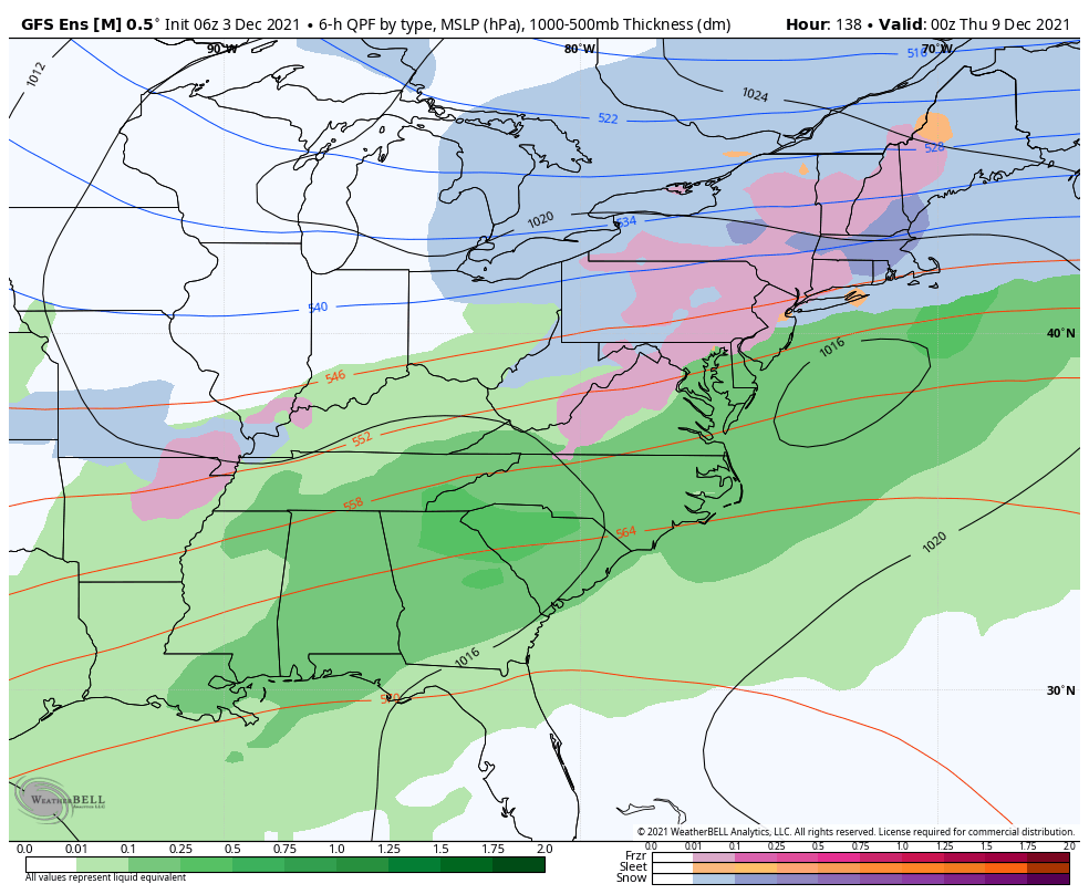
I would think no snow accumulation for coastal plain and there is a potential for at least a few inches north of rt 80 away from the coast. That is the area I think that could be interesting on this one.
heehaw453- Advanced Forecaster

- Posts : 3906
Reputation : 86
Join date : 2014-01-20
Location : Bedminster Township, PA Elevation 600' ASL
 Re: December 2021 Obs and Discussion
PS - the calls for blowtorch that some are making especially on line in the cease pools of SM need to quell their hype if you read some of these as models have kicked the can a bit - I do expect AN after this pattern goes to wayward but not to the degree some are portraying. Canada and the Arctic will be building a glacier bodes well down the road IMO. Also, Ural/Scandinavian HP and MJO phase 6 heat flux will aid in EAMT (East Asian Mountain Torque) engendering a knock around of the PV and displacement of the cold air baring any other developments.
_________________
Mugs
AKA:King: Snow Weenie
Self Proclaimed
WINTER 2014-15 : 55.12" +.02 for 6 coatings (avg. 35")
WINTER 2015-16 Total - 29.8" (Avg 35")
WINTER 2016-17 : 39.5" so far

amugs- Advanced Forecaster - Mod

- Posts : 15095
Reputation : 213
Join date : 2013-01-07
Age : 54
Location : Hillsdale,NJ
 Re: December 2021 Obs and Discussion
_________________
Mugs
AKA:King: Snow Weenie
Self Proclaimed
WINTER 2014-15 : 55.12" +.02 for 6 coatings (avg. 35")
WINTER 2015-16 Total - 29.8" (Avg 35")
WINTER 2016-17 : 39.5" so far

amugs- Advanced Forecaster - Mod

- Posts : 15095
Reputation : 213
Join date : 2013-01-07
Age : 54
Location : Hillsdale,NJ
 Re: December 2021 Obs and Discussion
_________________
"In weather and in life, there's no winning and losing; there's only winning and learning."
WINTER 2012/2013 TOTALS 43.65"WINTER 2017/2018 TOTALS 62.85" WINTER 2022/2023 TOTALS 4.9"
WINTER 2013/2014 TOTALS 64.85"WINTER 2018/2019 TOTALS 14.25" WINTER 2023/2024 TOTALS 13.1"
WINTER 2014/2015 TOTALS 71.20"WINTER 2019/2020 TOTALS 6.35"
WINTER 2015/2016 TOTALS 35.00"WINTER 2020/2021 TOTALS 37.75"
WINTER 2016/2017 TOTALS 42.25"WINTER 2021/2022 TOTALS 31.65"

sroc4- Admin

- Posts : 8354
Reputation : 302
Join date : 2013-01-07
Location : Wading River, LI
 Re: December 2021 Obs and Discussion
sroc4 wrote:Take look at the CMC...woof!
Let me be clear here. I DONT think this is how this plays out, BUT if we wanted to see the coast plain have any chance this is about the only way it happen in this pattern. Timing is everything. In order to see how tuesaday to wed plays out one of many key factors will be the system and frontal bondary that swings through late Monday into early Tuesday.
Where the boundary is, and how far north and west the system that brings the front through will play an integral part in where the HP to the north sets up that will try and hold the cold. Again the pattern as a whole does not lean in our favor, both Pac and Atlantic side but if you have been doing this long enough you know it can def snow is shitty patterns when the timing is just right.
Carry on
We TRACK!!

_________________
"In weather and in life, there's no winning and losing; there's only winning and learning."
WINTER 2012/2013 TOTALS 43.65"WINTER 2017/2018 TOTALS 62.85" WINTER 2022/2023 TOTALS 4.9"
WINTER 2013/2014 TOTALS 64.85"WINTER 2018/2019 TOTALS 14.25" WINTER 2023/2024 TOTALS 13.1"
WINTER 2014/2015 TOTALS 71.20"WINTER 2019/2020 TOTALS 6.35"
WINTER 2015/2016 TOTALS 35.00"WINTER 2020/2021 TOTALS 37.75"
WINTER 2016/2017 TOTALS 42.25"WINTER 2021/2022 TOTALS 31.65"

sroc4- Admin

- Posts : 8354
Reputation : 302
Join date : 2013-01-07
Location : Wading River, LI
amugs likes this post
 Re: December 2021 Obs and Discussion
heehaw453- Advanced Forecaster

- Posts : 3906
Reputation : 86
Join date : 2014-01-20
Location : Bedminster Township, PA Elevation 600' ASL
 Re: December 2021 Obs and Discussion
Another issue i'm seeing with the GFS especially, the surface Low is developing a bit too quick eastward IMO based off 500mb... the upper level energy profiles suggest the low should be developing a bit further south, it's common to see surface maps too eager with convection pic.twitter.com/46Jm9EFxAS
— NsfwWx(@NsfwWx) December 3, 2021
_________________
Mugs
AKA:King: Snow Weenie
Self Proclaimed
WINTER 2014-15 : 55.12" +.02 for 6 coatings (avg. 35")
WINTER 2015-16 Total - 29.8" (Avg 35")
WINTER 2016-17 : 39.5" so far

amugs- Advanced Forecaster - Mod

- Posts : 15095
Reputation : 213
Join date : 2013-01-07
Age : 54
Location : Hillsdale,NJ
 Re: December 2021 Obs and Discussion
amugs wrote:Another issue i'm seeing with the GFS especially, the surface Low is developing a bit too quick eastward IMO based off 500mb... the upper level energy profiles suggest the low should be developing a bit further south, it's common to see surface maps too eager with convection pic.twitter.com/46Jm9EFxAS
— NsfwWx(@NsfwWx) December 3, 2021
I disagree with what he says here Mugs. If you expand out to the NA view you can clearly see where the HP is placed. IMHO the placement of the HP AND strength of the lobe extending into the Atlantic on the GFS and weaker western flank vs CMC and how much stronger the HP is on the western flank on the CMC and centered further west compared to GFS is the difference and what allows the western track on the GFS compared to the weaker more southern and eastern soln on the CMC. Look at the GFS surface map he posted compared to the CMC. Path of least resistance. Based on where the wake and confluence of the Monday eve system are near greenland is positioned, the HP to our N on the surface map is right where it should be on the GFS and CMC respectively.
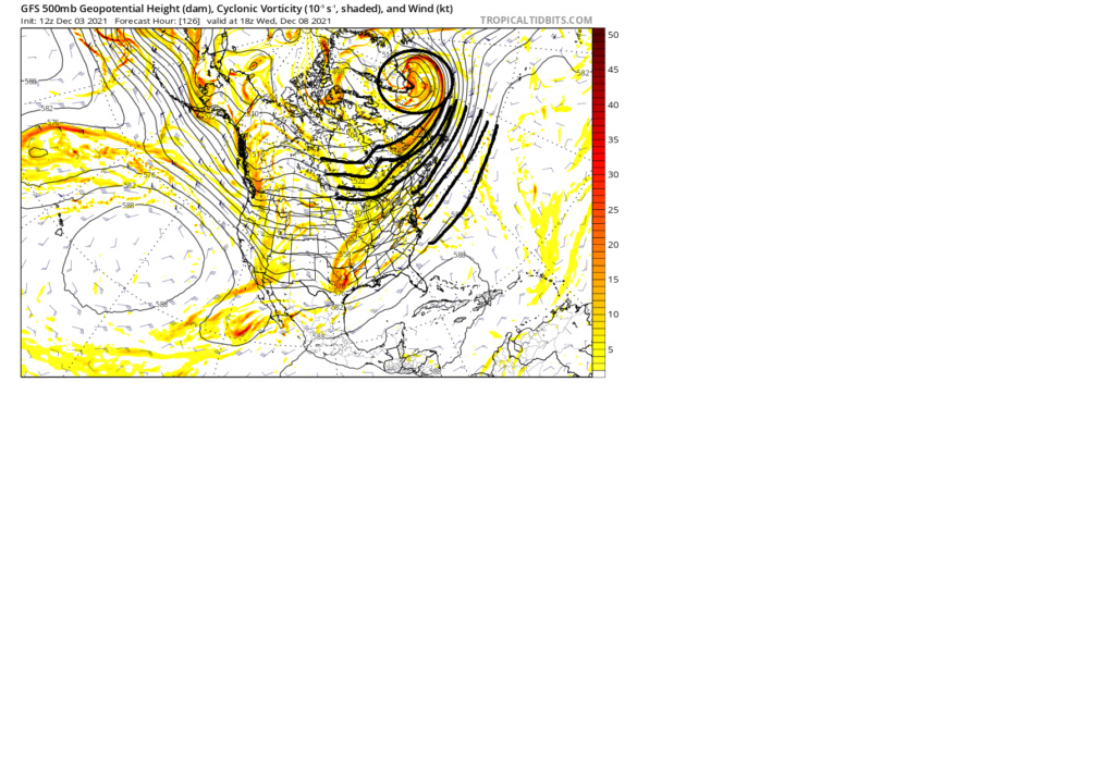

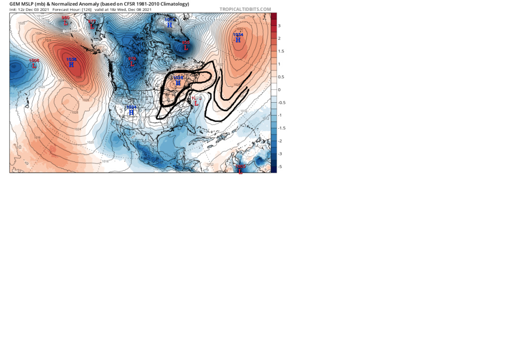


_________________
"In weather and in life, there's no winning and losing; there's only winning and learning."
WINTER 2012/2013 TOTALS 43.65"WINTER 2017/2018 TOTALS 62.85" WINTER 2022/2023 TOTALS 4.9"
WINTER 2013/2014 TOTALS 64.85"WINTER 2018/2019 TOTALS 14.25" WINTER 2023/2024 TOTALS 13.1"
WINTER 2014/2015 TOTALS 71.20"WINTER 2019/2020 TOTALS 6.35"
WINTER 2015/2016 TOTALS 35.00"WINTER 2020/2021 TOTALS 37.75"
WINTER 2016/2017 TOTALS 42.25"WINTER 2021/2022 TOTALS 31.65"

sroc4- Admin

- Posts : 8354
Reputation : 302
Join date : 2013-01-07
Location : Wading River, LI
amugs likes this post
 Re: December 2021 Obs and Discussion
heehaw453- Advanced Forecaster

- Posts : 3906
Reputation : 86
Join date : 2014-01-20
Location : Bedminster Township, PA Elevation 600' ASL
weatherwatchermom likes this post
 Re: December 2021 Obs and Discussion
heehaw453 wrote:Many op models showing a fairly stationary 1030mb+ High parked over Southern Quebec. I don't think this is going to be suppressed and OTS with a decent WAR. That gives the coastal plain a chance at some snow if that high pressure is correct. The antecedent air mass is good for early December on this and I can tell you that high pressure CAD is often under modelled. It will depend on how far away from the coast the storm consolidates. Once again though NW of 95 are in a threat for several inches of snow especially I-80 and above.
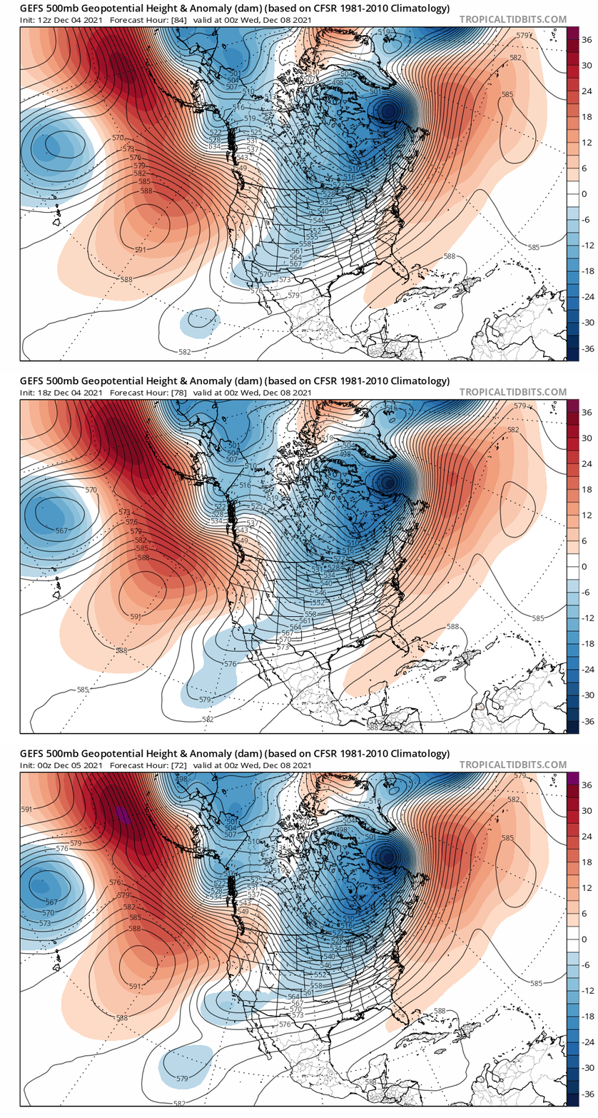
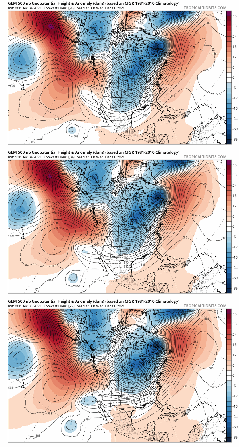
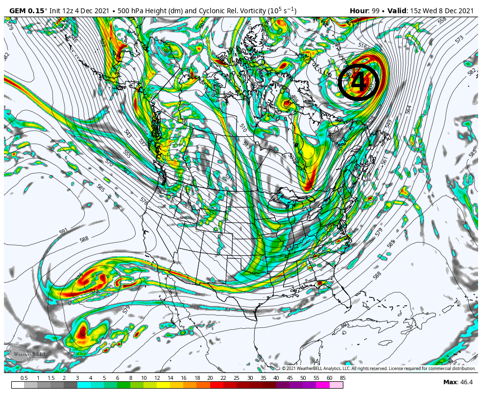
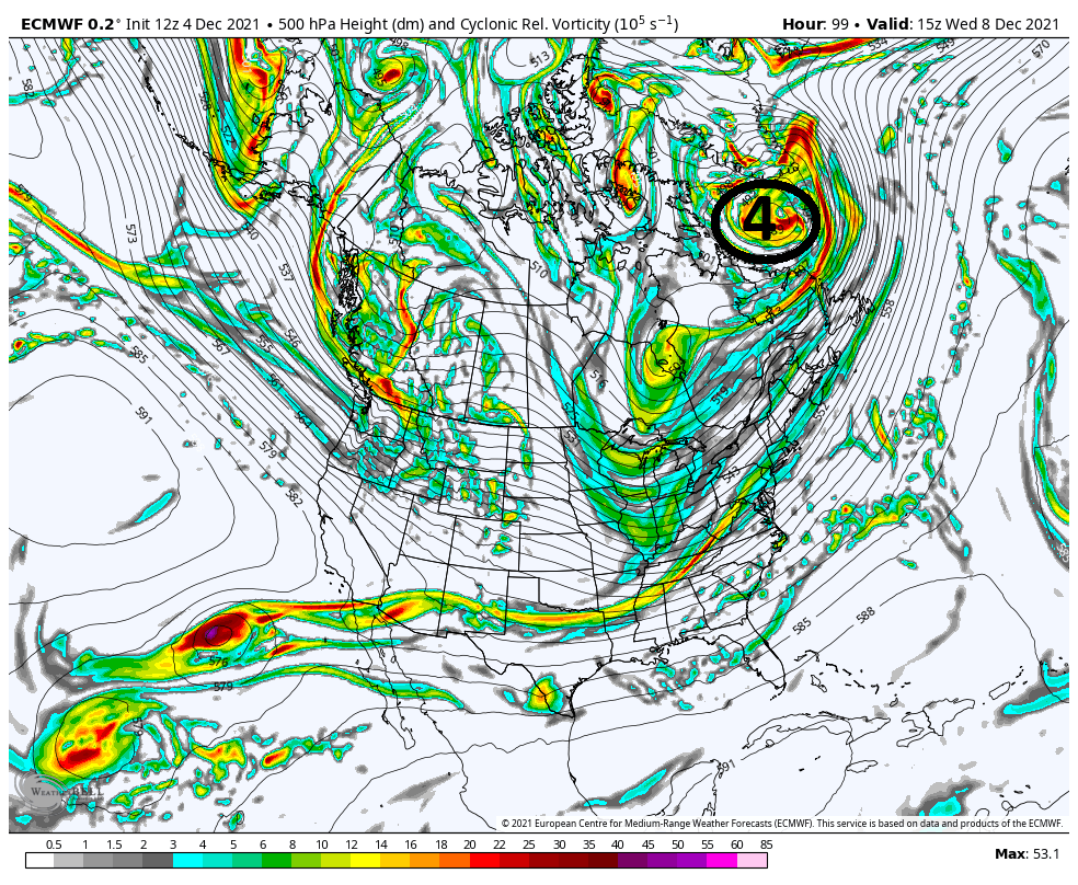
Looking at 500 you can see why that makes sense and why the GFS still has the HP retreating quickly, and is warmest soln, the Euro is the most suppressed and coldest soln, and the CMC is in between.
Here are the three global models at 500mb on approach and their respective surface depiction for the same time stamp. All valid for 15z Wed, or 10am Wed. Euro, CMC, and GFS.
The set up is such that a boundary layer will set up after the Late Mond system passes NW and drags the front through. Along the frontal boundary weak LP will develop, black circle #1, and ride along it. On the GFS you can see the result of #3 so far east and # 2 so far S&W relative to one another and the fact that #1 is out in front of #2 allows the boundary layer to set up furthest N of all solns.
The euro on the other hand is the other side of the soln cone where the proximity of both #3 to #2, forces the boundary much further S&E.
The positioning of #1, #2, an #3 relative to each other is in between the GFS an Euro.
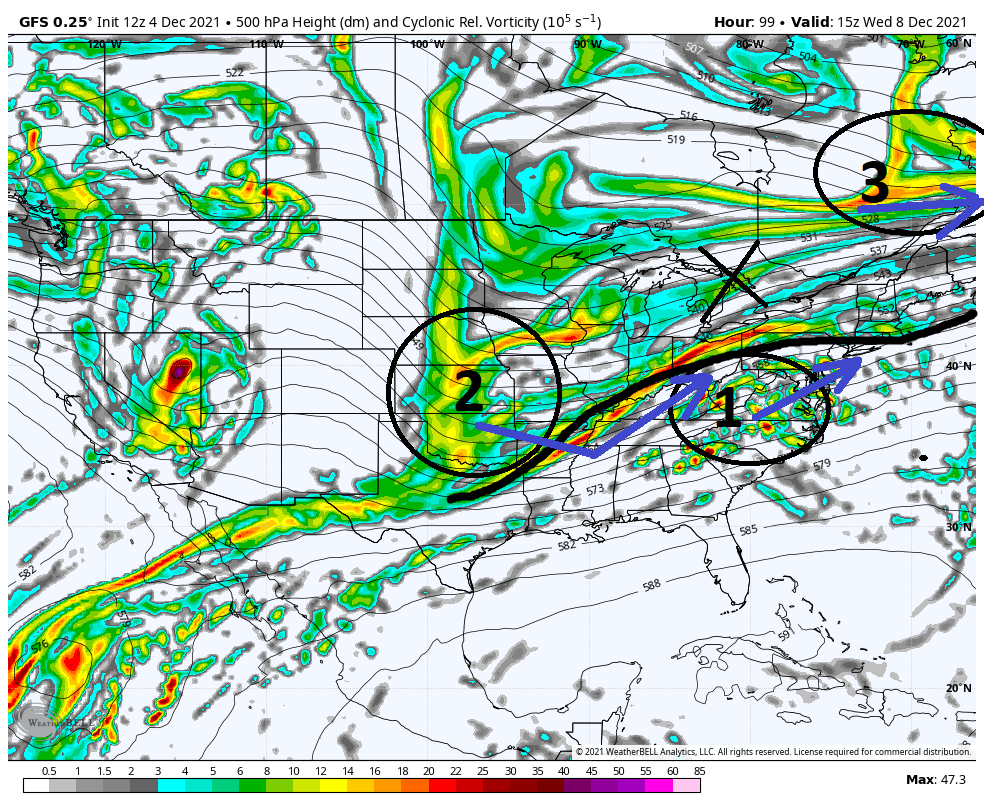
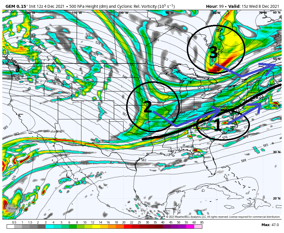
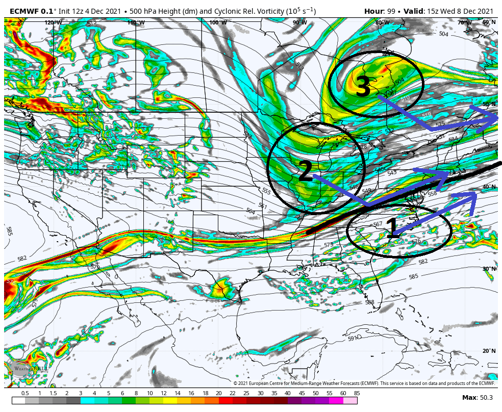

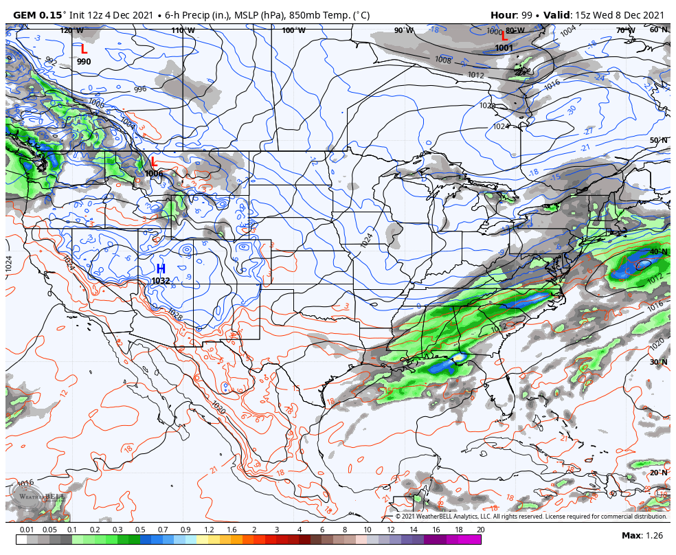
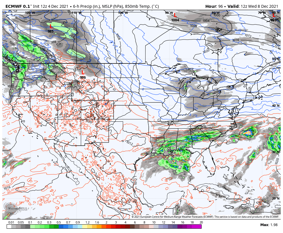
So if you look at the GFS as the current warmest soln, and the Euro as the coldest soln, very very commonly the final soln lies somewhere in between which def bodes well for most of us to see some white gold at least, and areas N&W in line for accumulation.
Just briefly below I expanded the 500mb view to see the location of where the system that passes Mondayends up. Again, GFS furthest N which allows our HP to escape faster, hence the warmer soln. Euro is the furthest S, and CMC in between.
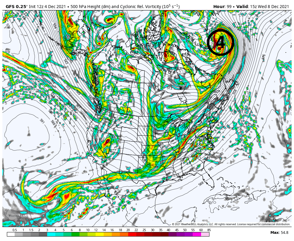
Im getting a little excited.
WE TRACK!!!!

Last edited by sroc4 on Sat Dec 04, 2021 2:24 pm; edited 1 time in total
_________________
"In weather and in life, there's no winning and losing; there's only winning and learning."
WINTER 2012/2013 TOTALS 43.65"WINTER 2017/2018 TOTALS 62.85" WINTER 2022/2023 TOTALS 4.9"
WINTER 2013/2014 TOTALS 64.85"WINTER 2018/2019 TOTALS 14.25" WINTER 2023/2024 TOTALS 13.1"
WINTER 2014/2015 TOTALS 71.20"WINTER 2019/2020 TOTALS 6.35"
WINTER 2015/2016 TOTALS 35.00"WINTER 2020/2021 TOTALS 37.75"
WINTER 2016/2017 TOTALS 42.25"WINTER 2021/2022 TOTALS 31.65"

sroc4- Admin

- Posts : 8354
Reputation : 302
Join date : 2013-01-07
Location : Wading River, LI
 Re: December 2021 Obs and Discussion
Yes heehaw Love where that high is sitting. If you take a model consensus right now with the GFS further North and the euro uk met Further South it looks like we could see our 1st accumulating snow of the season for many of us. I know many will say with such a Positive AO And neutral to slightly positive NAO it can't snow in the I 95 corridor but that is not what happened from 2010 through 2020 when those 2 indices were predominantly positiveheehaw453 wrote:Many op models showing a fairly stationary 1030mb+ High parked over Southern Quebec. I don't think this is going to be suppressed and OTS with a decent WAR. That gives the coastal plain a chance at some snow if that high pressure is correct. The antecedent air mass is good for early December on this and I can tell you that high pressure CAD is often under modelled. It will depend on how far away from the coast the storm consolidates. Once again though NW of 95 are in a threat for several inches of snow especially I-80 and above.

algae888- Advanced Forecaster

- Posts : 5311
Reputation : 46
Join date : 2013-02-05
Age : 62
Location : mt. vernon, new york
 Re: December 2021 Obs and Discussion
_________________
"In weather and in life, there's no winning and losing; there's only winning and learning."
WINTER 2012/2013 TOTALS 43.65"WINTER 2017/2018 TOTALS 62.85" WINTER 2022/2023 TOTALS 4.9"
WINTER 2013/2014 TOTALS 64.85"WINTER 2018/2019 TOTALS 14.25" WINTER 2023/2024 TOTALS 13.1"
WINTER 2014/2015 TOTALS 71.20"WINTER 2019/2020 TOTALS 6.35"
WINTER 2015/2016 TOTALS 35.00"WINTER 2020/2021 TOTALS 37.75"
WINTER 2016/2017 TOTALS 42.25"WINTER 2021/2022 TOTALS 31.65"

sroc4- Admin

- Posts : 8354
Reputation : 302
Join date : 2013-01-07
Location : Wading River, LI
SoulSingMG likes this post
 Re: December 2021 Obs and Discussion
heehaw453- Advanced Forecaster

- Posts : 3906
Reputation : 86
Join date : 2014-01-20
Location : Bedminster Township, PA Elevation 600' ASL
sroc4 and phil155 like this post
 Re: December 2021 Obs and Discussion
rb924119- Meteorologist

- Posts : 6928
Reputation : 194
Join date : 2013-02-06
Age : 32
Location : Greentown, Pa
phil155 likes this post
 Re: December 2021 Obs and Discussion
rb924119- Meteorologist

- Posts : 6928
Reputation : 194
Join date : 2013-02-06
Age : 32
Location : Greentown, Pa
 Re: December 2021 Obs and Discussion
https://drive.google.com/file/d/1gonDCUaWVuA3Grk8Khi_qgno0tRQHRm5/view?usp=sharing
Anyway, a few things that I forgot to mention during the closing comments:
1. Another aspect that I don't like is how far west the main ridge axis starts - it's well off the west coast, which means that the approximate location of the long wave trough axis and associated pivot point will be located over the central portion of North America rather than over the Great Lakes, which is our preferred axis. So with the ridge axis being so far west, it puts us in a dangerous spot to allow further expansion of the Southeast Ridge.
2. If we lose too much mid-level energy during the trough split, then this will pretty much end up as nothing more than a harmless frontal passage, as the heights will remain flat with less dynamical forcing for ascent, and a development much too far offshore.
3. It is my experience that when you have so many factors supporting the thermal component, regardless of whether it's a cold or warm signal, the models underestimate it, and especially in these SWFE-type events and/or Ohio Valley runners, the warmth significantly outpaces guidance and the transition to mixed precipitation types/rain occurs much sooner than modeled. Aside from the issues I discussed in the above video, I have other indications that this would again be the case, assuming that the ideas presented prove to be true.
For good order, please note that the ideas presented here are all based on data up to and including today's 12z suites. I don't think that I clearly stated that in my introduction haha
I hope you all enjoy the video, and as usual, if you have any questions or comments, please feel free to post them!!
Last edited by rb924119 on Sun Dec 05, 2021 1:25 am; edited 1 time in total
rb924119- Meteorologist

- Posts : 6928
Reputation : 194
Join date : 2013-02-06
Age : 32
Location : Greentown, Pa
SoulSingMG, heehaw453 and weatherwatchermom like this post
rb924119- Meteorologist

- Posts : 6928
Reputation : 194
Join date : 2013-02-06
Age : 32
Location : Greentown, Pa
 Re: December 2021 Obs and Discussion

dkodgis- Senior Enthusiast

- Posts : 2560
Reputation : 98
Join date : 2013-12-29
 Re: December 2021 Obs and Discussion
SENJsnowman- Senior Enthusiast

- Posts : 1189
Reputation : 61
Join date : 2017-01-06
Age : 51
Location : Bayville, NJ
 Re: December 2021 Obs and Discussion

weatherwatchermom- Senior Enthusiast

- Posts : 3793
Reputation : 78
Join date : 2014-11-25
Location : Hazlet Township, NJ
phil155 likes this post
Page 1 of 7 • 1, 2, 3, 4, 5, 6, 7 
|
|
|

 Home
Home