
 Search
Tracking JAN 29th 2022 'The Phase'
Page 26 of 31 •  1 ... 14 ... 25, 26, 27 ... 31
 ![]()
Re: Tracking JAN 29th 2022 'The Phase'
![]() by Quietace Thu Jan 27, 2022 3:19 pm
by Quietace Thu Jan 27, 2022 3:19 pm
Quietace- Meteorologist - Mod

- Posts : 3687
Join date : 2013-01-07
RJB8525 likes this post
Re: Tracking JAN 29th 2022 'The Phase'
![]() by Quietace Thu Jan 27, 2022 3:20 pm
by Quietace Thu Jan 27, 2022 3:20 pm
Last edited by Quietace on Thu Jan 27, 2022 3:21 pm; edited 1 time in total
Quietace- Meteorologist - Mod
- Posts : 3687
Join date : 2013-01-07
mmanisca and weatherwatchermom like this post
Re: Tracking JAN 29th 2022 'The Phase'
![]() by Frank_Wx Thu Jan 27, 2022 3:20 pm
by Frank_Wx Thu Jan 27, 2022 3:20 pm

_________________
_______________________________________________________________________________________________________
CLICK HERE to view NJ Strong Snowstorm Classifications

Frank_Wx- Godzilla Seeker

- Posts : 21305
Reputation : 328
Join date : 2013-01-05
Age : 31
Location : Jersey City, NJ -

Re: Tracking JAN 29th 2022 'The Phase'
![]() by bobjohnsonforthehall Thu Jan 27, 2022 3:23 pm
by bobjohnsonforthehall Thu Jan 27, 2022 3:23 pm

bobjohnsonforthehall- Posts : 311
Reputation : 19
Join date : 2016-10-02
Location : Flemington NJ
Re: Tracking JAN 29th 2022 'The Phase'
![]() by aiannone Thu Jan 27, 2022 3:23 pm
by aiannone Thu Jan 27, 2022 3:23 pm

_________________
-Alex Iannone-

aiannone- Senior Enthusiast - Mod

- Posts : 4813
Reputation : 92
Join date : 2013-01-07
Location : Saint James, LI (Northwest Suffolk Co.)
Re: Tracking JAN 29th 2022 'The Phase'
![]() by Frank_Wx Thu Jan 27, 2022 3:23 pm
by Frank_Wx Thu Jan 27, 2022 3:23 pm

_________________
_______________________________________________________________________________________________________
CLICK HERE to view NJ Strong Snowstorm Classifications
Frank_Wx- Godzilla Seeker
- Posts : 21305
Reputation : 328
Join date : 2013-01-05
Age : 31
Location : Jersey City, NJ -
Re: Tracking JAN 29th 2022 'The Phase'
![]() by heehaw453 Thu Jan 27, 2022 3:24 pm
by heehaw453 Thu Jan 27, 2022 3:24 pm

Last edited by heehaw453 on Thu Jan 27, 2022 3:30 pm; edited 1 time in total
heehaw453- Advanced Forecaster

- Posts : 3906
Reputation : 86
Join date : 2014-01-20
Location : Bedminster Township, PA Elevation 600' ASL
Re: Tracking JAN 29th 2022 'The Phase'
![]() by bloc1357 Thu Jan 27, 2022 3:26 pm
by bloc1357 Thu Jan 27, 2022 3:26 pm
Frank_Wx wrote:The NAM is very very very close to showing something special, along the lines of what some of the EPS members were showing. It is so close. All we need is 3 hours of earlier phasing/H5 closing off. 3 HOURS
Is the closing of the low something that models can actually get a grasp on? 3 hours doesn't seem like it is a great deal of time for a model to be off by. Just because it is showing this is there reason it cant close off 3 hours earlier but the model just cant pick that up?
bloc1357- Pro Enthusiast

- Posts : 344
Reputation : 10
Join date : 2013-03-05
Age : 47
Location : West Babylon, NY - 11704
Re: Tracking JAN 29th 2022 'The Phase'
![]() by jmanley32 Thu Jan 27, 2022 3:28 pm
by jmanley32 Thu Jan 27, 2022 3:28 pm
But it has not shown that 3 hours earlier at all has it? It has been steadfast at the same mark it seems. Is there any reason to believe it will or could be 3 hrs earlier? That is massive and impressive and if we can get that well west it would be amazing.Frank_Wx wrote:The NAM is very very very close to showing something special, along the lines of what some of the EPS members were showing. It is so close. All we need is 3 hours of earlier phasing/H5 closing off. 3 HOURS

jmanley32- Senior Enthusiast

- Posts : 20513
Reputation : 108
Join date : 2013-12-12
Age : 42
Location : Yonkers, NY
Re: Tracking JAN 29th 2022 'The Phase'
![]() by Frank_Wx Thu Jan 27, 2022 3:29 pm
by Frank_Wx Thu Jan 27, 2022 3:29 pm
_________________
_______________________________________________________________________________________________________
CLICK HERE to view NJ Strong Snowstorm Classifications
Frank_Wx- Godzilla Seeker
- Posts : 21305
Reputation : 328
Join date : 2013-01-05
Age : 31
Location : Jersey City, NJ -
Re: Tracking JAN 29th 2022 'The Phase'
![]() by aiannone Thu Jan 27, 2022 3:30 pm
by aiannone Thu Jan 27, 2022 3:30 pm

_________________
-Alex Iannone-
aiannone- Senior Enthusiast - Mod
- Posts : 4813
Reputation : 92
Join date : 2013-01-07
Location : Saint James, LI (Northwest Suffolk Co.)
Re: Tracking JAN 29th 2022 'The Phase'
![]() by weatherwatchermom Thu Jan 27, 2022 3:30 pm
by weatherwatchermom Thu Jan 27, 2022 3:30 pm
Is that possible?Frank_Wx wrote:The NAM is very very very close to showing something special, along the lines of what some of the EPS members were showing. It is so close. All we need is 3 hours of earlier phasing/H5 closing off. 3 HOURS

weatherwatchermom- Senior Enthusiast
- Posts : 3738
Reputation : 77
Join date : 2014-11-25
Age : 60
Location : Hazlet Township, NJ
Re: Tracking JAN 29th 2022 'The Phase'
![]() by Frank_Wx Thu Jan 27, 2022 3:30 pm
by Frank_Wx Thu Jan 27, 2022 3:30 pm

_________________
_______________________________________________________________________________________________________
CLICK HERE to view NJ Strong Snowstorm Classifications
Frank_Wx- Godzilla Seeker
- Posts : 21305
Reputation : 328
Join date : 2013-01-05
Age : 31
Location : Jersey City, NJ -
Taffy likes this post
Re: Tracking JAN 29th 2022 'The Phase'
![]() by Frank_Wx Thu Jan 27, 2022 3:31 pm
by Frank_Wx Thu Jan 27, 2022 3:31 pm
Frank_Wx wrote:Frankzilla for Boston

_________________
_______________________________________________________________________________________________________
CLICK HERE to view NJ Strong Snowstorm Classifications
Frank_Wx- Godzilla Seeker
- Posts : 21305
Reputation : 328
Join date : 2013-01-05
Age : 31
Location : Jersey City, NJ -
Re: Tracking JAN 29th 2022 'The Phase'
![]() by aiannone Thu Jan 27, 2022 3:32 pm
by aiannone Thu Jan 27, 2022 3:32 pm

_________________
-Alex Iannone-
aiannone- Senior Enthusiast - Mod
- Posts : 4813
Reputation : 92
Join date : 2013-01-07
Location : Saint James, LI (Northwest Suffolk Co.)
Re: Tracking JAN 29th 2022 'The Phase'
![]() by CPcantmeasuresnow Thu Jan 27, 2022 3:32 pm
by CPcantmeasuresnow Thu Jan 27, 2022 3:32 pm

CPcantmeasuresnow- Wx Statistician Guru

- Posts : 7274
Reputation : 230
Join date : 2013-01-07
Age : 103
Location : Eastern Orange County, NY
Re: Tracking JAN 29th 2022 'The Phase'
![]() by jmanley32 Thu Jan 27, 2022 3:32 pm
by jmanley32 Thu Jan 27, 2022 3:32 pm
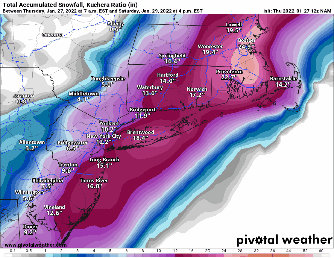
so 18z actually moves things east a bit, drops me down 2 inches or so, also drops totals a lot for Mass and eastern CT.Frank_Wx wrote:
jmanley32- Senior Enthusiast
- Posts : 20513
Reputation : 108
Join date : 2013-12-12
Age : 42
Location : Yonkers, NY
Re: Tracking JAN 29th 2022 'The Phase'
![]() by jmanley32 Thu Jan 27, 2022 3:34 pm
by jmanley32 Thu Jan 27, 2022 3:34 pm
man that is such a sharp cut off and for NYC area thats way to close for comfort, your in one heck a nice spot. I hope this can pull forther west, and you guys would still be in the better spot, this has a wide area of very heavy totals.aiannone wrote:WOW!
jmanley32- Senior Enthusiast
- Posts : 20513
Reputation : 108
Join date : 2013-12-12
Age : 42
Location : Yonkers, NY
Re: Tracking JAN 29th 2022 'The Phase'
![]() by aiannone Thu Jan 27, 2022 3:34 pm
by aiannone Thu Jan 27, 2022 3:34 pm

_________________
-Alex Iannone-
aiannone- Senior Enthusiast - Mod
- Posts : 4813
Reputation : 92
Join date : 2013-01-07
Location : Saint James, LI (Northwest Suffolk Co.)
Re: Tracking JAN 29th 2022 'The Phase'
![]() by CPcantmeasuresnow Thu Jan 27, 2022 3:35 pm
by CPcantmeasuresnow Thu Jan 27, 2022 3:35 pm
aiannone wrote:
Oh Good Lord, that map makes me want to cry, and not tears of joy mind you.
Happy for everyone east of NYC but that is one tough dividing line.
CPcantmeasuresnow- Wx Statistician Guru
- Posts : 7274
Reputation : 230
Join date : 2013-01-07
Age : 103
Location : Eastern Orange County, NY
Re: Tracking JAN 29th 2022 'The Phase'
![]() by jmanley32 Thu Jan 27, 2022 3:36 pm
by jmanley32 Thu Jan 27, 2022 3:36 pm
hey we cant lose hope some eps show some of those blues well into nyc area, keep pulling guys!! why does this show so much more than pivotal wx?aiannone wrote:
Last edited by jmanley32 on Thu Jan 27, 2022 3:41 pm; edited 1 time in total
jmanley32- Senior Enthusiast
- Posts : 20513
Reputation : 108
Join date : 2013-12-12
Age : 42
Location : Yonkers, NY
Re: Tracking JAN 29th 2022 'The Phase'
![]() by frank 638 Thu Jan 27, 2022 3:37 pm
by frank 638 Thu Jan 27, 2022 3:37 pm
frank 638- Senior Enthusiast
- Posts : 2824
Reputation : 37
Join date : 2016-01-01
Age : 40
Location : bronx ny
jmanley32 likes this post
Re: Tracking JAN 29th 2022 'The Phase'
![]() by frank 638 Thu Jan 27, 2022 3:39 pm
by frank 638 Thu Jan 27, 2022 3:39 pm
we got some fishing let’s bring the beast injmanley32 wrote:so 18z actually moves things east a bit, drops me down 2 inches or so, also drops totals a lot for Mass and eastern CT.Frank_Wx wrote:
frank 638- Senior Enthusiast
- Posts : 2824
Reputation : 37
Join date : 2016-01-01
Age : 40
Location : bronx ny
Re: Tracking JAN 29th 2022 'The Phase'
![]() by jmanley32 Thu Jan 27, 2022 3:40 pm
by jmanley32 Thu Jan 27, 2022 3:40 pm
jmanley32- Senior Enthusiast
- Posts : 20513
Reputation : 108
Join date : 2013-12-12
Age : 42
Location : Yonkers, NY
Re: Tracking JAN 29th 2022 'The Phase'
![]() by aiannone Thu Jan 27, 2022 3:40 pm
by aiannone Thu Jan 27, 2022 3:40 pm
URGENT - WINTER WEATHER MESSAGE
National Weather Service Mount Holly NJ
337 PM EST Thu Jan 27 2022
DEZ003-004-NJZ013-014-020-022>027-281000-
/O.UPG.KPHI.WS.A.0003.220129T0000Z-220130T0000Z/
/O.NEW.KPHI.WS.W.0004.220129T0000Z-220130T0000Z/
Inland Sussex-Delaware Beaches-Western Monmouth-Eastern Monmouth-
Ocean-Atlantic-Cape May-Atlantic Coastal Cape May-
Coastal Atlantic-Coastal Ocean-Southeastern Burlington-
Including the cities of Georgetown, Rehoboth Beach, Freehold,
Sandy Hook, Jackson, Hammonton, Cape May Court House, Ocean City,
Atlantic City, Long Beach Island, and Wharton State Forest
337 PM EST Thu Jan 27 2022
...WINTER STORM WARNING IN EFFECT FROM 7 PM FRIDAY TO 7 PM EST
SATURDAY...
* WHAT...Heavy snow expected. Total snow accumulations of 9 to 15
inches. Winds gusting as high as 50 mph.
* WHERE...Portions of central and southern New Jersey and
southern Delaware.
* WHEN...From 7 PM Friday to 7 PM EST Saturday.
* IMPACTS...Travel could be very difficult to impossible. Gusty
winds could bring down tree branches.
* ADDITIONAL DETAILS...Snow is expected to begin Friday evening in
Delmarva and southern New Jersey, spreading northward overnight
into Saturday morning. Snow may be heavy at times through mid
afternoon Saturday before diminishing Saturday evening. Strong
winds may generate blowing snow and very low visibilities at
times.
_________________
-Alex Iannone-
aiannone- Senior Enthusiast - Mod
- Posts : 4813
Reputation : 92
Join date : 2013-01-07
Location : Saint James, LI (Northwest Suffolk Co.)
Re: Tracking JAN 29th 2022 'The Phase'
![]() by SENJsnowman Thu Jan 27, 2022 3:42 pm
by SENJsnowman Thu Jan 27, 2022 3:42 pm
Last edited by SENJsnowman on Thu Jan 27, 2022 3:43 pm; edited 1 time in total
SENJsnowman- Senior Enthusiast
- Posts : 1186
Reputation : 61
Join date : 2017-01-06
Age : 51
Location : Bayville, NJ
Re: Tracking JAN 29th 2022 'The Phase'
![]() by heehaw453 Thu Jan 27, 2022 3:42 pm
by heehaw453 Thu Jan 27, 2022 3:42 pm
heehaw453- Advanced Forecaster
- Posts : 3906
Reputation : 86
Join date : 2014-01-20
Location : Bedminster Township, PA Elevation 600' ASL
Page 26 of 31 • 1 ... 14 ... 25, 26, 27 ... 31 ![]()
|
|
|