Long Range Thread 24.0
+38
richb521
freezerburn
moleson
WeatherBob
Grselig
essexcountypete
algae888
frank 638
docstox12
jimv45
SENJsnowman
MattyICE
adamfitz1969
Dunnzoo
CPcantmeasuresnow
dsix85
Koroptim
phil155
dkodgis
weatherwatchermom
mmanisca
sroc4
mikeypizano
nutleyblizzard
jmanley32
TheAresian
heehaw453
Snow88
hyde345
Sparky Sparticles
SoulSingMG
aiannone
lglickman1
Irish
rb924119
amugs
SNOW MAN
Frank_Wx
42 posters
Page 17 of 21
Page 17 of 21 •  1 ... 10 ... 16, 17, 18, 19, 20, 21
 Re: Long Range Thread 24.0
jmanley32 wrote:So im a bit confused the system that may be Sig ice is 26th and then something next day? I'm planning travel to CT thursday and coming back Sat. I can change my plans at latest Thursday evening. What do you guys think?
Lol. I think you should Wait until a Thursday to change your plans.
sroc4- Admin

- Posts : 8354
Join date : 2013-01-07
 Re: Long Range Thread 24.0
There's nothing to jinx with Friday IMO as expectations are pretty low for most of the forum. I've started a thread to help filter the conversation better.
>>>Feb 25 Event
>>>Feb 25 Event
heehaw453- Advanced Forecaster

- Posts : 3906
Join date : 2014-01-20
 Re: Long Range Thread 24.0
Yeah guess that could have waited as a question till Thursday, just sometimes people miss it and I never hear. Good call though.sroc4 wrote:jmanley32 wrote:So im a bit confused the system that may be Sig ice is 26th and then something next day? I'm planning travel to CT thursday and coming back Sat. I can change my plans at latest Thursday evening. What do you guys think?
Lol. I think you should Wait until a Thursday to change your plans.

jmanley32- Senior Enthusiast

- Posts : 20535
Reputation : 108
Join date : 2013-12-12
Age : 43
Location : Yonkers, NY
 Re: Long Range Thread 24.0
_________________
Mugs
AKA:King: Snow Weenie
Self Proclaimed
WINTER 2014-15 : 55.12" +.02 for 6 coatings (avg. 35")
WINTER 2015-16 Total - 29.8" (Avg 35")
WINTER 2016-17 : 39.5" so far

amugs- Advanced Forecaster - Mod

- Posts : 15095
Reputation : 213
Join date : 2013-01-07
Age : 54
Location : Hillsdale,NJ
 Re: Long Range Thread 24.0
I am also seeing that in the longer range, Mugs.
Decent storm signal toward the second week of March.
Decent storm signal toward the second week of March.
_________________
_______________________________________________________________________________________________________
CLICK HERE to view NJ Strong Snowstorm Classifications
heehaw453- Advanced Forecaster

- Posts : 3906
Reputation : 86
Join date : 2014-01-20
Location : Bedminster Township, PA Elevation 600' ASL
 Re: Long Range Thread 24.0
The long range crew is seeing a lot of fun for the last weeks of winter! Great news.

docstox12- Wx Statistician Guru

- Posts : 8530
Reputation : 222
Join date : 2013-01-07
Age : 73
Location : Monroe NY
 Re: Long Range Thread 24.0
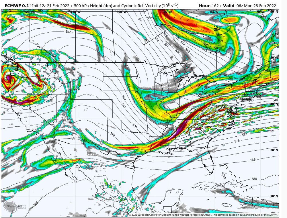
I liked the 12Z Euro Op for D6/7 on the 2/27ish threat. Minor adjustments like sharpening up the trough would bring that L up the coast for a nice snowstorm. The take away is a nice PNA ridge with a lot of energy out ahead of the trough. We've been playing this game a lot this winter, so why is this different? One big thing is it's getting towards March and longer wavelengths are not needed as much as December/January/Early February for amplification of a s/w. That means troughs tend to sharpen faster giving more room for up rather than out. So my thought this will trend north...

heehaw453- Advanced Forecaster

- Posts : 3906
Reputation : 86
Join date : 2014-01-20
Location : Bedminster Township, PA Elevation 600' ASL
 Re: Long Range Thread 24.0
heehaw453 wrote:I liked the 12Z Euro Op for D6/7 on the 2/27ish threat. Minor adjustments like sharpening up the trough would bring that L up the coast for a nice snowstorm. The take away is a nice PNA ridge with a lot of energy out ahead of the trough. We've been playing this game a lot this winter, so why is this different? One big thing is it's getting towards March and longer wavelengths are not needed as much as December/January/Early February for amplification of a s/w. That means troughs tend to sharpen faster giving more room for up rather than out. So my thought this will trend north...
Or, as per the relatively common trends this season, that energy coming ashore the WC is faster, esp that northern piece in Canada; ruins the party by acting to move things along too quick by knocking down the ridge and everything happens too far off the EC coast. This one looks like a set up similar to past where eastern sections have the best shot or OTS
_________________
"In weather and in life, there's no winning and losing; there's only winning and learning."
WINTER 2012/2013 TOTALS 43.65"WINTER 2017/2018 TOTALS 62.85" WINTER 2022/2023 TOTALS 4.9"
WINTER 2013/2014 TOTALS 64.85"WINTER 2018/2019 TOTALS 14.25" WINTER 2023/2024 TOTALS 13.1"
WINTER 2014/2015 TOTALS 71.20"WINTER 2019/2020 TOTALS 6.35"
WINTER 2015/2016 TOTALS 35.00"WINTER 2020/2021 TOTALS 37.75"
WINTER 2016/2017 TOTALS 42.25"WINTER 2021/2022 TOTALS 31.65"

sroc4- Admin

- Posts : 8354
Reputation : 302
Join date : 2013-01-07
Location : Wading River, LI
 Re: Long Range Thread 24.0
sroc4 wrote:heehaw453 wrote:I liked the 12Z Euro Op for D6/7 on the 2/27ish threat. Minor adjustments like sharpening up the trough would bring that L up the coast for a nice snowstorm. The take away is a nice PNA ridge with a lot of energy out ahead of the trough. We've been playing this game a lot this winter, so why is this different? One big thing is it's getting towards March and longer wavelengths are not needed as much as December/January/Early February for amplification of a s/w. That means troughs tend to sharpen faster giving more room for up rather than out. So my thought this will trend north...
Or as per the relatively common trends that energy coming ashore the WC is faster, esp that northern piece in Canada, ruins the party that acts to move things along too quick and everything happens off the coast.
Oh definitely it's low threat for now. Just some of the base componentry is there and this time of year is more conducive to more tucked solutions. We'll need a few days to see if this has legs...
heehaw453- Advanced Forecaster

- Posts : 3906
Reputation : 86
Join date : 2014-01-20
Location : Bedminster Township, PA Elevation 600' ASL
sroc4 likes this post
 Re: Long Range Thread 24.0
heehaw453 wrote:sroc4 wrote:heehaw453 wrote:I liked the 12Z Euro Op for D6/7 on the 2/27ish threat. Minor adjustments like sharpening up the trough would bring that L up the coast for a nice snowstorm. The take away is a nice PNA ridge with a lot of energy out ahead of the trough. We've been playing this game a lot this winter, so why is this different? One big thing is it's getting towards March and longer wavelengths are not needed as much as December/January/Early February for amplification of a s/w. That means troughs tend to sharpen faster giving more room for up rather than out. So my thought this will trend north...
Or as per the relatively common trends that energy coming ashore the WC is faster, esp that northern piece in Canada, ruins the party that acts to move things along too quick and everything happens off the coast.
Oh definitely it's low threat for now. Just some of the base componentry is there and this time of year is more conducive to more tucked solutions. We'll need a few days to see if this has legs...
Ill tell you what though if that vort max was just a little further NE, like say in the Tenn valley, then that system goes boom.
_________________
"In weather and in life, there's no winning and losing; there's only winning and learning."
WINTER 2012/2013 TOTALS 43.65"WINTER 2017/2018 TOTALS 62.85" WINTER 2022/2023 TOTALS 4.9"
WINTER 2013/2014 TOTALS 64.85"WINTER 2018/2019 TOTALS 14.25" WINTER 2023/2024 TOTALS 13.1"
WINTER 2014/2015 TOTALS 71.20"WINTER 2019/2020 TOTALS 6.35"
WINTER 2015/2016 TOTALS 35.00"WINTER 2020/2021 TOTALS 37.75"
WINTER 2016/2017 TOTALS 42.25"WINTER 2021/2022 TOTALS 31.65"

sroc4- Admin

- Posts : 8354
Reputation : 302
Join date : 2013-01-07
Location : Wading River, LI
heehaw453 likes this post
 Re: Long Range Thread 24.0
Sundays storm is back on the models

Snow88- Senior Enthusiast

- Posts : 2193
Reputation : 4
Join date : 2013-01-09
Age : 35
Location : Brooklyn, NY
heehaw453- Advanced Forecaster

- Posts : 3906
Reputation : 86
Join date : 2014-01-20
Location : Bedminster Township, PA Elevation 600' ASL
SENJsnowman likes this post
 Re: Long Range Thread 24.0
2/27 threat on ice for now. Doesn't seem as impressive on 500mb for now. However, March is going to offer up another chance or two IMO as cold looks to get established. That doesn't mean a hit for this area as we all know.
heehaw453- Advanced Forecaster

- Posts : 3906
Reputation : 86
Join date : 2014-01-20
Location : Bedminster Township, PA Elevation 600' ASL
 Re: Long Range Thread 24.0
I'm still intrigued by this 2/27-2/28 possibility. The upper air pattern looks better to me than the model's surface depiction which makes me not want to write that off just yet. it also would be following a traditional model pattern over the years: Storm ten days out, no storm 7 days out, storm comes back 5 days out. lol. Models seem to love losing storms in that 7 day range.

billg315- Advanced Forecaster - Mod

- Posts : 4483
Reputation : 185
Join date : 2015-01-24
Age : 50
Location : Flemington, NJ
heehaw453 likes this post
heehaw453- Advanced Forecaster

- Posts : 3906
Reputation : 86
Join date : 2014-01-20
Location : Bedminster Township, PA Elevation 600' ASL
 Re: Long Range Thread 24.0
_________________
Mugs
AKA:King: Snow Weenie
Self Proclaimed
WINTER 2014-15 : 55.12" +.02 for 6 coatings (avg. 35")
WINTER 2015-16 Total - 29.8" (Avg 35")
WINTER 2016-17 : 39.5" so far

amugs- Advanced Forecaster - Mod

- Posts : 15095
Reputation : 213
Join date : 2013-01-07
Age : 54
Location : Hillsdale,NJ
heehaw453- Advanced Forecaster

- Posts : 3906
Reputation : 86
Join date : 2014-01-20
Location : Bedminster Township, PA Elevation 600' ASL
 Re: Long Range Thread 24.0
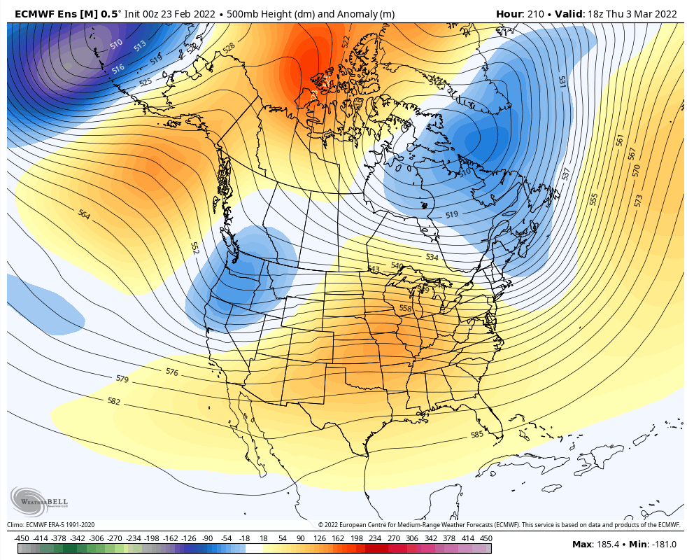
2/27 is probably dead. No support that I'm aware for it on guidance at D4. The winter has just been misaligned on the PAC/NAM states. There is evidence of a better NAM state beginning of March. We obviously don't want a hostile PNA as that will mitigate cold air and storms opportunities. If the PNA can remove that trough and pump a bit, then we'd have something.

heehaw453- Advanced Forecaster

- Posts : 3906
Reputation : 86
Join date : 2014-01-20
Location : Bedminster Township, PA Elevation 600' ASL
 Re: Long Range Thread 24.0
Vortex split?? If so Rbs call goes through to the ionosphere!!


_________________
Mugs
AKA:King: Snow Weenie
Self Proclaimed
WINTER 2014-15 : 55.12" +.02 for 6 coatings (avg. 35")
WINTER 2015-16 Total - 29.8" (Avg 35")
WINTER 2016-17 : 39.5" so far

amugs- Advanced Forecaster - Mod

- Posts : 15095
Reputation : 213
Join date : 2013-01-07
Age : 54
Location : Hillsdale,NJ
 Re: Long Range Thread 24.0
Oh baby look at the positives over the top!!


_________________
Mugs
AKA:King: Snow Weenie
Self Proclaimed
WINTER 2014-15 : 55.12" +.02 for 6 coatings (avg. 35")
WINTER 2015-16 Total - 29.8" (Avg 35")
WINTER 2016-17 : 39.5" so far

amugs- Advanced Forecaster - Mod

- Posts : 15095
Reputation : 213
Join date : 2013-01-07
Age : 54
Location : Hillsdale,NJ
 Re: Long Range Thread 24.0
I'm happy to see folks pumped for March. However, all I'm seeing is warmer temps into March. What am I missing?

Irish- Pro Enthusiast

- Posts : 788
Reputation : 19
Join date : 2019-01-16
Age : 45
Location : Old Bridge, NJ
 Re: Long Range Thread 24.0
Irish wrote:I'm happy to see folks pumped for March. However, all I'm seeing is warmer temps into March. What am I missing?
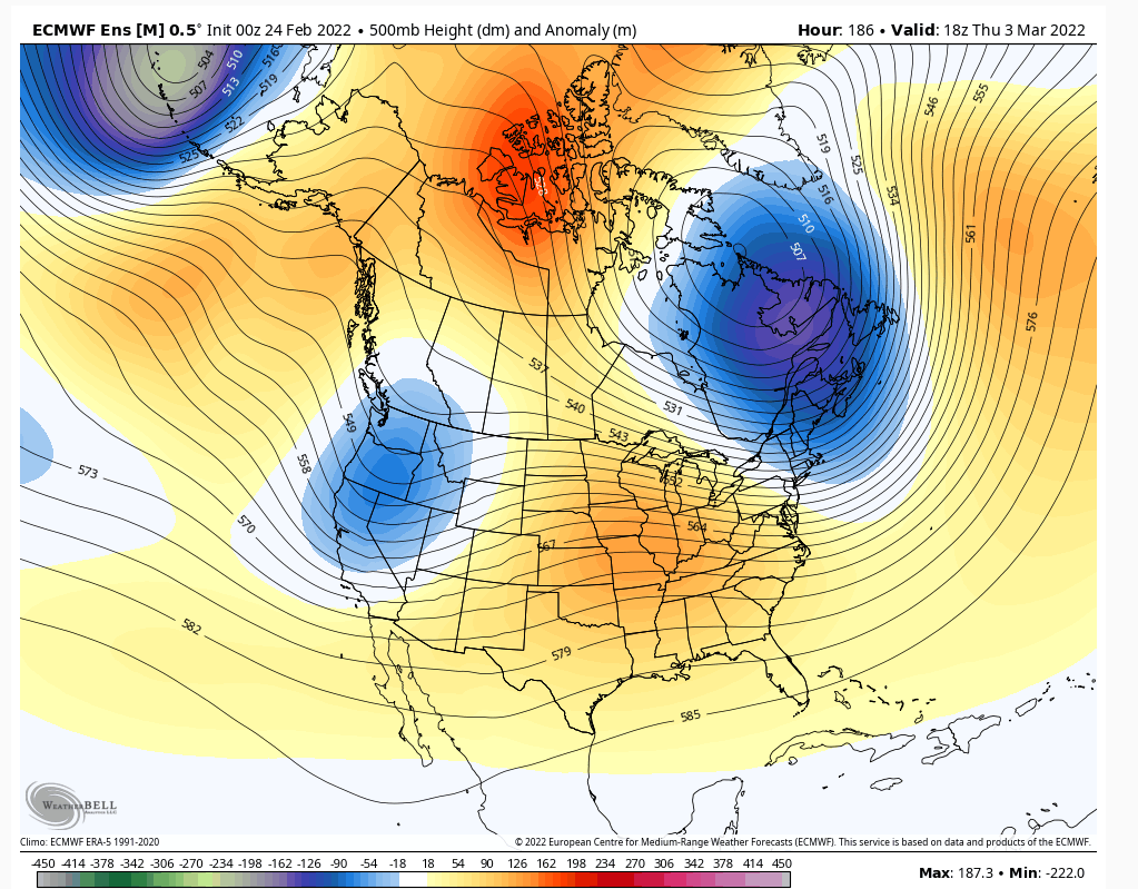
This picture for early March is the epitome of this winter. Looks like a good NAM state developing with a very nice -EPO, but now the PNA won't cooperate. That mitigates our chances big time with storms and cold air transfer to east. This winter hasn't not been able to bring it all together. It's too bad because with the PAC we've had even slight cooperation from the NAM and I feel most of us would be well above our respective snowfall averages. Like 150%-175% kind of anomaly across the board. My optimism isn't good from what I see now, but maybe we get lucky in the next few weeks...
The winter of 2015 had a very good PAC with poor NAM support and produced nicely. However, that had very fortuitous placement of the TPV to help with blocking. That doesn't happen often around these parts. You normally need the AO/NAO support.
heehaw453- Advanced Forecaster

- Posts : 3906
Reputation : 86
Join date : 2014-01-20
Location : Bedminster Township, PA Elevation 600' ASL
 Re: Long Range Thread 24.0
heehaw453 wrote:Irish wrote:I'm happy to see folks pumped for March. However, all I'm seeing is warmer temps into March. What am I missing?
This picture for early March is the epitome of this winter. Looks like a good NAM state developing with a very nice -EPO, but now the PNA won't cooperate. That mitigates our chances big time with storms and cold air transfer to east. This winter hasn't not been able to bring it all together. It's too bad because with the PAC we've had even slight cooperation from the NAM and I feel most of us would be well above our respective snowfall averages. Like 150%-175% kind of anomaly across the board. My optimism isn't good from what I see now, but maybe we get lucky in the next few weeks...
The winter of 2015 had a very good PAC with poor NAM support and produced nicely. However, that had very fortuitous placement of the TPV to help with blocking. That doesn't happen often around these parts. You normally need the AO/NAO support.
Gotcha, whatever happens, happens. However, at this point, bring on spring!

Irish- Pro Enthusiast

- Posts : 788
Reputation : 19
Join date : 2019-01-16
Age : 45
Location : Old Bridge, NJ
 Re: Long Range Thread 24.0
AO looks to get Negative and Neutral from March 3rdish onward along with the NAO


EPO is negative

WPO takes until March 4th to do so but these two can cause widespread cold and a split flow in March is likely with a jet coming out of Baja


EPO is negative

WPO takes until March 4th to do so but these two can cause widespread cold and a split flow in March is likely with a jet coming out of Baja

_________________
Mugs
AKA:King: Snow Weenie
Self Proclaimed
WINTER 2014-15 : 55.12" +.02 for 6 coatings (avg. 35")
WINTER 2015-16 Total - 29.8" (Avg 35")
WINTER 2016-17 : 39.5" so far

amugs- Advanced Forecaster - Mod

- Posts : 15095
Reputation : 213
Join date : 2013-01-07
Age : 54
Location : Hillsdale,NJ
 Re: Long Range Thread 24.0
Long range is zapping whatever enthusiasm I have left to give this winter. If or when the negative PNA emerges, along with a continue positive NAO, that will effectively end our chances of meaningful snowfall. Sure the nuisance snowfall here and there but the big storms will wait until next year. We’ll see if the ensemble outlook changes but for now…not good.
_________________
_______________________________________________________________________________________________________
CLICK HERE to view NJ Strong Snowstorm Classifications
 Re: Long Range Thread 24.0
Frank_Wx wrote:Long range is zapping whatever enthusiasm I have left to give this winter. If or when the negative PNA emerges, along with a continue positive NAO, that will effectively end our chances of meaningful snowfall. Sure the nuisance snowfall here and there but the big storms will wait until next year. We’ll see if the ensemble outlook changes but for now…not good.
Thx for all you guys have done this winter, see you next winter!

Irish- Pro Enthusiast

- Posts : 788
Reputation : 19
Join date : 2019-01-16
Age : 45
Location : Old Bridge, NJ
Page 17 of 21 •  1 ... 10 ... 16, 17, 18, 19, 20, 21
Page 17 of 21
Permissions in this forum:
You cannot reply to topics in this forum|
|
|

 Home
Home


