
 Search
Long Range Thread 24.0
Page 18 of 21 •  1 ... 10 ... 17, 18, 19, 20, 21
 ![]()
Re: Long Range Thread 24.0
![]() by Frank_Wx Thu Feb 24, 2022 7:39 pm
by Frank_Wx Thu Feb 24, 2022 7:39 pm
Frank_Wx- Godzilla Seeker

- Posts : 21305
Join date : 2013-01-05 -

Re: Long Range Thread 24.0
![]() by Irish Thu Feb 24, 2022 8:13 pm
by Irish Thu Feb 24, 2022 8:13 pm
Frank_Wx wrote:Long range is zapping whatever enthusiasm I have left to give this winter. If or when the negative PNA emerges, along with a continue positive NAO, that will effectively end our chances of meaningful snowfall. Sure the nuisance snowfall here and there but the big storms will wait until next year. We’ll see if the ensemble outlook changes but for now…not good.
Thx for all you guys have done this winter, see you next winter!
Irish- Pro Enthusiast

- Posts : 788
Join date : 2019-01-16
Re: Long Range Thread 24.0
![]() by Snow88 Thu Feb 24, 2022 8:28 pm
by Snow88 Thu Feb 24, 2022 8:28 pm
Frank_Wx wrote:Long range is zapping whatever enthusiasm I have left to give this winter. If or when the negative PNA emerges, along with a continue positive NAO, that will effectively end our chances of meaningful snowfall. Sure the nuisance snowfall here and there but the big storms will wait until next year. We’ll see if the ensemble outlook changes but for now…not good.
A few storm threats in early March then we have to see if the models are right with the AO going negative.

Snow88- Senior Enthusiast

- Posts : 2193
Reputation : 4
Join date : 2013-01-09
Age : 35
Location : Brooklyn, NY
Re: Long Range Thread 24.0
![]() by Snow88 Thu Feb 24, 2022 8:30 pm
by Snow88 Thu Feb 24, 2022 8:30 pm
Irish wrote:Frank_Wx wrote:Long range is zapping whatever enthusiasm I have left to give this winter. If or when the negative PNA emerges, along with a continue positive NAO, that will effectively end our chances of meaningful snowfall. Sure the nuisance snowfall here and there but the big storms will wait until next year. We’ll see if the ensemble outlook changes but for now…not good.
Thx for all you guys have done this winter, see you next winter!
Winter isn't even over yet
Snow88- Senior Enthusiast
- Posts : 2193
Reputation : 4
Join date : 2013-01-09
Age : 35
Location : Brooklyn, NY
Re: Long Range Thread 24.0
![]() by heehaw453 Fri Feb 25, 2022 7:56 am
by heehaw453 Fri Feb 25, 2022 7:56 am


heehaw453- Advanced Forecaster

- Posts : 3906
Reputation : 86
Join date : 2014-01-20
Location : Bedminster Township, PA Elevation 600' ASL
Re: Long Range Thread 24.0
![]() by amugs Fri Feb 25, 2022 9:38 am
by amugs Fri Feb 25, 2022 9:38 am
Indices have flipped in the AO and NAO to a N to Neutral state and the PV is always a wildcard. Never give up....NEVER.
One thing we need to fix is the trough in the WC, lessen that up and the EPO/WPO/AO/NAO state can bring a good storm.also wavelengths are shortening.
MJO phase 5 ...can not upload any files.
_________________
Mugs
AKA:King: Snow Weenie
Self Proclaimed
WINTER 2014-15 : 55.12" +.02 for 6 coatings (avg. 35")
WINTER 2015-16 Total - 29.8" (Avg 35")
WINTER 2016-17 : 39.5" so far

amugs- Advanced Forecaster - Mod

- Posts : 15095
Reputation : 213
Join date : 2013-01-07
Age : 54
Location : Hillsdale,NJ
kalleg likes this post
Re: Long Range Thread 24.0
![]() by heehaw453 Fri Feb 25, 2022 10:27 am
by heehaw453 Fri Feb 25, 2022 10:27 am
amugs wrote:How can you give up on March?? It is notorious for massive warm tropical air air and cold arctic air clashes that produce big storms.
Indices have flipped in the AO and NAO to a N to Neutral state and the PV is always a wildcard. Never give up....NEVER.
One thing we need to fix is the trough in the WC, lessen that up and the EPO/WPO/AO/NAO state can bring a good storm.also wavelengths are shortening.
MJO phase 5 ...can not upload any files.
IMO Mugs if we can keep a consistent NAM support for the first 3 weeks of March then the interior and potentially I-95 will have the real threat of a sig snowstorm before we call this a day. If we have to rely on the PAC only in March, then we are done w.r.t. sig snow threats until next year. I'm watching that NAM state and so far I think it's workable for a threat to two.
heehaw453- Advanced Forecaster
- Posts : 3906
Reputation : 86
Join date : 2014-01-20
Location : Bedminster Township, PA Elevation 600' ASL
amugs likes this post
Re: Long Range Thread 24.0
![]() by dkodgis Fri Feb 25, 2022 11:20 am
by dkodgis Fri Feb 25, 2022 11:20 am

dkodgis- Senior Enthusiast
- Posts : 2560
Reputation : 98
Join date : 2013-12-29
heehaw453 likes this post
Re: Long Range Thread 24.0
![]() by amugs Fri Feb 25, 2022 5:00 pm
by amugs Fri Feb 25, 2022 5:00 pm
AO and NAO going Neutral to Negative. PNA going Neutral


_________________
Mugs
AKA:King: Snow Weenie
Self Proclaimed
WINTER 2014-15 : 55.12" +.02 for 6 coatings (avg. 35")
WINTER 2015-16 Total - 29.8" (Avg 35")
WINTER 2016-17 : 39.5" so far
amugs- Advanced Forecaster - Mod
- Posts : 15095
Reputation : 213
Join date : 2013-01-07
Age : 54
Location : Hillsdale,NJ
heehaw453, SENJsnowman and phil155 like this post
Re: Long Range Thread 24.0
![]() by amugs Sat Feb 26, 2022 10:36 am
by amugs Sat Feb 26, 2022 10:36 am

_________________
Mugs
AKA:King: Snow Weenie
Self Proclaimed
WINTER 2014-15 : 55.12" +.02 for 6 coatings (avg. 35")
WINTER 2015-16 Total - 29.8" (Avg 35")
WINTER 2016-17 : 39.5" so far
amugs- Advanced Forecaster - Mod
- Posts : 15095
Reputation : 213
Join date : 2013-01-07
Age : 54
Location : Hillsdale,NJ
Re: Long Range Thread 24.0
![]() by heehaw453 Sat Feb 26, 2022 1:56 pm
by heehaw453 Sat Feb 26, 2022 1:56 pm


heehaw453- Advanced Forecaster
- Posts : 3906
Reputation : 86
Join date : 2014-01-20
Location : Bedminster Township, PA Elevation 600' ASL
Re: Long Range Thread 24.0
![]() by heehaw453 Sat Feb 26, 2022 2:11 pm
by heehaw453 Sat Feb 26, 2022 2:11 pm
heehaw453- Advanced Forecaster
- Posts : 3906
Reputation : 86
Join date : 2014-01-20
Location : Bedminster Township, PA Elevation 600' ASL
Re: Long Range Thread 24.0
![]() by dkodgis Sat Feb 26, 2022 2:50 pm
by dkodgis Sat Feb 26, 2022 2:50 pm
dkodgis- Senior Enthusiast
- Posts : 2560
Reputation : 98
Join date : 2013-12-29
Sparky Sparticles and Meepers55 like this post
Re: Long Range Thread 24.0
![]() by heehaw453 Sat Feb 26, 2022 2:55 pm
by heehaw453 Sat Feb 26, 2022 2:55 pm
dkodgis wrote:Bad news for the spring early birds; good news for snow lovers. CP is launching a therapy group to talk those of us who feel hurt, betrayed, and bewildered down off the first-floor window ledge regarding this ever so meager winter’s snowfall.

heehaw453- Advanced Forecaster
- Posts : 3906
Reputation : 86
Join date : 2014-01-20
Location : Bedminster Township, PA Elevation 600' ASL
kalleg likes this post
Re: Long Range Thread 24.0
![]() by heehaw453 Sun Feb 27, 2022 7:57 am
by heehaw453 Sun Feb 27, 2022 7:57 am
But also notice what IMO kills the next 5-7 days after including the March 10 threat as the west coast trough starts its dirty work again. The air mass will become marginal in east coast and won't support snow well until you get to CNE. Play it again it Sam...

heehaw453- Advanced Forecaster
- Posts : 3906
Reputation : 86
Join date : 2014-01-20
Location : Bedminster Township, PA Elevation 600' ASL
Re: Long Range Thread 24.0
![]() by SENJsnowman Mon Feb 28, 2022 8:11 am
by SENJsnowman Mon Feb 28, 2022 8:11 am
SENJsnowman- Senior Enthusiast
- Posts : 1189
Reputation : 61
Join date : 2017-01-06
Age : 51
Location : Bayville, NJ
mmanisca likes this post
Re: Long Range Thread 24.0
![]() by heehaw453 Mon Feb 28, 2022 10:28 am
by heehaw453 Mon Feb 28, 2022 10:28 am
SENJsnowman wrote:As per the TWC app, the dead of winter basically lifts out of here come this Saturday. Nighttime lows stay well above freezing at the coast and daytime highs consistently range from the high 40’s to the high 50’s. Not exactly spring like temps, but a noticeable warm up anyways. Interested to see if this holds…
100%.
This is consistent with the PNA going hostile and blocking the cold air from eastward progression. Notice what you see in this picture. The diagonal hookup with the TPV to the PNA is a kiss of death for cold air progression as the SE ridge can flex it's muscle for long periods. In this case the -EPO doesn't help us in time. The trough will probably swing through to clear the SE ridge and cold air can advance with a better PNA during mid-March. It's not impossible for latter part of March snowstorm for interior, but it's fighting climo and the pattern isn't good enough to produce anything sig after 3/15 IMO expect for CNE/NNE. Again not impossible just very unlikely...
I'm going to create a meteorological winter retro/grade thread and probably getting ready to close up shop.

heehaw453- Advanced Forecaster
- Posts : 3906
Reputation : 86
Join date : 2014-01-20
Location : Bedminster Township, PA Elevation 600' ASL
Re: Long Range Thread 24.0
![]() by Wheezer Mon Feb 28, 2022 2:02 pm
by Wheezer Mon Feb 28, 2022 2:02 pm
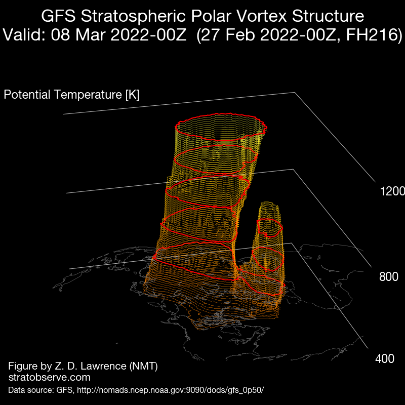
The strat. vortex is currently stronger than all other years in the ERA interim record!!!
The zonal mean zonal wind at 10 hPa 60N is today (GFS analysis): 54.7 m/s
Weakest zonal wind at 10 hPa 60N in ERA interim record for todays date is: -10.6 m/s 1979
Strongest zonal wind at 10 hPa 60N in ERA interim record for todays date is: 47.3 m/s 1997
Wheezer- Posts : 30
Reputation : 6
Join date : 2017-11-08
Location : Cincinnati, Oh
Re: Long Range Thread 24.0
![]() by amugs Mon Feb 28, 2022 9:07 pm
by amugs Mon Feb 28, 2022 9:07 pm
Wheezer wrote:Another record day in the life of the PV. One or two more in the coming days before a brief weakening in about a week, with a recovery after that projected .
The strat. vortex is currently stronger than all other years in the ERA interim record!!!
The zonal mean zonal wind at 10 hPa 60N is today (GFS analysis): 54.7 m/s
Weakest zonal wind at 10 hPa 60N in ERA interim record for todays date is: -10.6 m/s 1979
Strongest zonal wind at 10 hPa 60N in ERA interim record for todays date is: 47.3 m/s 1997
Then project tonight is a split starting next week and two lobes protected.

_________________
Mugs
AKA:King: Snow Weenie
Self Proclaimed
WINTER 2014-15 : 55.12" +.02 for 6 coatings (avg. 35")
WINTER 2015-16 Total - 29.8" (Avg 35")
WINTER 2016-17 : 39.5" so far
amugs- Advanced Forecaster - Mod
- Posts : 15095
Reputation : 213
Join date : 2013-01-07
Age : 54
Location : Hillsdale,NJ
Re: Long Range Thread 24.0
![]() by Wheezer Tue Mar 01, 2022 5:42 am
by Wheezer Tue Mar 01, 2022 5:42 am
The strat. vortex is currently stronger than all other years in the ERA interim record!!!
The zonal mean zonal wind at 10 hPa 60N is today (GFS analysis): 54.1 m/s
Weakest zonal wind at 10 hPa 60N in ERA interim record for todays date is: -11.4 m/s 1999
Strongest zonal wind at 10 hPa 60N in ERA interim record for todays date is: 49.9 m/s 2020
Wheezer- Posts : 30
Reputation : 6
Join date : 2017-11-08
Location : Cincinnati, Oh
Re: Long Range Thread 24.0
![]() by CPcantmeasuresnow Tue Mar 01, 2022 7:36 am
by CPcantmeasuresnow Tue Mar 01, 2022 7:36 am
Wheezer wrote:Today's PV
The strat. vortex is currently stronger than all other years in the ERA interim record!!!
The zonal mean zonal wind at 10 hPa 60N is today (GFS analysis): 54.1 m/s
Weakest zonal wind at 10 hPa 60N in ERA interim record for todays date is: -11.4 m/s 1999
Strongest zonal wind at 10 hPa 60N in ERA interim record for todays date is: 49.9 m/s 2020
I wish I had the slightest idea what this means and in what time frame but I don't.
Could you please explain?

CPcantmeasuresnow- Wx Statistician Guru

- Posts : 7274
Reputation : 230
Join date : 2013-01-07
Age : 103
Location : Eastern Orange County, NY
Re: Long Range Thread 24.0
![]() by Wheezer Tue Mar 01, 2022 8:05 am
by Wheezer Tue Mar 01, 2022 8:05 am
Wheezer- Posts : 30
Reputation : 6
Join date : 2017-11-08
Location : Cincinnati, Oh
Re: Long Range Thread 24.0
![]() by sroc4 Tue Mar 01, 2022 9:06 am
by sroc4 Tue Mar 01, 2022 9:06 am
CPcantmeasuresnow wrote:Wheezer wrote:Today's PV
The strat. vortex is currently stronger than all other years in the ERA interim record!!!
The zonal mean zonal wind at 10 hPa 60N is today (GFS analysis): 54.1 m/s
Weakest zonal wind at 10 hPa 60N in ERA interim record for todays date is: -11.4 m/s 1999
Strongest zonal wind at 10 hPa 60N in ERA interim record for todays date is: 49.9 m/s 2020
I wish I had the slightest idea what this means and in what time frame but I don't.
Could you please explain?
Meh. The understanding and ability to measure the strat winds etc with any kind of accuracy is in its absolute infancy making a statement like this, with 3 !!! points no less, kind of meaning less IMO. It just feels wrong to make the statement without adding at the end....
"...but in the grand scheme of things with have no idea what the significance of this is because the record of the strat is like one page worth but the rest of the book is filled with hundreds of millions of blank pages. Even having a couple of hundreds of those pages filled in may give us a dimple of understanding its past".
Wheezer Im under the assumption that you did not specifically make the statement. If you did I do not mean any disrespect in my comments, just pointing a few things out.
_________________
"In weather and in life, there's no winning and losing; there's only winning and learning."
WINTER 2012/2013 TOTALS 43.65"WINTER 2017/2018 TOTALS 62.85" WINTER 2022/2023 TOTALS 4.9"
WINTER 2013/2014 TOTALS 64.85"WINTER 2018/2019 TOTALS 14.25" WINTER 2023/2024 TOTALS 13.1"
WINTER 2014/2015 TOTALS 71.20"WINTER 2019/2020 TOTALS 6.35"
WINTER 2015/2016 TOTALS 35.00"WINTER 2020/2021 TOTALS 37.75"
WINTER 2016/2017 TOTALS 42.25"WINTER 2021/2022 TOTALS 31.65"

sroc4- Admin
- Posts : 8354
Reputation : 302
Join date : 2013-01-07
Location : Wading River, LI
Re: Long Range Thread 24.0
![]() by Wheezer Tue Mar 01, 2022 9:51 am
by Wheezer Tue Mar 01, 2022 9:51 am
sroc4 wrote:CPcantmeasuresnow wrote:Wheezer wrote:Today's PV
The strat. vortex is currently stronger than all other years in the ERA interim record!!!
The zonal mean zonal wind at 10 hPa 60N is today (GFS analysis): 54.1 m/s
Weakest zonal wind at 10 hPa 60N in ERA interim record for todays date is: -11.4 m/s 1999
Strongest zonal wind at 10 hPa 60N in ERA interim record for todays date is: 49.9 m/s 2020
I wish I had the slightest idea what this means and in what time frame but I don't.
Could you please explain?
Meh. The understanding and ability to measure the strat winds etc with any kind of accuracy is in its absolute infancy making a statement like this, with 3 !!! points no less, kind of meaning less IMO. It just feels wrong to make the statement without adding at the end....
"...but in the grand scheme of things with have no idea what the significance of this is because the record of the strat is like one page worth but the rest of the book is filled with hundreds of millions of blank pages. Even having a couple of hundreds of those pages filled in may give us a dimple of understanding its past".
Wheezer Im under the assumption that you did not specifically make the statement. If you did I do not mean any disrespect in my comments, just pointing a few things out.
Of course, as far as what it means , to me anyway, see my above post
Wheezer- Posts : 30
Reputation : 6
Join date : 2017-11-08
Location : Cincinnati, Oh
Re: Long Range Thread 24.0
![]() by sroc4 Tue Mar 01, 2022 10:10 am
by sroc4 Tue Mar 01, 2022 10:10 am
Wheezer wrote:It's just a reflection of the ongoing +AO, and although it will weaken in the coming days, it has to right?, models show it being brief and recovering to at least a normal state and thus more +AO in our future, imo
Sorry about that Wheezer. Not sure how I missed this. That is appears now in the modeling I cant argue with your thoughts.
_________________
"In weather and in life, there's no winning and losing; there's only winning and learning."
WINTER 2012/2013 TOTALS 43.65"WINTER 2017/2018 TOTALS 62.85" WINTER 2022/2023 TOTALS 4.9"
WINTER 2013/2014 TOTALS 64.85"WINTER 2018/2019 TOTALS 14.25" WINTER 2023/2024 TOTALS 13.1"
WINTER 2014/2015 TOTALS 71.20"WINTER 2019/2020 TOTALS 6.35"
WINTER 2015/2016 TOTALS 35.00"WINTER 2020/2021 TOTALS 37.75"
WINTER 2016/2017 TOTALS 42.25"WINTER 2021/2022 TOTALS 31.65"
sroc4- Admin
- Posts : 8354
Reputation : 302
Join date : 2013-01-07
Location : Wading River, LI
Re: Long Range Thread 24.0
![]() by sroc4 Wed Mar 02, 2022 7:53 am
by sroc4 Wed Mar 02, 2022 7:53 am
rb924119 wrote:sroc4 wrote:heehaw453 wrote:Yeah with Canada having ample cold air the -EPO would bleed down cold as the SE ridge gets pushed on by TPV in Greenland. I think that could happen in March but not February because I've seen this look get pushed back several times. And my concern with March is when it does actually happen it maybe too late for a lot of folksBut let's see if this starts building more consistency and alignment as we get within say 7 days. Because if it does manifest itself by end February, I-95 would be in the game for its effects.
Ray and Haw great discussions. I still think we have to watch and worry about the PNA domain. The "look" at the H5 anomaly maps towards the end of the month does hint at that -EPO but the negative PNA look is also there. Relative to the previously similar pattern in Dec I certainly recognize climatologically the air mass in Canada headed into March is much colder/denser, and hopefully the extremely anomalous neg PNA (-3 to -4 sigma in Dec) may not be quite as strong; however, that neg PNA may still provides "the trap door" for the coldest anomalies to escape and lead to a storm track less than ideal whenever any amped up energy ejects out of the SW CONUS trough by way of pumping the SE ridge out ahead; esp if interacts/phases with N energy too soon. I will remain skeptical this far out that we wont see a slightly less pronounced version of the Dec pattern develop if we go back to that -EPO/_PNA couplet without and real help from the NAO or AO domains.
Of course this may just be me being gun shy. Ill give it some time before I decide how I overall feel about it. Centers of the higher and lower height anomalies and of course how the orientations of the ridge/trough axis' evolves will go a long way to making up my mind.
The -PNA look IS there, and WILL BE real. However, this is very different from December with respect to the global and hemispheric forcing. In December, the larger backdrop SUPPORTED the anomalous western trough/eastern ridge regime. This time, however, it doesn’t. Globally and hemispherically, the forcing will be acting to establish the anomalous trough in the eastern CONUS. So what should happen, and I covered this a few days ago, is that the western trough should shear out (leading to the gradient pattern at first), and then eventually, the remnants will fold under the western ridge in an anti-cyclonic wave break event. When that happens, the remains of the Southeast Ridge will retrograde west to fill that void over the Southwest, and a unified western ridge/eastern trough will result. When this occurs, it SHOULD present a storm opportunity, probably between March 6th-10th, if I had to guess. The period we are seeing now on the modeling is the transition period, but we are only seeing the first half - the -PNA pattern will only be transient in my opinion.
In doing a little examining of the March pattern I felt this discussion by Ray back MID FEB should be bumped.
_________________
"In weather and in life, there's no winning and losing; there's only winning and learning."
WINTER 2012/2013 TOTALS 43.65"WINTER 2017/2018 TOTALS 62.85" WINTER 2022/2023 TOTALS 4.9"
WINTER 2013/2014 TOTALS 64.85"WINTER 2018/2019 TOTALS 14.25" WINTER 2023/2024 TOTALS 13.1"
WINTER 2014/2015 TOTALS 71.20"WINTER 2019/2020 TOTALS 6.35"
WINTER 2015/2016 TOTALS 35.00"WINTER 2020/2021 TOTALS 37.75"
WINTER 2016/2017 TOTALS 42.25"WINTER 2021/2022 TOTALS 31.65"
sroc4- Admin
- Posts : 8354
Reputation : 302
Join date : 2013-01-07
Location : Wading River, LI
Re: Long Range Thread 24.0
![]() by sroc4 Wed Mar 02, 2022 7:56 am
by sroc4 Wed Mar 02, 2022 7:56 am
rb924119 wrote:rb924119 wrote:sroc4 wrote:heehaw453 wrote:Yeah with Canada having ample cold air the -EPO would bleed down cold as the SE ridge gets pushed on by TPV in Greenland. I think that could happen in March but not February because I've seen this look get pushed back several times. And my concern with March is when it does actually happen it maybe too late for a lot of folks
Ray and Haw great discussions. I still think we have to watch and worry about the PNA domain. The "look" at the H5 anomaly maps towards the end of the month does hint at that -EPO but the negative PNA look is also there. Relative to the previously similar pattern in Dec I certainly recognize climatologically the air mass in Canada headed into March is much colder/denser, and hopefully the extremely anomalous neg PNA (-3 to -4 sigma in Dec) may not be quite as strong; however, that neg PNA may still provides "the trap door" for the coldest anomalies to escape and lead to a storm track less than ideal whenever any amped up energy ejects out of the SW CONUS trough by way of pumping the SE ridge out ahead; esp if interacts/phases with N energy too soon. I will remain skeptical this far out that we wont see a slightly less pronounced version of the Dec pattern develop if we go back to that -EPO/_PNA couplet without and real help from the NAO or AO domains.
Of course this may just be me being gun shy. Ill give it some time before I decide how I overall feel about it. Centers of the higher and lower height anomalies and of course how the orientations of the ridge/trough axis' evolves will go a long way to making up my mind.
The -PNA look IS there, and WILL BE real. However, this is very different from December with respect to the global and hemispheric forcing. In December, the larger backdrop SUPPORTED the anomalous western trough/eastern ridge regime. This time, however, it doesn’t. Globally and hemispherically, the forcing will be acting to establish the anomalous trough in the eastern CONUS. So what should happen, and I covered this a few days ago, is that the western trough should shear out (leading to the gradient pattern at first), and then eventually, the remnants will fold under the western ridge in an anti-cyclonic wave break event. When that happens, the remains of the Southeast Ridge will retrograde west to fill that void over the Southwest, and a unified western ridge/eastern trough will result. When this occurs, it SHOULD present a storm opportunity, probably between March 6th-10th, if I had to guess. The period we are seeing now on the modeling is the transition period, but we are only seeing the first half - the -PNA pattern will only be transient in my opinion.
Here’s the EPS’ first indication of this:
Note the return of the trough to the southeast of Hawaii. This is present on all guidance at about this time, though with somewhat different location. This indicates that the -PNA is already having energy get drawn westward beneath the ridge, with some also being allowed to escape downstream. You get a trough east or southeast of Hawaii, and that only adds to the forcing acting to kick the trough out of the Southwest.

So should this one.
That is all.
_________________
"In weather and in life, there's no winning and losing; there's only winning and learning."
WINTER 2012/2013 TOTALS 43.65"WINTER 2017/2018 TOTALS 62.85" WINTER 2022/2023 TOTALS 4.9"
WINTER 2013/2014 TOTALS 64.85"WINTER 2018/2019 TOTALS 14.25" WINTER 2023/2024 TOTALS 13.1"
WINTER 2014/2015 TOTALS 71.20"WINTER 2019/2020 TOTALS 6.35"
WINTER 2015/2016 TOTALS 35.00"WINTER 2020/2021 TOTALS 37.75"
WINTER 2016/2017 TOTALS 42.25"WINTER 2021/2022 TOTALS 31.65"
sroc4- Admin
- Posts : 8354
Reputation : 302
Join date : 2013-01-07
Location : Wading River, LI
Page 18 of 21 • 1 ... 10 ... 17, 18, 19, 20, 21 ![]()
|
|
|