Monitoring February 4th
+37
mmanisca
dkodgis
DAYBLAZER
Radz
crippo84
brownie
Math23x7
Grselig
essexcountypete
2004blackwrx
weatherwatchermom
RJB8525
freezerburn
sroc4
JT33
SNOW MAN
Dunnzoo
hyde345
jimv45
CPcantmeasuresnow
SENJsnowman
SoulSingMG
billg315
richb521
docstox12
aiannone
jmanley32
frank 638
TheAresian
MattyICE
mikeypizano
heehaw453
amugs
phil155
lglickman1
rb924119
Frank_Wx
41 posters
Page 2 of 13
Page 2 of 13 •  1, 2, 3, ... 11, 12, 13
 Re: Monitoring February 4th
TheAresian wrote:Thanks, hee. You all are the best for helping out those that don't know much and not making us feel bad about it.
Your area to Binghamton to Catskills is going to do quite well with this storm I think. Still think our immediate area can get decent accumulations NW I95 as the cold press will be strong. But definitely not confident in that.
heehaw453- Advanced Forecaster

- Posts : 3906
Join date : 2014-01-20
 Re: Monitoring February 4th
I'm about 70 miles west of Binghamton, way out on the western front.
TheAresian- Senior Enthusiast

- Posts : 145
Join date : 2019-11-13
 Re: Monitoring February 4th
_________________
Mugs
AKA:King: Snow Weenie
Self Proclaimed
WINTER 2014-15 : 55.12" +.02 for 6 coatings (avg. 35")
WINTER 2015-16 Total - 29.8" (Avg 35")
WINTER 2016-17 : 39.5" so far

amugs- Advanced Forecaster - Mod

- Posts : 15095
Reputation : 213
Join date : 2013-01-07
Age : 54
Location : Hillsdale,NJ
 Re: Monitoring February 4th
EURO makes a move to GFS and its colder solutions.
One thing we must ALWAYS be aware of...a big snow pack up North, very cold dense arctic air overhead and climo = models under doing this cold or CAD = cold air daming. Temps crashing at 7am with a TON of moisture streaming up. Made about a 75 mile jump SE.
0Z will be very interesting and I'll see it when I get up tomorrow morning

_________________
Mugs
AKA:King: Snow Weenie
Self Proclaimed
WINTER 2014-15 : 55.12" +.02 for 6 coatings (avg. 35")
WINTER 2015-16 Total - 29.8" (Avg 35")
WINTER 2016-17 : 39.5" so far

amugs- Advanced Forecaster - Mod

- Posts : 15095
Reputation : 213
Join date : 2013-01-07
Age : 54
Location : Hillsdale,NJ
 Re: Monitoring February 4th
If this were to fall all as snow down to coast would it be a area wide godzilla? I seen snow maps that show 12+ but i know right now that includes other types precip, what is the upper end of snowfall potential on this if it were to remain cold enough, or is that not possible?

jmanley32- Senior Enthusiast

- Posts : 20535
Reputation : 108
Join date : 2013-12-12
Age : 43
Location : Yonkers, NY
 Re: Monitoring February 4th
amugs wrote:EURO makes a move to GFS and its colder solutions.
One thing we must ALWAYS be aware of...a big snow pack up North, very cold dense arctic air overhead and climo = models under doing this cold or CAD = cold air daming. Temps crashing at 7am with a TON of moisture streaming up. Made about a 75 mile jump SE.
0Z will be very interesting and I'll see it when I get up tomorrow morning
Kind of skeptical the coast and CNJ even gets to 50. I think low to mid 40s will do it. Very cold snowpack on the ground

aiannone- Senior Enthusiast - Mod

- Posts : 4815
Reputation : 92
Join date : 2013-01-07
Location : Saint James, LI (Northwest Suffolk Co.)
 Re: Monitoring February 4th
aiannone wrote:amugs wrote:EURO makes a move to GFS and its colder solutions.
One thing we must ALWAYS be aware of...a big snow pack up North, very cold dense arctic air overhead and climo = models under doing this cold or CAD = cold air daming. Temps crashing at 7am with a TON of moisture streaming up. Made about a 75 mile jump SE.
0Z will be very interesting and I'll see it when I get up tomorrow morning
Kind of skeptical the coast and CNJ even gets to 50. I think low to mid 40s will do it. Very cold snowpack on the ground
Absolutely Alex it is overdoing the warmth. Heat Miser commandeered this model!!!
_________________
Mugs
AKA:King: Snow Weenie
Self Proclaimed
WINTER 2014-15 : 55.12" +.02 for 6 coatings (avg. 35")
WINTER 2015-16 Total - 29.8" (Avg 35")
WINTER 2016-17 : 39.5" so far

amugs- Advanced Forecaster - Mod

- Posts : 15095
Reputation : 213
Join date : 2013-01-07
Age : 54
Location : Hillsdale,NJ
 Re: Monitoring February 4th
_________________
-Alex Iannone-

aiannone- Senior Enthusiast - Mod

- Posts : 4815
Reputation : 92
Join date : 2013-01-07
Location : Saint James, LI (Northwest Suffolk Co.)
 Re: Monitoring February 4th
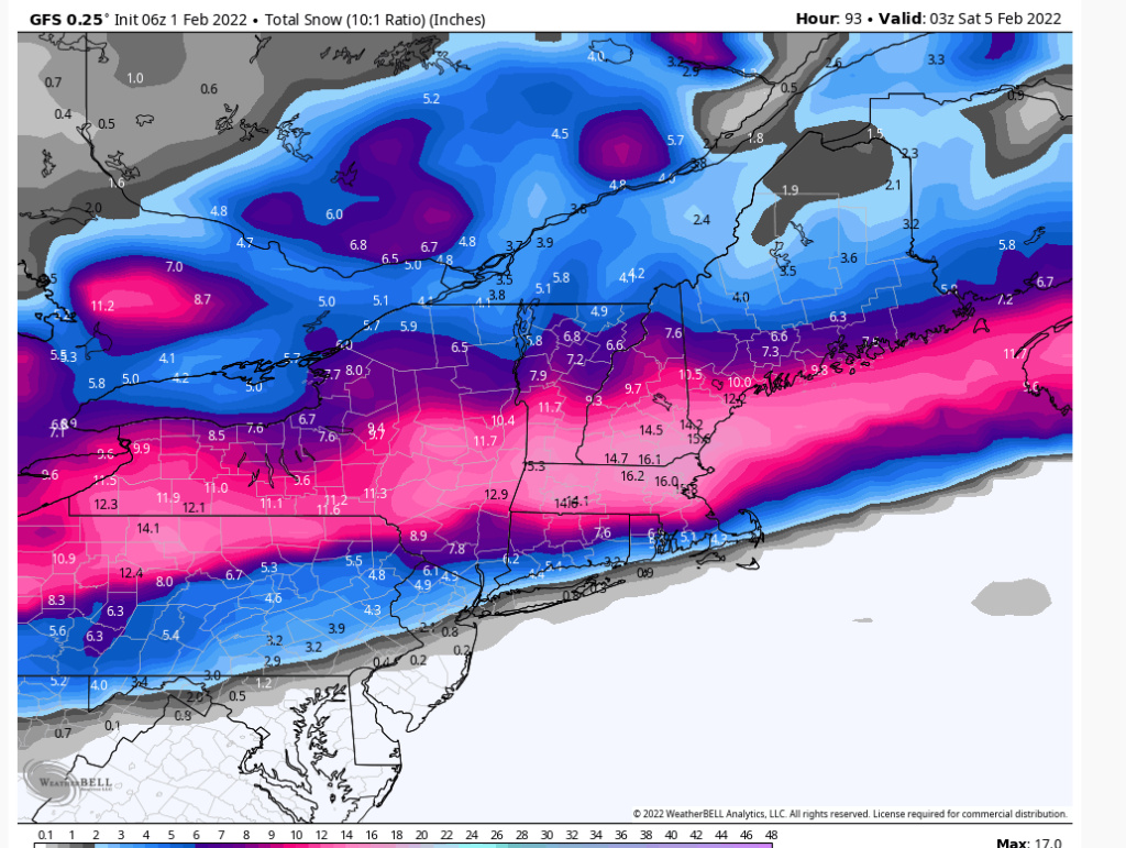
GFS is trending even colder for Friday’s storm
The High Pressure is actually in a similar position to the 18z run, but the cold press is a lot stronger.
The High Pressure is actually in a similar position to the 18z run, but the cold press is a lot stronger.
_________________
_______________________________________________________________________________________________________
CLICK HERE to view NJ Strong Snowstorm Classifications
 Re: Monitoring February 4th


_________________
_______________________________________________________________________________________________________
CLICK HERE to view NJ Strong Snowstorm Classifications
 Re: Monitoring February 4th
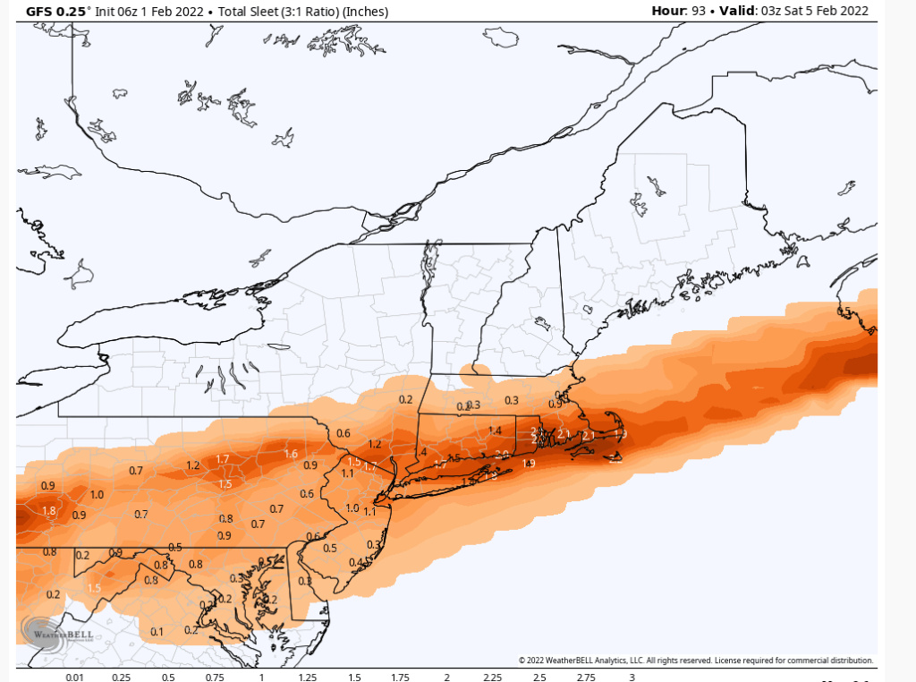
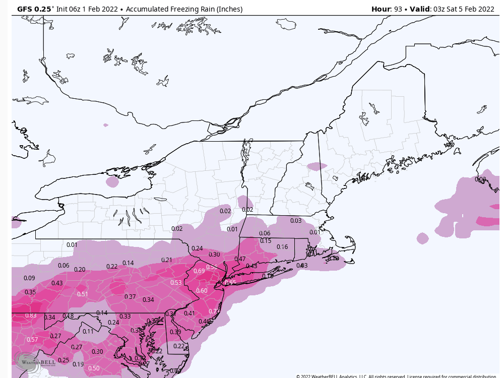
Based off of soundings the GFS for NYC showed:
*.50” rain
*.50” freezing rain
*2” sleet
*3” snow
Foggetaboutit
*.50” rain
*.50” freezing rain
*2” sleet
*3” snow
Foggetaboutit
_________________
_______________________________________________________________________________________________________
CLICK HERE to view NJ Strong Snowstorm Classifications
heehaw453- Advanced Forecaster

- Posts : 3906
Reputation : 86
Join date : 2014-01-20
Location : Bedminster Township, PA Elevation 600' ASL
 Re: Monitoring February 4th
EURO made a step again to GFS. That 1048 HP over OH CAnada is gonna drill the NE with cold dense arctic air. Just look at the source region and it tells you all you need to know.
1994, 1978, 1994 repeater.
Everyone wants winter weather, storms until it gets bad and then they want out.
1994, 1978, 1994 repeater.
Everyone wants winter weather, storms until it gets bad and then they want out.
_________________
Mugs
AKA:King: Snow Weenie
Self Proclaimed
WINTER 2014-15 : 55.12" +.02 for 6 coatings (avg. 35")
WINTER 2015-16 Total - 29.8" (Avg 35")
WINTER 2016-17 : 39.5" so far

amugs- Advanced Forecaster - Mod

- Posts : 15095
Reputation : 213
Join date : 2013-01-07
Age : 54
Location : Hillsdale,NJ
dkodgis likes this post
 Re: Monitoring February 4th
amugs wrote:EURO made a step again to GFS. That 1048 HP over OH CAnada is gonna drill the NE with cold dense arctic air. Just look at the source region and it tells you all you need to know.
1994, 1978, 1994 repeater.
Everyone wants winter weather, storms until it gets bad and then they want out.
Euro definitely making more of a move with stronger H and weaker L, but I think GFS cold, snow and ice numbers are too aggressive. 1/4" ice possibly down to I95 and off immediate coast threat on the table with some sleet on top of that. Snow 2-4" NW of I-95 and maybe C-1" on the 95.
heehaw453- Advanced Forecaster

- Posts : 3906
Reputation : 86
Join date : 2014-01-20
Location : Bedminster Township, PA Elevation 600' ASL
 Re: Monitoring February 4th
I'm in for whatever mother nature brings. We can't control if there's go b a ice storm but let's hope it snows. Or sleet is better than ice. The out p it's of frz are a but rediculous but we will see.amugs wrote:EURO made a step again to GFS. That 1048 HP over OH CAnada is gonna drill the NE with cold dense arctic air. Just look at the source region and it tells you all you need to know.
1994, 1978, 1994 repeater.
Everyone wants winter weather, storms until it gets bad and then they want out.

jmanley32- Senior Enthusiast

- Posts : 20535
Reputation : 108
Join date : 2013-12-12
Age : 43
Location : Yonkers, NY
mmanisca likes this post

jmanley32- Senior Enthusiast

- Posts : 20535
Reputation : 108
Join date : 2013-12-12
Age : 43
Location : Yonkers, NY
 Re: Monitoring February 4th
-2 degrees,clear calm wind.
Seeing the two words I hate for later in the week on NWS "wintry mix".Hoping for mostly snow or mostly rain.Weds and Thurs 40 or above here they say.
Seeing the two words I hate for later in the week on NWS "wintry mix".Hoping for mostly snow or mostly rain.Weds and Thurs 40 or above here they say.

docstox12- Wx Statistician Guru

- Posts : 8530
Reputation : 222
Join date : 2013-01-07
Age : 73
Location : Monroe NY
 Re: Monitoring February 4th
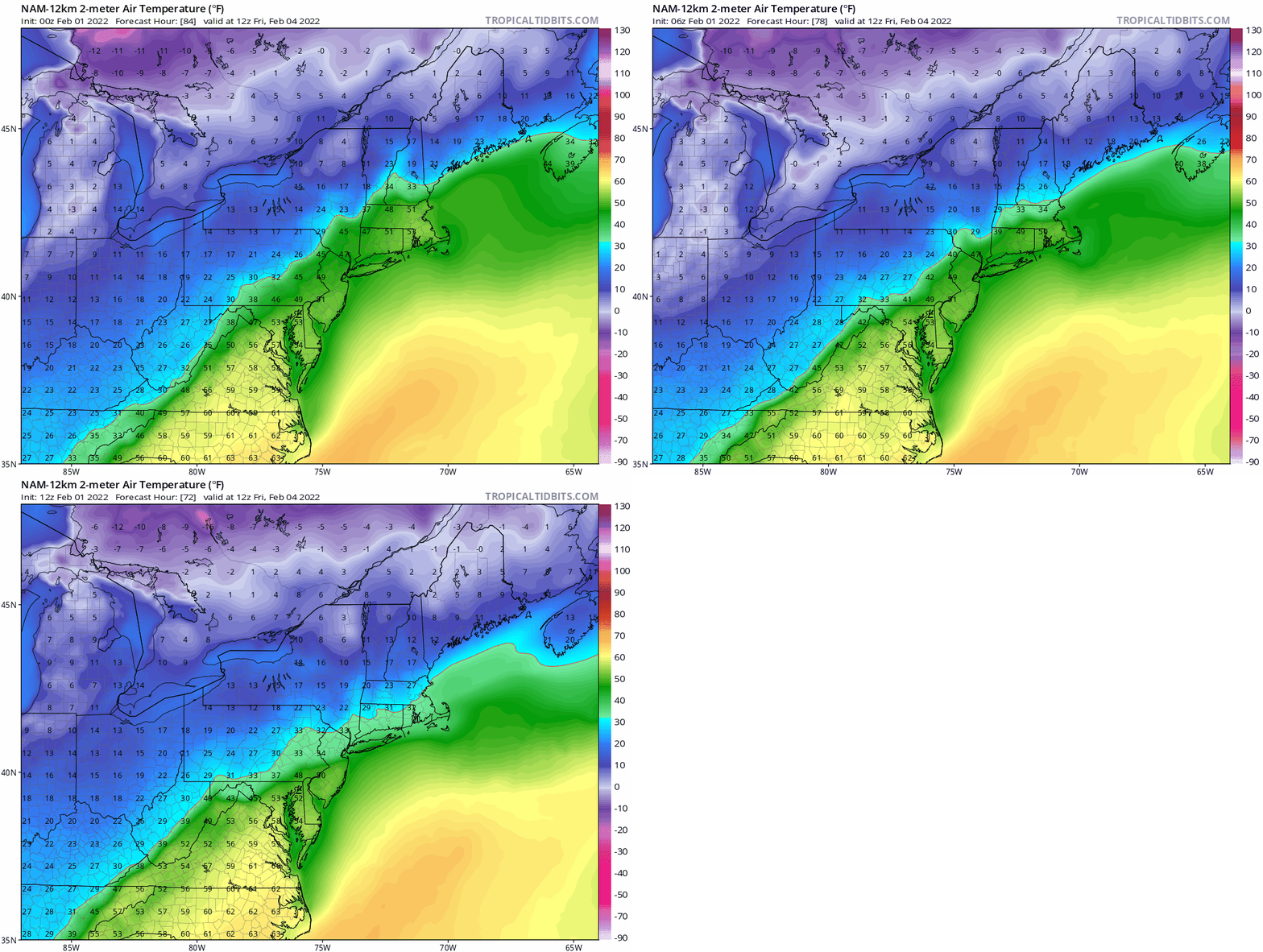
Winter storm watch is out for here. As for what's coming, it's a battle with the GFS and Euro (who are both calling for mostly,if not all snow)on one side and the NAM and CMC (who have it as mostly sleet)on the other. Normally, I'd assume the former is a lock, but again I seem to be within 50 miles of mix zone so neither side can be ruled out. Whatever happens out west, I hope the ice isn't as bad as they're calling for out your way.
TheAresian- Senior Enthusiast

- Posts : 145
Reputation : 10
Join date : 2019-11-13
Location : Painted Post, NY
 Re: Monitoring February 4th
Good morning crew! I have a Poconos trip planned this Wed. to Fri. Returning home back to CNJ Friday morning. In your opinion, could travel be treacherous? I’m thinking of postponing the trip. Any advice is appreciated!
richb521- Posts : 61
Reputation : 3
Join date : 2014-01-19
Age : 50
Location : Hillsborough, NJ
 Re: Monitoring February 4th
richb521 wrote:Good morning crew! I have a Poconos trip planned this Wed. to Fri. Returning home back to CNJ Friday morning. In your opinion, could travel be treacherous? I’m thinking of postponing the trip. Any advice is appreciated!
Friday morning will be a tough go in those mountains my man. Where about Rt80, 78? Those roads are treacherous during any winter storm in that region Rich. Bette to be safe from what is being shown by models. Give it another day if you can to see how things take shape.
_________________
Mugs
AKA:King: Snow Weenie
Self Proclaimed
WINTER 2014-15 : 55.12" +.02 for 6 coatings (avg. 35")
WINTER 2015-16 Total - 29.8" (Avg 35")
WINTER 2016-17 : 39.5" so far

amugs- Advanced Forecaster - Mod

- Posts : 15095
Reputation : 213
Join date : 2013-01-07
Age : 54
Location : Hillsdale,NJ
richb521 likes this post
 Re: Monitoring February 4th
Do you think this will be more like a sleet storm for me or a ice storm
frank 638- Senior Enthusiast

- Posts : 2843
Reputation : 37
Join date : 2016-01-01
Age : 40
Location : bronx ny
heehaw453- Advanced Forecaster

- Posts : 3906
Reputation : 86
Join date : 2014-01-20
Location : Bedminster Township, PA Elevation 600' ASL
 Re: Monitoring February 4th
No thanks on the ice. If it isn't going to be snow, I'll take 50* and rain.

billg315- Advanced Forecaster - Mod

- Posts : 4483
Reputation : 185
Join date : 2015-01-24
Age : 50
Location : Flemington, NJ
brownie, Sparky Sparticles and phil155 like this post
 Re: Monitoring February 4th
amugs wrote:richb521 wrote:Good morning crew! I have a Poconos trip planned this Wed. to Fri. Returning home back to CNJ Friday morning. In your opinion, could travel be treacherous? I’m thinking of postponing the trip. Any advice is appreciated!
Friday morning will be a tough go in those mountains my man. Where about Rt80, 78? Those roads are treacherous during any winter storm in that region Rich. Bette to be safe from what is being shown by models. Give it another day if you can to see how things take shape.
Thank you! Will probably postpone today to another time next month then. Normally the route I take is I-80 to I-78 via I-287 to home. Have to adjust work schedules today. Appreciate the advice!
richb521- Posts : 61
Reputation : 3
Join date : 2014-01-19
Age : 50
Location : Hillsborough, NJ
 Re: Monitoring February 4th
billg315 wrote:No thanks on the ice. If it isn't going to be snow, I'll take 50* and rain.
I think some ice is coming with this setup. I'm hoping 1/4" max which is much different than 1/2" w.r.t. impacts.
heehaw453- Advanced Forecaster

- Posts : 3906
Reputation : 86
Join date : 2014-01-20
Location : Bedminster Township, PA Elevation 600' ASL

SoulSingMG- Senior Enthusiast

- Posts : 2853
Reputation : 74
Join date : 2013-12-11
Location : Long Island City, NY
 Re: Monitoring February 4th
Wow, that's a huge shift south in one run!
Is this type of setup ripe for a significant amount of add'l southern suppression? I thought I've seen several times where a strong cold front that keeps pressing down from Canada from day 3-5 ends up marching south at a breakneck rate starting at about 3 days out and especially at 2 days out.
SENJsnowman- Senior Enthusiast

- Posts : 1189
Reputation : 61
Join date : 2017-01-06
Age : 51
Location : Bayville, NJ
amugs likes this post
Page 2 of 13 •  1, 2, 3, ... 11, 12, 13
Page 2 of 13
Permissions in this forum:
You cannot reply to topics in this forum|
|
|

 Home
Home


