Monitoring February 4th
+37
mmanisca
dkodgis
DAYBLAZER
Radz
crippo84
brownie
Math23x7
Grselig
essexcountypete
2004blackwrx
weatherwatchermom
RJB8525
freezerburn
sroc4
JT33
SNOW MAN
Dunnzoo
hyde345
jimv45
CPcantmeasuresnow
SENJsnowman
SoulSingMG
billg315
richb521
docstox12
aiannone
jmanley32
frank 638
TheAresian
MattyICE
mikeypizano
heehaw453
amugs
phil155
lglickman1
rb924119
Frank_Wx
41 posters
Page 3 of 13
Page 3 of 13 •  1, 2, 3, 4 ... 11, 12, 13
 Re: Monitoring February 4th
Wow, that's a huge shift south in one run!
Is this type of setup ripe for a significant amount of add'l southern suppression? I thought I've seen several times where a strong cold front that keeps pressing down from Canada from day 3-5 ends up marching south at a breakneck rate starting at about 3 days out and especially at 2 days out.
SENJsnowman- Senior Enthusiast

- Posts : 1189
Join date : 2017-01-06
amugs likes this post
 Re: Monitoring February 4th
frank 638 wrote:Do you think this will be more like a sleet storm for me or a ice storm
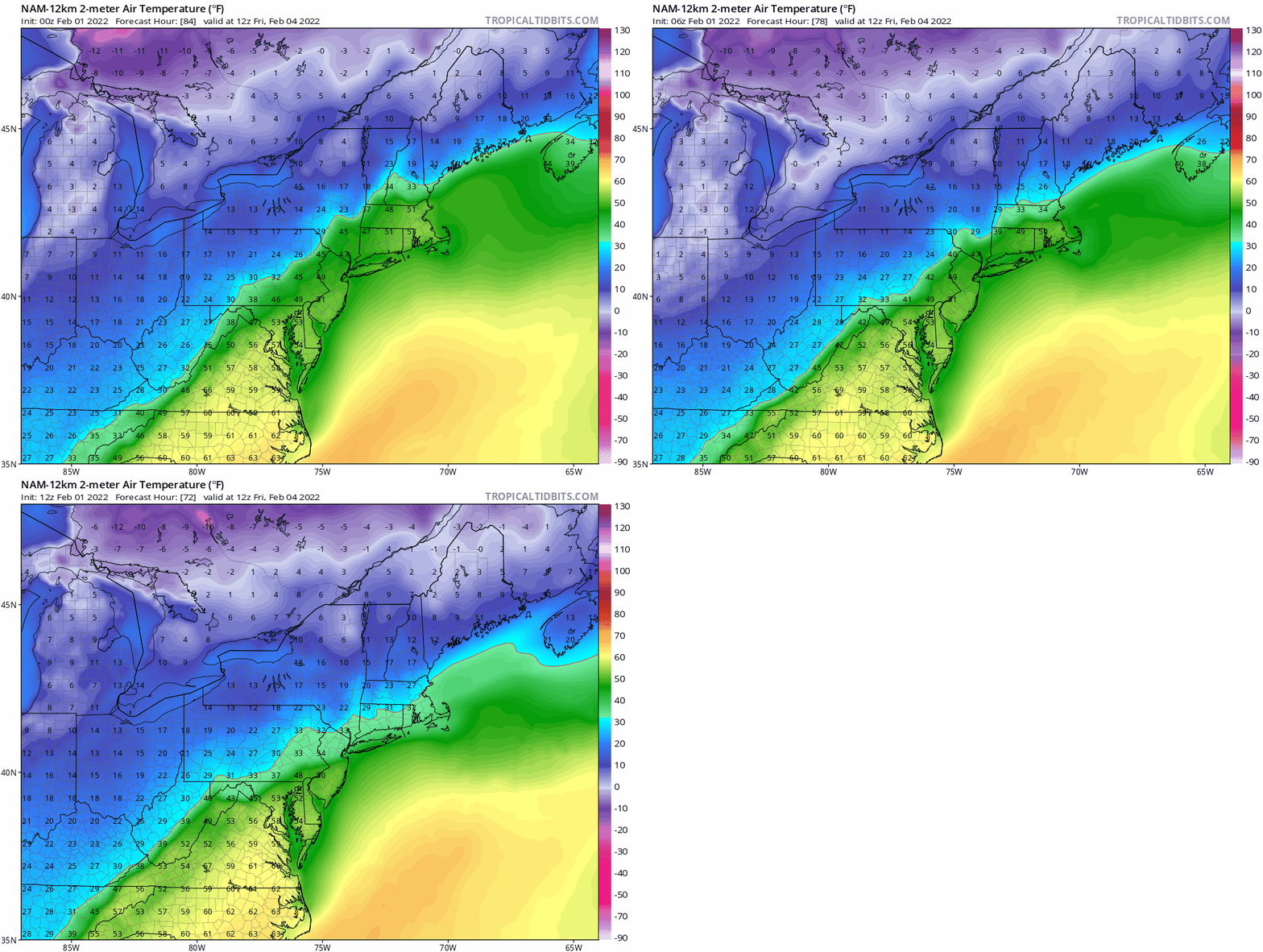
It all depends - NAM made a jump to the GFS.
This is a BIGLY ZR signal - sorry but we must recognize this possible scenario -
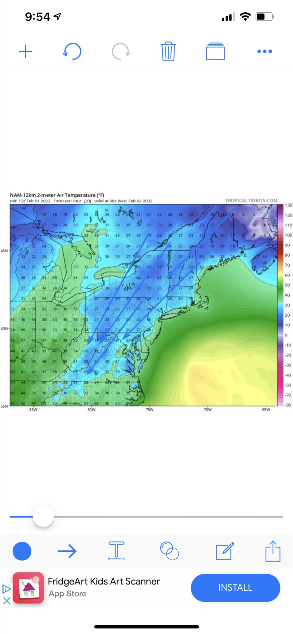
Look at the cold being driven sown - that's what I call drilling.
Need to use sounding for ZR. Snowfall maps are somewhat worthless with these types of storms
_________________
Mugs
AKA:King: Snow Weenie
Self Proclaimed
WINTER 2014-15 : 55.12" +.02 for 6 coatings (avg. 35")
WINTER 2015-16 Total - 29.8" (Avg 35")
WINTER 2016-17 : 39.5" so far

amugs- Advanced Forecaster - Mod

- Posts : 15095
Reputation : 213
Join date : 2013-01-07
Age : 54
Location : Hillsdale,NJ
 Re: Monitoring February 4th
NWS notes that it stalls, is this not going to be the case? I would think to get the totals shown we would need a stall.SENJsnowman wrote:
Wow, that's a huge shift south in one run!
Is this type of setup ripe for a significant amount of add'l southern suppression? I thought I've seen several times where a strong cold front that keeps pressing down from Canada from day 3-5 ends up marching south at a breakneck rate starting at about 3 days out and especially at 2 days out.

jmanley32- Senior Enthusiast

- Posts : 20535
Reputation : 108
Join date : 2013-12-12
Age : 43
Location : Yonkers, NY
 Re: Monitoring February 4th
_________________
-Alex Iannone-

aiannone- Senior Enthusiast - Mod

- Posts : 4815
Reputation : 92
Join date : 2013-01-07
Location : Saint James, LI (Northwest Suffolk Co.)
 Re: Monitoring February 4th
I plan to head to CT tonight or tomorrow and return Saturday midday, will I be good to do so? What time is this going to happen Friday if it does?

jmanley32- Senior Enthusiast

- Posts : 20535
Reputation : 108
Join date : 2013-12-12
Age : 43
Location : Yonkers, NY
 Re: Monitoring February 4th
There is not going to be much snow with this I'm fairly confident. 1/3-2/4 well NW of I95 as a mixture of snow/sleet. The issue will be the ice and how quickly the surface caves. The CAD will most easily flush low level cold closer to the surface. What I don't like is the CAD signature on this with strong banana high pressing down is a recipe for ice especially with snow OTG. Definitely starting to see a zone of sig ZR kind of like what Rb had said before. What you hope for your area is at least surface - 3000 feet above gets below freezing quickly to produce more sleet.
heehaw453- Advanced Forecaster

- Posts : 3906
Reputation : 86
Join date : 2014-01-20
Location : Bedminster Township, PA Elevation 600' ASL
rb924119 likes this post
 Re: Monitoring February 4th
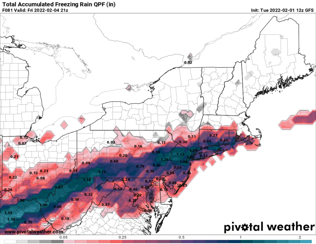
Well then, zoiks!! I find it very hard to believe that yonker's will be crushed by over a inch of frz but the GFS is not backing down and thats concerning even though last two storms it hasn't been great. Is there any other model support for this kind of ice accretion? Usually if NAM shows it it would be more concerning. But yeah disaster is to say the least massive power outages and impossible travel, in fact I would hope they would lock down travel period.

jmanley32- Senior Enthusiast

- Posts : 20535
Reputation : 108
Join date : 2013-12-12
Age : 43
Location : Yonkers, NY
 Re: Monitoring February 4th
Do you still feel the GFS is overdoing the frz or is it plausible that WCS could play out? Would not be first time but even cut those totals in half will still have major issues.heehaw453 wrote:There is not going to be much snow with this I'm fairly confident. 1/3-2/4 well NW of I95 as a mixture of snow/sleet. The issue will be the ice and how quickly the surface caves. The CAD will most easily flush low level cold closer to the surface. What I don't like is the CAD signature on this with strong banana high pressing down is a recipe for ice especially with snow OTG. Definitely starting to see a zone of sig ZR kind of like what Rb had said before. What you hope for your area is at least surface - 3000 feet above gets below freezing quickly to produce more sleet.

jmanley32- Senior Enthusiast

- Posts : 20535
Reputation : 108
Join date : 2013-12-12
Age : 43
Location : Yonkers, NY
 Re: Monitoring February 4th
jmanley32 wrote:Do you still feel the GFS is overdoing the frz or is it plausible that WCS could play out? Would not be first time but even cut those totals in half will still have major issues.heehaw453 wrote:There is not going to be much snow with this I'm fairly confident. 1/3-2/4 well NW of I95 as a mixture of snow/sleet. The issue will be the ice and how quickly the surface caves. The CAD will most easily flush low level cold closer to the surface. What I don't like is the CAD signature on this with strong banana high pressing down is a recipe for ice especially with snow OTG. Definitely starting to see a zone of sig ZR kind of like what Rb had said before. What you hope for your area is at least surface - 3000 feet above gets below freezing quickly to produce more sleet.
I think it's overdoing the scope, but I do think a zone where the conditions are just right could be in for 1/2" of ice accretion. And that will suck for that area.
heehaw453- Advanced Forecaster

- Posts : 3906
Reputation : 86
Join date : 2014-01-20
Location : Bedminster Township, PA Elevation 600' ASL
 Re: Monitoring February 4th
jmanley32 wrote:Do you still feel the GFS is overdoing the frz or is it plausible that WCS could play out? Would not be first time but even cut those totals in half will still have major issues.heehaw453 wrote:There is not going to be much snow with this I'm fairly confident. 1/3-2/4 well NW of I95 as a mixture of snow/sleet. The issue will be the ice and how quickly the surface caves. The CAD will most easily flush low level cold closer to the surface. What I don't like is the CAD signature on this with strong banana high pressing down is a recipe for ice especially with snow OTG. Definitely starting to see a zone of sig ZR kind of like what Rb had said before. What you hope for your area is at least surface - 3000 feet above gets below freezing quickly to produce more sleet.
Not that it won’t be impactful - that would be. But I’m pretty sure those numbers simply indicate the amount of QPF that falls AS freezing rain - not necessarily the amount of ice accretion. I think there will be .25” accretion common in some areas regardless of these numbers. Quite severe would be .5”.
MattyICE- Advanced Forecaster

- Posts : 249
Reputation : 6
Join date : 2017-11-10
Age : 38
Location : Clifton, NJ (Eastern Passaic County)
 Re: Monitoring February 4th
heehaw453 wrote:jmanley32 wrote:Do you still feel the GFS is overdoing the frz or is it plausible that WCS could play out? Would not be first time but even cut those totals in half will still have major issues.heehaw453 wrote:There is not going to be much snow with this I'm fairly confident. 1/3-2/4 well NW of I95 as a mixture of snow/sleet. The issue will be the ice and how quickly the surface caves. The CAD will most easily flush low level cold closer to the surface. What I don't like is the CAD signature on this with strong banana high pressing down is a recipe for ice especially with snow OTG. Definitely starting to see a zone of sig ZR kind of like what Rb had said before. What you hope for your area is at least surface - 3000 feet above gets below freezing quickly to produce more sleet.
I think it's overdoing the scope, but I do think a zone where the conditions are just right could be in for 1/2" of ice accretion. And that will suck for that area.
I think you are right, not all the rain that falls will freeze on contact there will certainly be a substantial portion of what falls that simply runs off especially if it falls heavily, much of it will not be able to build up on powerlines and branches but even if 40% of it does it would be really bad
phil155- Pro Enthusiast

- Posts : 483
Reputation : 4
Join date : 2019-12-16
 Re: Monitoring February 4th
makes sense, but wouldn't it be able to build up even if it fell hard if the temps were just right or does that matter? Yeah 0.25-0.5 is not good we had trees down a few years ago (not widespread but unfortunately my area was one of the unlucky ones) and it was not even 0.25, I will say looks beautiful but way to damaging to make it something to want to have happen, maybe a tiny glaze would be pretty. Also when it melts watch your head, I got pelted by ice falling from powerlines that last time. Only the actual weather know so the ice amount will likely be a nowcast wouldn't you agree? It would be nice to have that all fall as snow but that seems doubtful.phil155 wrote:heehaw453 wrote:jmanley32 wrote:Do you still feel the GFS is overdoing the frz or is it plausible that WCS could play out? Would not be first time but even cut those totals in half will still have major issues.heehaw453 wrote:There is not going to be much snow with this I'm fairly confident. 1/3-2/4 well NW of I95 as a mixture of snow/sleet. The issue will be the ice and how quickly the surface caves. The CAD will most easily flush low level cold closer to the surface. What I don't like is the CAD signature on this with strong banana high pressing down is a recipe for ice especially with snow OTG. Definitely starting to see a zone of sig ZR kind of like what Rb had said before. What you hope for your area is at least surface - 3000 feet above gets below freezing quickly to produce more sleet.
I think it's overdoing the scope, but I do think a zone where the conditions are just right could be in for 1/2" of ice accretion. And that will suck for that area.
I think you are right, not all the rain that falls will freeze on contact there will certainly be a substantial portion of what falls that simply runs off especially if it falls heavily, much of it will not be able to build up on powerlines and branches but even if 40% of it does it would be really bad

jmanley32- Senior Enthusiast

- Posts : 20535
Reputation : 108
Join date : 2013-12-12
Age : 43
Location : Yonkers, NY
 Re: Monitoring February 4th
The snowfall output GFS has been placing in the Beantown area are nonsense IMO.
heehaw453- Advanced Forecaster

- Posts : 3906
Reputation : 86
Join date : 2014-01-20
Location : Bedminster Township, PA Elevation 600' ASL
 Re: Monitoring February 4th
what does it show? They certainly jackpotted last week....not fair lolheehaw453 wrote:The snowfall output GFS has been placing in the Beantown area are nonsense IMO.

jmanley32- Senior Enthusiast

- Posts : 20535
Reputation : 108
Join date : 2013-12-12
Age : 43
Location : Yonkers, NY
 Re: Monitoring February 4th
The soundings on the GFS are not good at all for the NYC metro.
people think well if it less QPF it's better - dead wrong. Lighter precip will accumulate so much easier and faster than heavier precip. There is a warm layer in the black circled area.
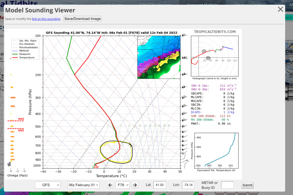
RGEM is colder by a bit too. Lets see what Mr Euro has to say.

CMC is warmer but gives some ZR and a flash freeze which could be worse??
people think well if it less QPF it's better - dead wrong. Lighter precip will accumulate so much easier and faster than heavier precip. There is a warm layer in the black circled area.

RGEM is colder by a bit too. Lets see what Mr Euro has to say.

CMC is warmer but gives some ZR and a flash freeze which could be worse??
_________________
Mugs
AKA:King: Snow Weenie
Self Proclaimed
WINTER 2014-15 : 55.12" +.02 for 6 coatings (avg. 35")
WINTER 2015-16 Total - 29.8" (Avg 35")
WINTER 2016-17 : 39.5" so far

amugs- Advanced Forecaster - Mod

- Posts : 15095
Reputation : 213
Join date : 2013-01-07
Age : 54
Location : Hillsdale,NJ
 Re: Monitoring February 4th
man per GFS if this were all snow be a area wide godzilla, what a waste. NYC proper 12z has 1.75 qpf, but 1.4 falls as rain or frz. rest I guess is snow or sleet.

jmanley32- Senior Enthusiast

- Posts : 20535
Reputation : 108
Join date : 2013-12-12
Age : 43
Location : Yonkers, NY
 Re: Monitoring February 4th
Food for thought from Earthlight at 33 n Rain:
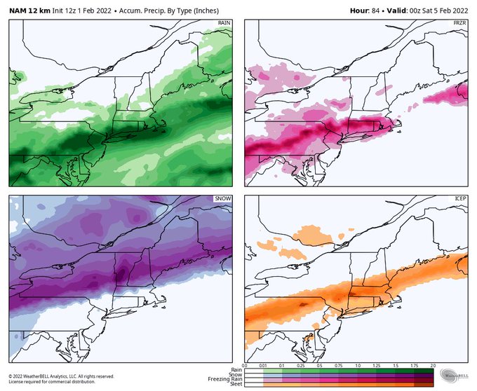
Completely agree and if one is going to use precip maps in a mixed event like this could be, IMO, one has to use three maps to get a sense of what's actually going to happen:
For pure snowfall, use the Pivotal snowfall map
For pure freezing rain accretion, use the Pivotal freezing rain map (understanding that that is converting all rain falling at <32F as accreting freezing rain, which is a worst case)
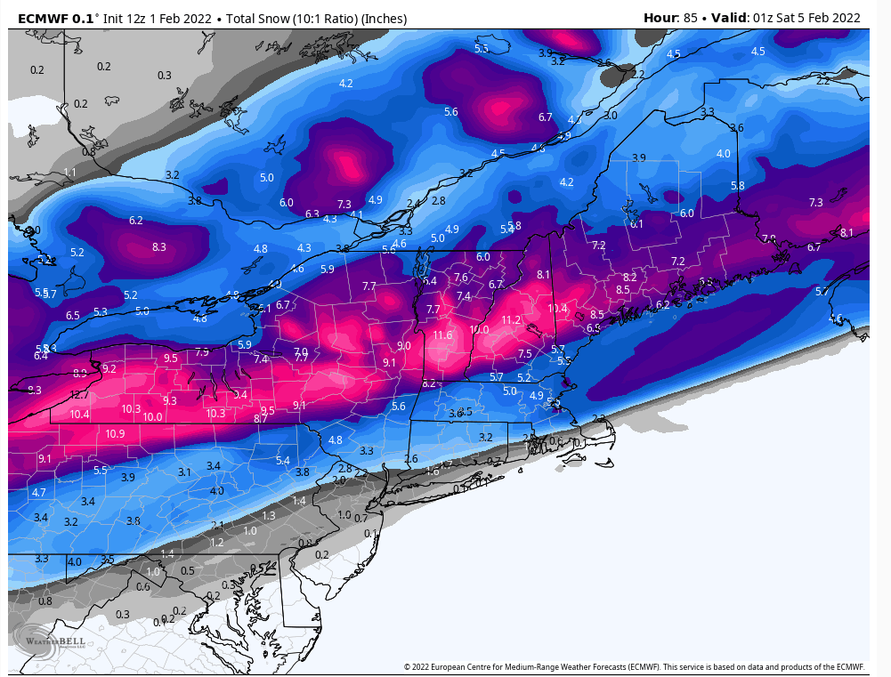
For sleet, take the Tidbits "snowfall" map (which includes sleet as 10:1 snow), and kind of manually subtract out the pure snowfall from Pivotal and then divide that resulting "snowfall" (sleet) by 3 to get the sleet accumulation (given the roughly 3:1 frozen/liquid ratio for sleet vs. 10:1 for snow). Actual sleet maps would be nice, since clearly that TT "snowfall" map is mostly sleet at a much lower ratio.
_________________
Mugs
AKA:King: Snow Weenie
Self Proclaimed
WINTER 2014-15 : 55.12" +.02 for 6 coatings (avg. 35")
WINTER 2015-16 Total - 29.8" (Avg 35")
WINTER 2016-17 : 39.5" so far

amugs- Advanced Forecaster - Mod

- Posts : 15095
Reputation : 213
Join date : 2013-01-07
Age : 54
Location : Hillsdale,NJ
 Re: Monitoring February 4th
He basically nailed the last few storms - will he be right?? But this is disconcerting
25-50 miles N of us gets smoked with snow IF it is true
12Z GFS TIGHTENS AREA OF FREEZING RAIN ON FRI AM.. I circled the area I am most concerned w/ Fri AM in the east. Not too concerned w/ NYC + south as ground temps are 29-31 but it's along and north of I80 where they go to 23 w/ deep warm layer aloft! pic.twitter.com/C9Uy7DqEGA
— Mike Masco (@MikeMasco) February 1, 2022
25-50 miles N of us gets smoked with snow IF it is true
_________________
Mugs
AKA:King: Snow Weenie
Self Proclaimed
WINTER 2014-15 : 55.12" +.02 for 6 coatings (avg. 35")
WINTER 2015-16 Total - 29.8" (Avg 35")
WINTER 2016-17 : 39.5" so far

amugs- Advanced Forecaster - Mod

- Posts : 15095
Reputation : 213
Join date : 2013-01-07
Age : 54
Location : Hillsdale,NJ
rb924119 likes this post
 Re: Monitoring February 4th
From NWS
remains close to the the current NBM. It should be noted that 00z
GFS is rather concerning given the amount of sleet/freezing rain
potential for Friday, but this seems to be an outlier of all the 00z
guidance. Because of this, have decided to stay away from this
solution. The 00z ECMWF, seems to have trended slightly cooler, but
not nearly as dramatic as the GFS. Its a trend that will need to be
monitored.
_________________
Mugs
AKA:King: Snow Weenie
Self Proclaimed
WINTER 2014-15 : 55.12" +.02 for 6 coatings (avg. 35")
WINTER 2015-16 Total - 29.8" (Avg 35")
WINTER 2016-17 : 39.5" so far

amugs- Advanced Forecaster - Mod

- Posts : 15095
Reputation : 213
Join date : 2013-01-07
Age : 54
Location : Hillsdale,NJ
lglickman1 likes this post
 Re: Monitoring February 4th
Holly MUCH more realistic
Mt. Holly AFD
.LONG TERM /THURSDAY THROUGH MONDAY/...
Summary...A couple of precipitation chances, winter weather
concerns, and very large temperature swings.
Synoptic Overview...An active pattern is expected for the end
of this week and into early next week. A long duration frontal
system is expected to affect our area Thursday and Friday, with
increased uncertainty regarding expected precipitation types. A
blast of arctic air is then expected for the weekend. Finally,
another storm tracking nearby early next week. There however
remains much to be determined regarding sensible weather
impacts.
For Thursday and Friday...A strong cold front to our northwest
will gradually move into the region during this time as a wave
of low pressure tracks along it. Ahead of the front, a much
milder air mass will move in as heights continue to rise and
surface winds remain southerly. Areas mainly along and
south/east of I-95 will climb into the 50s on Thursday. Gradual
rain development from northwest to southeast is expected as the
front slowly approaches, although much of the day may remain dry
south and east of I-95. We then watch the evolution of the
front as this will be critical to the arrival time of the cold
air. Model agreement is not great regarding the evolution of
this system, with the GFS charging the strong cold front faster
southeastward which results in a much colder solution and
therefore a significant snow and ice event for at least the
northern half of the region. However, other guidance remains
warmer with mainly rain with the exception for the very far
north as the low tracks just north of us. This would bring
another round of temperatures in the upper 40s and 50s on
Friday. The GFS has been consistent the past several runs in a
farther southward push of the front/cold air. The last few runs
of the ECMWF (including the new 00z run) has been shifting ever
so slightly southward though as well, so even though the GFS
seems to be a cold outlier it cannot be completely ruled out.
With a very strong arctic high to the north of this frontal
system and at least some lingering snowpack over parts of our
region, the setup is ripe for models to display some warm bias.
For now, we continued to indicate a changeover to a wintry mix
for at least parts of our northern and western zones.
Temperatures should start to fall during Friday afternoon as
strong cold air advection surges southeastward.
_________________
Mugs
AKA:King: Snow Weenie
Self Proclaimed
WINTER 2014-15 : 55.12" +.02 for 6 coatings (avg. 35")
WINTER 2015-16 Total - 29.8" (Avg 35")
WINTER 2016-17 : 39.5" so far

amugs- Advanced Forecaster - Mod

- Posts : 15095
Reputation : 213
Join date : 2013-01-07
Age : 54
Location : Hillsdale,NJ
 Re: Monitoring February 4th
amugs wrote:Holly MUCH more realistic
Mt. Holly AFD
.LONG TERM /THURSDAY THROUGH MONDAY/...
Summary...A couple of precipitation chances, winter weather
concerns, and very large temperature swings.
Synoptic Overview...An active pattern is expected for the end
of this week and into early next week. A long duration frontal
system is expected to affect our area Thursday and Friday, with
increased uncertainty regarding expected precipitation types. A
blast of arctic air is then expected for the weekend. Finally,
another storm tracking nearby early next week. There however
remains much to be determined regarding sensible weather
impacts.
For Thursday and Friday...A strong cold front to our northwest
will gradually move into the region during this time as a wave
of low pressure tracks along it. Ahead of the front, a much
milder air mass will move in as heights continue to rise and
surface winds remain southerly. Areas mainly along and
south/east of I-95 will climb into the 50s on Thursday. Gradual
rain development from northwest to southeast is expected as the
front slowly approaches, although much of the day may remain dry
south and east of I-95. We then watch the evolution of the
front as this will be critical to the arrival time of the cold
air. Model agreement is not great regarding the evolution of
this system, with the GFS charging the strong cold front faster
southeastward which results in a much colder solution and
therefore a significant snow and ice event for at least the
northern half of the region. However, other guidance remains
warmer with mainly rain with the exception for the very far
north as the low tracks just north of us. This would bring
another round of temperatures in the upper 40s and 50s on
Friday. The GFS has been consistent the past several runs in a
farther southward push of the front/cold air. The last few runs
of the ECMWF (including the new 00z run) has been shifting ever
so slightly southward though as well, so even though the GFS
seems to be a cold outlier it cannot be completely ruled out.
With a very strong arctic high to the north of this frontal
system and at least some lingering snowpack over parts of our
region, the setup is ripe for models to display some warm bias.
For now, we continued to indicate a changeover to a wintry mix
for at least parts of our northern and western zones.
Temperatures should start to fall during Friday afternoon as
strong cold air advection surges southeastward.
Someone is going to get iced with this setup and it's just a matter of where. The NAM IMO will fall inline by 00Z tonight with the icing threat.
heehaw453- Advanced Forecaster

- Posts : 3906
Reputation : 86
Join date : 2014-01-20
Location : Bedminster Township, PA Elevation 600' ASL
 Re: Monitoring February 4th
So an all snow scenario after some initial rain on Thursday is not in the cards for nyc metro?
lglickman1- Pro Enthusiast

- Posts : 319
Reputation : 0
Join date : 2013-02-05
Location : New Rochelle, NY
heehaw453- Advanced Forecaster

- Posts : 3906
Reputation : 86
Join date : 2014-01-20
Location : Bedminster Township, PA Elevation 600' ASL
amugs likes this post
 Re: Monitoring February 4th
Continuing to show a nice jackpot for the Aresian and the N and W frontiers.
I'm not sure why, but my weather forecasting instincts are telling me to expect more fairly strong suppression to the south.
I'm not sure why, but my weather forecasting instincts are telling me to expect more fairly strong suppression to the south.
SENJsnowman- Senior Enthusiast

- Posts : 1189
Reputation : 61
Join date : 2017-01-06
Age : 51
Location : Bayville, NJ
CPcantmeasuresnow likes this post
 Re: Monitoring February 4th
HOLY SHITSKIES PEEPS!!!
Caving mightily to the GFS - this storm will dictate Sunday/Monday storm - weaker it will eave behind energy that will follow up suite behind it

Great Map for Ice accretion- ZR


Look at that press - you do NOT underestimate the cold in the heart of winter with a deep snowpack in NE and Canada and a 1040 plus HP over Quebec with a 1040 to its WSW with -20's in Canada.
NWS is out to lunch in Upton...literally!
Caving mightily to the GFS - this storm will dictate Sunday/Monday storm - weaker it will eave behind energy that will follow up suite behind it

Great Map for Ice accretion- ZR


Look at that press - you do NOT underestimate the cold in the heart of winter with a deep snowpack in NE and Canada and a 1040 plus HP over Quebec with a 1040 to its WSW with -20's in Canada.
NWS is out to lunch in Upton...literally!
_________________
Mugs
AKA:King: Snow Weenie
Self Proclaimed
WINTER 2014-15 : 55.12" +.02 for 6 coatings (avg. 35")
WINTER 2015-16 Total - 29.8" (Avg 35")
WINTER 2016-17 : 39.5" so far

amugs- Advanced Forecaster - Mod

- Posts : 15095
Reputation : 213
Join date : 2013-01-07
Age : 54
Location : Hillsdale,NJ
heehaw453 likes this post
Page 3 of 13 •  1, 2, 3, 4 ... 11, 12, 13
Page 3 of 13
Permissions in this forum:
You cannot reply to topics in this forum|
|
|

 Home
Home
