Long Range Thread 25.0
+42
toople
Coachgriff
Carvin
Scullybutcher
Wheezer
lglickman1
dolphins222
Grselig
Zhukov1945
aiannone
CPcantmeasuresnow
jimv45
JT33
TheAresian
Radz
brownie
SENJsnowman
billg315
hyde345
SoulSingMG
Math23x7
phil155
snowbunny
mmanisca
Abba701
MattyICE
GreyBeard
nutleyblizzard
heehaw453
weatherwatchermom
HectorO
jmanley32
Irish
dkodgis
Dunnzoo
sroc4
algae888
Frank_Wx
kalleg
frank 638
docstox12
amugs
46 posters
Page 8 of 40
Page 8 of 40 •  1 ... 5 ... 7, 8, 9 ... 24 ... 40
heehaw453- Advanced Forecaster

- Posts : 3906
Join date : 2014-01-20
sroc4 and SoulSingMG like this post
 Re: Long Range Thread 25.0
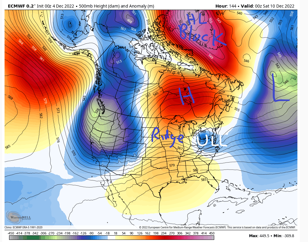
sroc4 wrote:heehaw453 wrote:The Euro depiction of 12/10 shows a very stout HP in Quebec pinned under HL blocking and another H starting to banana out. The ULL has no choice but to go underneath. The atmosphere gets plugged up when the HL blocking sets in. The AO supplying the cold air via the cold high pressure from the arctic. This is why I get excited with a good Atlantic/Arctic. It only takes a window for a ridge to pop to give us a chance. With progressive Atlantic patterns, i.e, w/out the Atlantic blocking you usually need more amplification much further west to have a chance and it's much more thread the needle.
I favor NW I95 for this due to antecedent air mass not being deeply cold. Euro and its EPS have been fairly consistent on this. It's still too far out to take too seriously but bears watching. Light to perhaps moderate potential IMO.
Hmmm. You make some great points here that causes an ear to go up for sure. That said I think there are a few things to point out that need to be over come.
First the air mass to our north really isn't arctic or even polar in its origin. Its more of a modified Pac air mass. By looking at the 500mb wind maps valid for hr 144, the same time stamp as the map you show above, that's the case.
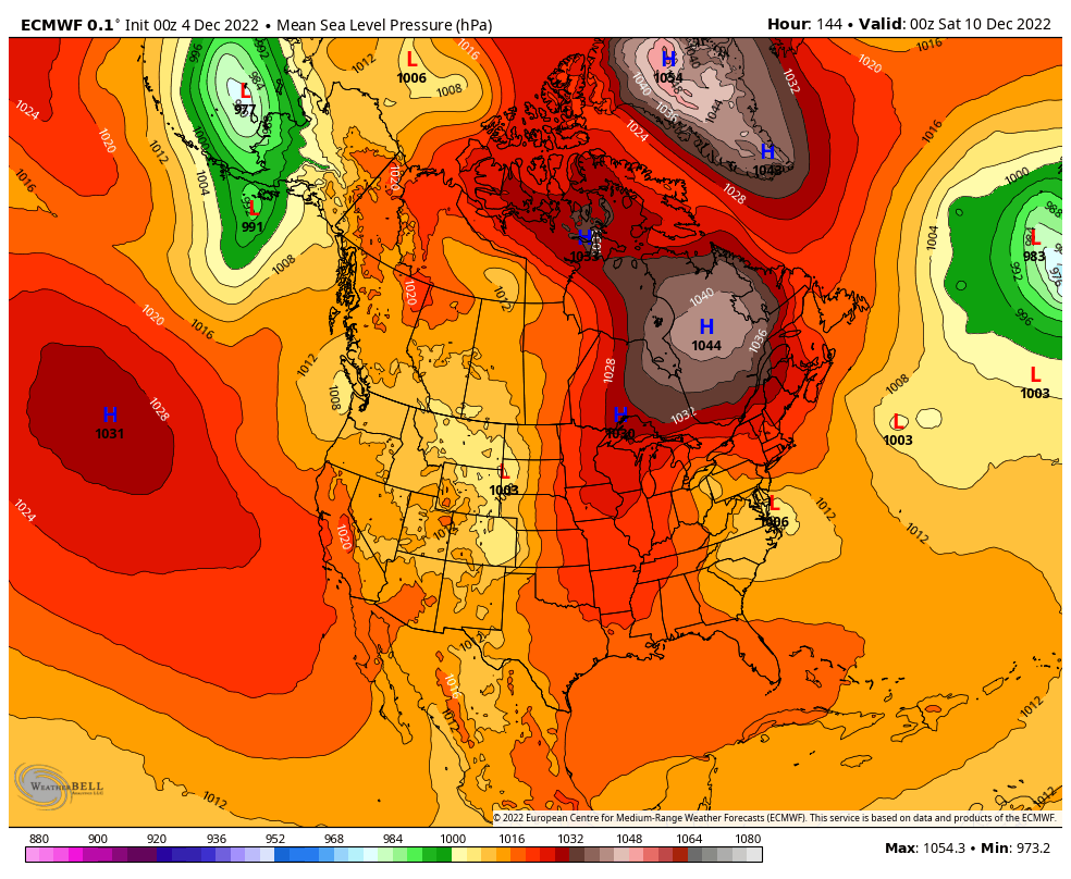
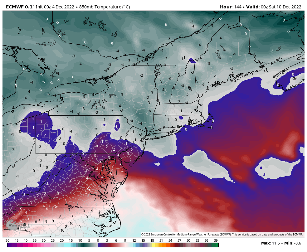
That said as you point out there is a stout (1044 verbatim)HP situated to our north, and a bottle neck in the N Atlantic complimentary of our -NAO. This should prevent that ULL and resulting slp from simply passing well to our west into the GL bringing the warm surge. Instead the result should force a transfer of the surface low pressure(slp) as it heads through the Ohio valley and NW Pa somewhere to our south off the Atlantic coast. As depicted verbatim by last nights 00z euro it develops right off the DelMarVa.
At first glance a developing slp off the Delmarva with a stout HP to the N is normally EXACTLY what we want to see. But the devil is in the details. If we zoom in a little on the MSLP map, see below, you see that the positioning of the HP is a bit too far east. This results in an E to ENE fetch.
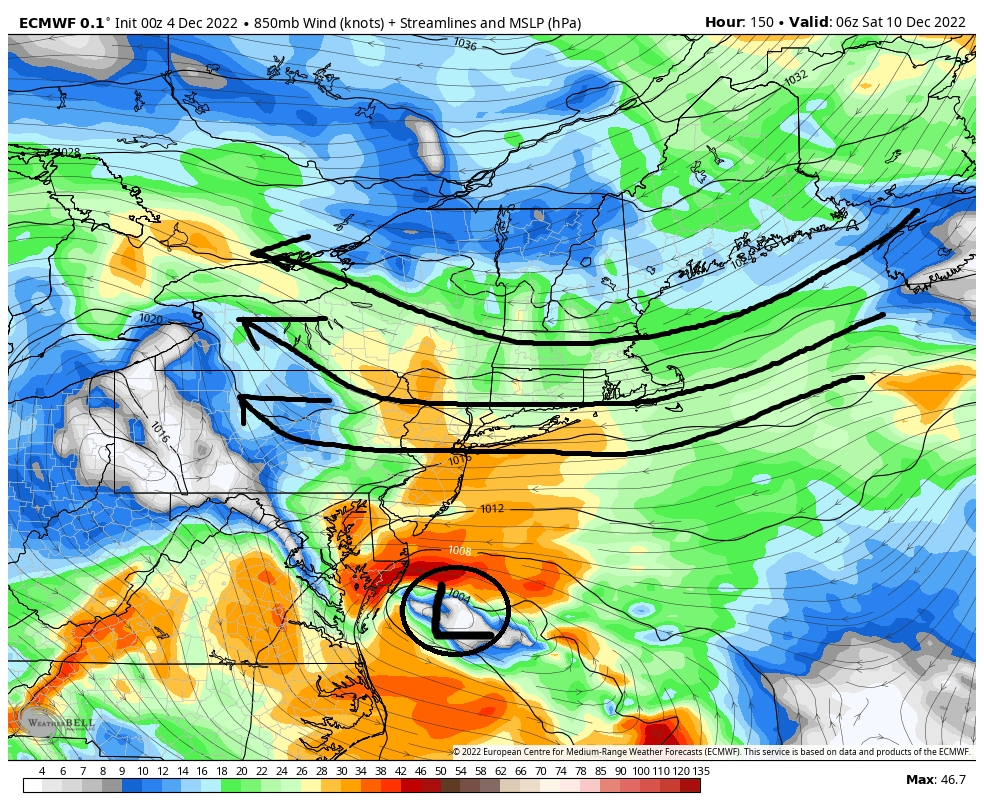
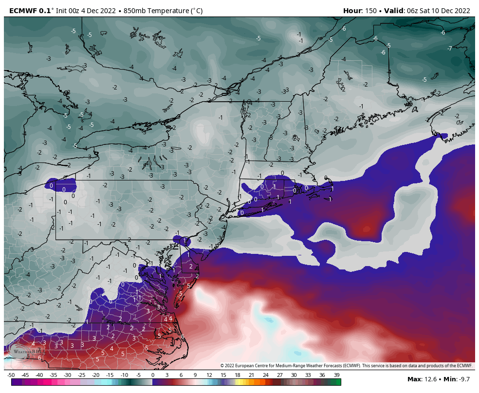
So again verbatim this will lead to our surface and mid levels to have wind directions coming off the ocean which is never a good thing. Again esp because our airmass to the north isn't arctic, it's modified pacific. First image shows the surface temps as the slp comes off the Delmarva, again hr 144. You can see there is a rather large contrast in temps along the coast vs just inland. Second image shows the 850mb winds. As you can see they are screaming in from the ENE. And third and fourth images are the 850 mb temps, hr 144 and the next frame hr 150, which shows how the mid levels warm to above freezing, esp along the coast, pretty quickly.
Now here is the thing. This far out still, 6days +/-, trying to read too much into the details of the temp profiles at the surface and mid levels, and the exact positioning of the HP and slp etc is futile as the upper level details are still evolving. As we all know we DO NOT need 20*F temps area wide for it to snow. All we need is "Cold Enough".
A simple shift of that HP north vs west vs east a tad, or how far north the primary slp gets before transferring vs an earlier transfer off the coast, and details of the outcome change dramatically. As you can plainly see the freezing line at 850 is right there. Heehaw as you stated above, areas N&W off the coast have a much higher chance at pulling some white out of this than does the coastal plain but no-one is out of the game just yet. That said a warmer soln for all is also on the table, as is the dreaded freezing rain solns for interior sections if those mid levels warm but the surface temps hold on below freezing which is def a possibly given the set up.
Its something to track for sure. Hopefully many more to come as well.
Remember the Friday sat threat? This could be the key to the Monday threat. This now modeled sheared out energyu could halp draw down just enough cold for the next wave to make a difference. There def is a threat here
sroc4- Admin

- Posts : 8331
Join date : 2013-01-07
kalleg, SoulSingMG and heehaw453 like this post
 Re: Long Range Thread 25.0
GFS has the Sunday night threat too. Robust system. The key seems to be how much cold air can be dragged in at the lower levels. The more the ULL digs the better the chances south of route 80. This is D4+ and there will be changes to this.
Notice the ridge pop and it's really not far off for coastal plain even on this run.

Notice the ridge pop and it's really not far off for coastal plain even on this run.

heehaw453- Advanced Forecaster

- Posts : 3906
Reputation : 86
Join date : 2014-01-20
Location : Bedminster Township, PA Elevation 600' ASL
phil155 likes this post
 Re: Long Range Thread 25.0
heehaw453 wrote:GFS has the Sunday night threat too. Robust system. The key seems to be how much cold air can be dragged in at the lower levels. The more the ULL digs the better the chances south of route 80. This is D4+ and there will be changes to this.
Notice the ridge pop and it's really not far off for coastal plain even on this run.
So your saying there is a chance.......
phil155- Pro Enthusiast

- Posts : 475
Reputation : 4
Join date : 2019-12-16
HectorO and heehaw453 like this post
 Re: Long Range Thread 25.0
heehaw453 wrote:GFS has the Sunday night threat too. Robust system. The key seems to be how much cold air can be dragged in at the lower levels. The more the ULL digs the better the chances south of route 80. This is D4+ and there will be changes to this.
Notice the ridge pop and it's really not far off for coastal plain even on this run.
Zoom out just a smidge. There is an ULL in the 50/50 region that on the GFS and CMC is retrograding complimentary of the clogged N Atlantic. This prevents the HP from slipping east like the friday/sat set up and the ENE fetch off the ocean. Temps throughout the mid levels are def much better with the second wave as a result because its more of a NNE direction.
_________________
"In weather and in life, there's no winning and losing; there's only winning and learning."
WINTER 2012/2013 TOTALS 43.65"WINTER 2017/2018 TOTALS 62.85" WINTER 2022/2023 TOTALS 4.9"
WINTER 2013/2014 TOTALS 64.85"WINTER 2018/2019 TOTALS 14.25" WINTER 2023/2024 TOTALS 13.1"
WINTER 2014/2015 TOTALS 71.20"WINTER 2019/2020 TOTALS 6.35"
WINTER 2015/2016 TOTALS 35.00"WINTER 2020/2021 TOTALS 37.75"
WINTER 2016/2017 TOTALS 42.25"WINTER 2021/2022 TOTALS 31.65"

sroc4- Admin

- Posts : 8331
Reputation : 301
Join date : 2013-01-07
Location : Wading River, LI
phil155 likes this post
 Re: Long Range Thread 25.0
sroc4 wrote:heehaw453 wrote:GFS has the Sunday night threat too. Robust system. The key seems to be how much cold air can be dragged in at the lower levels. The more the ULL digs the better the chances south of route 80. This is D4+ and there will be changes to this.
Notice the ridge pop and it's really not far off for coastal plain even on this run.
Zoom out just a smidge. There is an ULL in the 50/50 region that on the GFS and CMC is retrograding complimentary of the clogged N Atlantic. This prevents the HP from slipping east like the friday/sat set up and the ENE fetch off the ocean. Temps throughout the mid levels are def much better with the second wave as a result because its more of a NNE direction.
Canadian:
_________________
"In weather and in life, there's no winning and losing; there's only winning and learning."
WINTER 2012/2013 TOTALS 43.65"WINTER 2017/2018 TOTALS 62.85" WINTER 2022/2023 TOTALS 4.9"
WINTER 2013/2014 TOTALS 64.85"WINTER 2018/2019 TOTALS 14.25" WINTER 2023/2024 TOTALS 13.1"
WINTER 2014/2015 TOTALS 71.20"WINTER 2019/2020 TOTALS 6.35"
WINTER 2015/2016 TOTALS 35.00"WINTER 2020/2021 TOTALS 37.75"
WINTER 2016/2017 TOTALS 42.25"WINTER 2021/2022 TOTALS 31.65"

sroc4- Admin

- Posts : 8331
Reputation : 301
Join date : 2013-01-07
Location : Wading River, LI
 Re: Long Range Thread 25.0
^^^ Good call out sroc. The Atlantic blocking is definitely one key to keep things plugged up. I don't think the mid-levels are going to be an issue, but it's the lower levels that concern me in that it's not running into a good antecedent air mass. I believe for coastal plain to cash in there needs to a fast consolidation to flip the low levels wind direction. I like what the Euro has here on 00Z last night on the placement of the lower level low and if the antecedent air mass was good this would be much more straight forward. So I'm looking at this placement with faster consolidation to do the trick for coastal plain. Just tougher is all I'm saying.


heehaw453- Advanced Forecaster

- Posts : 3906
Reputation : 86
Join date : 2014-01-20
Location : Bedminster Township, PA Elevation 600' ASL
sroc4, SENJsnowman and phil155 like this post
 Re: Long Range Thread 25.0
This looks like a 2-4 inch type event mainly for the interior late this weekend. The CMC was bonkers 00z last night but came back to reality 12z. It still has me with 7-8 inches which I am not buying. Still a nice little event possible in early December. I'll take it.

hyde345- Pro Enthusiast

- Posts : 1082
Reputation : 48
Join date : 2013-01-08
Location : Hyde Park, NY
SENJsnowman likes this post
 Re: Long Range Thread 25.0
GFS was a nice hit rt 80 on northward. I would want to see the mid-level energy about 75-100 miles south of this to see immediate NYC area and NJ coastal plain have a shot at something substantial. Not looking at snow maps but this energy should ideally be coming across Cape May IMO. But based on the synoptic setup of this situation it very well may end up further south.


heehaw453- Advanced Forecaster

- Posts : 3906
Reputation : 86
Join date : 2014-01-20
Location : Bedminster Township, PA Elevation 600' ASL
 Re: Long Range Thread 25.0
As HeeHaw said, how much cold air can get it along with the precipitation. As an absolute layperson with weather, I checked ahead on my minor-league equipement (NWS, Alexa, and iPhone) and it seems it is going to be too warm. Of course I have no luck except bad luck so it may be cold enough, it may snow, it may be the start of the season.

dkodgis- Senior Enthusiast

- Posts : 2498
Reputation : 98
Join date : 2013-12-29
 Re: Long Range Thread 25.0
dkodgis wrote:As HeeHaw said, how much cold air can get it along with the precipitation. As an absolute layperson with weather, I checked ahead on my minor-league equipement (NWS, Alexa, and iPhone) and it seems it is going to be too warm. Of course I have no luck except bad luck so it may be cold enough, it may snow, it may be the start of the season.
You should do well with this one if you are in Orange county around 84. Don't you have elevation also? It may start as rain but I would suspect you will change to snow pretty quickly when intensity picks up.

hyde345- Pro Enthusiast

- Posts : 1082
Reputation : 48
Join date : 2013-01-08
Location : Hyde Park, NY
 Re: Long Range Thread 25.0
18z GFS verbatim has 6-12 for the NYC metro area and all surrounding but the bulls eye is literally right over me. Ha, I will believe it when I see it. One can dream, but it has just been to warm, I would think stickage even if it did snow would be hard.

jmanley32- Senior Enthusiast

- Posts : 20513
Reputation : 108
Join date : 2013-12-12
Age : 42
Location : Yonkers, NY
 Re: Long Range Thread 25.0
Hyde- yes. I am 3 miles NW of 84 (19B) so the Galleria Mall is close to me. Elevation is something like 700 ft. I am gushing hope

dkodgis- Senior Enthusiast

- Posts : 2498
Reputation : 98
Join date : 2013-12-29
 Re: Long Range Thread 25.0
as much I want snow it’s not going to happen!! Ur right it’s 55 deg to warm and mildjmanley32 wrote:18z GFS verbatim has 6-12 for the NYC metro area and all surrounding but the bulls eye is literally right over me. Ha, I will believe it when I see it. One can dream, but it has just been to warm, I would think stickage even if it did snow would be hard.
frank 638- Senior Enthusiast

- Posts : 2824
Reputation : 37
Join date : 2016-01-01
Age : 40
Location : bronx ny
 Re: Long Range Thread 25.0
frank 638 wrote:as much I want snow it’s not going to happen!! Ur right it’s 55 deg to warm and mildjmanley32 wrote:18z GFS verbatim has 6-12 for the NYC metro area and all surrounding but the bulls eye is literally right over me. Ha, I will believe it when I see it. One can dream, but it has just been to warm, I would think stickage even if it did snow would be hard.
Fellas fellas. Pump the breaks. First Jon. 6-12” IYBY? You’re 100% correct. Don’t believe it. It ain’t happening here. Keep the dream alive my brotha but keep it at that.
Make sure to keep your expectations realistic here. Remember 55today doesn’t mean 55 tomorrow. As has been stated in previous discussions because the west sucks upper Mongolian elk privates, the pattern we are in is one where we are looking for “cold enough”. For the coastal plain that might not be achievable on this one. It’s not out of the question yet because mid level temps look decent area wide, but realistically there is a good chance surface temps won’t allow snow. Or if it does snow there won’t me much if any accumulation because 1) surface temps are too warm and 2) because precip won’t fall hard enough.
We are now approximately 72-96hrs out from game time depending on where you live, and the hi res models will begin to hone in on the details. Keep in mind even the exact nature of the upper and mid level energy timing intensity and position is still pretty spread out with GFS most aggressive, euro least, and CMC in between. The soln…somewhere in between.
Some finer details that need sorting will be:
1) surface wind direction. It appears ahead of the redeveloping low there is an eastern fetch which is why areas along the coastal plain will struggle. Changes in low position, intensity etc can shift wind directions around and or increase/decrease intensity which could help or hinder depending on where you live and which direction it’s coming from.
2) because of the negative PNA and positive EPO there is no polar or arctic air mass around. Therefore the coastal plain especially will be in the upper 30’s and low 40’s come Sunday along the coastal plain. Areas NW with elevation will have a lower starting point for sure.
3) dew points: There are differences among models with dew points. Dew points below freezing that get under a decent band of precip, even if above freezing at the surface, with mid levels plenty cold evaporative/dynamic cooling could easily allow for rapid cooling and snow fall. Accumulation? That would depend on intensity. Don’t expect anywhere near 10:1 ratio even if it does snow and you live along the coastal plain.
Again finer details like how strong and organized is the uppers level energy and where will determine where our low pops. Where is starts and where it ends will dictate wind directions and thus sort out temp profiles etc. With still pretty significant details in the upper levels among models no one should get too worked up over any solns just yet.
Keep the expectation’s in check. Coastal plain. Raise the bar only as high as…if I see snow falling and maybe get an inch or two….Cha Ching. If it only rains…well it really wasn’t that unexpected given the set up. N&W. Anything less than a couple of inches and I’d be disappointed. With 3-6” being my ceiling…for now
Let’s see what the next 24-36 hrs brings from the hi res models. Maybe expectations can be recalibrated by the weekend…for better OR worse.
We Track!!!!

_________________
"In weather and in life, there's no winning and losing; there's only winning and learning."
WINTER 2012/2013 TOTALS 43.65"WINTER 2017/2018 TOTALS 62.85" WINTER 2022/2023 TOTALS 4.9"
WINTER 2013/2014 TOTALS 64.85"WINTER 2018/2019 TOTALS 14.25" WINTER 2023/2024 TOTALS 13.1"
WINTER 2014/2015 TOTALS 71.20"WINTER 2019/2020 TOTALS 6.35"
WINTER 2015/2016 TOTALS 35.00"WINTER 2020/2021 TOTALS 37.75"
WINTER 2016/2017 TOTALS 42.25"WINTER 2021/2022 TOTALS 31.65"

sroc4- Admin

- Posts : 8331
Reputation : 301
Join date : 2013-01-07
Location : Wading River, LI
kalleg, SoulSingMG, heehaw453 and Wheezer like this post
 Re: Long Range Thread 25.0
I hope everyone is ready between sometime tonight and Saturday morning for the first crazy NAM run of the season! You all know it’s coming. And know it’ll go away the next run. But it wouldn’t be tracking season without that  Kidding aside, it WILL be interesting to see how the Meso/short range models handle this.
MattyICE- Advanced Forecaster

- Posts : 249
Reputation : 6
Join date : 2017-11-10
Age : 38
Location : Clifton, NJ (Eastern Passaic County)
sroc4, kalleg and heehaw453 like this post
 Re: Long Range Thread 25.0
MattyICE wrote:I hope everyone is ready between sometime tonight and Saturday morning for the first crazy NAM run of the season! You all know it’s coming. And know it’ll go away the next run. But it wouldn’t be tracking season without thatKidding aside, it WILL be interesting to see how the Meso/short range models handle this.
Weenie run of at least one NAM 12+" has to show up
_________________
"In weather and in life, there's no winning and losing; there's only winning and learning."
WINTER 2012/2013 TOTALS 43.65"WINTER 2017/2018 TOTALS 62.85" WINTER 2022/2023 TOTALS 4.9"
WINTER 2013/2014 TOTALS 64.85"WINTER 2018/2019 TOTALS 14.25" WINTER 2023/2024 TOTALS 13.1"
WINTER 2014/2015 TOTALS 71.20"WINTER 2019/2020 TOTALS 6.35"
WINTER 2015/2016 TOTALS 35.00"WINTER 2020/2021 TOTALS 37.75"
WINTER 2016/2017 TOTALS 42.25"WINTER 2021/2022 TOTALS 31.65"

sroc4- Admin

- Posts : 8331
Reputation : 301
Join date : 2013-01-07
Location : Wading River, LI
MattyICE likes this post
 Re: Long Range Thread 25.0
not expecting much at all from this system, I will be happy with some mood flakes here in middlesex county nj
phil155- Pro Enthusiast

- Posts : 475
Reputation : 4
Join date : 2019-12-16
heehaw453 likes this post
 Re: Long Range Thread 25.0
phil155 wrote:not expecting much at all from this system, I will be happy with some mood flakes here in middlesex county nj
I agree. I think it’ll be fun to track for a few days but if I had to guess - anywhere away from
The coast could get a few inches - but closer likely mostly white rain. Some nice mood flakes that don’t accumulate a ton. But these inverted trough set ups can come with some fun surprises.
MattyICE- Advanced Forecaster

- Posts : 249
Reputation : 6
Join date : 2017-11-10
Age : 38
Location : Clifton, NJ (Eastern Passaic County)
 Re: Long Range Thread 25.0
Not saying anything is definite, but I could see this thing somewhat trend like the way the system that was supposed to come through tonight into tomorrow did. That is instead of the upper level energy closing off and developing an intensifying Low and worrying about the where and when there; instead nthe upper level energy trends towards the sheared out vorticity with less and less QPF because there is no trigger for lift. Well see.
_________________
"In weather and in life, there's no winning and losing; there's only winning and learning."
WINTER 2012/2013 TOTALS 43.65"WINTER 2017/2018 TOTALS 62.85" WINTER 2022/2023 TOTALS 4.9"
WINTER 2013/2014 TOTALS 64.85"WINTER 2018/2019 TOTALS 14.25" WINTER 2023/2024 TOTALS 13.1"
WINTER 2014/2015 TOTALS 71.20"WINTER 2019/2020 TOTALS 6.35"
WINTER 2015/2016 TOTALS 35.00"WINTER 2020/2021 TOTALS 37.75"
WINTER 2016/2017 TOTALS 42.25"WINTER 2021/2022 TOTALS 31.65"

sroc4- Admin

- Posts : 8331
Reputation : 301
Join date : 2013-01-07
Location : Wading River, LI
MattyICE likes this post
heehaw453- Advanced Forecaster

- Posts : 3906
Reputation : 86
Join date : 2014-01-20
Location : Bedminster Township, PA Elevation 600' ASL
 Re: Long Range Thread 25.0
_________________
Mugs
AKA:King: Snow Weenie
Self Proclaimed
WINTER 2014-15 : 55.12" +.02 for 6 coatings (avg. 35")
WINTER 2015-16 Total - 29.8" (Avg 35")
WINTER 2016-17 : 39.5" so far

amugs- Advanced Forecaster - Mod

- Posts : 15093
Reputation : 213
Join date : 2013-01-07
Age : 54
Location : Hillsdale,NJ
 Re: Long Range Thread 25.0
Did I not say all that you just said back to me Scott in my post? I know it is not going to happen and am fine with that. Nowadays I do not look forward to snow until January. For all I know it may be 75 on xmas eve again. maybe I read it wrong but it came across sarcastic.sroc4 wrote:frank 638 wrote:as much I want snow it’s not going to happen!! Ur right it’s 55 deg to warm and mildjmanley32 wrote:18z GFS verbatim has 6-12 for the NYC metro area and all surrounding but the bulls eye is literally right over me. Ha, I will believe it when I see it. One can dream, but it has just been to warm, I would think stickage even if it did snow would be hard.
Fellas fellas. Pump the breaks. First Jon. 6-12” IYBY? You’re 100% correct. Don’t believe it. It ain’t happening here. Keep the dream alive my brotha but keep it at that.
Make sure to keep your expectations realistic here. Remember 55today doesn’t mean 55 tomorrow. As has been stated in previous discussions because the west sucks upper Mongolian elk privates, the pattern we are in is one where we are looking for “cold enough”. For the coastal plain that might not be achievable on this one. It’s not out of the question yet because mid level temps look decent area wide, but realistically there is a good chance surface temps won’t allow snow. Or if it does snow there won’t me much if any accumulation because 1) surface temps are too warm and 2) because precip won’t fall hard enough.
We are now approximately 72-96hrs out from game time depending on where you live, and the hi res models will begin to hone in on the details. Keep in mind even the exact nature of the upper and mid level energy timing intensity and position is still pretty spread out with GFS most aggressive, euro least, and CMC in between. The soln…somewhere in between.
Some finer details that need sorting will be:
1) surface wind direction. It appears ahead of the redeveloping low there is an eastern fetch which is why areas along the coastal plain will struggle. Changes in low position, intensity etc can shift wind directions around and or increase/decrease intensity which could help or hinder depending on where you live and which direction it’s coming from.
2) because of the negative PNA and positive EPO there is no polar or arctic air mass around. Therefore the coastal plain especially will be in the upper 30’s and low 40’s come Sunday along the coastal plain. Areas NW with elevation will have a lower starting point for sure.
3) dew points: There are differences among models with dew points. Dew points below freezing that get under a decent band of precip, even if above freezing at the surface, with mid levels plenty cold evaporative/dynamic cooling could easily allow for rapid cooling and snow fall. Accumulation? That would depend on intensity. Don’t expect anywhere near 10:1 ratio even if it does snow and you live along the coastal plain.
Again finer details like how strong and organized is the uppers level energy and where will determine where our low pops. Where is starts and where it ends will dictate wind directions and thus sort out temp profiles etc. With still pretty significant details in the upper levels among models no one should get too worked up over any solns just yet.
Keep the expectation’s in check. Coastal plain. Raise the bar only as high as…if I see snow falling and maybe get an inch or two….Cha Ching. If it only rains…well it really wasn’t that unexpected given the set up. N&W. Anything less than a couple of inches and I’d be disappointed. With 3-6” being my ceiling…for now
Let’s see what the next 24-36 hrs brings from the hi res models. Maybe expectations can be recalibrated by the weekend…for better OR worse.
We Track!!!!

jmanley32- Senior Enthusiast

- Posts : 20513
Reputation : 108
Join date : 2013-12-12
Age : 42
Location : Yonkers, NY
 Re: Long Range Thread 25.0
jmanley32 wrote:Did I not say all that you just said back to me Scott in my post? I know it is not going to happen and am fine with that. Nowadays I do not look forward to snow until January. For all I know it may be 75 on xmas eve again. maybe I read it wrong but it came across sarcastic.sroc4 wrote:frank 638 wrote:as much I want snow it’s not going to happen!! Ur right it’s 55 deg to warm and mildjmanley32 wrote:18z GFS verbatim has 6-12 for the NYC metro area and all surrounding but the bulls eye is literally right over me. Ha, I will believe it when I see it. One can dream, but it has just been to warm, I would think stickage even if it did snow would be hard.
Fellas fellas. Pump the breaks. First Jon. 6-12” IYBY? You’re 100% correct. Don’t believe it. It ain’t happening here. Keep the dream alive my brotha but keep it at that.
Make sure to keep your expectations realistic here. Remember 55today doesn’t mean 55 tomorrow. As has been stated in previous discussions because the west sucks upper Mongolian elk privates, the pattern we are in is one where we are looking for “cold enough”. For the coastal plain that might not be achievable on this one. It’s not out of the question yet because mid level temps look decent area wide, but realistically there is a good chance surface temps won’t allow snow. Or if it does snow there won’t me much if any accumulation because 1) surface temps are too warm and 2) because precip won’t fall hard enough.
We are now approximately 72-96hrs out from game time depending on where you live, and the hi res models will begin to hone in on the details. Keep in mind even the exact nature of the upper and mid level energy timing intensity and position is still pretty spread out with GFS most aggressive, euro least, and CMC in between. The soln…somewhere in between.
Some finer details that need sorting will be:
1) surface wind direction. It appears ahead of the redeveloping low there is an eastern fetch which is why areas along the coastal plain will struggle. Changes in low position, intensity etc can shift wind directions around and or increase/decrease intensity which could help or hinder depending on where you live and which direction it’s coming from.
2) because of the negative PNA and positive EPO there is no polar or arctic air mass around. Therefore the coastal plain especially will be in the upper 30’s and low 40’s come Sunday along the coastal plain. Areas NW with elevation will have a lower starting point for sure.
3) dew points: There are differences among models with dew points. Dew points below freezing that get under a decent band of precip, even if above freezing at the surface, with mid levels plenty cold evaporative/dynamic cooling could easily allow for rapid cooling and snow fall. Accumulation? That would depend on intensity. Don’t expect anywhere near 10:1 ratio even if it does snow and you live along the coastal plain.
Again finer details like how strong and organized is the uppers level energy and where will determine where our low pops. Where is starts and where it ends will dictate wind directions and thus sort out temp profiles etc. With still pretty significant details in the upper levels among models no one should get too worked up over any solns just yet.
Keep the expectation’s in check. Coastal plain. Raise the bar only as high as…if I see snow falling and maybe get an inch or two….Cha Ching. If it only rains…well it really wasn’t that unexpected given the set up. N&W. Anything less than a couple of inches and I’d be disappointed. With 3-6” being my ceiling…for now
Let’s see what the next 24-36 hrs brings from the hi res models. Maybe expectations can be recalibrated by the weekend…for better OR worse.
We Track!!!!
You definitely read it wrong. Wasn't sarcastic, more lighthearted.

Irish- Pro Enthusiast

- Posts : 788
Reputation : 19
Join date : 2019-01-16
Age : 45
Location : Old Bridge, NJ
sroc4 and jmanley32 like this post
 Re: Long Range Thread 25.0
_________________
Mugs
AKA:King: Snow Weenie
Self Proclaimed
WINTER 2014-15 : 55.12" +.02 for 6 coatings (avg. 35")
WINTER 2015-16 Total - 29.8" (Avg 35")
WINTER 2016-17 : 39.5" so far

amugs- Advanced Forecaster - Mod

- Posts : 15093
Reputation : 213
Join date : 2013-01-07
Age : 54
Location : Hillsdale,NJ
heehaw453, SENJsnowman, MattyICE and Irish like this post
 Re: Long Range Thread 25.0
The 12/9 0Z 12 km NAM for Sunday gives a couple of inches of snow for me here in Albany with higher amounts to my south and west in the Catskills.
Keep in mind that with the strong -PNA, systems that come this way have a better chance of giving snow to the interior northeast than to the I-95 corridor. Also keep in mind that there is a cutoff where the precipitation will fizzle out as indicated by hr 84, so I would like to see if the location of the snow band holds.
Though in my case, given the pattern, I would these amounts shown and run with them.

Math23x7- Wx Statistician Guru

- Posts : 2379
Reputation : 68
Join date : 2013-01-08
 Re: Long Range Thread 25.0
If I can see some flakes I would be pleased with that for this time of year and with the mild temps we have had.

jmanley32- Senior Enthusiast

- Posts : 20513
Reputation : 108
Join date : 2013-12-12
Age : 42
Location : Yonkers, NY
Page 8 of 40 •  1 ... 5 ... 7, 8, 9 ... 24 ... 40
Page 8 of 40
Permissions in this forum:
You cannot reply to topics in this forum|
|
|

 Home
Home