November Obs & Discussions
Page 5 of 7 •  1, 2, 3, 4, 5, 6, 7
 Re: November Obs & Discussions
Radz- Pro Enthusiast

- Posts : 1028
Join date : 2013-01-12
 Re: November Obs & Discussions
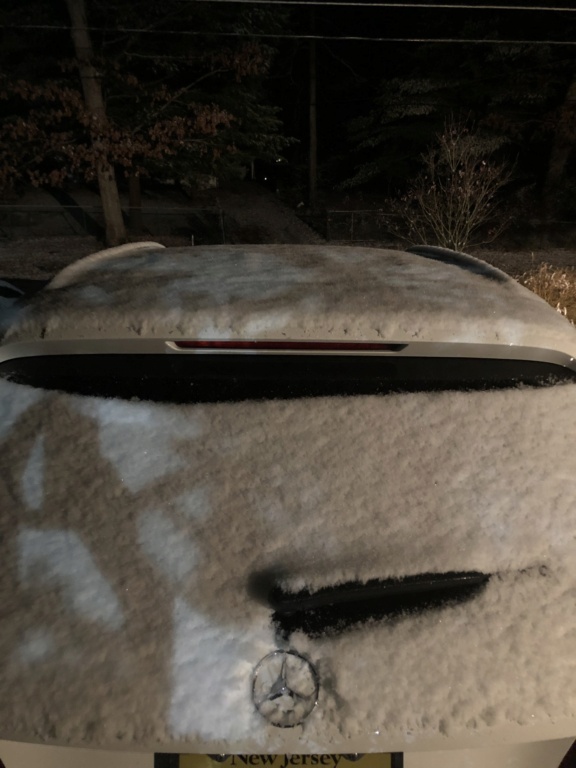
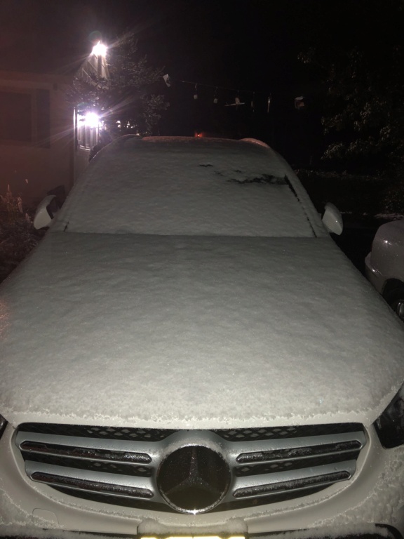
30 degrees. About two inches

dkodgis- Senior Enthusiast

- Posts : 2663
Reputation : 98
Join date : 2013-12-29
weatherwatchermom likes this post
 Re: November Obs & Discussions
_________________
Mugs
AKA:King: Snow Weenie
Self Proclaimed
WINTER 2014-15 : 55.12" +.02 for 6 coatings (avg. 35")
WINTER 2015-16 Total - 29.8" (Avg 35")
WINTER 2016-17 : 39.5" so far

amugs- Advanced Forecaster - Mod

- Posts : 15130
Reputation : 213
Join date : 2013-01-07
Age : 54
Location : Hillsdale,NJ
 Re: November Obs & Discussions
This is just magnificent!! Live CAM of the Adirondacks snowfall. Natures beauty!
https://www.camp-of-the-woods.org/camp-cam
_________________
Mugs
AKA:King: Snow Weenie
Self Proclaimed
WINTER 2014-15 : 55.12" +.02 for 6 coatings (avg. 35")
WINTER 2015-16 Total - 29.8" (Avg 35")
WINTER 2016-17 : 39.5" so far

amugs- Advanced Forecaster - Mod

- Posts : 15130
Reputation : 213
Join date : 2013-01-07
Age : 54
Location : Hillsdale,NJ
weatherwatchermom likes this post
 Re: November Obs & Discussions
_________________
_______________________________________________________________________________________________________
CLICK HERE to view NJ Strong Snowstorm Classifications
 Re: November Obs & Discussions

jmanley32- Senior Enthusiast

- Posts : 20635
Reputation : 108
Join date : 2013-12-12
Age : 43
Location : Yonkers, NY
 Re: November Obs & Discussions
_________________
Janet
Snowfall winter of 2023-2024 17.5"
Snowfall winter of 2022-2023 6.0"
Snowfall winter of 2021-2022 17.6" 1" sleet 2/25/22
Snowfall winter of 2020-2021 51.1"
Snowfall winter of 2019-2020 8.5"
Snowfall winter of 2018-2019 25.1"
Snowfall winter of 2017-2018 51.9"
Snowfall winter of 2016-2017 45.6"
Snowfall winter of 2015-2016 29.5"
Snowfall winter of 2014-2015 50.55"
Snowfall winter of 2013-2014 66.5"
Dunnzoo- Senior Enthusiast - Mod

- Posts : 4920
Reputation : 68
Join date : 2013-01-11
Age : 62
Location : Westwood, NJ
frank 638- Senior Enthusiast

- Posts : 2862
Reputation : 37
Join date : 2016-01-01
Age : 41
Location : bronx ny

jmanley32- Senior Enthusiast

- Posts : 20635
Reputation : 108
Join date : 2013-12-12
Age : 43
Location : Yonkers, NY
 Re: November Obs & Discussions

Next one - If this isn't the Arkansas Razorback Full Court Press I do not know. A 1042 HP is stout and will take over large swath of territory with cold!!

Verbatim its ice to rain to snow at this time. Let's see if the storm is delayed and or the HP speeds up. If either happens the window is open for a snowstorm along the major city corridor. I mean by about 6 hours is all we are looking at.
_________________
Mugs
AKA:King: Snow Weenie
Self Proclaimed
WINTER 2014-15 : 55.12" +.02 for 6 coatings (avg. 35")
WINTER 2015-16 Total - 29.8" (Avg 35")
WINTER 2016-17 : 39.5" so far

amugs- Advanced Forecaster - Mod

- Posts : 15130
Reputation : 213
Join date : 2013-01-07
Age : 54
Location : Hillsdale,NJ
 Re: November Obs & Discussions
Man oh man a difference of 25-30 miles on that run is 25 inches to 3 for coast, thats going to be really hard to bite my tongue on and not get upset lol. Lets hope for that 6 hrs. Either way I will be driving 90 miles back from CT to NY that day....amugs wrote:BOOYAAAHHH!!
Next one - If this isn't the Arkansas Razorback Full Court Press I do not know. A 1042 HP is stout and will take over large swath of territory with cold!!
Verbatim its ice to rain to snow at this time. Let's see if the storm is delayed and or the HP speeds up. If either happens the window is open for a snowstorm along the major city corridor. I mean by about 6 hours is all we are looking at.

jmanley32- Senior Enthusiast

- Posts : 20635
Reputation : 108
Join date : 2013-12-12
Age : 43
Location : Yonkers, NY
 Re: November Obs & Discussions
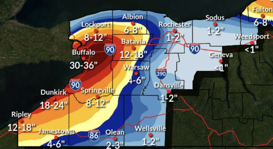
https://www.dailymail.co.uk/news/article-11435055/Paralyzing-lake-storm-effect-set-hit-upper-New-York-state-Buffalo-set-buried-snow.html

weatherwatchermom- Senior Enthusiast

- Posts : 3874
Reputation : 78
Join date : 2014-11-25
Location : Hazlet Township, NJ
 Re: November Obs & Discussions
Insane, especially this early. 4-6 ft, if thats impossible travel up there imagine what that would be here, we would be stranded home probably till spring.weatherwatchermom wrote:
https://www.dailymail.co.uk/news/article-11435055/Paralyzing-lake-storm-effect-set-hit-upper-New-York-state-Buffalo-set-buried-snow.html

jmanley32- Senior Enthusiast

- Posts : 20635
Reputation : 108
Join date : 2013-12-12
Age : 43
Location : Yonkers, NY
 Re: November Obs & Discussions


SENJsnowman- Senior Enthusiast

- Posts : 1195
Reputation : 61
Join date : 2017-01-06
Age : 51
Location : Long Branch, NJ
 Re: November Obs & Discussions
_________________
Mugs
AKA:King: Snow Weenie
Self Proclaimed
WINTER 2014-15 : 55.12" +.02 for 6 coatings (avg. 35")
WINTER 2015-16 Total - 29.8" (Avg 35")
WINTER 2016-17 : 39.5" so far

amugs- Advanced Forecaster - Mod

- Posts : 15130
Reputation : 213
Join date : 2013-01-07
Age : 54
Location : Hillsdale,NJ
 Re: November Obs & Discussions

jmanley32- Senior Enthusiast

- Posts : 20635
Reputation : 108
Join date : 2013-12-12
Age : 43
Location : Yonkers, NY
amugs likes this post
 Re: November Obs & Discussions
jmanley32 wrote:Humina 00z gfs! Tri state gets hit with 42 hrs of precip lol damn too bad it's 210 plus hours out
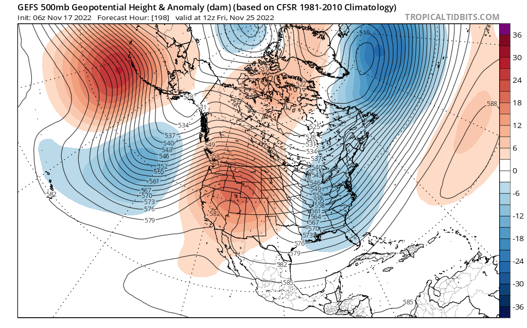
It shows the potential of the pattern - EURO is a monster rainstorm. It originates from teh Bay of Tampico in Mexico.
Great read from Will C - the ridge axis but more so the EPO is so importnat - it is MUCh stronger than modeled which will have dwosntream efects from coast to coast
2/6 We will use Euro ensemble 24 hr trends for today's discussion...starting above at 500mb there are two key features to watch, the ridge out west and where the vortex sets up over ECAN 48 hrs prior to storm..left new, right old..the more it presses south the more it... pic.twitter.com/CEtc1QqFoV
— Will C (@weatherwilly) November 17, 2022
_________________
Mugs
AKA:King: Snow Weenie
Self Proclaimed
WINTER 2014-15 : 55.12" +.02 for 6 coatings (avg. 35")
WINTER 2015-16 Total - 29.8" (Avg 35")
WINTER 2016-17 : 39.5" so far

amugs- Advanced Forecaster - Mod

- Posts : 15130
Reputation : 213
Join date : 2013-01-07
Age : 54
Location : Hillsdale,NJ
 Re: November Obs & Discussions
ya gfs 06z is also huge rain and wind storm 976mb over cape cod. Normal noreastsr what do we need to get signed snow to coast or is that even posdible?amugs wrote:jmanley32 wrote:Humina 00z gfs! Tri state gets hit with 42 hrs of precip lol damn too bad it's 210 plus hours out
It shows the potential of the pattern - EURO is a monster rainstorm. It originates from teh Bay of Tampico in Mexico.
Great read from Will C - the ridge axis but more so the EPO is so importnat - it is MUCh stronger than modeled which will have dwosntream efects from coast to coast2/6 We will use Euro ensemble 24 hr trends for today's discussion...starting above at 500mb there are two key features to watch, the ridge out west and where the vortex sets up over ECAN 48 hrs prior to storm..left new, right old..the more it presses south the more it... pic.twitter.com/CEtc1QqFoV
— Will C (@weatherwilly) November 17, 2022

jmanley32- Senior Enthusiast

- Posts : 20635
Reputation : 108
Join date : 2013-12-12
Age : 43
Location : Yonkers, NY
 Re: November Obs & Discussions
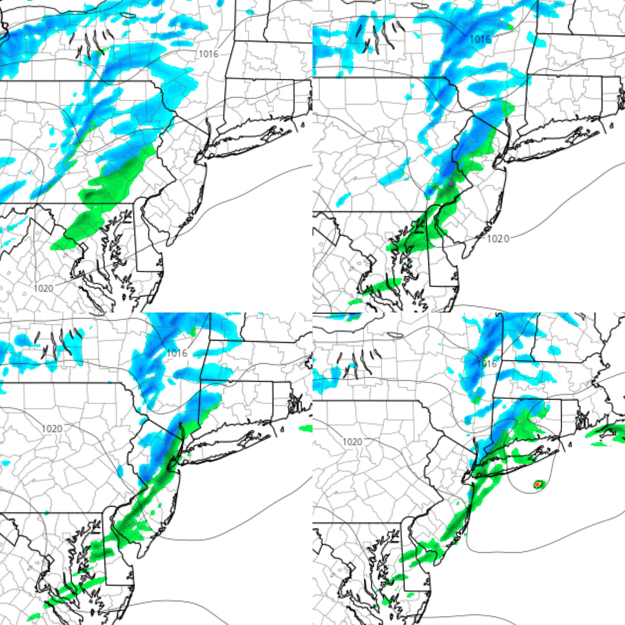
For Friday - some graupel, sleet and snow!!
_________________
Mugs
AKA:King: Snow Weenie
Self Proclaimed
WINTER 2014-15 : 55.12" +.02 for 6 coatings (avg. 35")
WINTER 2015-16 Total - 29.8" (Avg 35")
WINTER 2016-17 : 39.5" so far

amugs- Advanced Forecaster - Mod

- Posts : 15130
Reputation : 213
Join date : 2013-01-07
Age : 54
Location : Hillsdale,NJ
 Re: November Obs & Discussions
jmanley32 wrote:ya gfs 06z is also huge rain and wind storm 976mb over cape cod. Normal nor'easter what do we need to get signed snow to coast or is that even possible?amugs wrote:jmanley32 wrote:Humina 00z gfs! Tri state gets hit with 42 hrs of precip lol damn too bad it's 210 plus hours out
It shows the potential of the pattern - EURO is a monster rainstorm. It originates from teh Bay of Tampico in Mexico.
Great read from Will C - the ridge axis but more so the EPO is so importnat - it is MUCh stronger than modeled which will have dwosntream efects from coast to coast2/6 We will use Euro ensemble 24 hr trends for today's discussion...starting above at 500mb there are two key features to watch, the ridge out west and where the vortex sets up over ECAN 48 hrs prior to storm..left new, right old..the more it presses south the more it... pic.twitter.com/CEtc1QqFoV
— Will C (@weatherwilly) November 17, 2022
You need the PNA ridge to trend stronger, and or there to be well timed confluence, ie: in the form of a 50/50 low or something similar, to the NE, ahead of the system. This will aid in reinforcing a Polar HP to our north keeping the cold air in place deterring the primary LP from cutting N and west which would shift the mid level winds off the anomalously warm ocean waters bringing the rain, sleet, Zr, slop into the equation.
_________________
"In weather and in life, there's no winning and losing; there's only winning and learning."
WINTER 2012/2013 TOTALS 43.65"WINTER 2017/2018 TOTALS 62.85" WINTER 2022/2023 TOTALS 4.9"
WINTER 2013/2014 TOTALS 64.85"WINTER 2018/2019 TOTALS 14.25" WINTER 2023/2024 TOTALS 13.1"
WINTER 2014/2015 TOTALS 71.20"WINTER 2019/2020 TOTALS 6.35"
WINTER 2015/2016 TOTALS 35.00"WINTER 2020/2021 TOTALS 37.75"
WINTER 2016/2017 TOTALS 42.25"WINTER 2021/2022 TOTALS 31.65"

sroc4- Admin

- Posts : 8441
Reputation : 302
Join date : 2013-01-07
Location : Wading River, LI

algae888- Advanced Forecaster

- Posts : 5311
Reputation : 46
Join date : 2013-02-05
Age : 62
Location : mt. vernon, new york
 Re: November Obs & Discussions
12z GFS was a good hit for far northern people and NW jersey verbatim some see 1.5 ft. Coast sees maybe a few inches verbatim and a ton rain/wind. I still find that hard to believe this early but man that is a intense LP and models are consistent on something happening, it is just a matter of what sroc and Al just said. Long ways to go. I would prefer it to come on Saturday as will be traveling a fairly long distance Friday in the tri-state. Rain no problem, dumping snow more than wel come but would make travel hard.sroc4 wrote:jmanley32 wrote:ya gfs 06z is also huge rain and wind storm 976mb over cape cod. Normal nor'easter what do we need to get signed snow to coast or is that even possible?amugs wrote:jmanley32 wrote:Humina 00z gfs! Tri state gets hit with 42 hrs of precip lol damn too bad it's 210 plus hours out
It shows the potential of the pattern - EURO is a monster rainstorm. It originates from teh Bay of Tampico in Mexico.
Great read from Will C - the ridge axis but more so the EPO is so importnat - it is MUCh stronger than modeled which will have dwosntream efects from coast to coast2/6 We will use Euro ensemble 24 hr trends for today's discussion...starting above at 500mb there are two key features to watch, the ridge out west and where the vortex sets up over ECAN 48 hrs prior to storm..left new, right old..the more it presses south the more it... pic.twitter.com/CEtc1QqFoV
— Will C (@weatherwilly) November 17, 2022
You need the PNA ridge to trend stronger, and or there to be well timed confluence, ie: in the form of a 50/50 low or something similar, to the NE, ahead of the system. This will aid in reinforcing a Polar HP to our north keeping the cold air in place deterring the primary LP from cutting N and west which would shift the mid level winds off the anomalously warm ocean waters bringing the rain, sleet, Zr, slop into the equation.

jmanley32- Senior Enthusiast

- Posts : 20635
Reputation : 108
Join date : 2013-12-12
Age : 43
Location : Yonkers, NY
 Re: November Obs & Discussions
jmanley32 wrote:12z GFS was a good hit for far northern people and NW jersey verbatim some see 1.5 ft. Coast sees maybe a few inches verbatim and a ton rain/wind. I still find that hard to believe this early but man that is a intense LP and models are consistent on something happening, it is just a matter of what sroc and Al just said. Long ways to go. I would prefer it to come on Saturday as will be traveling a fairly long distance Friday in the tri-state. Rain no problem, dumping snow more than wel come but would make travel hard.sroc4 wrote:jmanley32 wrote:ya gfs 06z is also huge rain and wind storm 976mb over cape cod. Normal nor'easter what do we need to get signed snow to coast or is that even possible?amugs wrote:jmanley32 wrote:Humina 00z gfs! Tri state gets hit with 42 hrs of precip lol damn too bad it's 210 plus hours out
It shows the potential of the pattern - EURO is a monster rainstorm. It originates from teh Bay of Tampico in Mexico.
Great read from Will C - the ridge axis but more so the EPO is so importnat - it is MUCh stronger than modeled which will have dwosntream efects from coast to coast2/6 We will use Euro ensemble 24 hr trends for today's discussion...starting above at 500mb there are two key features to watch, the ridge out west and where the vortex sets up over ECAN 48 hrs prior to storm..left new, right old..the more it presses south the more it... pic.twitter.com/CEtc1QqFoV
— Will C (@weatherwilly) November 17, 2022
You need the PNA ridge to trend stronger, and or there to be well timed confluence, ie: in the form of a 50/50 low or something similar, to the NE, ahead of the system. This will aid in reinforcing a Polar HP to our north keeping the cold air in place deterring the primary LP from cutting N and west which would shift the mid level winds off the anomalously warm ocean waters bringing the rain, sleet, Zr, slop into the equation.
Ehhh Im not looking at hit no hit or who see what with precip types. That's all banter at this lead time IMO. Just focused on 500mb and timing and positioning and strength of the key pieces of energy. Still huge differences between models and within a given model from one run to the next. Nothing to get excited about yet.
_________________
"In weather and in life, there's no winning and losing; there's only winning and learning."
WINTER 2012/2013 TOTALS 43.65"WINTER 2017/2018 TOTALS 62.85" WINTER 2022/2023 TOTALS 4.9"
WINTER 2013/2014 TOTALS 64.85"WINTER 2018/2019 TOTALS 14.25" WINTER 2023/2024 TOTALS 13.1"
WINTER 2014/2015 TOTALS 71.20"WINTER 2019/2020 TOTALS 6.35"
WINTER 2015/2016 TOTALS 35.00"WINTER 2020/2021 TOTALS 37.75"
WINTER 2016/2017 TOTALS 42.25"WINTER 2021/2022 TOTALS 31.65"

sroc4- Admin

- Posts : 8441
Reputation : 302
Join date : 2013-01-07
Location : Wading River, LI
 Re: November Obs & Discussions
10-4 boss lolsroc4 wrote:jmanley32 wrote:12z GFS was a good hit for far northern people and NW jersey verbatim some see 1.5 ft. Coast sees maybe a few inches verbatim and a ton rain/wind. I still find that hard to believe this early but man that is a intense LP and models are consistent on something happening, it is just a matter of what sroc and Al just said. Long ways to go. I would prefer it to come on Saturday as will be traveling a fairly long distance Friday in the tri-state. Rain no problem, dumping snow more than wel come but would make travel hard.sroc4 wrote:jmanley32 wrote:ya gfs 06z is also huge rain and wind storm 976mb over cape cod. Normal nor'easter what do we need to get signed snow to coast or is that even possible?amugs wrote:jmanley32 wrote:Humina 00z gfs! Tri state gets hit with 42 hrs of precip lol damn too bad it's 210 plus hours out
It shows the potential of the pattern - EURO is a monster rainstorm. It originates from teh Bay of Tampico in Mexico.
Great read from Will C - the ridge axis but more so the EPO is so importnat - it is MUCh stronger than modeled which will have dwosntream efects from coast to coast2/6 We will use Euro ensemble 24 hr trends for today's discussion...starting above at 500mb there are two key features to watch, the ridge out west and where the vortex sets up over ECAN 48 hrs prior to storm..left new, right old..the more it presses south the more it... pic.twitter.com/CEtc1QqFoV
— Will C (@weatherwilly) November 17, 2022
You need the PNA ridge to trend stronger, and or there to be well timed confluence, ie: in the form of a 50/50 low or something similar, to the NE, ahead of the system. This will aid in reinforcing a Polar HP to our north keeping the cold air in place deterring the primary LP from cutting N and west which would shift the mid level winds off the anomalously warm ocean waters bringing the rain, sleet, Zr, slop into the equation.
Ehhh Im not looking at hit no hit or who see what with precip types. That's all banter at this lead time IMO. Just focused on 500mb and timing and positioning and strength of the key pieces of energy. Still huge differences between models and within a given model from one run to the next. Nothing to get excited about yet.

jmanley32- Senior Enthusiast

- Posts : 20635
Reputation : 108
Join date : 2013-12-12
Age : 43
Location : Yonkers, NY
 Re: November Obs & Discussions

weatherwatchermom- Senior Enthusiast

- Posts : 3874
Reputation : 78
Join date : 2014-11-25
Location : Hazlet Township, NJ
 Re: November Obs & Discussions
_________________
Mugs
AKA:King: Snow Weenie
Self Proclaimed
WINTER 2014-15 : 55.12" +.02 for 6 coatings (avg. 35")
WINTER 2015-16 Total - 29.8" (Avg 35")
WINTER 2016-17 : 39.5" so far

amugs- Advanced Forecaster - Mod

- Posts : 15130
Reputation : 213
Join date : 2013-01-07
Age : 54
Location : Hillsdale,NJ
jmanley32 and weatherwatchermom like this post
Page 5 of 7 •  1, 2, 3, 4, 5, 6, 7
|
|
|

 Home
Home