November Obs & Discussions
+20
algae888
Grselig
aiannone
sroc4
brownie
SENJsnowman
MattyICE
dkodgis
Sparky Sparticles
GreyBeard
docstox12
weatherwatchermom
jmanley32
frank 638
HectorO
Dunnzoo
Quietace
billg315
amugs
Frank_Wx
24 posters
Page 2 of 7 •  1, 2, 3, 4, 5, 6, 7
 Re: November Obs & Discussions
GreyBeard wrote:Looks like the bottom drops out tonight though, predicting lows in the 40's, so at least a 30° swing.
My adult son just had the flu last week and still isn't 100%.
He works nights, so later today it'll still be near 80º when he goes in, but when he comes home at 6am it'll be closer to 40º. He's hoping he doesn't get sick all over again.
Sparky Sparticles- Posts : 124
Join date : 2014-02-11
 Re: November Obs & Discussions
Sparky Sparticles wrote:GreyBeard wrote:Looks like the bottom drops out tonight though, predicting lows in the 40's, so at least a 30° swing.
My adult son just had the flu last week and still isn't 100%.
He works nights, so later today it'll still be near 80º when he goes in, but when he comes home at 6am it'll be closer to 40º. He's hoping he doesn't get sick all over again.
64 on the way down to 36, clear and calm winds.
These temperature swings do not help with colds and flu for sure.
docstox12- Wx Statistician Guru

- Posts : 8530
Join date : 2013-01-07
 Re: November Obs & Discussions
_________________
Mugs
AKA:King: Snow Weenie
Self Proclaimed
WINTER 2014-15 : 55.12" +.02 for 6 coatings (avg. 35")
WINTER 2015-16 Total - 29.8" (Avg 35")
WINTER 2016-17 : 39.5" so far

amugs- Advanced Forecaster - Mod

- Posts : 15095
Reputation : 213
Join date : 2013-01-07
Age : 54
Location : Hillsdale,NJ
 Re: November Obs & Discussions
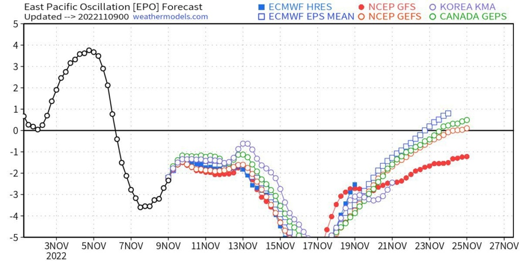
0z EPS Control has 2 East Coast #Snow Storms in the Nov 15-18th timeframe. This is supported by the recent SOI drop. #wxtwitter pic.twitter.com/r554Sf5obn
— Mark Margavage (@MeteoMark) November 8, 2022
It is possible and would be an insane flip from a week previous
_________________
Mugs
AKA:King: Snow Weenie
Self Proclaimed
WINTER 2014-15 : 55.12" +.02 for 6 coatings (avg. 35")
WINTER 2015-16 Total - 29.8" (Avg 35")
WINTER 2016-17 : 39.5" so far

amugs- Advanced Forecaster - Mod

- Posts : 15095
Reputation : 213
Join date : 2013-01-07
Age : 54
Location : Hillsdale,NJ

jmanley32- Senior Enthusiast

- Posts : 20535
Reputation : 108
Join date : 2013-12-12
Age : 43
Location : Yonkers, NY
 Re: November Obs & Discussions
Ya interaction with the cold from from a tropical/post tropical system never ends well. We have seen that twice in 2020 and 2021. (And it is Nicole mugs, auto correct or were thinking about another woman when writing this lmao)

jmanley32- Senior Enthusiast

- Posts : 20535
Reputation : 108
Join date : 2013-12-12
Age : 43
Location : Yonkers, NY
amugs likes this post
 Re: November Obs & Discussions
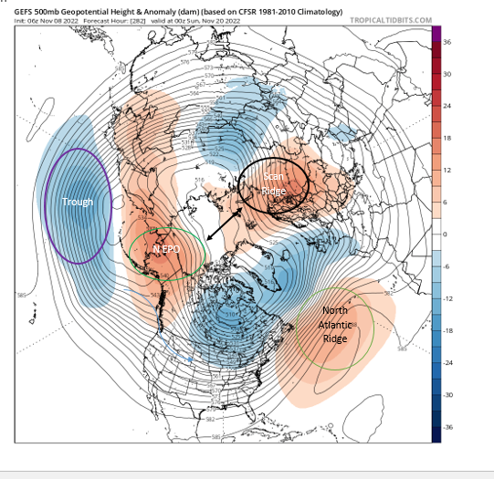
This is a normalize look but let’s look at the Arctic shall we.
Alaska has a N EPO (green circle) with a nice ridge that has built and the trough to its S and W (purple circle) helps pump this ridge.
The black circle area is the Scandinavian Ridge that is backing up or building what looks to be a "Ridge Bridge" over the Arctic as indicated by the black 2-way arrow to the EPO region - Green Circle and into Greenland. This will help dislodge cold and keep the SE Ridge at bay, tamper it. The North Atlantic ridge that is from the anomalous warm waters is building back a bit but we'll see how this play out. This is not a warm ridge like the SE ridge.
The Big Trough over Canada is not bad for it will act as a freezer up there and build a snowpack this time of year.

_________________
Mugs
AKA:King: Snow Weenie
Self Proclaimed
WINTER 2014-15 : 55.12" +.02 for 6 coatings (avg. 35")
WINTER 2015-16 Total - 29.8" (Avg 35")
WINTER 2016-17 : 39.5" so far

amugs- Advanced Forecaster - Mod

- Posts : 15095
Reputation : 213
Join date : 2013-01-07
Age : 54
Location : Hillsdale,NJ
 Re: November Obs & Discussions
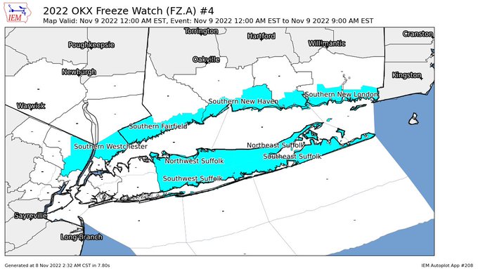
First Freeze Watch Tonight even though I had one 10 days ago, what the heck?

_________________
Mugs
AKA:King: Snow Weenie
Self Proclaimed
WINTER 2014-15 : 55.12" +.02 for 6 coatings (avg. 35")
WINTER 2015-16 Total - 29.8" (Avg 35")
WINTER 2016-17 : 39.5" so far

amugs- Advanced Forecaster - Mod

- Posts : 15095
Reputation : 213
Join date : 2013-01-07
Age : 54
Location : Hillsdale,NJ
 Re: November Obs & Discussions
A few thoughts on the coming days (weeks):
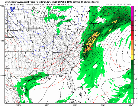
1. I think the timing of Nicole is interesting. We were likely to get some heavy rain (and maybe storms) from a frontal passage this weekend anyway as the cold air surges in heralding the pattern change this weekend. If that frontal system interacts the right way with Nicole as she charges up the Eastern seaboard Friday into Saturday, I think we could get quite a wallop from this system. Heavy rain, flooding, wind damage and severe weather. Friday into Saturday could get real interesting around here, not in a good way.
2. This cold air that will be settling in after this weekend is potent for this time of year. I would not at all be surprised to see us get our first snow/frozen precipitation event between this weekend and Thanksgiving. The antecedent air mass will support frozen precip, we just need the right type of storm/track coming through.

billg315- Advanced Forecaster - Mod

- Posts : 4483
Reputation : 185
Join date : 2015-01-24
Age : 50
Location : Flemington, NJ
Frank_Wx and sroc4 like this post
 Re: November Obs & Discussions
I agree, I keep saying seems somewhat similar to Isiais in 2020 where he became cold core and I believe got caught up in a frontal system, or it was the remnants of Ida. Nonetheless I agree that even if it is not a true TS wind even I think there will be severe t-storms and really heavy rain to contend with. It was Isiais that did a similar thing though was purely tropical still but I believe still got caight up in st hence his super fast race in and out. The track is identical too. No I am not saying the same impacts will happen but seems similar in some respects.billg315 wrote:A few thoughts on the coming days (weeks):
1. I think the timing of Nicole is interesting. We were likely to get some heavy rain (and maybe storms) from a frontal passage this weekend anyway as the cold air surges in heralding the pattern change this weekend. If that frontal system interacts the right way with Nicole as she charges up the Eastern seaboard Friday into Saturday, I think we could get quite a wallop from this system. Heavy rain, flooding, wind damage and severe weather. Friday into Saturday could get real interesting around here, not in a good way.
2. This cold air that will be settling in after this weekend is potent for this time of year. I would not at all be surprised to see us get our first snow/frozen precipitation event between this weekend and Thanksgiving. The antecedent air mass will support frozen precip, we just need the right type of storm/track coming through.
https://en.wikipedia.org/wiki/Hurricane_Isaias

jmanley32- Senior Enthusiast

- Posts : 20535
Reputation : 108
Join date : 2013-12-12
Age : 43
Location : Yonkers, NY
 Re: November Obs & Discussions
We may have been saved rain-wise this weekend. The tropical low is shown to pass to our west-northwest, keeping the heaviest rains away from our area. We'll see if this trends east again, but I doubt it.


_________________
_______________________________________________________________________________________________________
CLICK HERE to view NJ Strong Snowstorm Classifications
 Re: November Obs & Discussions
Models are showing sig winds or will that not mix down without the rain making this a total non-event. Models still shows 1-2 inches or so.Frank_Wx wrote:We may have been saved rain-wise this weekend. The tropical low is shown to pass to our west-northwest, keeping the heaviest rains away from our area. We'll see if this trends east again, but I doubt it.

jmanley32- Senior Enthusiast

- Posts : 20535
Reputation : 108
Join date : 2013-12-12
Age : 43
Location : Yonkers, NY
 Re: November Obs & Discussions
Right now the modeling continues to show the heaviest rain staying to our west across PA as Frank pointed out. Although, even if the 2-3" amounts stay to our west we probably still get over an inch of rain during the 24-hour duration of the event (which appears to be from about late morning Friday until late morning Saturday).
As for the winds, we were probably destined to have gusty winds this weekend anyway with the frontal passage and shift in temperatures so I suspect even if we miss out on the core of the heaviest rain, we still may have fairly strong winds Friday into Saturday with whatever rain we do get.
As for the winds, we were probably destined to have gusty winds this weekend anyway with the frontal passage and shift in temperatures so I suspect even if we miss out on the core of the heaviest rain, we still may have fairly strong winds Friday into Saturday with whatever rain we do get.

billg315- Advanced Forecaster - Mod

- Posts : 4483
Reputation : 185
Join date : 2015-01-24
Age : 50
Location : Flemington, NJ
 Re: November Obs & Discussions
As JMAN said about 2" of rain from this


_________________
Mugs
AKA:King: Snow Weenie
Self Proclaimed
WINTER 2014-15 : 55.12" +.02 for 6 coatings (avg. 35")
WINTER 2015-16 Total - 29.8" (Avg 35")
WINTER 2016-17 : 39.5" so far

amugs- Advanced Forecaster - Mod

- Posts : 15095
Reputation : 213
Join date : 2013-01-07
Age : 54
Location : Hillsdale,NJ
 Re: November Obs & Discussions
_________________
Mugs
AKA:King: Snow Weenie
Self Proclaimed
WINTER 2014-15 : 55.12" +.02 for 6 coatings (avg. 35")
WINTER 2015-16 Total - 29.8" (Avg 35")
WINTER 2016-17 : 39.5" so far

amugs- Advanced Forecaster - Mod

- Posts : 15095
Reputation : 213
Join date : 2013-01-07
Age : 54
Location : Hillsdale,NJ
 Re: November Obs & Discussions
Well looks like Nicoles remnants and the front will be no big deal, maybe a inch of rain and gusts 30-40mph tops late friday night into Sat morning. Onto the next am I seeing SNOW on the GFS twice and the fact there could even be down to the coast, more interested in that : )

jmanley32- Senior Enthusiast

- Posts : 20535
Reputation : 108
Join date : 2013-12-12
Age : 43
Location : Yonkers, NY
 Re: November Obs & Discussions
Looks like the “more” of this storm is slightly to the east on a few models. I think as a limited layperson this means (even) more rain than two inches
Last edited by dkodgis on Fri Nov 11, 2022 4:12 pm; edited 1 time in total

dkodgis- Senior Enthusiast

- Posts : 2560
Reputation : 98
Join date : 2013-12-29
jmanley32 likes this post
 Re: November Obs & Discussions
Heavy heavy rain incoming to NY how bad are those bands in NJ? Do you guys think there will be severe storms in westcester or NYC area or the wind advisory be expanded west? It seems like such a sharp cut off.

jmanley32- Senior Enthusiast

- Posts : 20535
Reputation : 108
Join date : 2013-12-12
Age : 43
Location : Yonkers, NY
 Re: November Obs & Discussions
jmanley32 wrote:Heavy heavy rain incoming to NY how bad are those bands in NJ? Do you guys think there will be severe storms in westcester or NYC area or the wind advisory be expanded west? It seems like such a sharp cut off.
The rain bands in NE NJ are pretty legit. But intermittent. And, at least where I am, hardly any wind associated.
MattyICE- Advanced Forecaster

- Posts : 249
Reputation : 6
Join date : 2017-11-10
Age : 38
Location : Clifton, NJ (Eastern Passaic County)
 Re: November Obs & Discussions
They look to be more intense and steady late tonight and early am tomorrow. For me now, scattered rain. Wind is starting to say hello. A few gusts up to say low 20-ies mph. Maybe the wind will pick up and stay high, especially near the coastline

dkodgis- Senior Enthusiast

- Posts : 2560
Reputation : 98
Join date : 2013-12-29
 Re: November Obs & Discussions
looks like from look at Sr models the intensity of the winds increase as they pass most of the area hence the eindadvisory for LI to MA but it's all semantics. Its a deluge here right now. Def easily go see over a inch of rain maybe 2 to 3dkodgis wrote:They look to be more intense and steady late tonight and early am tomorrow. For me now, scattered rain. Wind is starting to say hello. A few gusts up to say low 20-ies mph. Maybe the wind will pick up and stay high, especially near the coastline

jmanley32- Senior Enthusiast

- Posts : 20535
Reputation : 108
Join date : 2013-12-12
Age : 43
Location : Yonkers, NY
 Re: November Obs & Discussions
ur not far from me I been to.clifton many times. Ya winds won't kick in until late tonight into morning. If at all. Actually a bit windy with heaviest rain. Which makes sense.MattyICE wrote:jmanley32 wrote:Heavy heavy rain incoming to NY how bad are those bands in NJ? Do you guys think there will be severe storms in westcester or NYC area or the wind advisory be expanded west? It seems like such a sharp cut off.
The rain bands in NE NJ are pretty legit. But intermittent. And, at least where I am, hardly any wind associated.

jmanley32- Senior Enthusiast

- Posts : 20535
Reputation : 108
Join date : 2013-12-12
Age : 43
Location : Yonkers, NY
 Re: November Obs & Discussions
_________________
Mugs
AKA:King: Snow Weenie
Self Proclaimed
WINTER 2014-15 : 55.12" +.02 for 6 coatings (avg. 35")
WINTER 2015-16 Total - 29.8" (Avg 35")
WINTER 2016-17 : 39.5" so far

amugs- Advanced Forecaster - Mod

- Posts : 15095
Reputation : 213
Join date : 2013-01-07
Age : 54
Location : Hillsdale,NJ
 Re: November Obs & Discussions
Mugs, I too have 1.25 inches
it is 51 here with fog. I think it won't go down past 51 for tonight
it is 51 here with fog. I think it won't go down past 51 for tonight

dkodgis- Senior Enthusiast

- Posts : 2560
Reputation : 98
Join date : 2013-12-29
amugs likes this post
 Re: November Obs & Discussions
Looks like rain is done for good, future radar shows no rain for anywhere in tri-state except CT (central to eastern) all the rest well to the west across western PA and through Canada. Maybe we see some wind but likely not as is usually winds almost never play out.

jmanley32- Senior Enthusiast

- Posts : 20535
Reputation : 108
Join date : 2013-12-12
Age : 43
Location : Yonkers, NY
 Re: November Obs & Discussions
67 * very humid muggy out I look forward for the cooler weather.Tom another day of cleaning up leaves  I just did yesterday
frank 638- Senior Enthusiast

- Posts : 2843
Reputation : 37
Join date : 2016-01-01
Age : 40
Location : bronx ny
weatherwatchermom likes this post
 Re: November Obs & Discussions
frank 638 wrote:67 * very humid muggy out I look forward for the cooler weather.Tom another day of cleaning up leavesI just did yesterday
Our yard yesterday did not have one leaf..looked beautiful ready for winter. . let's see tom..

weatherwatchermom- Senior Enthusiast

- Posts : 3793
Reputation : 78
Join date : 2014-11-25
Location : Hazlet Township, NJ
Page 2 of 7 •  1, 2, 3, 4, 5, 6, 7
Permissions in this forum:
You cannot reply to topics in this forum|
|
|

 Home
Home