March 13th-14th "Agita" Storm Part II
+37
Artingerb
Vinnydula
essexcountypete
DAYBLAZER
brownie
crippo84
2004blackwrx
tomsriversnowstorm
billg315
Scullybutcher
dsix85
aiannone
SENJsnowman
kalleg
sroc4
Radz
phil155
docstox12
1190ftalt
SNOW MAN
TheAresian
hyde345
Dunnzoo
MattyICE
dkodgis
CPcantmeasuresnow
lglickman1
frank 638
rb924119
nutleyblizzard
Coachgriff
amugs
CNWestMilford
weatherwatchermom
jmanley32
heehaw453
Frank_Wx
41 posters
Page 1 of 15
Page 1 of 15 • 1, 2, 3 ... 8 ... 15 
 March 13th-14th "Agita" Storm Part II
This storm certainly has given us the most heartburn in what has been that type of winter. Hopes are high that we can deliver with this one, but it is an uphill battle and one I fear we may lose. But you just never know with storms of these magnitudes.
EURO 500mb vort tracks last 4 model runs (exclu. 6z/18z)
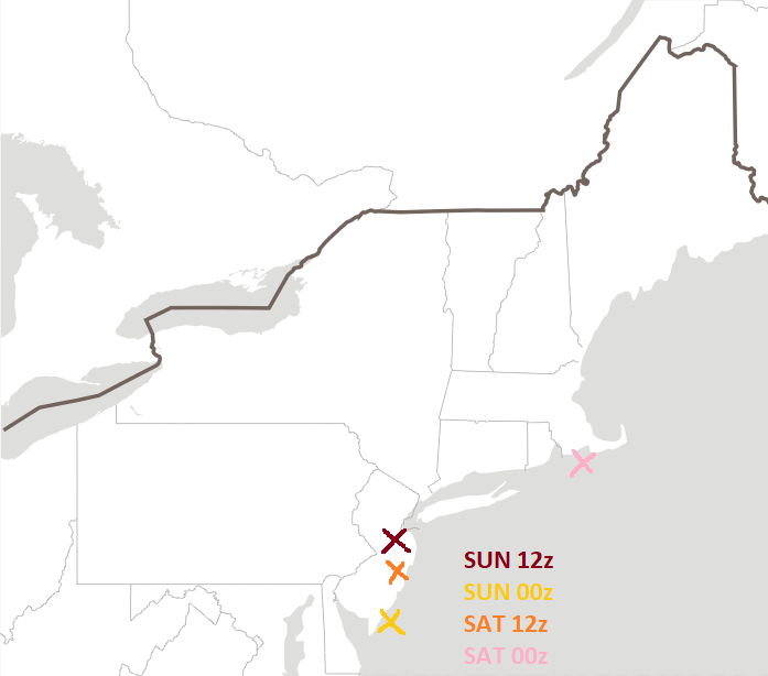
The EURO has made significant progression toward a colder/snowier solution for the coast. As recently as 00z Saturday (pink 'X') the 500mb ULL was not even closed off at our latitude. It was an open trough with energy scattered throughout until it got to southern New England. Fast forward to last night, and it closed 500mb in a very ideal location for most on here (unfortunately CNJ/SNJ you've kinda been out on this one since its inception). But today at 12z it closed off further north, which put the heaviest axis of snows more N&W. A shift of such few miles but DRASTIC impacts.
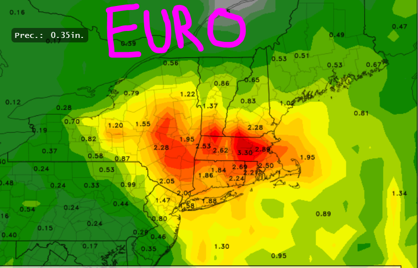
EURO total precip
GFS total precip

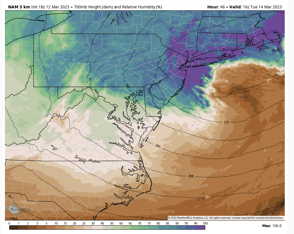
The two models are not far off at all precip-wise. It is easy to see where the bullseye of this storm will be regardless of rain or snow. The question is how much of this precip falls as rain versus snow? That all depends on the 500mb/700mb layers and what happens there.
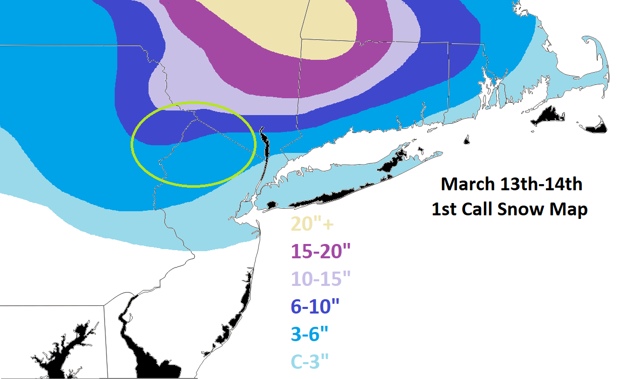
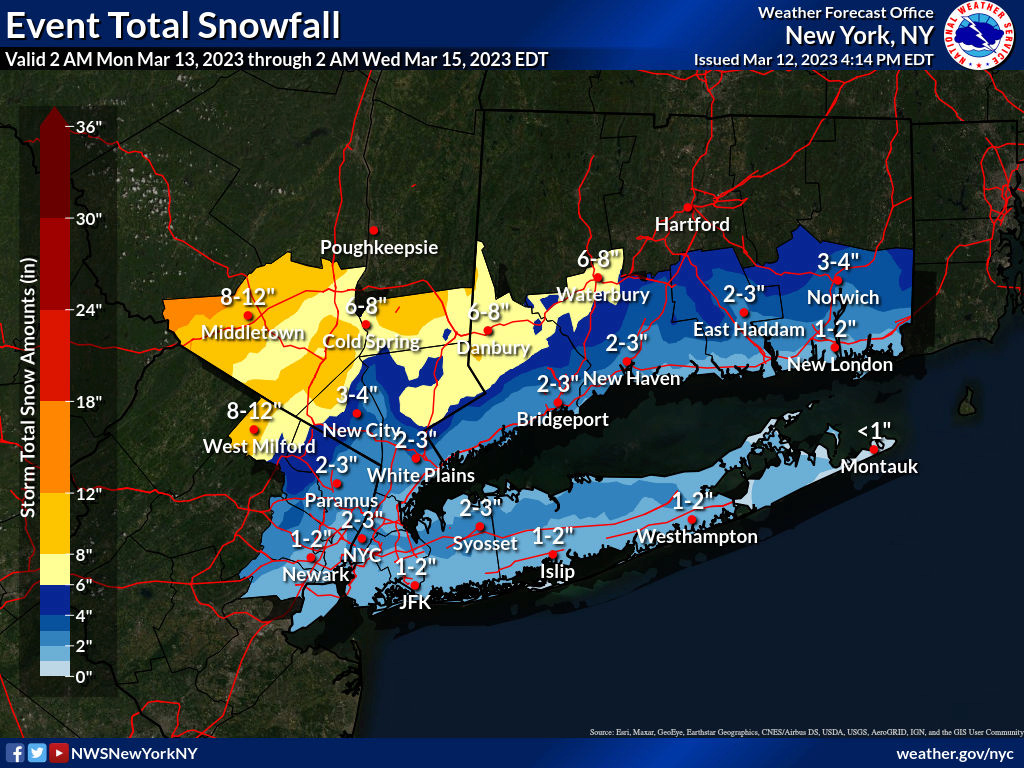
This is my best guess right now. Again, storms of this size are hard to forecast and minor changes have a big impact. I circled in green the area of uncertainty. Obviously if you are in higher elevations (specifically in this area), I would add a few inches to what you see here. Unfortunately the pattern aloft (think big picture like PNA, NAO, AO, etc.) just were not quite right. Especially when you factor in we're in March and need more of these things to line up to get a big snowfall. I know I'm sounding like this one is already over. FAR FROM IT! Still another night of model runs to see if changes happen. If so, a new map will be issued.
EURO 500mb vort tracks last 4 model runs (exclu. 6z/18z)

The EURO has made significant progression toward a colder/snowier solution for the coast. As recently as 00z Saturday (pink 'X') the 500mb ULL was not even closed off at our latitude. It was an open trough with energy scattered throughout until it got to southern New England. Fast forward to last night, and it closed 500mb in a very ideal location for most on here (unfortunately CNJ/SNJ you've kinda been out on this one since its inception). But today at 12z it closed off further north, which put the heaviest axis of snows more N&W. A shift of such few miles but DRASTIC impacts.
EURO total precip

GFS total precip

The two models are not far off at all precip-wise. It is easy to see where the bullseye of this storm will be regardless of rain or snow. The question is how much of this precip falls as rain versus snow? That all depends on the 500mb/700mb layers and what happens there.

This is my best guess right now. Again, storms of this size are hard to forecast and minor changes have a big impact. I circled in green the area of uncertainty. Obviously if you are in higher elevations (specifically in this area), I would add a few inches to what you see here. Unfortunately the pattern aloft (think big picture like PNA, NAO, AO, etc.) just were not quite right. Especially when you factor in we're in March and need more of these things to line up to get a big snowfall. I know I'm sounding like this one is already over. FAR FROM IT! Still another night of model runs to see if changes happen. If so, a new map will be issued.
_________________
_______________________________________________________________________________________________________
CLICK HERE to view NJ Strong Snowstorm Classifications
amugs and CNWestMilford like this post
heehaw453- Advanced Forecaster

- Posts : 3906
Reputation : 86
Join date : 2014-01-20
Location : Bedminster Township, PA Elevation 600' ASL
 Re: March 13th-14th "Agita" Storm Part II
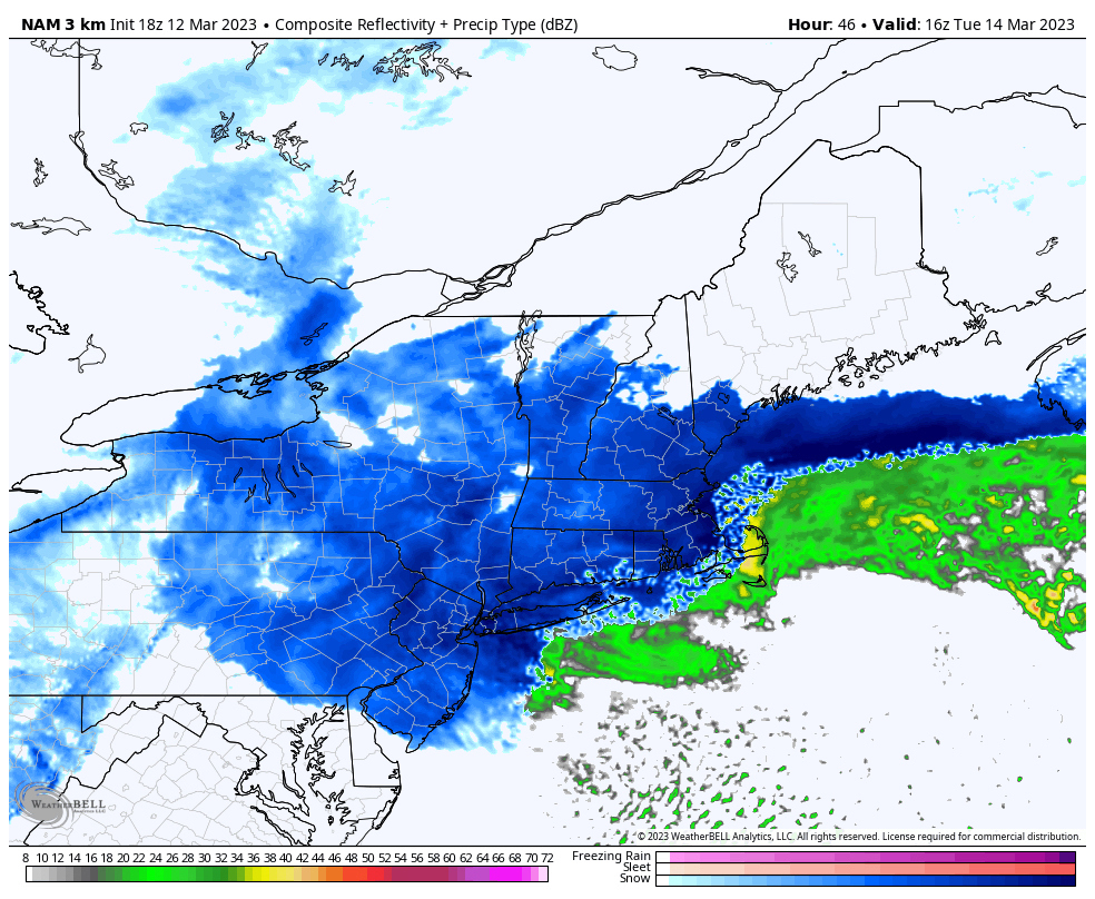
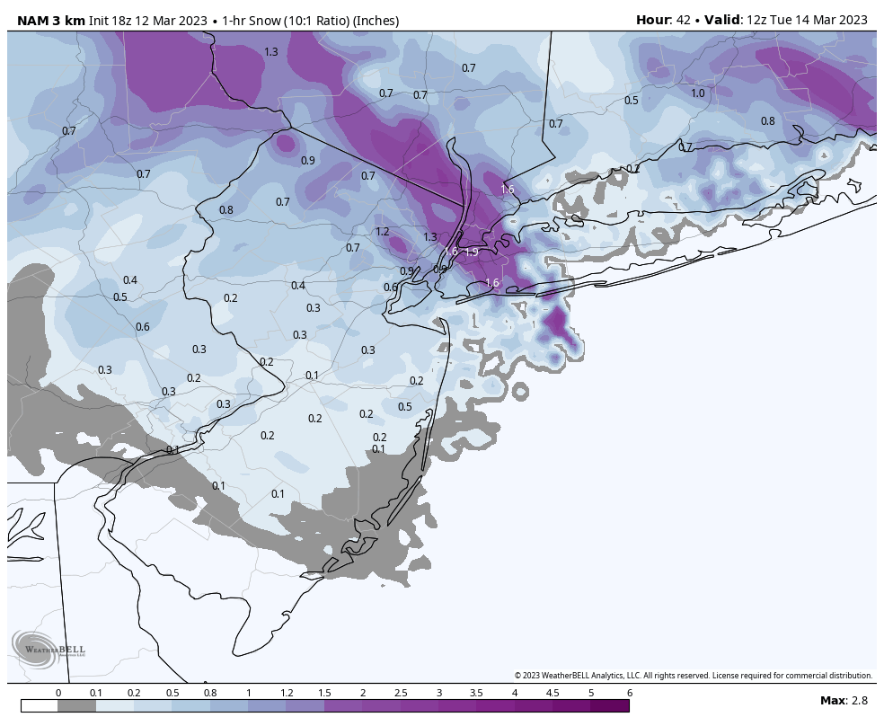
NAM held serve on big snow for coast, not the bullseye but I do not care about that, I really hope we see more than C-3 but it is what it is. And with all that rain i imagine though some snow may fall 0 will stick, so C-3 is likely no accumulation except maybe on colder surfaces. It ain't over till fat lady sings though and I am going to stick it out, isn't the fact that NAM is still showing similar to what last 4 runs a good thing? Euro does not have to change much at 00z to show again what it was before. I know I am prolly pulling at hair strings here but am hoping for a miracle.
Last edited by jmanley32 on Sun Mar 12, 2023 4:42 pm; edited 2 times in total

jmanley32- Senior Enthusiast

- Posts : 20535
Reputation : 108
Join date : 2013-12-12
Age : 43
Location : Yonkers, NY
 Re: March 13th-14th "Agita" Storm Part II
Sad but at least anything has got to be better than the coating on the grass we got once this whole winter...thank you for posting Frank.

weatherwatchermom- Senior Enthusiast

- Posts : 3793
Reputation : 78
Join date : 2014-11-25
Location : Hazlet Township, NJ

jmanley32- Senior Enthusiast

- Posts : 20535
Reputation : 108
Join date : 2013-12-12
Age : 43
Location : Yonkers, NY

CNWestMilford- Posts : 43
Reputation : 1
Join date : 2020-12-15
Age : 47
Location : West Milford
heehaw453 likes this post
 Re: March 13th-14th "Agita" Storm Part II
_________________
Mugs
AKA:King: Snow Weenie
Self Proclaimed
WINTER 2014-15 : 55.12" +.02 for 6 coatings (avg. 35")
WINTER 2015-16 Total - 29.8" (Avg 35")
WINTER 2016-17 : 39.5" so far

amugs- Advanced Forecaster - Mod

- Posts : 15095
Reputation : 213
Join date : 2013-01-07
Age : 54
Location : Hillsdale,NJ
 Re: March 13th-14th "Agita" Storm Part II
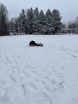
In Frank We Trust….skunked on Winter’s Last Salvo!
Coachgriff- Posts : 57
Reputation : 0
Join date : 2022-01-29

nutleyblizzard- Senior Enthusiast

- Posts : 1954
Reputation : 41
Join date : 2014-01-30
Age : 58
Location : Nutley, new jersey
 Re: March 13th-14th "Agita" Storm Part II
Wow 1.5 per hr right over IMBY, can only hope right mugs, glad at least NAM is holding so far, maybe we have a miracle in the making, the changeover from rain will also have big implications as most start as rain.

jmanley32- Senior Enthusiast

- Posts : 20535
Reputation : 108
Join date : 2013-12-12
Age : 43
Location : Yonkers, NY

jmanley32- Senior Enthusiast

- Posts : 20535
Reputation : 108
Join date : 2013-12-12
Age : 43
Location : Yonkers, NY
 Re: March 13th-14th "Agita" Storm Part II
Nice, Frank! Just my own opinion, but with a H5 trough tilting this negative, and it being this strong, anywhere immediately downstream of that axis is going to fill in on radar, especially as the H7-H85 lows organize below. That’s why I said I personally like the depiction of the extended HRRR for the precip field depiction.
So, I think that coincides well with your circled area of uncertainty, and as the forecaster, it’s great that you highlighted it as the likeliest area for any changes
So, I think that coincides well with your circled area of uncertainty, and as the forecaster, it’s great that you highlighted it as the likeliest area for any changes
rb924119- Meteorologist

- Posts : 6928
Reputation : 194
Join date : 2013-02-06
Age : 32
Location : Greentown, Pa
heehaw453- Advanced Forecaster

- Posts : 3906
Reputation : 86
Join date : 2014-01-20
Location : Bedminster Township, PA Elevation 600' ASL
CNWestMilford likes this post
 Re: March 13th-14th "Agita" Storm Part II
Thanks for the update Frank I was hoping We will get more for the city but you never know
frank 638- Senior Enthusiast

- Posts : 2843
Reputation : 37
Join date : 2016-01-01
Age : 40
Location : bronx ny
 Re: March 13th-14th "Agita" Storm Part II
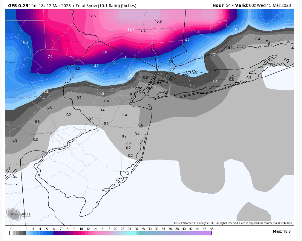
I really don't envy forecasters, how are you supposed to make a cogent forecast when one model shows a prolific amount of snow in a major metropolitan area and one shows almost nothing and its 24 hours out from the event
lglickman1- Pro Enthusiast

- Posts : 319
Reputation : 0
Join date : 2013-02-05
Location : New Rochelle, NY
jmanley32, heehaw453 and weatherwatchermom like this post
 Re: March 13th-14th "Agita" Storm Part II
I work in NR on Huguenot right next to New Roc, if this doesn't produce (and I am not calling anything yet, I take back what I said) maybe we can grab a beer at buffalo wild wings and drink our sorrows away lollglickman1 wrote:I really don't envy forecasters, how are you supposed to make a cogent forecast when one model shows a prolific amount of snow in a major metropolitan area and one shows almost nothing and its 24 hours out from the event

jmanley32- Senior Enthusiast

- Posts : 20535
Reputation : 108
Join date : 2013-12-12
Age : 43
Location : Yonkers, NY
 Re: March 13th-14th "Agita" Storm Part II
@rb924119 going to chase this one in Middleton NY ~600'+ ASL. Good locale?
heehaw453- Advanced Forecaster

- Posts : 3906
Reputation : 86
Join date : 2014-01-20
Location : Bedminster Township, PA Elevation 600' ASL
heehaw453- Advanced Forecaster

- Posts : 3906
Reputation : 86
Join date : 2014-01-20
Location : Bedminster Township, PA Elevation 600' ASL
 Re: March 13th-14th "Agita" Storm Part II
heehaw453 wrote:@rb924119 going to chase this one in Middleton NY ~600'+ ASL. Good locale?
I assume you mean Middletown? Lol not bad. But if you could venture up to Monticello, Bethel, or even Liberty I think you’d be even better off. Again, take what I say with some salt, though, because aside from today, I haven’t been pouring over this threat like you all have. And I’ve only had very limited exposure today as it is haha
rb924119- Meteorologist

- Posts : 6928
Reputation : 194
Join date : 2013-02-06
Age : 32
Location : Greentown, Pa
heehaw453 likes this post
 Re: March 13th-14th "Agita" Storm Part II
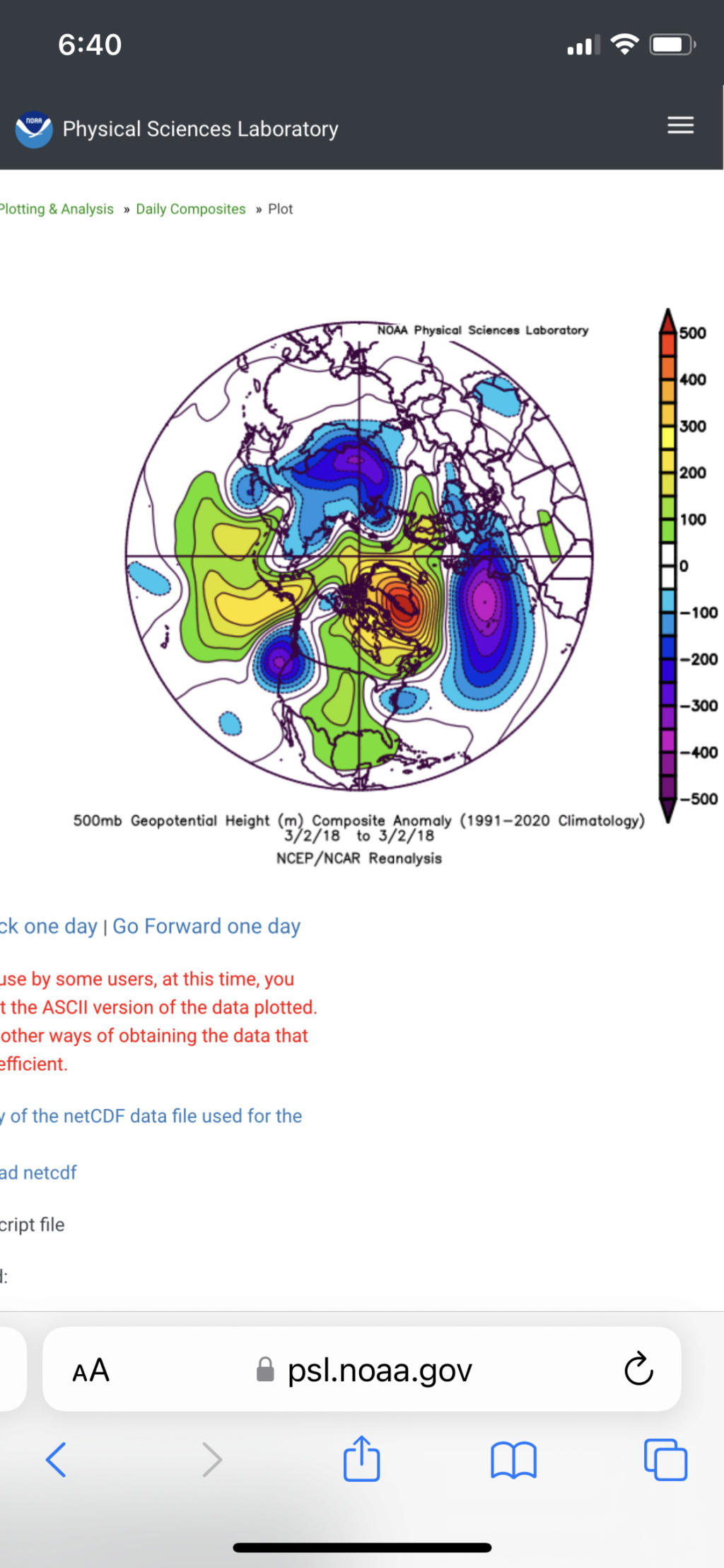
Yes Middletown LoL. Monticello much better elevation, but concerned I might get stranded. I chased a Poconos blizzard in March 2018 about 2' that put my SUV in an embankment. An even 1' would be just fine for me.rb924119 wrote:heehaw453 wrote:@rb924119 going to chase this one in Middleton NY ~600'+ ASL. Good locale?
I assume you mean Middletown? Lol not bad. But if you could venture up to Monticello, Bethel, or even Liberty I think you’d be even better off. Again, take what I say with some salt, though, because aside from today, I haven’t been pouring over this threat like you all have. And I’ve only had very limited exposure today as it is haha
edit: That blizzard was one of the worst I've seen. Up there with Boxing Day which I was around NYC for.
Last edited by heehaw453 on Sun Mar 12, 2023 6:14 pm; edited 1 time in total
heehaw453- Advanced Forecaster

- Posts : 3906
Reputation : 86
Join date : 2014-01-20
Location : Bedminster Township, PA Elevation 600' ASL

CPcantmeasuresnow- Wx Statistician Guru

- Posts : 7274
Reputation : 230
Join date : 2013-01-07
Age : 103
Location : Eastern Orange County, NY
kalleg, RJB8525, essexcountypete, jmanley32, heehaw453, weatherwatchermom and SENJsnowman like this post
 Re: March 13th-14th "Agita" Storm Part II
heehaw453 wrote:Yes Middletown LoL. Monticello much better elevation, but concerned I might get stranded. I chased a Poconos blizzard in March 2018 about 2' that put my SUV in an embankment. An even 1' would be just fine for me.rb924119 wrote:heehaw453 wrote:@rb924119 going to chase this one in Middleton NY ~600'+ ASL. Good locale?
I assume you mean Middletown? Lol not bad. But if you could venture up to Monticello, Bethel, or even Liberty I think you’d be even better off. Again, take what I say with some salt, though, because aside from today, I haven’t been pouring over this threat like you all have. And I’ve only had very limited exposure today as it is haha
edit: That blizzard was one of the worst I've seen. Up there with Boxing Day which I was around NYC for.
Ehh. Even if you do get stranded it only prolongs the fun hahaha ahhh March 2018……I have a very fond memory of that storm lol that was one of my better forecasts lol and my mom didn’t listen to me that they were getting what you said they got and she was stuck in Allentown for three days ahahaha I tried warning folks, but everybody thought I was crazy
rb924119- Meteorologist

- Posts : 6928
Reputation : 194
Join date : 2013-02-06
Age : 32
Location : Greentown, Pa
heehaw453 likes this post
 Re: March 13th-14th "Agita" Storm Part II
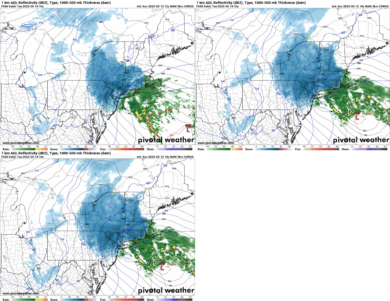
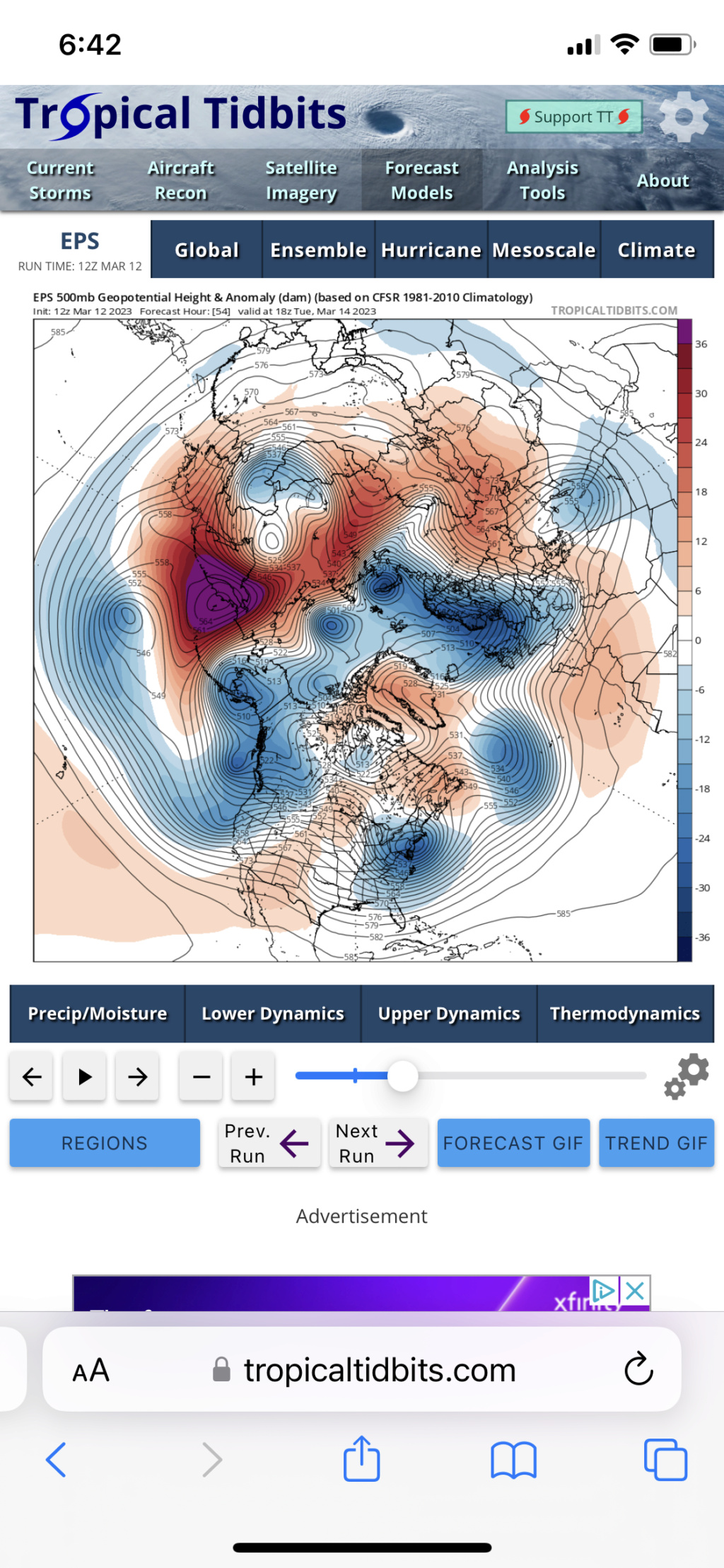
Uhhhh heehaw……very interesting that you just brought that up. What a friggin analog lol
rb924119- Meteorologist

- Posts : 6928
Reputation : 194
Join date : 2013-02-06
Age : 32
Location : Greentown, Pa
rb924119- Meteorologist

- Posts : 6928
Reputation : 194
Join date : 2013-02-06
Age : 32
Location : Greentown, Pa
heehaw453 likes this post
 Re: March 13th-14th "Agita" Storm Part II
I thought this setup looked familiar, but I couldn’t place it haha
rb924119- Meteorologist

- Posts : 6928
Reputation : 194
Join date : 2013-02-06
Age : 32
Location : Greentown, Pa
Page 1 of 15 • 1, 2, 3 ... 8 ... 15 
Page 1 of 15
Permissions in this forum:
You cannot reply to topics in this forum|
|
|

 Home
Home
