March 13th-14th "Agita" Storm Part II
+37
Artingerb
Vinnydula
essexcountypete
DAYBLAZER
brownie
crippo84
2004blackwrx
tomsriversnowstorm
billg315
Scullybutcher
dsix85
aiannone
SENJsnowman
kalleg
sroc4
Radz
phil155
docstox12
1190ftalt
SNOW MAN
TheAresian
hyde345
Dunnzoo
MattyICE
dkodgis
CPcantmeasuresnow
lglickman1
frank 638
rb924119
nutleyblizzard
Coachgriff
amugs
CNWestMilford
weatherwatchermom
jmanley32
heehaw453
Frank_Wx
41 posters
Page 3 of 15
Page 3 of 15 •  1, 2, 3, 4 ... 9 ... 15
 Re: March 13th-14th "Agita" Storm Part II
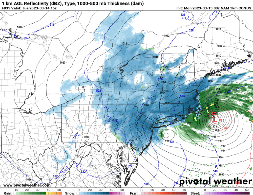
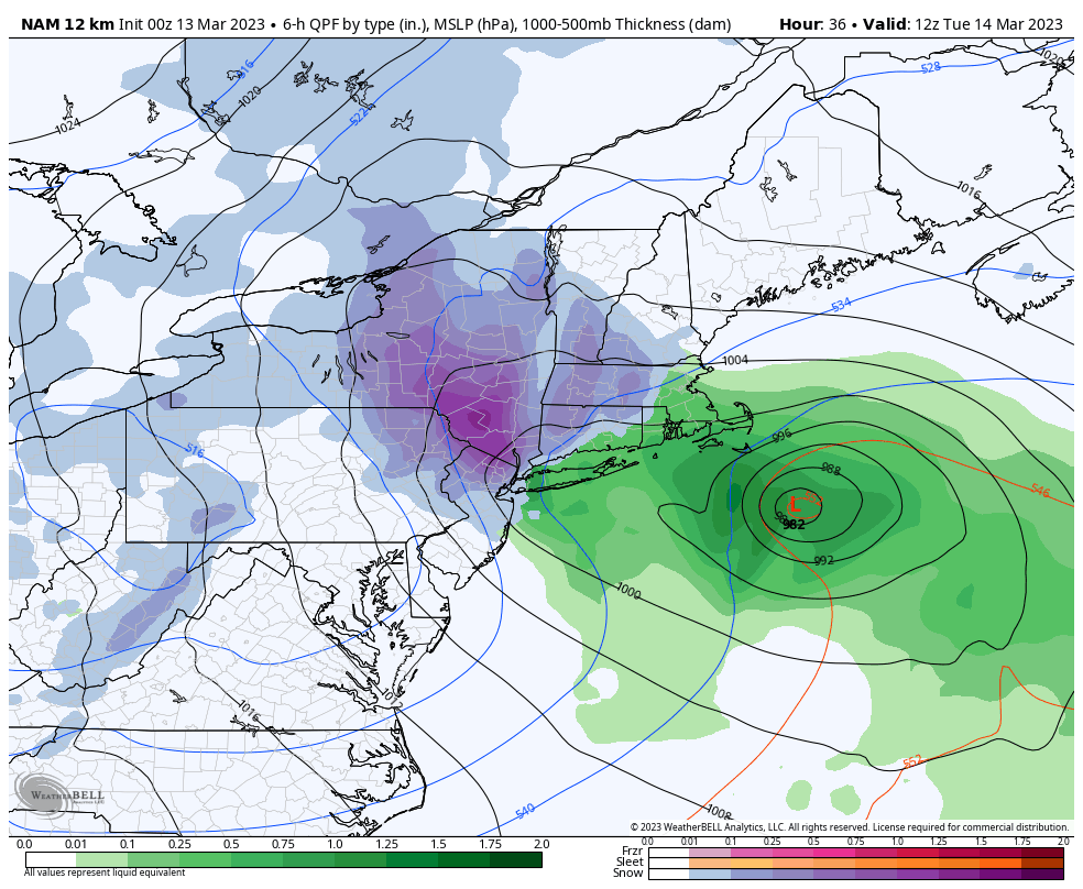
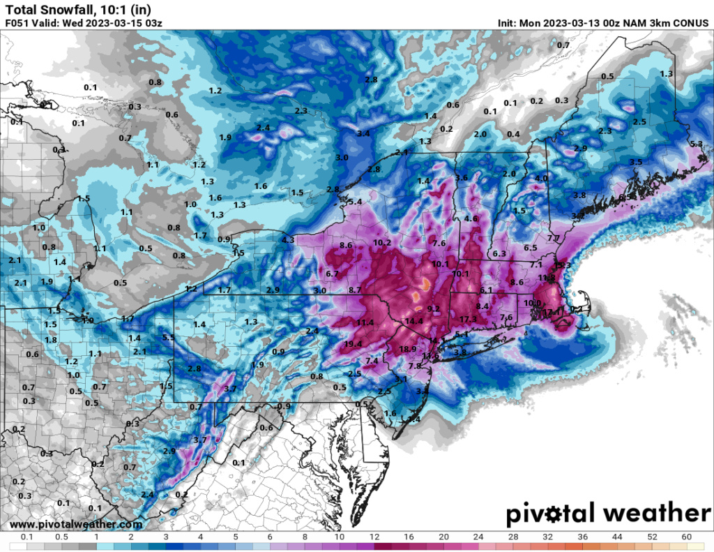
Woah 00z NAM holds serve and is 10mb stronger 974 at 37 hrs, still gives NYC area decent snow, It just doesn't want to let go.
jmanley32- Senior Enthusiast

- Posts : 20535
Join date : 2013-12-12
jmanley32- Senior Enthusiast

- Posts : 20535
Join date : 2013-12-12
 Re: March 13th-14th "Agita" Storm Part II
Just remember it’s not just the GFS but all of the globals against the NAM. The NAM doesn’t even have support from other hi res models. But, it would be quite something to see the EURO tonight go back to showing last nights solution.
_________________
_______________________________________________________________________________________________________
CLICK HERE to view NJ Strong Snowstorm Classifications
docstox12 and CPcantmeasuresnow like this post
heehaw453- Advanced Forecaster

- Posts : 3906
Reputation : 86
Join date : 2014-01-20
Location : Bedminster Township, PA Elevation 600' ASL
 Re: March 13th-14th "Agita" Storm Part II
Stalls for 3 hrs pluss over Cape cod at 968mb, they are going to have a crushing storm, rain and close to hurricane winds if that happens.

jmanley32- Senior Enthusiast

- Posts : 20535
Reputation : 108
Join date : 2013-12-12
Age : 43
Location : Yonkers, NY
 Re: March 13th-14th "Agita" Storm Part II
It's all about having enough time for maturation and consolidation. Can't do that with dilly dally.
heehaw453- Advanced Forecaster

- Posts : 3906
Reputation : 86
Join date : 2014-01-20
Location : Bedminster Township, PA Elevation 600' ASL
 Re: March 13th-14th "Agita" Storm Part II
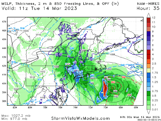
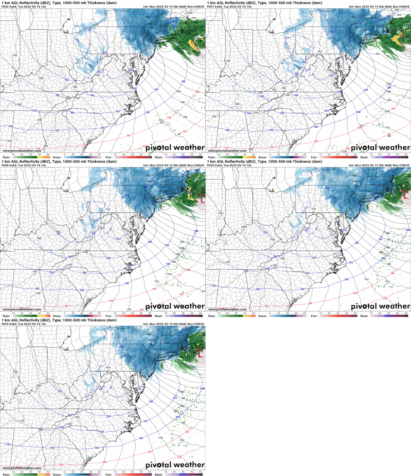
Meso low looks stalled just south of Long Island per latest NAM. IF true, this would deliver snow into NYC

_________________
_______________________________________________________________________________________________________
CLICK HERE to view NJ Strong Snowstorm Classifications
heehaw453 and MattyICE like this post
 Re: March 13th-14th "Agita" Storm Part II
Hi Res Models duo and winds are gonna crank
Sorry who cares about Bastaan this is a different region here. They ate gonna get crushed. This area is what we are trying to reel this in
Sorry who cares about Bastaan this is a different region here. They ate gonna get crushed. This area is what we are trying to reel this in
_________________
Mugs
AKA:King: Snow Weenie
Self Proclaimed
WINTER 2014-15 : 55.12" +.02 for 6 coatings (avg. 35")
WINTER 2015-16 Total - 29.8" (Avg 35")
WINTER 2016-17 : 39.5" so far

amugs- Advanced Forecaster - Mod

- Posts : 15095
Reputation : 213
Join date : 2013-01-07
Age : 54
Location : Hillsdale,NJ
 Re: March 13th-14th "Agita" Storm Part II
The ULL was slightly better than 18Z a bit lower and sharper. Not as good as 12Z. 12Z run is the nirvana.Frank_Wx wrote:Meso low looks stalled just south of Long Island per latest NAM. IF true, this would deliver snow into NYC
heehaw453- Advanced Forecaster

- Posts : 3906
Reputation : 86
Join date : 2014-01-20
Location : Bedminster Township, PA Elevation 600' ASL
 Re: March 13th-14th "Agita" Storm Part II
I just posted above frank the whole system stalls over cape cod for hrs. Even before then shows 10-15 inches IMBY, do I believe it nope. I am inclined to believe your map, it would be quite something to have to drop your snow map 100 miles south lolFrank_Wx wrote:Meso low looks stalled just south of Long Island per latest NAM. IF true, this would deliver snow into NYC
Is the meso stalling because the mail LP stalls? This almost looks like a partial fujiwara.
Last edited by jmanley32 on Sun Mar 12, 2023 10:34 pm; edited 1 time in total

jmanley32- Senior Enthusiast

- Posts : 20535
Reputation : 108
Join date : 2013-12-12
Age : 43
Location : Yonkers, NY
 Re: March 13th-14th "Agita" Storm Part II
See what the 0Z suite has to say.
Let's EURO supports this then now.
Let's EURO supports this then now.
_________________
Mugs
AKA:King: Snow Weenie
Self Proclaimed
WINTER 2014-15 : 55.12" +.02 for 6 coatings (avg. 35")
WINTER 2015-16 Total - 29.8" (Avg 35")
WINTER 2016-17 : 39.5" so far

amugs- Advanced Forecaster - Mod

- Posts : 15095
Reputation : 213
Join date : 2013-01-07
Age : 54
Location : Hillsdale,NJ
 Re: March 13th-14th "Agita" Storm Part II
Well I like cape cod excuse me, didnt say beantown. But yeah this run was wild.amugs wrote:Hi Res Models duo and winds are gonna crank
Sorry who cares about Bastaan this is a different region here. They ate gonna get crushed. This area is what we are trying to reel this in

jmanley32- Senior Enthusiast

- Posts : 20535
Reputation : 108
Join date : 2013-12-12
Age : 43
Location : Yonkers, NY

jmanley32- Senior Enthusiast

- Posts : 20535
Reputation : 108
Join date : 2013-12-12
Age : 43
Location : Yonkers, NY
 Re: March 13th-14th "Agita" Storm Part II
_________________
_______________________________________________________________________________________________________
CLICK HERE to view NJ Strong Snowstorm Classifications
 Re: March 13th-14th "Agita" Storm Part II
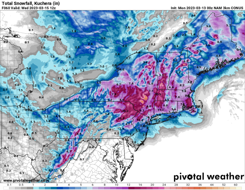
I get that, do any sites offer lower ratios? Well I can tell you I have had snow when NYC has not so there can be ever so slight cut offs, I will remember one night I was driving home from Harlem in puring rain got to yonkers heavy snow.
Still a respectable amount 6-8ish, if the kuchera is correct, about 5:1 or 7:1 as you said.
And thats IF the NAM is right, which I still am very skeptical as you all are. That line of storms coming off the ocean looks like what came off that TS we had, I wonder if we see some intense winds and lightning with that. Please something interesting lol

jmanley32- Senior Enthusiast

- Posts : 20535
Reputation : 108
Join date : 2013-12-12
Age : 43
Location : Yonkers, NY
 Re: March 13th-14th "Agita" Storm Part II
The 3k Nam is on crack. There is no way in hell that NYC is going to get more snow than me 20 miles north of 84. The models have been atrocious with this storm. I could see NYC metro and Long Island in the c-2 range but anything more is highly unlikely.

hyde345- Pro Enthusiast

- Posts : 1082
Reputation : 48
Join date : 2013-01-08
Location : Hyde Park, NY
dkodgis likes this post
 Re: March 13th-14th "Agita" Storm Part II
The beauty of being out of the running on this storm is watching the excitement grow with every passing minute. It's a bit like watching a bunch of Bingo addicts. "I'm this close on this map card. Even closer on that one. That other one is hopeless." Having said that, I'm cheering for all you. It's been a brutal winter and hopefully a lot of you can have it end on a high note.
TheAresian- Senior Enthusiast

- Posts : 145
Reputation : 10
Join date : 2019-11-13
Location : Painted Post, NY
docstox12, essexcountypete and Meepers55 like this post
 Re: March 13th-14th "Agita" Storm Part II
I tell you what we are go need wind headlines if the NAM plays out seeing some sites showing gusts to 50mph and LI 55 and to the "I don't care land of MA 75-95...

jmanley32- Senior Enthusiast

- Posts : 20535
Reputation : 108
Join date : 2013-12-12
Age : 43
Location : Yonkers, NY
 Re: March 13th-14th "Agita" Storm Part II
I am still one letter away from a warning. Two miles away there is one.

dkodgis- Senior Enthusiast

- Posts : 2560
Reputation : 98
Join date : 2013-12-29
 Re: March 13th-14th "Agita" Storm Part II
https://www.weather.gov/media/okx/03122023_pm.pdf
Note the red area stating about the potential for more sig snow into city uncertain, seems like NWS is looking at NAM but not biting yet, is likely go be a nowcast for city and northern suburbs and NE NJ.
Note the red area stating about the potential for more sig snow into city uncertain, seems like NWS is looking at NAM but not biting yet, is likely go be a nowcast for city and northern suburbs and NE NJ.

jmanley32- Senior Enthusiast

- Posts : 20535
Reputation : 108
Join date : 2013-12-12
Age : 43
Location : Yonkers, NY
 Re: March 13th-14th "Agita" Storm Part II
For what little it may be worth, I’m trying to analyze from my phone - I just got to my parents’ place in the Poconos lol I work 11am-9:30pm, in case you were wondering why so late aha
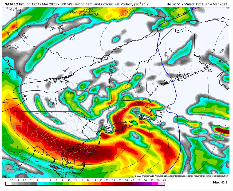
To the point, I’m telling you, DO NOT SLEEP ON THIS IF YOU ARE BETWEEN I-84 and I-78. The more I look at this, the more I see March 2, 2018. Everything is on the EXACT same trajectory. The models are trying to errantly leap frog the main energy to the eastern energy. In my opinion, this is wrong. It’s kind of like putting the cart before the proverbial horse. This storm is developing too-down, not bottom-up. H5 is maturing first, then H7, H850, and finally the surface. This is clearly evident on all models. With that being the case, it makes no sense that all of a sudden the coastal surface low, which is developing IN RESPONSE TO the maturing mid- and low-level cyclones maturing above it FIRST, would start controlling the show. Yes, it will rapidly deepen, but AFTER the cyclones are doing so above it. This evolution has a huge impact on the distribution of precipitation. If you are anywhere north of the H5 trough axis, youre in good shape. Right now, I still stand by what I said earlier. But I am trying to do some further analysis.
To the point, I’m telling you, DO NOT SLEEP ON THIS IF YOU ARE BETWEEN I-84 and I-78. The more I look at this, the more I see March 2, 2018. Everything is on the EXACT same trajectory. The models are trying to errantly leap frog the main energy to the eastern energy. In my opinion, this is wrong. It’s kind of like putting the cart before the proverbial horse. This storm is developing too-down, not bottom-up. H5 is maturing first, then H7, H850, and finally the surface. This is clearly evident on all models. With that being the case, it makes no sense that all of a sudden the coastal surface low, which is developing IN RESPONSE TO the maturing mid- and low-level cyclones maturing above it FIRST, would start controlling the show. Yes, it will rapidly deepen, but AFTER the cyclones are doing so above it. This evolution has a huge impact on the distribution of precipitation. If you are anywhere north of the H5 trough axis, youre in good shape. Right now, I still stand by what I said earlier. But I am trying to do some further analysis.
rb924119- Meteorologist

- Posts : 6928
Reputation : 194
Join date : 2013-02-06
Age : 32
Location : Greentown, Pa
docstox12, CPcantmeasuresnow, kalleg and 1190ftalt like this post
 Re: March 13th-14th "Agita" Storm Part II
In my opinion, the NAM makes the most synoptic sense right now.
rb924119- Meteorologist

- Posts : 6928
Reputation : 194
Join date : 2013-02-06
Age : 32
Location : Greentown, Pa
docstox12 and CPcantmeasuresnow like this post
 Re: March 13th-14th "Agita" Storm Part II
I wish I had my computer here so I could make a video to explain myself, but the internet here is so slow you all wouldn’t see it until after whatever is going to happen happens aha it would take until next March to render 

rb924119- Meteorologist

- Posts : 6928
Reputation : 194
Join date : 2013-02-06
Age : 32
Location : Greentown, Pa
SENJsnowman likes this post
 Re: March 13th-14th "Agita" Storm Part II
rb924119 wrote:For what little it may be worth, I’m trying to analyze from my phone - I just got to my parents’ place in the Poconos lol I work 11am-9:30pm, in case you were wondering why so late aha
To the point, I’m telling you, DO NOT SLEEP ON THIS IF YOU ARE BETWEEN I-84 and I-78. The more I look at this, the more I see March 2, 2018. Everything is on the EXACT same trajectory. The models are trying to errantly leap frog the main energy to the eastern energy. In my opinion, this is wrong. It’s kind of like putting the cart before the proverbial horse. This storm is developing too-down, not bottom-up. H5 is maturing first, then H7, H850, and finally the surface. This is clearly evident on all models. With that being the case, it makes no sense that all of a sudden the coastal surface low, which is developing IN RESPONSE TO the maturing mid- and low-level cyclones maturing above it FIRST, would start controlling the show. Yes, it will rapidly deepen, but AFTER the cyclones are doing so above it. This evolution has a huge impact on the distribution of precipitation. If you are anywhere north of the H5 trough axis, youre in good shape. Right now, I still stand by what I said earlier. But I am trying to do some further analysis.
rb I think your going to be correct. The NWS has put my area in a WSW for 12-18 inches of snow with higher amounts possible in the higher elevations. I'm in Marshalls Creek PA. just below where your parents live.

SNOW MAN- Senior Enthusiast

- Posts : 1361
Reputation : 25
Join date : 2013-01-13
Age : 64
Location : Marshalls Creek Pa.
docstox12 likes this post

1190ftalt- Pro Enthusiast

- Posts : 401
Reputation : 10
Join date : 2013-12-13
Location : Stillwater, NJ
1190ftalt and weatherwatchermom like this post
 Re: March 13th-14th "Agita" Storm Part II
SNOW MAN wrote:rb924119 wrote:For what little it may be worth, I’m trying to analyze from my phone - I just got to my parents’ place in the Poconos lol I work 11am-9:30pm, in case you were wondering why so late aha
To the point, I’m telling you, DO NOT SLEEP ON THIS IF YOU ARE BETWEEN I-84 and I-78. The more I look at this, the more I see March 2, 2018. Everything is on the EXACT same trajectory. The models are trying to errantly leap frog the main energy to the eastern energy. In my opinion, this is wrong. It’s kind of like putting the cart before the proverbial horse. This storm is developing too-down, not bottom-up. H5 is maturing first, then H7, H850, and finally the surface. This is clearly evident on all models. With that being the case, it makes no sense that all of a sudden the coastal surface low, which is developing IN RESPONSE TO the maturing mid- and low-level cyclones maturing above it FIRST, would start controlling the show. Yes, it will rapidly deepen, but AFTER the cyclones are doing so above it. This evolution has a huge impact on the distribution of precipitation. If you are anywhere north of the H5 trough axis, youre in good shape. Right now, I still stand by what I said earlier. But I am trying to do some further analysis.
rb I think your going to be correct. The NWS has put my area in a WSW for 12-18 inches of snow with higher amounts possible in the higher elevations. I'm in Marshalls Creek PA. just below where your parents live.
Snow Man, good to see ya, brother!! Thanks for the support! I have a 50-50 shot haha
As I continue analyze this, here’s what I’m thinking:
1. We see a sharper height field out ahead of our approaching mid-level cyclone as a result of increased latent heat release from the relatively “warmer” ocean coupled with offshore convection.
2. A slightly southward displacement of the cyclonic evolution based on hemispheric and tropical forcing mechanisms. It won’t be by much, maybe 25-50 miles, but I do think it happens.
As a result of these two in things, I think we will see an overall more robust/earlier/more efficient consolidation of energies and maturation versus what is being currently modeled. Therefore, an enhancement of the forcing mechanisms in play the same ones I mentioned earlier yesterday) should be realized at game time, with a further southwestward displacement of snowfall.
rb924119- Meteorologist

- Posts : 6928
Reputation : 194
Join date : 2013-02-06
Age : 32
Location : Greentown, Pa
 Re: March 13th-14th "Agita" Storm Part II
36 degrees, cloudy, drizzle calm winds.Upgraded to warning here , anywhere between 4 to 12 inches, higher amounts 500 to 750 feet.I am over 500 feet.Nowcast time, any wobbles can make a difference either way .
7:01 Just checked, elevation of Monroe NY 636 feet.
7:01 Just checked, elevation of Monroe NY 636 feet.
Last edited by docstox12 on Mon Mar 13, 2023 7:01 am; edited 1 time in total

docstox12- Wx Statistician Guru

- Posts : 8530
Reputation : 222
Join date : 2013-01-07
Age : 73
Location : Monroe NY
Page 3 of 15 •  1, 2, 3, 4 ... 9 ... 15
Page 3 of 15
Permissions in this forum:
You cannot reply to topics in this forum|
|
|

 Home
Home