
 Search
March 13th-14th "Agita" Storm Part II
Page 6 of 15 •  1 ... 5, 6, 7 ... 10 ... 15
 ![]()
Re: March 13th-14th "Agita" Storm Part II
![]() by lglickman1 Mon Mar 13, 2023 1:13 pm
by lglickman1 Mon Mar 13, 2023 1:13 pm
Scullybutcher wrote:anytime people rely on backend snow and storms stalling they are usually disappointedsroc4 wrote:dsix85 wrote:@ Sroc-can we start to get a tad bit excited out in Manorville/Wading River?
That's my experience too. How far west will this back end snow potentially extend if it happens?
I cant get excited yet. Its likely going to be a nowcast situation. Will have to watch how the low and meso low all behaves and see how the back end snow bands develop and where they develop as the system matures.
lglickman1- Pro Enthusiast

- Posts : 319
Join date : 2013-02-05
Re: March 13th-14th "Agita" Storm Part II
![]() by sroc4 Mon Mar 13, 2023 1:14 pm
by sroc4 Mon Mar 13, 2023 1:14 pm
Scullybutcher wrote:anytime people rely on backend snow and storms stalling they are usually disappointedsroc4 wrote:dsix85 wrote:@ Sroc-can we start to get a tad bit excited out in Manorville/Wading River?
I cant get excited yet. Its likely going to be a nowcast situation. Will have to watch how the low and meso low all behaves and see how the back end snow bands develop and where they develop as the system matures.
At least there is definite blocking Scully so there there will be a maturing CCB developing and the Low will stall nd even retrograde some. Its a matter of whether or not the southern energy is too far east or a tad closer to the coast to interact with the energy in the trough later vs sooner. If sooner like the Nam we are in the game in Suffolk county. If later...oogatz I wont hold my breath, but will watch closely.
sroc4- Admin

- Posts : 8354
Join date : 2013-01-07
Scullybutcher likes this post
Re: March 13th-14th "Agita" Storm Part II
![]() by heehaw453 Mon Mar 13, 2023 1:22 pm
by heehaw453 Mon Mar 13, 2023 1:22 pm
Yeah doc. one could argue Miller A since there's already a storm emanating from the gulf. I think in a truer sense since this depends so heavily on consolidation for deepening between two disparate s/w's it's more of a Miller B setup. By itself the coastal energy is benign and it's only until it meets up with trailing s/w that it starts to deepen.docstox12 wrote:heehaw453 wrote:Anytime we see Miller B setups look to I90 corridor ALB-->Berkshires-->Worcester for jackpot. BOS only if it's cold enough which it's not. We see this time and time again.
Ugh, Miller B's, never like them.
I thought this coming storm was going to be a Miller A, but apparently, I was off on that.The March 1993 was a Miller A coming right up the coast.Too bad for my location in Mahwah NJ, it mixed with sleet and there was 17 inches, 3 inches of which on top was sleet.Out by NE PA, they had 36 inches.
heehaw453- Advanced Forecaster

- Posts : 3906
Reputation : 86
Join date : 2014-01-20
Location : Bedminster Township, PA Elevation 600' ASL
Re: March 13th-14th "Agita" Storm Part II
![]() by billg315 Mon Mar 13, 2023 1:31 pm
by billg315 Mon Mar 13, 2023 1:31 pm
So typical of this winter. We finally get a Miller A and it decides to dress up as a Miller B; and a hideous one at that.heehaw453 wrote:Yeah doc. one could argue Miller A since there's already a storm emanating from the gulf. I think in a truer sense since this depends so heavily on consolidation for deepening between two disparate s/w's it's more of a Miller B setup. By itself the coastal energy is benign and it's only until it meets up with trailing s/w that it starts to deepen.docstox12 wrote:heehaw453 wrote:Anytime we see Miller B setups look to I90 corridor ALB-->Berkshires-->Worcester for jackpot. BOS only if it's cold enough which it's not. We see this time and time again.
Ugh, Miller B's, never like them.
I thought this coming storm was going to be a Miller A, but apparently, I was off on that.The March 1993 was a Miller A coming right up the coast.Too bad for my location in Mahwah NJ, it mixed with sleet and there was 17 inches, 3 inches of which on top was sleet.Out by NE PA, they had 36 inches.

billg315- Advanced Forecaster - Mod

- Posts : 4483
Reputation : 185
Join date : 2015-01-24
Age : 50
Location : Flemington, NJ
CPcantmeasuresnow and heehaw453 like this post
Re: March 13th-14th "Agita" Storm Part II
![]() by heehaw453 Mon Mar 13, 2023 2:08 pm
by heehaw453 Mon Mar 13, 2023 2:08 pm


heehaw453- Advanced Forecaster
- Posts : 3906
Reputation : 86
Join date : 2014-01-20
Location : Bedminster Township, PA Elevation 600' ASL
moleson and kalleg like this post
Re: March 13th-14th "Agita" Storm Part II
![]() by rb924119 Mon Mar 13, 2023 2:30 pm
by rb924119 Mon Mar 13, 2023 2:30 pm

I’m not giving up on this. If I’m wrong then so be it. But right now, I like what I’m seeing on radar and satellite imagery.
rb924119- Meteorologist

- Posts : 6928
Reputation : 194
Join date : 2013-02-06
Age : 32
Location : Greentown, Pa
Re: March 13th-14th "Agita" Storm Part II
![]() by heehaw453 Mon Mar 13, 2023 2:42 pm
by heehaw453 Mon Mar 13, 2023 2:42 pm
Still remember measuring a 20" spot in Barnegat after your call of the legendary January 2022 pattern evolution. Case study type of thing IMO. I'm heading out to Monticello in a few hours. I fully expect at least 1' after it flips to snow this evening. Just not sure about NEPA right now?rb924119 wrote:Playing contrarian here, we should start to see the radar fill in now. The red line looks to me to be the back edge associated with the backing mid-level flows (H7 and H5). The yellow line is my estimation of the back edge of the precipitation being forced by the lower-levels H85 and below). The blue line is the back edge that I’m expecting to see emerge over the next several hours. Then as the whole system progresses, some northward progression of the back edge is expected, but it should pivot more than just lift up/out. Will be fun to test this.
I’m not giving up on this. If I’m wrong then so be it. But right now, I like what I’m seeing on radar and satellite imagery.
heehaw453- Advanced Forecaster
- Posts : 3906
Reputation : 86
Join date : 2014-01-20
Location : Bedminster Township, PA Elevation 600' ASL
rb924119 likes this post
Re: March 13th-14th "Agita" Storm Part II
![]() by MattyICE Mon Mar 13, 2023 2:50 pm
by MattyICE Mon Mar 13, 2023 2:50 pm
heehaw453 wrote:Still remember measuring a 20" spot in Barnegat after your call of the legendary January 2022 pattern evolution. Case study type of thing IMO. I'm heading out to Monticello in a few hours. I fully expect at least 1' after it flips to snow this evening. Just not sure about NEPA right now?rb924119 wrote:Playing contrarian here, we should start to see the radar fill in now. The red line looks to me to be the back edge associated with the backing mid-level flows (H7 and H5). The yellow line is my estimation of the back edge of the precipitation being forced by the lower-levels H85 and below). The blue line is the back edge that I’m expecting to see emerge over the next several hours. Then as the whole system progresses, some northward progression of the back edge is expected, but it should pivot more than just lift up/out. Will be fun to test this.
[url=https://servimg.com/view/19130284/596][/url
I’m not giving up on this. If I’m wrong then so be it. But right now, I like what I’m seeing on radar and satellite imagery.
I can attest to how amazing he was in I think dec 2020 when he insisted it was a Binghamton jackpot rather than just NW of 95. Sure enough models had be at 2-3x what I got and it played out exactly as he cautioned
Last edited by MattyICE on Mon Mar 13, 2023 2:51 pm; edited 1 time in total
MattyICE- Advanced Forecaster
- Posts : 249
Reputation : 6
Join date : 2017-11-10
Age : 38
Location : Clifton, NJ (Eastern Passaic County)
rb924119 likes this post
Re: March 13th-14th "Agita" Storm Part II
![]() by jmanley32 Mon Mar 13, 2023 2:50 pm
by jmanley32 Mon Mar 13, 2023 2:50 pm

jmanley32- Senior Enthusiast

- Posts : 20535
Reputation : 108
Join date : 2013-12-12
Age : 43
Location : Yonkers, NY
Re: March 13th-14th "Agita" Storm Part II
![]() by docstox12 Mon Mar 13, 2023 2:51 pm
by docstox12 Mon Mar 13, 2023 2:51 pm
heehaw453 wrote:Still remember measuring a 20" spot in Barnegat after your call of the legendary January 2022 pattern evolution. Case study type of thing IMO. I'm heading out to Monticello in a few hours. I fully expect at least 1' after it flips to snow this evening. Just not sure about NEPA right now?rb924119 wrote:Playing contrarian here, we should start to see the radar fill in now. The red line looks to me to be the back edge associated with the backing mid-level flows (H7 and H5). The yellow line is my estimation of the back edge of the precipitation being forced by the lower-levels H85 and below). The blue line is the back edge that I’m expecting to see emerge over the next several hours. Then as the whole system progresses, some northward progression of the back edge is expected, but it should pivot more than just lift up/out. Will be fun to test this.
I’m not giving up on this. If I’m wrong then so be it. But right now, I like what I’m seeing on radar and satellite imagery.
Consider Roscoe NY and the Roscoe Motel.There is also the Reynolds House as well.They should do better than Monticello and you have Raimondos, a great Italian Restaurant and the "famous" Roscoe Diner for good breakfasts.Spent many a day and night up there trout fishing the Beaverkill River.Some of the happiest times of my life up there.

docstox12- Wx Statistician Guru

- Posts : 8530
Reputation : 222
Join date : 2013-01-07
Age : 73
Location : Monroe NY
heehaw453 likes this post
Re: March 13th-14th "Agita" Storm Part II
![]() by jmanley32 Mon Mar 13, 2023 2:52 pm
by jmanley32 Mon Mar 13, 2023 2:52 pm
jmanley32- Senior Enthusiast
- Posts : 20535
Reputation : 108
Join date : 2013-12-12
Age : 43
Location : Yonkers, NY
Re: March 13th-14th "Agita" Storm Part II
![]() by TheAresian Mon Mar 13, 2023 2:54 pm
by TheAresian Mon Mar 13, 2023 2:54 pm
TheAresian- Senior Enthusiast
- Posts : 145
Reputation : 10
Join date : 2019-11-13
Location : Painted Post, NY
CPcantmeasuresnow likes this post
Re: March 13th-14th "Agita" Storm Part II
![]() by Dunnzoo Mon Mar 13, 2023 3:04 pm
by Dunnzoo Mon Mar 13, 2023 3:04 pm
jmanley32 wrote:Any chances for NYC area and southern westchester or are we as has been said past few hours ogatz? I see NW NJ is now in WSW, lucky. mugs that's you and dunzoo right?
jman, mugs and I are in NENJ, in Bergen County near the NYS border. We don't even have the hazardous weather outlook anymore
_________________
Janet
Snowfall winter of 2023-2024 17.5"
Snowfall winter of 2022-2023 6.0"
Snowfall winter of 2021-2022 17.6" 1" sleet 2/25/22
Snowfall winter of 2020-2021 51.1"
Snowfall winter of 2019-2020 8.5"
Snowfall winter of 2018-2019 25.1"
Snowfall winter of 2017-2018 51.9"
Snowfall winter of 2016-2017 45.6"
Snowfall winter of 2015-2016 29.5"
Snowfall winter of 2014-2015 50.55"
Snowfall winter of 2013-2014 66.5"

Dunnzoo- Senior Enthusiast - Mod
- Posts : 4905
Reputation : 68
Join date : 2013-01-11
Age : 62
Location : Westwood, NJ
Re: March 13th-14th "Agita" Storm Part II
![]() by jmanley32 Mon Mar 13, 2023 3:11 pm
by jmanley32 Mon Mar 13, 2023 3:11 pm
HWO lol, always means nada to me. Guess that means I am likely out of it too. Ho hum.Dunnzoo wrote:jmanley32 wrote:Any chances for NYC area and southern westchester or are we as has been said past few hours ogatz? I see NW NJ is now in WSW, lucky. mugs that's you and dunzoo right?
jman, mugs and I are in NENJ, in Bergen County near the NYS border. We don't even have the hazardous weather outlook anymore
jmanley32- Senior Enthusiast
- Posts : 20535
Reputation : 108
Join date : 2013-12-12
Age : 43
Location : Yonkers, NY
Re: March 13th-14th "Agita" Storm Part II
![]() by amugs Mon Mar 13, 2023 3:29 pm
by amugs Mon Mar 13, 2023 3:29 pm
Wx Geek Post! Plot of current Theta-E advection. :point_down: It's "potential energy". Nor'Easters like Theta-E. The storm (Red X) will likely follow that path. It's a little closer to the coast than most modeling. Upstream impact? 🤨 Maybe! Stay tuned. :snowflake::steam_locomotive: pic.twitter.com/npVEfe3Lk0
— Tony Pann (@TonyPannWBAL) March 13, 2023
_________________
Mugs
AKA:King: Snow Weenie
Self Proclaimed
WINTER 2014-15 : 55.12" +.02 for 6 coatings (avg. 35")
WINTER 2015-16 Total - 29.8" (Avg 35")
WINTER 2016-17 : 39.5" so far

amugs- Advanced Forecaster - Mod
- Posts : 15095
Reputation : 213
Join date : 2013-01-07
Age : 54
Location : Hillsdale,NJ
Re: March 13th-14th "Agita" Storm Part II
![]() by SENJsnowman Mon Mar 13, 2023 3:38 pm
by SENJsnowman Mon Mar 13, 2023 3:38 pm
amugs wrote:Wx Geek Post! Plot of current Theta-E advection. :point_down: It's "potential energy". Nor'Easters like Theta-E. The storm (Red X) will likely follow that path. It's a little closer to the coast than most modeling. Upstream impact? 🤨 Maybe! Stay tuned. :snowflake::steam_locomotive: pic.twitter.com/npVEfe3Lk0
— Tony Pann (@TonyPannWBAL) March 13, 2023
Hmmm…I wonder if coastal Ocean and Monmouth stand to benefit from that…it would seem so. I’d have to think that would benefit W LI and NYC immediate suburbs the most…but, we’ll see.
And is this consistent with Rbs posting earlier about the precip re-orienting?
Interesting to say the least…
SENJsnowman- Senior Enthusiast
- Posts : 1189
Reputation : 61
Join date : 2017-01-06
Age : 51
Location : Bayville, NJ
Re: March 13th-14th "Agita" Storm Part II
![]() by jmanley32 Mon Mar 13, 2023 3:48 pm
by jmanley32 Mon Mar 13, 2023 3:48 pm
Can someone explain this to me? The X will ride along the purple lines? And this will allow for some surprise snow for NYC suburbs?SENJsnowman wrote:amugs wrote:Wx Geek Post! Plot of current Theta-E advection. :point_down: It's "potential energy". Nor'Easters like Theta-E. The storm (Red X) will likely follow that path. It's a little closer to the coast than most modeling. Upstream impact? 🤨 Maybe! Stay tuned. :snowflake::steam_locomotive: pic.twitter.com/npVEfe3Lk0
— Tony Pann (@TonyPannWBAL) March 13, 2023
Hmmm…I wonder if coastal Ocean and Monmouth stand to benefit from that…it would seem so. I’d have to think that would benefit W LI and NYC immediate suburbs the most…but, we’ll see.
And is this consistent with Rbs posting earlier about the precip re-orienting?
Interesting to say the least…
jmanley32- Senior Enthusiast
- Posts : 20535
Reputation : 108
Join date : 2013-12-12
Age : 43
Location : Yonkers, NY
Re: March 13th-14th "Agita" Storm Part II
![]() by SENJsnowman Mon Mar 13, 2023 3:51 pm
by SENJsnowman Mon Mar 13, 2023 3:51 pm
Any one else care to weigh in on this and correct me if I am wrong (which is obviously most likely the case anyways).
SENJsnowman- Senior Enthusiast
- Posts : 1189
Reputation : 61
Join date : 2017-01-06
Age : 51
Location : Bayville, NJ
Re: March 13th-14th "Agita" Storm Part II
![]() by sroc4 Mon Mar 13, 2023 3:57 pm
by sroc4 Mon Mar 13, 2023 3:57 pm
jmanley32 wrote:Can someone explain this to me? The X will ride along the purple lines? And this will allow for some surprise snow for NYC suburbs?SENJsnowman wrote:amugs wrote:Wx Geek Post! Plot of current Theta-E advection. :point_down: It's "potential energy". Nor'Easters like Theta-E. The storm (Red X) will likely follow that path. It's a little closer to the coast than most modeling. Upstream impact? 🤨 Maybe! Stay tuned. :snowflake::steam_locomotive: pic.twitter.com/npVEfe3Lk0
— Tony Pann (@TonyPannWBAL) March 13, 2023
Hmmm…I wonder if coastal Ocean and Monmouth stand to benefit from that…it would seem so. I’d have to think that would benefit W LI and NYC immediate suburbs the most…but, we’ll see.
And is this consistent with Rbs posting earlier about the precip re-orienting?
Interesting to say the least…
If it follows the theta contours I outlined with the yellow arrow it heads east like most modeling has it. If it follows the theta more northernly like he is stating then maybe surprises...and dont ask about surprises in your back yard...just surprises. It sounds like Tony is reaching to me.

_________________
"In weather and in life, there's no winning and losing; there's only winning and learning."
WINTER 2012/2013 TOTALS 43.65"WINTER 2017/2018 TOTALS 62.85" WINTER 2022/2023 TOTALS 4.9"
WINTER 2013/2014 TOTALS 64.85"WINTER 2018/2019 TOTALS 14.25" WINTER 2023/2024 TOTALS 13.1"
WINTER 2014/2015 TOTALS 71.20"WINTER 2019/2020 TOTALS 6.35"
WINTER 2015/2016 TOTALS 35.00"WINTER 2020/2021 TOTALS 37.75"
WINTER 2016/2017 TOTALS 42.25"WINTER 2021/2022 TOTALS 31.65"

sroc4- Admin
- Posts : 8354
Reputation : 302
Join date : 2013-01-07
Location : Wading River, LI
Re: March 13th-14th "Agita" Storm Part II
![]() by heehaw453 Mon Mar 13, 2023 4:02 pm
by heehaw453 Mon Mar 13, 2023 4:02 pm

heehaw453- Advanced Forecaster
- Posts : 3906
Reputation : 86
Join date : 2014-01-20
Location : Bedminster Township, PA Elevation 600' ASL
Re: March 13th-14th "Agita" Storm Part II
![]() by docstox12 Mon Mar 13, 2023 4:03 pm
by docstox12 Mon Mar 13, 2023 4:03 pm
SENJsnowman wrote:Jman, if I am correctly following what Tony said, it would shift the n/s axis of the wrap-around snow east by as much as 100 miles. And that would favor your latitude I think pretty well.
Any one else care to weigh in on this and correct me if I am wrong (which is obviously most likely the case anyways).
I can't say technically SE, but these big storms can throw crazy curve balls , good or bad for an area,as they are happening so stay tuned!!!
docstox12- Wx Statistician Guru
- Posts : 8530
Reputation : 222
Join date : 2013-01-07
Age : 73
Location : Monroe NY
SENJsnowman likes this post
Re: March 13th-14th "Agita" Storm Part II
![]() by jmanley32 Mon Mar 13, 2023 4:21 pm
by jmanley32 Mon Mar 13, 2023 4:21 pm
So IYBY not mine lolsroc4 wrote:jmanley32 wrote:Can someone explain this to me? The X will ride along the purple lines? And this will allow for some surprise snow for NYC suburbs?SENJsnowman wrote:amugs wrote:Wx Geek Post! Plot of current Theta-E advection. :point_down: It's "potential energy". Nor'Easters like Theta-E. The storm (Red X) will likely follow that path. It's a little closer to the coast than most modeling. Upstream impact? 🤨 Maybe! Stay tuned. :snowflake::steam_locomotive: pic.twitter.com/npVEfe3Lk0
— Tony Pann (@TonyPannWBAL) March 13, 2023
Hmmm…I wonder if coastal Ocean and Monmouth stand to benefit from that…it would seem so. I’d have to think that would benefit W LI and NYC immediate suburbs the most…but, we’ll see.
And is this consistent with Rbs posting earlier about the precip re-orienting?
Interesting to say the least…
If it follows the theta contours I outlined with the yellow arrow it heads east like most modeling has it. If it follows the theta more northernly like he is stating then maybe surprises...and dont ask about surprises in your back yard...just surprises. It sounds like Tony is reaching to me.
jmanley32- Senior Enthusiast
- Posts : 20535
Reputation : 108
Join date : 2013-12-12
Age : 43
Location : Yonkers, NY
Re: March 13th-14th "Agita" Storm Part II
![]() by Frank_Wx Mon Mar 13, 2023 4:58 pm
by Frank_Wx Mon Mar 13, 2023 4:58 pm
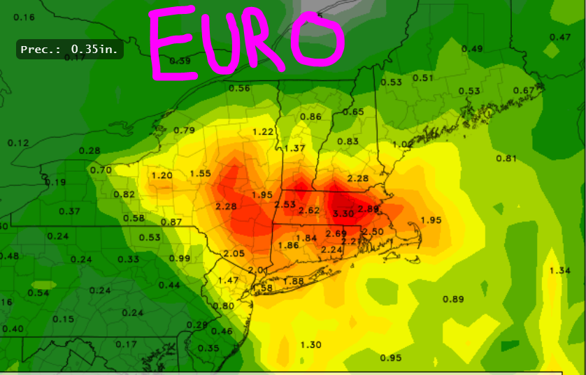
Now look at todays 12z EURO:
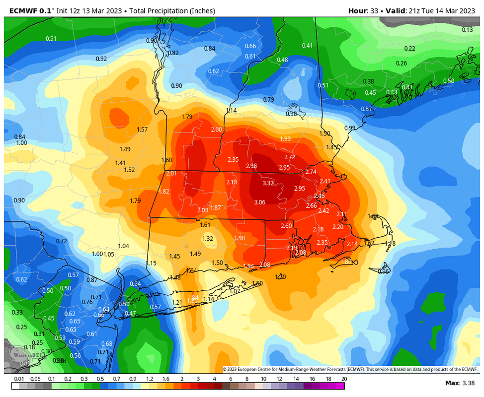
Everything has shifted NNE. New snow map coming shortly...
_________________
_______________________________________________________________________________________________________
CLICK HERE to view NJ Strong Snowstorm Classifications

Frank_Wx- Godzilla Seeker
- Posts : 21305
Reputation : 328
Join date : 2013-01-05
Age : 32
Location : Jersey City, NJ -

Re: March 13th-14th "Agita" Storm Part II
![]() by jmanley32 Mon Mar 13, 2023 5:06 pm
by jmanley32 Mon Mar 13, 2023 5:06 pm
Wow not even a half inch rain for NYC area, if it was going to be all rain I would rather very little. Thats kind of a funny little cut out there. How much can we believe the LR models at this point, what does HRRR show? I have been too busy to look at models. I know your map won't give me anything but am interested to see where its going and I think I know.Frank_Wx wrote:Remember where EURO and GFS had the heaviest axis of precipitation yesterday? Here is a reminder:
Now look at todays 12z EURO:
Everything has shifted NNE. New snow map coming shortly...
jmanley32- Senior Enthusiast
- Posts : 20535
Reputation : 108
Join date : 2013-12-12
Age : 43
Location : Yonkers, NY
Re: March 13th-14th "Agita" Storm Part II
![]() by jmanley32 Mon Mar 13, 2023 5:11 pm
by jmanley32 Mon Mar 13, 2023 5:11 pm
jmanley32- Senior Enthusiast
- Posts : 20535
Reputation : 108
Join date : 2013-12-12
Age : 43
Location : Yonkers, NY
Re: March 13th-14th "Agita" Storm Part II
![]() by SENJsnowman Mon Mar 13, 2023 5:13 pm
by SENJsnowman Mon Mar 13, 2023 5:13 pm
SENJsnowman- Senior Enthusiast
- Posts : 1189
Reputation : 61
Join date : 2017-01-06
Age : 51
Location : Bayville, NJ
Re: March 13th-14th "Agita" Storm Part II
![]() by SENJsnowman Mon Mar 13, 2023 5:17 pm
by SENJsnowman Mon Mar 13, 2023 5:17 pm
SENJsnowman- Senior Enthusiast
- Posts : 1189
Reputation : 61
Join date : 2017-01-06
Age : 51
Location : Bayville, NJ
Page 6 of 15 • 1 ... 5, 6, 7 ... 10 ... 15 ![]()
|
|
|