March 13th-14th "Agita" Storm Part II
+37
Artingerb
Vinnydula
essexcountypete
DAYBLAZER
brownie
crippo84
2004blackwrx
tomsriversnowstorm
billg315
Scullybutcher
dsix85
aiannone
SENJsnowman
kalleg
sroc4
Radz
phil155
docstox12
1190ftalt
SNOW MAN
TheAresian
hyde345
Dunnzoo
MattyICE
dkodgis
CPcantmeasuresnow
lglickman1
frank 638
rb924119
nutleyblizzard
Coachgriff
amugs
CNWestMilford
weatherwatchermom
jmanley32
heehaw453
Frank_Wx
41 posters
Page 5 of 15
Page 5 of 15 •  1, 2, 3, 4, 5, 6 ... 10 ... 15
 Re: March 13th-14th "Agita" Storm Part II
The atmospheric streamflow is already beginning to reorient itself, as can be seen by the development of parallel banding features and their subsequent motion on radar.
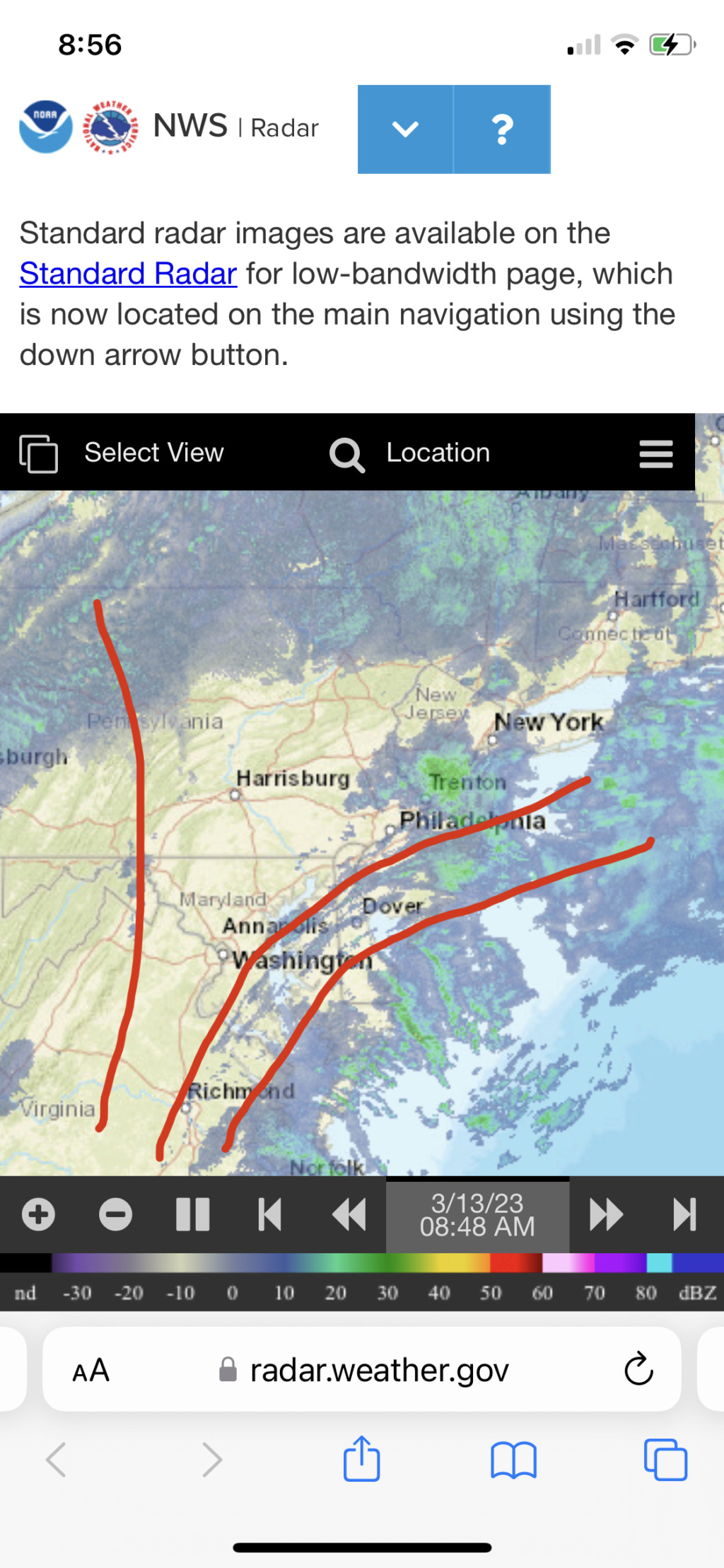
This is why the precip field is filling on radar - you’re beginning to see the atmosphere “spread apart” in response to the forcing mechanisms in play creating forcing for ascent. Strictly anecdotally, whenever I’ve seen precipitation falling well in advance of a storm, it’s always boded well. At least in my recent working memory, which admittedly, is not all that long haha

This is why the precip field is filling on radar - you’re beginning to see the atmosphere “spread apart” in response to the forcing mechanisms in play creating forcing for ascent. Strictly anecdotally, whenever I’ve seen precipitation falling well in advance of a storm, it’s always boded well. At least in my recent working memory, which admittedly, is not all that long haha
rb924119- Meteorologist

- Posts : 6928
Join date : 2013-02-06
heehaw453 likes this post
SENJsnowman- Senior Enthusiast

- Posts : 1189
Join date : 2017-01-06
docstox12 and CPcantmeasuresnow like this post
 Re: March 13th-14th "Agita" Storm Part II
LOL,SE, I stuck it up the NAM model where the sun don't shine.

docstox12- Wx Statistician Guru

- Posts : 8530
Reputation : 222
Join date : 2013-01-07
Age : 73
Location : Monroe NY
CPcantmeasuresnow, billg315 and SENJsnowman like this post
 Re: March 13th-14th "Agita" Storm Part II
Frank_Wx wrote:NAM lost the meso low last night. We now have model consensus, though I can see why Ray feels they are lost. We’ll just have to wait and see.
Central NY and southern NE are going to get slammed with some pretty wet snow. Could be a dangerous situation in some parts. I’ll have an updated snow map this afternoon.
I see where Central NY can get slammed, even parts of SE NY like the Catskills, but I'm not seeing at all where southern New England does.
Looks like a wind driven rainstorm for most of CT except the higher terrain and NW corner, all of RI and eastern Massachusetts.

CPcantmeasuresnow- Wx Statistician Guru

- Posts : 7274
Reputation : 230
Join date : 2013-01-07
Age : 103
Location : Eastern Orange County, NY
 Re: March 13th-14th "Agita" Storm Part II
NAM trying to SUCK ME BACK IN!!! 
_________________
"In weather and in life, there's no winning and losing; there's only winning and learning."
WINTER 2012/2013 TOTALS 43.65"WINTER 2017/2018 TOTALS 62.85" WINTER 2022/2023 TOTALS 4.9"
WINTER 2013/2014 TOTALS 64.85"WINTER 2018/2019 TOTALS 14.25" WINTER 2023/2024 TOTALS 13.1"
WINTER 2014/2015 TOTALS 71.20"WINTER 2019/2020 TOTALS 6.35"
WINTER 2015/2016 TOTALS 35.00"WINTER 2020/2021 TOTALS 37.75"
WINTER 2016/2017 TOTALS 42.25"WINTER 2021/2022 TOTALS 31.65"

sroc4- Admin

- Posts : 8354
Reputation : 302
Join date : 2013-01-07
Location : Wading River, LI
 Re: March 13th-14th "Agita" Storm Part II
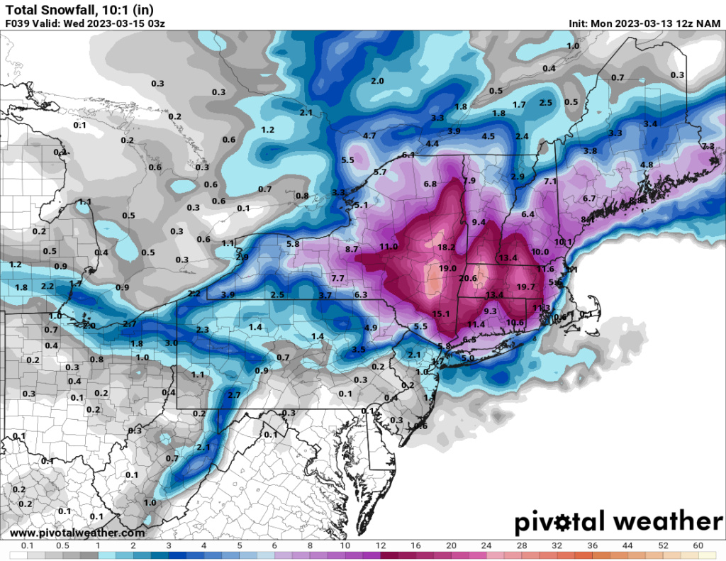
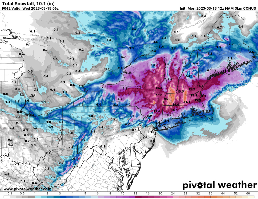
The difference between the 12k NAM and 3K NAM at 500 is laughable.
_________________
"In weather and in life, there's no winning and losing; there's only winning and learning."
WINTER 2012/2013 TOTALS 43.65"WINTER 2017/2018 TOTALS 62.85" WINTER 2022/2023 TOTALS 4.9"
WINTER 2013/2014 TOTALS 64.85"WINTER 2018/2019 TOTALS 14.25" WINTER 2023/2024 TOTALS 13.1"
WINTER 2014/2015 TOTALS 71.20"WINTER 2019/2020 TOTALS 6.35"
WINTER 2015/2016 TOTALS 35.00"WINTER 2020/2021 TOTALS 37.75"
WINTER 2016/2017 TOTALS 42.25"WINTER 2021/2022 TOTALS 31.65"

sroc4- Admin

- Posts : 8354
Reputation : 302
Join date : 2013-01-07
Location : Wading River, LI

aiannone- Senior Enthusiast - Mod

- Posts : 4815
Reputation : 92
Join date : 2013-01-07
Location : Saint James, LI (Northwest Suffolk Co.)
 Re: March 13th-14th "Agita" Storm Part II
Uncle NAM is def hammered
_________________
"In weather and in life, there's no winning and losing; there's only winning and learning."
WINTER 2012/2013 TOTALS 43.65"WINTER 2017/2018 TOTALS 62.85" WINTER 2022/2023 TOTALS 4.9"
WINTER 2013/2014 TOTALS 64.85"WINTER 2018/2019 TOTALS 14.25" WINTER 2023/2024 TOTALS 13.1"
WINTER 2014/2015 TOTALS 71.20"WINTER 2019/2020 TOTALS 6.35"
WINTER 2015/2016 TOTALS 35.00"WINTER 2020/2021 TOTALS 37.75"
WINTER 2016/2017 TOTALS 42.25"WINTER 2021/2022 TOTALS 31.65"

sroc4- Admin

- Posts : 8354
Reputation : 302
Join date : 2013-01-07
Location : Wading River, LI
 Re: March 13th-14th "Agita" Storm Part II
CPcantmeasuresnow wrote:Frank_Wx wrote:NAM lost the meso low last night. We now have model consensus, though I can see why Ray feels they are lost. We’ll just have to wait and see.
Central NY and southern NE are going to get slammed with some pretty wet snow. Could be a dangerous situation in some parts. I’ll have an updated snow map this afternoon.
I see where Central NY can get slammed, even parts of SE NY like the Catskills, but I'm not seeing at all where southern New England does.
Looks like a wind driven rainstorm for most of CT except the higher terrain and NW corner, all of RI and eastern Massachusetts.
My scope of "Southern NE" includes MA and southern portions of NH/VT. In hindsight, I guess those areas are considered to be central not southern NE. I do think parts of northern CT will get in on the action too.
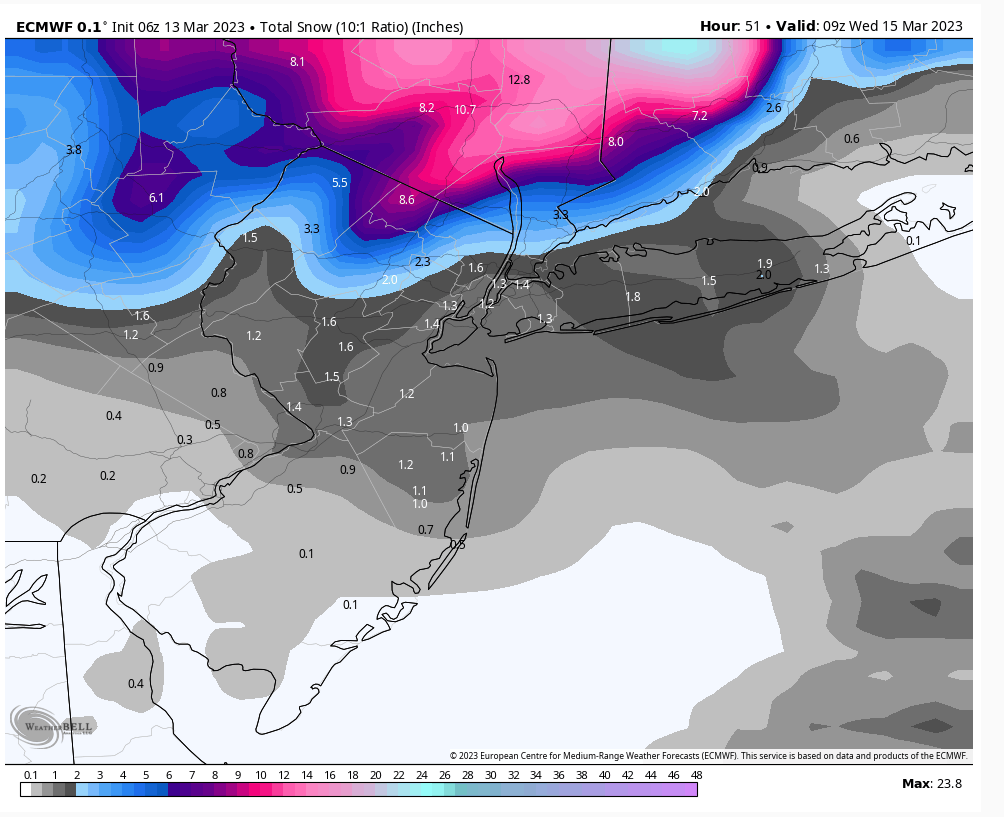
Here is this morning's EURO snow map

_________________
_______________________________________________________________________________________________________
CLICK HERE to view NJ Strong Snowstorm Classifications
 Re: March 13th-14th "Agita" Storm Part II
I don't think so. If there's an area that could see an upside it's E LI. The consolidation may happen in time for your hood. Especially if it deepens enough fast enough. No reason to think your area gets skunked ATTM. NYC/NE NJ highly doubt it too little too late IMO.sroc4 wrote:Uncle NAM is def hammered
heehaw453- Advanced Forecaster

- Posts : 3906
Reputation : 86
Join date : 2014-01-20
Location : Bedminster Township, PA Elevation 600' ASL
 Re: March 13th-14th "Agita" Storm Part II
_________________
_______________________________________________________________________________________________________
CLICK HERE to view NJ Strong Snowstorm Classifications
 Re: March 13th-14th "Agita" Storm Part II
_________________
-Alex Iannone-

aiannone- Senior Enthusiast - Mod

- Posts : 4815
Reputation : 92
Join date : 2013-01-07
Location : Saint James, LI (Northwest Suffolk Co.)
heehaw453- Advanced Forecaster

- Posts : 3906
Reputation : 86
Join date : 2014-01-20
Location : Bedminster Township, PA Elevation 600' ASL
 Re: March 13th-14th "Agita" Storm Part II
If yuo have not noticed the rusn have moved N since yesterday after a meso low erally casued havoc amongst them. This whole winter has been such where we go from good snows to really nada. Once the pattern for some reason gets locked in for garbage it doesnt change with some cattle prod to the atmosphere. I'll be lucky to see 2" out of this event after teh models at 500mb where showing such a great set up days ago. Amazing, Nature will do what she wants and when she wants as God only knows!!!
Went from a WSW of 4-7" here at work to 2-5". Oh well. March 2018 differences are stark - pure arctic air entrenched and reinfrocing HP over SE CAN. This is bootleg modified polar air not true arctic.
I'll track but with SROC for I shall be getting work done that I've unattended to for this. Loking fwd to Frank's updated map of lowering amounts in NNJ except for above 500' like West Milford, Sussex and Morris Counties would be my guess.
_________________
Mugs
AKA:King: Snow Weenie
Self Proclaimed
WINTER 2014-15 : 55.12" +.02 for 6 coatings (avg. 35")
WINTER 2015-16 Total - 29.8" (Avg 35")
WINTER 2016-17 : 39.5" so far

amugs- Advanced Forecaster - Mod

- Posts : 15095
Reputation : 213
Join date : 2013-01-07
Age : 54
Location : Hillsdale,NJ
RJB8525 and weatherwatchermom like this post
 Re: March 13th-14th "Agita" Storm Part II
Best look in days for my part of Bucks County--hope it happens!
kalleg- Posts : 148
Reputation : 2
Join date : 2013-01-15
Location : New Hope, PA
 Re: March 13th-14th "Agita" Storm Part II
12z GFS was close enough to be very interesting
_________________
-Alex Iannone-

aiannone- Senior Enthusiast - Mod

- Posts : 4815
Reputation : 92
Join date : 2013-01-07
Location : Saint James, LI (Northwest Suffolk Co.)
 Re: March 13th-14th "Agita" Storm Part II
heehaw453 wrote:I don't think so. If there's an area that could see an upside it's E LI. The consolidation may happen in time for your hood. Especially if it deepens enough fast enough. No reason to think your area gets skunked ATTM. NYC/NE NJ highly doubt it too little too late IMO.sroc4 wrote:Uncle NAM is def hammered
A little reverse psychology at work here Heehaw. I def recognize the potential come mid day through eve tomorrow for my neck of the woods. GFS, and NAM are hinting at it. It will prob be a now cast situation
_________________
"In weather and in life, there's no winning and losing; there's only winning and learning."
WINTER 2012/2013 TOTALS 43.65"WINTER 2017/2018 TOTALS 62.85" WINTER 2022/2023 TOTALS 4.9"
WINTER 2013/2014 TOTALS 64.85"WINTER 2018/2019 TOTALS 14.25" WINTER 2023/2024 TOTALS 13.1"
WINTER 2014/2015 TOTALS 71.20"WINTER 2019/2020 TOTALS 6.35"
WINTER 2015/2016 TOTALS 35.00"WINTER 2020/2021 TOTALS 37.75"
WINTER 2016/2017 TOTALS 42.25"WINTER 2021/2022 TOTALS 31.65"

sroc4- Admin

- Posts : 8354
Reputation : 302
Join date : 2013-01-07
Location : Wading River, LI
heehaw453, weatherwatchermom and billg315 like this post
 Re: March 13th-14th "Agita" Storm Part II
Anytime we see Miller B setups look to I90 corridor ALB-->Berkshires-->Worcester for jackpot. BOS only if it's cold enough which it's not. We see this time and time again.
heehaw453- Advanced Forecaster

- Posts : 3906
Reputation : 86
Join date : 2014-01-20
Location : Bedminster Township, PA Elevation 600' ASL
 Re: March 13th-14th "Agita" Storm Part II
@ Sroc-can we start to get a tad bit excited out in Manorville/Wading River?
dsix85- Pro Enthusiast

- Posts : 349
Reputation : 8
Join date : 2014-01-01
Location : New York
heehaw453- Advanced Forecaster

- Posts : 3906
Reputation : 86
Join date : 2014-01-20
Location : Bedminster Township, PA Elevation 600' ASL
 Re: March 13th-14th "Agita" Storm Part II
heehaw453 wrote:Anytime we see Miller B setups look to I90 corridor ALB-->Berkshires-->Worcester for jackpot. BOS only if it's cold enough which it's not. We see this time and time again.
lol I texted my girlfriend this morning the forcast map and the map of where her daughter is going to school in the fall(Worcester MA)...told her she better get her winter stuff during the current sales on LLBean and Landsend..(my own son could be anywhere from RhodeIsland to Boston next year...too soon for us..) I guess we are not going to get more than our coating we had all winter...

weatherwatchermom- Senior Enthusiast

- Posts : 3793
Reputation : 78
Join date : 2014-11-25
Location : Hazlet Township, NJ
 Re: March 13th-14th "Agita" Storm Part II
expecting exactly ongats from this nada here in edison
phil155- Pro Enthusiast

- Posts : 483
Reputation : 4
Join date : 2019-12-16
 Re: March 13th-14th "Agita" Storm Part II
heehaw453 wrote:Anytime we see Miller B setups look to I90 corridor ALB-->Berkshires-->Worcester for jackpot. BOS only if it's cold enough which it's not. We see this time and time again.
Ugh, Miller B's, never like them.
I thought this coming storm was going to be a Miller A, but apparently, I was off on that.The March 1993 was a Miller A coming right up the coast.Too bad for my location in Mahwah NJ, it mixed with sleet and there was 17 inches, 3 inches of which on top was sleet.Out by NE PA, they had 36 inches.

docstox12- Wx Statistician Guru

- Posts : 8530
Reputation : 222
Join date : 2013-01-07
Age : 73
Location : Monroe NY
 Re: March 13th-14th "Agita" Storm Part II
dsix85 wrote:@ Sroc-can we start to get a tad bit excited out in Manorville/Wading River?
I cant get excited yet. Its likely going to be a nowcast situation. Will have to watch how the low and meso low all behaves and see how the back end snow bands develop and where they develop as the system matures.
_________________
"In weather and in life, there's no winning and losing; there's only winning and learning."
WINTER 2012/2013 TOTALS 43.65"WINTER 2017/2018 TOTALS 62.85" WINTER 2022/2023 TOTALS 4.9"
WINTER 2013/2014 TOTALS 64.85"WINTER 2018/2019 TOTALS 14.25" WINTER 2023/2024 TOTALS 13.1"
WINTER 2014/2015 TOTALS 71.20"WINTER 2019/2020 TOTALS 6.35"
WINTER 2015/2016 TOTALS 35.00"WINTER 2020/2021 TOTALS 37.75"
WINTER 2016/2017 TOTALS 42.25"WINTER 2021/2022 TOTALS 31.65"

sroc4- Admin

- Posts : 8354
Reputation : 302
Join date : 2013-01-07
Location : Wading River, LI
 Re: March 13th-14th "Agita" Storm Part II
anytime people rely on backend snow and storms stalling they are usually disappointed
sroc4 wrote:dsix85 wrote:@ Sroc-can we start to get a tad bit excited out in Manorville/Wading River?
I cant get excited yet. Its likely going to be a nowcast situation. Will have to watch how the low and meso low all behaves and see how the back end snow bands develop and where they develop as the system matures.
Scullybutcher- Pro Enthusiast

- Posts : 543
Reputation : 16
Join date : 2013-02-06
Location : North Smithtown, western Suffolk county, long island
sroc4 likes this post
 Re: March 13th-14th "Agita" Storm Part II
Scullybutcher wrote:anytime people rely on backend snow and storms stalling they are usually disappointedsroc4 wrote:dsix85 wrote:@ Sroc-can we start to get a tad bit excited out in Manorville/Wading River?
That's my experience too. How far west will this back end snow potentially extend if it happens?
I cant get excited yet. Its likely going to be a nowcast situation. Will have to watch how the low and meso low all behaves and see how the back end snow bands develop and where they develop as the system matures.
lglickman1- Pro Enthusiast

- Posts : 319
Reputation : 0
Join date : 2013-02-05
Location : New Rochelle, NY
 Re: March 13th-14th "Agita" Storm Part II
Scullybutcher wrote:anytime people rely on backend snow and storms stalling they are usually disappointedsroc4 wrote:dsix85 wrote:@ Sroc-can we start to get a tad bit excited out in Manorville/Wading River?
I cant get excited yet. Its likely going to be a nowcast situation. Will have to watch how the low and meso low all behaves and see how the back end snow bands develop and where they develop as the system matures.
At least there is definite blocking Scully so there there will be a maturing CCB developing and the Low will stall nd even retrograde some. Its a matter of whether or not the southern energy is too far east or a tad closer to the coast to interact with the energy in the trough later vs sooner. If sooner like the Nam we are in the game in Suffolk county. If later...oogatz I wont hold my breath, but will watch closely.
_________________
"In weather and in life, there's no winning and losing; there's only winning and learning."
WINTER 2012/2013 TOTALS 43.65"WINTER 2017/2018 TOTALS 62.85" WINTER 2022/2023 TOTALS 4.9"
WINTER 2013/2014 TOTALS 64.85"WINTER 2018/2019 TOTALS 14.25" WINTER 2023/2024 TOTALS 13.1"
WINTER 2014/2015 TOTALS 71.20"WINTER 2019/2020 TOTALS 6.35"
WINTER 2015/2016 TOTALS 35.00"WINTER 2020/2021 TOTALS 37.75"
WINTER 2016/2017 TOTALS 42.25"WINTER 2021/2022 TOTALS 31.65"

sroc4- Admin

- Posts : 8354
Reputation : 302
Join date : 2013-01-07
Location : Wading River, LI
Scullybutcher likes this post
Page 5 of 15 •  1, 2, 3, 4, 5, 6 ... 10 ... 15
Page 5 of 15
Permissions in this forum:
You cannot reply to topics in this forum|
|
|

 Home
Home