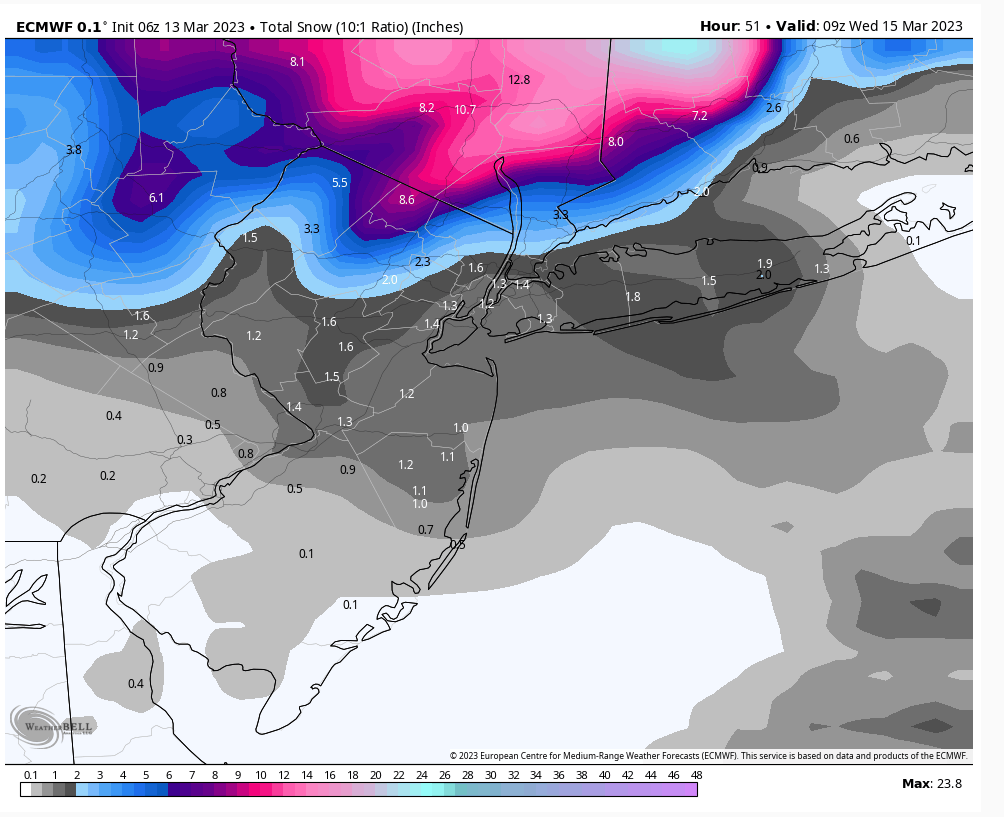
March 13th-14th "Agita" Storm Part II
+37
Artingerb
Vinnydula
essexcountypete
DAYBLAZER
brownie
crippo84
2004blackwrx
tomsriversnowstorm
billg315
Scullybutcher
dsix85
aiannone
SENJsnowman
kalleg
sroc4
Radz
phil155
docstox12
1190ftalt
SNOW MAN
TheAresian
hyde345
Dunnzoo
MattyICE
dkodgis
CPcantmeasuresnow
lglickman1
frank 638
rb924119
nutleyblizzard
Coachgriff
amugs
CNWestMilford
weatherwatchermom
jmanley32
heehaw453
Frank_Wx
41 posters
Page 4 of 15
Page 4 of 15 •  1, 2, 3, 4, 5 ... 9 ... 15
 Re: March 13th-14th "Agita" Storm Part II
SNOW MAN wrote:rb924119 wrote:For what little it may be worth, I’m trying to analyze from my phone - I just got to my parents’ place in the Poconos lol I work 11am-9:30pm, in case you were wondering why so late aha
To the point, I’m telling you, DO NOT SLEEP ON THIS IF YOU ARE BETWEEN I-84 and I-78. The more I look at this, the more I see March 2, 2018. Everything is on the EXACT same trajectory. The models are trying to errantly leap frog the main energy to the eastern energy. In my opinion, this is wrong. It’s kind of like putting the cart before the proverbial horse. This storm is developing too-down, not bottom-up. H5 is maturing first, then H7, H850, and finally the surface. This is clearly evident on all models. With that being the case, it makes no sense that all of a sudden the coastal surface low, which is developing IN RESPONSE TO the maturing mid- and low-level cyclones maturing above it FIRST, would start controlling the show. Yes, it will rapidly deepen, but AFTER the cyclones are doing so above it. This evolution has a huge impact on the distribution of precipitation. If you are anywhere north of the H5 trough axis, youre in good shape. Right now, I still stand by what I said earlier. But I am trying to do some further analysis.
rb I think your going to be correct. The NWS has put my area in a WSW for 12-18 inches of snow with higher amounts possible in the higher elevations. I'm in Marshalls Creek PA. just below where your parents live.
Snow Man, good to see ya, brother!! Thanks for the support! I have a 50-50 shot haha
As I continue analyze this, here’s what I’m thinking:
1. We see a sharper height field out ahead of our approaching mid-level cyclone as a result of increased latent heat release from the relatively “warmer” ocean coupled with offshore convection.
2. A slightly southward displacement of the cyclonic evolution based on hemispheric and tropical forcing mechanisms. It won’t be by much, maybe 25-50 miles, but I do think it happens.
As a result of these two in things, I think we will see an overall more robust/earlier/more efficient consolidation of energies and maturation versus what is being currently modeled. Therefore, an enhancement of the forcing mechanisms in play the same ones I mentioned earlier yesterday) should be realized at game time, with a further southwestward displacement of snowfall.
rb924119- Meteorologist

- Posts : 6928
Join date : 2013-02-06
 Re: March 13th-14th "Agita" Storm Part II
36 degrees, cloudy, drizzle calm winds.Upgraded to warning here , anywhere between 4 to 12 inches, higher amounts 500 to 750 feet.I am over 500 feet.Nowcast time, any wobbles can make a difference either way .
7:01 Just checked, elevation of Monroe NY 636 feet.
7:01 Just checked, elevation of Monroe NY 636 feet.
Last edited by docstox12 on Mon Mar 13, 2023 7:01 am; edited 1 time in total
docstox12- Wx Statistician Guru

- Posts : 8530
Join date : 2013-01-07
 Re: March 13th-14th "Agita" Storm Part II
Well, going to bed last night, most of us were hanging onto the NAM(s) - but even that left us. Now all we have is luck and RB! See if we can go down swinging this winter!
MattyICE- Advanced Forecaster

- Posts : 249
Reputation : 6
Join date : 2017-11-10
Age : 38
Location : Clifton, NJ (Eastern Passaic County)
phil155 likes this post
 Re: March 13th-14th "Agita" Storm Part II
Luck and rb are better than the models in my opinion. How many times have the models let us down after building us up a few days before an event
phil155- Pro Enthusiast

- Posts : 483
Reputation : 4
Join date : 2019-12-16
 Re: March 13th-14th "Agita" Storm Part II
37* light rain, looking at latest guidance, I don’t think I’ll see more than a slushy 1-2” at most here in the valley of northern most Westchester, see how things develop today, would love an upside surprise…
Radz- Pro Enthusiast

- Posts : 1028
Reputation : 17
Join date : 2013-01-12
Location : Cortlandt Manor NY
 Re: March 13th-14th "Agita" Storm Part II
I see the coast lost nam support if we get a earlier maturation as he said is our only hope but pretty sure the ciast is toast except for flooding rains and some gusty winds.

jmanley32- Senior Enthusiast

- Posts : 20535
Reputation : 108
Join date : 2013-12-12
Age : 43
Location : Yonkers, NY
 Re: March 13th-14th "Agita" Storm Part II
last i checked you guts had watch for 4 to 7. Ill be lucky to see a ciating to 2.Radz wrote:37* light rain, looking at latest guidance, I don’t think I’ll see more than a slushy 1-2” at most here in the valley of northern most Westchester, see how things develop today, would love an upside surprise…
Oh did not see you were downgraded to a advisory, yeah this is all goingto be well north and the highest will be catskills and berkshires and MA. They will also see high wind warning criteria, lucky them they go have hell of a storm.
heehaw if I were you I would go to central eastern mass but I know you all don't like mass but its go be wild there.

jmanley32- Senior Enthusiast

- Posts : 20535
Reputation : 108
Join date : 2013-12-12
Age : 43
Location : Yonkers, NY
 Re: March 13th-14th "Agita" Storm Part II
The board has come alive. How nice.
It looks like my totals per NWS are modest-5-8 inches and the action has shifted east but then again, I want to believe I will be snowbombed so the only convincing now I need is to get that snow on the ground and improve my measuring techniques gracias a CP
It looks like my totals per NWS are modest-5-8 inches and the action has shifted east but then again, I want to believe I will be snowbombed so the only convincing now I need is to get that snow on the ground and improve my measuring techniques gracias a CP

dkodgis- Senior Enthusiast

- Posts : 2560
Reputation : 98
Join date : 2013-12-29
 Re: March 13th-14th "Agita" Storm Part II
I don't think this is going to work out for NYC/EPA and possibly NEPA. My thoughts are this ULL closes off too fast thereby brining it too far north. This close off is telling me the energy doesn't consolidate with the offshore energy until its too late. It will catch up but it'll be for Berskshires in Western MA. NW NJ/LHV you'll get yours just don't think it's widespread Godzilla amounts.


heehaw453- Advanced Forecaster

- Posts : 3906
Reputation : 86
Join date : 2014-01-20
Location : Bedminster Township, PA Elevation 600' ASL
 Re: March 13th-14th "Agita" Storm Part II
Damian see my post as to why.dkodgis wrote:The board has come alive. How nice.
It looks like my totals per NWS are modest-5-8 inches and the action has shifted east but then again, I want to believe I will be snowbombed so the only convincing now I need is to get that snow on the ground and improve my measuring techniques gracias a CP
heehaw453- Advanced Forecaster

- Posts : 3906
Reputation : 86
Join date : 2014-01-20
Location : Bedminster Township, PA Elevation 600' ASL
 Re: March 13th-14th "Agita" Storm Part II
NAM lost the meso low last night. We now have model consensus, though I can see why Ray feels they are lost. We’ll just have to wait and see.
Central NY and southern NE are going to get slammed with some pretty wet snow. Could be a dangerous situation in some parts. I’ll have an updated snow map this afternoon.
Central NY and southern NE are going to get slammed with some pretty wet snow. Could be a dangerous situation in some parts. I’ll have an updated snow map this afternoon.
_________________
_______________________________________________________________________________________________________
CLICK HERE to view NJ Strong Snowstorm Classifications
 Re: March 13th-14th "Agita" Storm Part II
Yeah. I won't be surprised if Central Park records nothing from this and they are .6" away from epic futility, but IMO that's already been achieved. Had the temps been cold then definitely several inches were on the table with or w/out the dynamics.jmanley32 wrote:Headed to work just a normal rainy day in Yonkers, looks like my year end is 4.5 inches, beating out the previous lowest. At this point I have accepted it and am moving on. And it does look like you are right heehaw most has shifted to bershires and further east. Bummer even for those in upper NY.heehaw453 wrote:I don't think this is going to work out for NYC/EPA and possibly NEPA. My thoughts are this ULL closes off too fast thereby brining it too far north. This close off is telling me the energy doesn't consolidate with the offshore energy until its too late. It will catch up but it'll be for Berskshires in Western MA. NW NJ/LHV you'll get yours just don't think it's widespread Godzilla amounts.
heehaw453- Advanced Forecaster

- Posts : 3906
Reputation : 86
Join date : 2014-01-20
Location : Bedminster Township, PA Elevation 600' ASL
 Re: March 13th-14th "Agita" Storm Part II
I think most of your snow comes before midnight tonight. I'll be shocked if Poconos areas picks up anywhere close to 1'.SNOW MAN wrote:rb924119 wrote:For what little it may be worth, I’m trying to analyze from my phone - I just got to my parents’ place in the Poconos lol I work 11am-9:30pm, in case you were wondering why so late aha
To the point, I’m telling you, DO NOT SLEEP ON THIS IF YOU ARE BETWEEN I-84 and I-78. The more I look at this, the more I see March 2, 2018. Everything is on the EXACT same trajectory. The models are trying to errantly leap frog the main energy to the eastern energy. In my opinion, this is wrong. It’s kind of like putting the cart before the proverbial horse. This storm is developing too-down, not bottom-up. H5 is maturing first, then H7, H850, and finally the surface. This is clearly evident on all models. With that being the case, it makes no sense that all of a sudden the coastal surface low, which is developing IN RESPONSE TO the maturing mid- and low-level cyclones maturing above it FIRST, would start controlling the show. Yes, it will rapidly deepen, but AFTER the cyclones are doing so above it. This evolution has a huge impact on the distribution of precipitation. If you are anywhere north of the H5 trough axis, youre in good shape. Right now, I still stand by what I said earlier. But I am trying to do some further analysis.
rb I think your going to be correct. The NWS has put my area in a WSW for 12-18 inches of snow with higher amounts possible in the higher elevations. I'm in Marshalls Creek PA. just below where your parents live.
edit: outside of > 1500' ASL
Last edited by heehaw453 on Mon Mar 13, 2023 7:55 am; edited 1 time in total
heehaw453- Advanced Forecaster

- Posts : 3906
Reputation : 86
Join date : 2014-01-20
Location : Bedminster Township, PA Elevation 600' ASL
 Re: March 13th-14th "Agita" Storm Part II
jmanley32 wrote:last i checked you guts had watch for 4 to 7. Ill be lucky to see a ciating to 2.Radz wrote:37* light rain, looking at latest guidance, I don’t think I’ll see more than a slushy 1-2” at most here in the valley of northern most Westchester, see how things develop today, would love an upside surprise…
Oh did not see you were downgraded to a advisory, yeah this is all goingto be well north and the highest will be catskills and berkshires and MA. They will also see high wind warning criteria, lucky them they go have hell of a storm.
heehaw if I were you I would go to central eastern mass but I know you all don't like mass but its go be wild there.
Yup, and I’m right in that downslope area that usually under performs while the “hills” west of me will accumulate some snow lol

Radz- Pro Enthusiast

- Posts : 1028
Reputation : 17
Join date : 2013-01-12
Location : Cortlandt Manor NY
 Re: March 13th-14th "Agita" Storm Part II
heehaw453 wrote:I think most of your snow comes before midnight tonight. I'll be shocked if Poconos areas picks up anywhere close to 1'.SNOW MAN wrote:rb924119 wrote:For what little it may be worth, I’m trying to analyze from my phone - I just got to my parents’ place in the Poconos lol I work 11am-9:30pm, in case you were wondering why so late aha
To the point, I’m telling you, DO NOT SLEEP ON THIS IF YOU ARE BETWEEN I-84 and I-78. The more I look at this, the more I see March 2, 2018. Everything is on the EXACT same trajectory. The models are trying to errantly leap frog the main energy to the eastern energy. In my opinion, this is wrong. It’s kind of like putting the cart before the proverbial horse. This storm is developing too-down, not bottom-up. H5 is maturing first, then H7, H850, and finally the surface. This is clearly evident on all models. With that being the case, it makes no sense that all of a sudden the coastal surface low, which is developing IN RESPONSE TO the maturing mid- and low-level cyclones maturing above it FIRST, would start controlling the show. Yes, it will rapidly deepen, but AFTER the cyclones are doing so above it. This evolution has a huge impact on the distribution of precipitation. If you are anywhere north of the H5 trough axis, youre in good shape. Right now, I still stand by what I said earlier. But I am trying to do some further analysis.
rb I think your going to be correct. The NWS has put my area in a WSW for 12-18 inches of snow with higher amounts possible in the higher elevations. I'm in Marshalls Creek PA. just below where your parents live.
Challenge accepted
rb924119- Meteorologist

- Posts : 6928
Reputation : 194
Join date : 2013-02-06
Age : 32
Location : Greentown, Pa
heehaw453 likes this post
 Re: March 13th-14th "Agita" Storm Part II
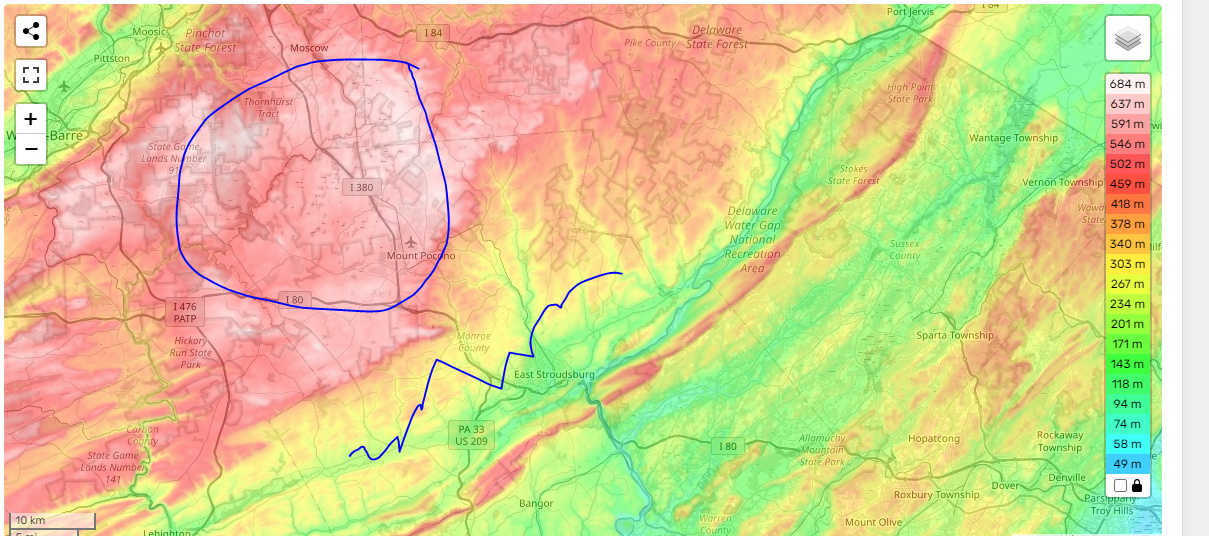
Let's do this Rb! I think that those accumulations in Poconos would be for > 1500' ASL. A lot of that area is < 1000' especially around Stroudsburg. I could see Tobyhanna area getting a 1' and that's where I was for March 2, 2018. It was beautiful watching snow rip off the lake. You think the lower elevated areas in NEPA get a 1'?rb924119 wrote:heehaw453 wrote:I think most of your snow comes before midnight tonight. I'll be shocked if Poconos areas picks up anywhere close to 1'.SNOW MAN wrote:rb924119 wrote:For what little it may be worth, I’m trying to analyze from my phone - I just got to my parents’ place in the Poconos lol I work 11am-9:30pm, in case you were wondering why so late aha
To the point, I’m telling you, DO NOT SLEEP ON THIS IF YOU ARE BETWEEN I-84 and I-78. The more I look at this, the more I see March 2, 2018. Everything is on the EXACT same trajectory. The models are trying to errantly leap frog the main energy to the eastern energy. In my opinion, this is wrong. It’s kind of like putting the cart before the proverbial horse. This storm is developing too-down, not bottom-up. H5 is maturing first, then H7, H850, and finally the surface. This is clearly evident on all models. With that being the case, it makes no sense that all of a sudden the coastal surface low, which is developing IN RESPONSE TO the maturing mid- and low-level cyclones maturing above it FIRST, would start controlling the show. Yes, it will rapidly deepen, but AFTER the cyclones are doing so above it. This evolution has a huge impact on the distribution of precipitation. If you are anywhere north of the H5 trough axis, youre in good shape. Right now, I still stand by what I said earlier. But I am trying to do some further analysis.
rb I think your going to be correct. The NWS has put my area in a WSW for 12-18 inches of snow with higher amounts possible in the higher elevations. I'm in Marshalls Creek PA. just below where your parents live.
Challenge acceptedhahaha
edit: This area here maybe a 1'. Outside of that I don't think so.
heehaw453- Advanced Forecaster

- Posts : 3906
Reputation : 86
Join date : 2014-01-20
Location : Bedminster Township, PA Elevation 600' ASL
rb924119 likes this post
 Re: March 13th-14th "Agita" Storm Part II
Morning. I've been quiet mostly because since my area has gone to she-ITE, Ive lost some interest and figure id watch a row back with the headset on and the clipboard. Bernie with regards to the NAM yesterday I think said it best. Uncle NAM has def been sipping on the Bourbons, but maybe just maybe there is some brilliance amidst the slurring. LOL  Back to the head set and clip board.
 Back to the head set and clip board.
 _________________
"In weather and in life, there's no winning and losing; there's only winning and learning."
WINTER 2012/2013 TOTALS 43.65"WINTER 2017/2018 TOTALS 62.85" WINTER 2022/2023 TOTALS 4.9"
WINTER 2013/2014 TOTALS 64.85"WINTER 2018/2019 TOTALS 14.25" WINTER 2023/2024 TOTALS 13.1"
WINTER 2014/2015 TOTALS 71.20"WINTER 2019/2020 TOTALS 6.35"
WINTER 2015/2016 TOTALS 35.00"WINTER 2020/2021 TOTALS 37.75"
WINTER 2016/2017 TOTALS 42.25"WINTER 2021/2022 TOTALS 31.65"

sroc4- Admin

- Posts : 8354
Reputation : 302
Join date : 2013-01-07
Location : Wading River, LI
rb924119 and heehaw453 like this post
 Re: March 13th-14th "Agita" Storm Part II
I think anywhere near and above 1000 feet would have a chance at double-digit snowfall here in NEPA. I’m currently at about 1750’ where I am, and Tobyhanna sits right around 1900’, on average. So, for sake of argument, let’s call Stroudsburg a push, heehaw, since they’re borderline.
For reference, I think anywhere in the Glaciated Low Plateau and Pocono Plateau sections of this map are solidly in the running for double digits.
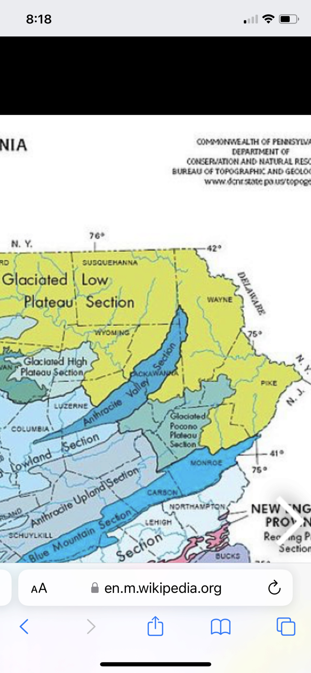
For reference, I think anywhere in the Glaciated Low Plateau and Pocono Plateau sections of this map are solidly in the running for double digits.

rb924119- Meteorologist

- Posts : 6928
Reputation : 194
Join date : 2013-02-06
Age : 32
Location : Greentown, Pa
kalleg and heehaw453 like this post
 Re: March 13th-14th "Agita" Storm Part II
sroc4 wrote:Morning. I've been quiet mostly because since my area has gone to she-ITE, Ive lost some interest and figure id watch a row back with the headset on and the clipboard. Bernie with regards to the NAM yesterday I think said it best. Uncle NAM has def been sipping on the Bourbons, but maybe just maybe there is some brilliance amidst the slurring. LOLBack to the head set and clip board.
I’ve been wondering where you’ve been!
I guess I’m in good company with the NAM, then, minus the bourbon lol
rb924119- Meteorologist

- Posts : 6928
Reputation : 194
Join date : 2013-02-06
Age : 32
Location : Greentown, Pa
sroc4 likes this post
 Re: March 13th-14th "Agita" Storm Part II
>= 1000' ASL --> 1' and >= 1500' --> 15" would be my call. I'm not going to be surprised for the areas under say 700' be in the 6-8" range in NEPA.rb924119 wrote:I think anywhere near and above 1000 feet would have a chance at double-digit snowfall here in NEPA. I’m currently at about 1750’ where I am, and Tobyhanna sits right around 1900’, on average. So, for sake of argument, let’s call Stroudsburg a push, heehaw, since they’re borderline.
For reference, I think anywhere in the Glaciated Low Plateau and Pocono Plateau sections of this map are solidly in the running for double digits.
heehaw453- Advanced Forecaster

- Posts : 3906
Reputation : 86
Join date : 2014-01-20
Location : Bedminster Township, PA Elevation 600' ASL
rb924119 likes this post
 Re: March 13th-14th "Agita" Storm Part II
Saw a highway sign all trailors and tandems banned from berkshires today thrpugh wed. Gonna have some delivery delays up there. Also ive never seen that.

jmanley32- Senior Enthusiast

- Posts : 20535
Reputation : 108
Join date : 2013-12-12
Age : 43
Location : Yonkers, NY
 Re: March 13th-14th "Agita" Storm Part II
37* light rain in New Hope.
NWS: Today Rain. High near 44. East wind 5 to 10 mph. Chance of precipitation is 90%. New precipitation amounts between a quarter and half of an inch possible.
Tonight Rain. Low around 33. Northwest wind 5 to 15 mph. Chance of precipitation is 100%. New precipitation amounts between three quarters and one inch possible.
If only all that rain could be snow....sigh....
Last edited by kalleg on Mon Mar 13, 2023 8:47 am; edited 1 time in total (Reason for editing : added comment)
kalleg- Posts : 148
Reputation : 2
Join date : 2013-01-15
Location : New Hope, PA
 Re: March 13th-14th "Agita" Storm Part II
heehaw453 wrote:>= 1000' ASL --> 1' and >= 1500' --> 15" would be my call. I'm not going to be surprised for the areas under say 700' be in the 6-8" range in NEPA.rb924119 wrote:I think anywhere near and above 1000 feet would have a chance at double-digit snowfall here in NEPA. I’m currently at about 1750’ where I am, and Tobyhanna sits right around 1900’, on average. So, for sake of argument, let’s call Stroudsburg a push, heehaw, since they’re borderline.
For reference, I think anywhere in the Glaciated Low Plateau and Pocono Plateau sections of this map are solidly in the running for double digits.
Then we aren’t really any different from each other after all haha it’s a moot point lol sure, we could nitpick over a couple inches, but I think we are largely on the same page.
rb924119- Meteorologist

- Posts : 6928
Reputation : 194
Join date : 2013-02-06
Age : 32
Location : Greentown, Pa
heehaw453 likes this post
heehaw453- Advanced Forecaster

- Posts : 3906
Reputation : 86
Join date : 2014-01-20
Location : Bedminster Township, PA Elevation 600' ASL

docstox12- Wx Statistician Guru

- Posts : 8530
Reputation : 222
Join date : 2013-01-07
Age : 73
Location : Monroe NY
CPcantmeasuresnow likes this post
 Re: March 13th-14th "Agita" Storm Part II
The atmospheric streamflow is already beginning to reorient itself, as can be seen by the development of parallel banding features and their subsequent motion on radar.
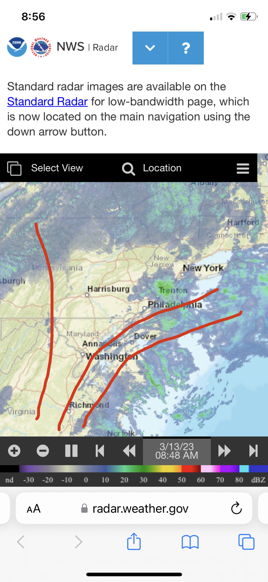
This is why the precip field is filling on radar - you’re beginning to see the atmosphere “spread apart” in response to the forcing mechanisms in play creating forcing for ascent. Strictly anecdotally, whenever I’ve seen precipitation falling well in advance of a storm, it’s always boded well. At least in my recent working memory, which admittedly, is not all that long haha

This is why the precip field is filling on radar - you’re beginning to see the atmosphere “spread apart” in response to the forcing mechanisms in play creating forcing for ascent. Strictly anecdotally, whenever I’ve seen precipitation falling well in advance of a storm, it’s always boded well. At least in my recent working memory, which admittedly, is not all that long haha
rb924119- Meteorologist

- Posts : 6928
Reputation : 194
Join date : 2013-02-06
Age : 32
Location : Greentown, Pa
heehaw453 likes this post
SENJsnowman- Senior Enthusiast

- Posts : 1189
Reputation : 61
Join date : 2017-01-06
Age : 51
Location : Bayville, NJ
docstox12 and CPcantmeasuresnow like this post
Page 4 of 15 •  1, 2, 3, 4, 5 ... 9 ... 15
Page 4 of 15
Permissions in this forum:
You cannot reply to topics in this forum|
|
|

 Home
Home