
 Search
September Obs & Discussions
Page 8 of 15 •  1 ... 5 ... 7, 8, 9 ... 11 ... 15
 ![]()
Re: September Obs & Discussions
![]() by rb924119 Fri Sep 22, 2023 8:58 am
by rb924119 Fri Sep 22, 2023 8:58 am
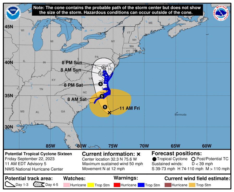
sroc4 wrote:rb924119 wrote:Approximate location of where I think the center of circulation is superimposed on the NHC track to represent where it should be:
I followed up with my approximate track, and so far, they align well, in my opinion, if you use geographical landmarks for reference.
Not sure about the lat but looks like you have Long east of 75W. Current visible sat suggests enter of LLC is west of 75W by my eye
https://www.tropicaltidbits.com/sat/satlooper.php?region=goes16-meso2&product=vis


I’m looking at infrared imagery, Scott. The reason being is that it’s been my contention that models have been too far west with where the mid-level circulations would coalesce and organize, which has implications on the overall steering. Now that we are seeing the convection organize pretty rapidly, it should also start inducing pressure falls along with it and start working to coalesce the low-level circulation with the mid-levels.


The locations are outlined in green, for reference.
rb924119- Meteorologist

- Posts : 6890
Join date : 2013-02-06
Re: September Obs & Discussions
![]() by jmanley32 Fri Sep 22, 2023 9:45 am
by jmanley32 Fri Sep 22, 2023 9:45 am
So basically it is going to completely change its location? Then why does the NHC not know or show this? Not to knock your idea but aren't they supposed to be the be all end all expects (lol, they change a million times kinda kidding). I have heard of systems developing a new COC when forming thats why often tracks change once they have developed. You could be onto somrthing will be interesting if this actually happens, will def be a game changer.rb924119 wrote:sroc4 wrote:rb924119 wrote:Approximate location of where I think the center of circulation is superimposed on the NHC track to represent where it should be:
I followed up with my approximate track, and so far, they align well, in my opinion, if you use geographical landmarks for reference.
Not sure about the lat but looks like you have Long east of 75W. Current visible sat suggests enter of LLC is west of 75W by my eye
https://www.tropicaltidbits.com/sat/satlooper.php?region=goes16-meso2&product=vis
I’m looking at infrared imagery, Scott. The reason being is that it’s been my contention that models have been too far west with where the mid-level circulations would coalesce and organize, which has implications on the overall steering. Now that we are seeing the convection organize pretty rapidly, it should also start inducing pressure falls along with it and start working to coalesce the low-level circulation with the mid-levels.
The locations are outlined in green, for reference.
jmanley32- Senior Enthusiast

- Posts : 20517
Join date : 2013-12-12
Re: September Obs & Discussions
![]() by sroc4 Fri Sep 22, 2023 10:16 am
by sroc4 Fri Sep 22, 2023 10:16 am
jmanley32 wrote:So basically it is going to completely change its location? Then why does the NHC not know or show this? Not to knock your idea but aren't they supposed to be the be all end all expects (lol, they change a million times kinda kidding). I have heard of systems developing a new COC when forming thats why often tracks change once they have developed. You could be onto somrthing will be interesting if this actually happens, will def be a game changer.rb924119 wrote:sroc4 wrote:rb924119 wrote:Approximate location of where I think the center of circulation is superimposed on the NHC track to represent where it should be:
I followed up with my approximate track, and so far, they align well, in my opinion, if you use geographical landmarks for reference.
Not sure about the lat but looks like you have Long east of 75W. Current visible sat suggests enter of LLC is west of 75W by my eye
https://www.tropicaltidbits.com/sat/satlooper.php?region=goes16-meso2&product=vis
I’m looking at infrared imagery, Scott. The reason being is that it’s been my contention that models have been too far west with where the mid-level circulations would coalesce and organize, which has implications on the overall steering. Now that we are seeing the convection organize pretty rapidly, it should also start inducing pressure falls along with it and start working to coalesce the low-level circulation with the mid-levels.
The locations are outlined in green, for reference.
IMHO, and I am by no means no expert, but what Ive stated before is shaping up. The LLC (low level center) is where I outlined above and is tracking towards thge NC coast as predicted; however, keep im mind I had pointed out that as this thing gained lat there were two seperate waves. The initial wave of PVA will track N into the area over night tonight and early tomorrow providing the first wave of precip, followed by a "lull"; then a second round of precip associated with the main LP as it gets to our Lat and turns ENE.
IMO this is what we are seeing this am. The IR sat shows what appears to be two mid level circulations that seem to consolidate east. First around 32.5N 75.75W; the second near 75.25W and 33N. Byy the end of the loop they appear to consolidate into one further East.
FWIW it appears the LLC is broad and exposed with the main convection setting up N and NNW of it. Likely the rersult of the N shear that you can see on WV imagery.
https://www.tropicaltidbits.com/sat/satlooper.php?region=16L&product=ir
https://www.tropicaltidbits.com/sat/satlooper.php?region=16L&product=vis
https://www.tropicaltidbits.com/sat/satlooper.php?region=16L&product=wv_mid
_________________
"In weather and in life, there's no winning and losing; there's only winning and learning."
WINTER 2012/2013 TOTALS 43.65"WINTER 2017/2018 TOTALS 62.85" WINTER 2022/2023 TOTALS 4.9"
WINTER 2013/2014 TOTALS 64.85"WINTER 2018/2019 TOTALS 14.25" WINTER 2023/2024 TOTALS 13.1"
WINTER 2014/2015 TOTALS 71.20"WINTER 2019/2020 TOTALS 6.35"
WINTER 2015/2016 TOTALS 35.00"WINTER 2020/2021 TOTALS 37.75"
WINTER 2016/2017 TOTALS 42.25"WINTER 2021/2022 TOTALS 31.65"

sroc4- Admin

- Posts : 8331
Reputation : 301
Join date : 2013-01-07
Location : Wading River, LI
rb924119 likes this post
Re: September Obs & Discussions
![]() by rb924119 Fri Sep 22, 2023 10:16 am
by rb924119 Fri Sep 22, 2023 10:16 am
rb924119- Meteorologist
- Posts : 6890
Reputation : 194
Join date : 2013-02-06
Age : 32
Location : Greentown, Pa
jmanley32 likes this post
Re: September Obs & Discussions
![]() by amugs Fri Sep 22, 2023 10:20 am
by amugs Fri Sep 22, 2023 10:20 am

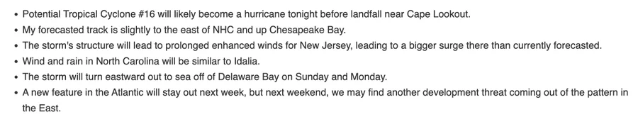
From JB
_________________
Mugs
AKA:King: Snow Weenie
Self Proclaimed
WINTER 2014-15 : 55.12" +.02 for 6 coatings (avg. 35")
WINTER 2015-16 Total - 29.8" (Avg 35")
WINTER 2016-17 : 39.5" so far

amugs- Advanced Forecaster - Mod

- Posts : 15093
Reputation : 213
Join date : 2013-01-07
Age : 54
Location : Hillsdale,NJ
rb924119 likes this post
Re: September Obs & Discussions
![]() by jmanley32 Fri Sep 22, 2023 10:22 am
by jmanley32 Fri Sep 22, 2023 10:22 am
are you reading jb twitter lol, just said same, and has somilar thoughts to yours. I agree completely, since it is already a 50mph storm, and is progged to reach strong TS and possibly hurrican strength before landfalling somewhere from NC to delmarva. And why are they not naming it Ophelia, makes no sense, they name storms that pose 0 threat to land like Nigil but this one will and gets no name, how insulting to the storm lolrb924119 wrote:We’ll see what happens, but right now I have no changes. Also, why are there no recon flights for this thing? They can’t say that it’s because it won’t be tropical because they do it for winter storms…….IDK.

jmanley32- Senior Enthusiast
- Posts : 20517
Reputation : 108
Join date : 2013-12-12
Age : 42
Location : Yonkers, NY
Re: September Obs & Discussions
![]() by docstox12 Fri Sep 22, 2023 10:29 am
by docstox12 Fri Sep 22, 2023 10:29 am
Right now partly cloudy, calm and 60 degrees.

docstox12- Wx Statistician Guru

- Posts : 8507
Reputation : 222
Join date : 2013-01-07
Age : 73
Location : Monroe NY
Re: September Obs & Discussions
![]() by sroc4 Fri Sep 22, 2023 10:38 am
by sroc4 Fri Sep 22, 2023 10:38 am
jmanley32 wrote:are you reading jb twitter lol, just said same, and has somilar thoughts to yours. I agree completely, since it is already a 50mph storm, and is progged to reach strong TS and possibly hurrican strength before landfalling somewhere from NC to delmarva. And why are they not naming it Ophelia, makes no sense, they name storms that pose 0 threat to land like Nigil but this one will and gets no name, how insulting to the storm lolrb924119 wrote:We’ll see what happens, but right now I have no changes. Also, why are there no recon flights for this thing? They can’t say that it’s because it won’t be tropical because they do it for winter storms…….IDK.
If Im a betting man since its not currently "warm core" they aren't naming it as a truly tropical storm despite trop storm winds. Question is does it have enough time to go warm core before landfall. Again likely a technicality, but likely the reasoning. They at least are categorizing it as a trop storm and putting up the appropriate warnings but a true name...thats different.
_________________
"In weather and in life, there's no winning and losing; there's only winning and learning."
WINTER 2012/2013 TOTALS 43.65"WINTER 2017/2018 TOTALS 62.85" WINTER 2022/2023 TOTALS 4.9"
WINTER 2013/2014 TOTALS 64.85"WINTER 2018/2019 TOTALS 14.25" WINTER 2023/2024 TOTALS 13.1"
WINTER 2014/2015 TOTALS 71.20"WINTER 2019/2020 TOTALS 6.35"
WINTER 2015/2016 TOTALS 35.00"WINTER 2020/2021 TOTALS 37.75"
WINTER 2016/2017 TOTALS 42.25"WINTER 2021/2022 TOTALS 31.65"
sroc4- Admin
- Posts : 8331
Reputation : 301
Join date : 2013-01-07
Location : Wading River, LI
rb924119 likes this post
Re: September Obs & Discussions
![]() by jmanley32 Fri Sep 22, 2023 10:39 am
by jmanley32 Fri Sep 22, 2023 10:39 am
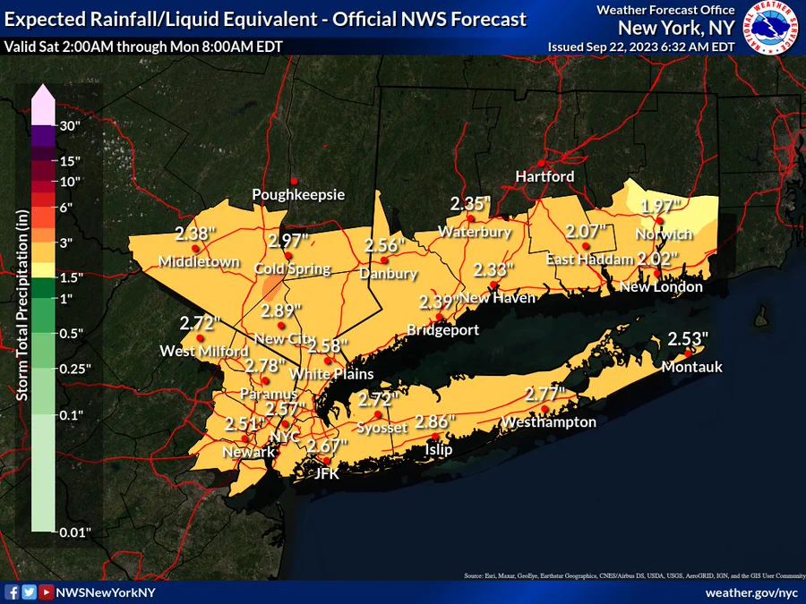
pretty much entire area, you should escape most of windy conditions, nowhere has dry ground though.docstox12 wrote:Wow, almost 3 inches in the LHV.Will be a mess for sure up here.
Right now partly cloudy, calm and 60 degrees.
jmanley32- Senior Enthusiast
- Posts : 20517
Reputation : 108
Join date : 2013-12-12
Age : 42
Location : Yonkers, NY
docstox12 likes this post
Re: September Obs & Discussions
![]() by amugs Fri Sep 22, 2023 10:48 am
by amugs Fri Sep 22, 2023 10:48 am
_________________
Mugs
AKA:King: Snow Weenie
Self Proclaimed
WINTER 2014-15 : 55.12" +.02 for 6 coatings (avg. 35")
WINTER 2015-16 Total - 29.8" (Avg 35")
WINTER 2016-17 : 39.5" so far
amugs- Advanced Forecaster - Mod
- Posts : 15093
Reputation : 213
Join date : 2013-01-07
Age : 54
Location : Hillsdale,NJ
docstox12 and rb924119 like this post
Re: September Obs & Discussions
![]() by docstox12 Fri Sep 22, 2023 10:58 am
by docstox12 Fri Sep 22, 2023 10:58 am
jmanley32 wrote:pretty much entire area, you should escape most of windy conditions, nowhere has dry ground though.docstox12 wrote:Wow, almost 3 inches in the LHV.Will be a mess for sure up here.
Right now partly cloudy, calm and 60 degrees.
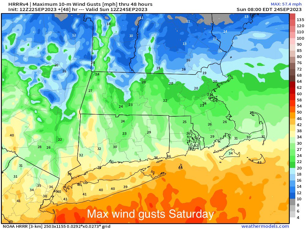
Glad the winds here will not be that high, don't want trees coming down.Your area looks like almost 40MPH.
docstox12- Wx Statistician Guru
- Posts : 8507
Reputation : 222
Join date : 2013-01-07
Age : 73
Location : Monroe NY
Re: September Obs & Discussions
![]() by amugs Fri Sep 22, 2023 11:06 am
by amugs Fri Sep 22, 2023 11:06 am
Winds
_________________
Mugs
AKA:King: Snow Weenie
Self Proclaimed
WINTER 2014-15 : 55.12" +.02 for 6 coatings (avg. 35")
WINTER 2015-16 Total - 29.8" (Avg 35")
WINTER 2016-17 : 39.5" so far
amugs- Advanced Forecaster - Mod
- Posts : 15093
Reputation : 213
Join date : 2013-01-07
Age : 54
Location : Hillsdale,NJ
Re: September Obs & Discussions
![]() by sroc4 Fri Sep 22, 2023 11:08 am
by sroc4 Fri Sep 22, 2023 11:08 am

https://www.tropicaltidbits.com/sat/satlooper.php?region=16L&product=wv_mid
_________________
"In weather and in life, there's no winning and losing; there's only winning and learning."
WINTER 2012/2013 TOTALS 43.65"WINTER 2017/2018 TOTALS 62.85" WINTER 2022/2023 TOTALS 4.9"
WINTER 2013/2014 TOTALS 64.85"WINTER 2018/2019 TOTALS 14.25" WINTER 2023/2024 TOTALS 13.1"
WINTER 2014/2015 TOTALS 71.20"WINTER 2019/2020 TOTALS 6.35"
WINTER 2015/2016 TOTALS 35.00"WINTER 2020/2021 TOTALS 37.75"
WINTER 2016/2017 TOTALS 42.25"WINTER 2021/2022 TOTALS 31.65"
sroc4- Admin
- Posts : 8331
Reputation : 301
Join date : 2013-01-07
Location : Wading River, LI
rb924119 likes this post
Re: September Obs & Discussions
![]() by amugs Fri Sep 22, 2023 11:11 am
by amugs Fri Sep 22, 2023 11:11 am

_________________
Mugs
AKA:King: Snow Weenie
Self Proclaimed
WINTER 2014-15 : 55.12" +.02 for 6 coatings (avg. 35")
WINTER 2015-16 Total - 29.8" (Avg 35")
WINTER 2016-17 : 39.5" so far
amugs- Advanced Forecaster - Mod
- Posts : 15093
Reputation : 213
Join date : 2013-01-07
Age : 54
Location : Hillsdale,NJ
Re: September Obs & Discussions
![]() by jmanley32 Fri Sep 22, 2023 11:43 am
by jmanley32 Fri Sep 22, 2023 11:43 am
Ya from what mugs posted, 35-45, but i dunno if thats from the storm itself cuz NHC has us basically not attaining any winds over 39mph, atm anyways.docstox12 wrote:jmanley32 wrote:pretty much entire area, you should escape most of windy conditions, nowhere has dry ground though.docstox12 wrote:Wow, almost 3 inches in the LHV.Will be a mess for sure up here.
Right now partly cloudy, calm and 60 degrees.
Glad the winds here will not be that high, don't want trees coming down.Your area looks like almost 40MPH.
jmanley32- Senior Enthusiast
- Posts : 20517
Reputation : 108
Join date : 2013-12-12
Age : 42
Location : Yonkers, NY
Re: September Obs & Discussions
![]() by rb924119 Fri Sep 22, 2023 12:24 pm
by rb924119 Fri Sep 22, 2023 12:24 pm
amugs wrote:Friend at shore - Brick said winds are picking up, tying up boat and adding more bumpers/fenders to dock. Neighbors asked what he was doing and he said we have storm coming.....they have no idea as do many others.
Can confirm, mugsy, already gusting to 30 here on LBI.
rb924119- Meteorologist
- Posts : 6890
Reputation : 194
Join date : 2013-02-06
Age : 32
Location : Greentown, Pa
Re: September Obs & Discussions
![]() by rb924119 Fri Sep 22, 2023 12:26 pm
by rb924119 Fri Sep 22, 2023 12:26 pm
jmanley32 wrote:are you reading jb twitter lol, just said same, and has somilar thoughts to yours. I agree completely, since it is already a 50mph storm, and is progged to reach strong TS and possibly hurrican strength before landfalling somewhere from NC to delmarva. And why are they not naming it Ophelia, makes no sense, they name storms that pose 0 threat to land like Nigil but this one will and gets no name, how insulting to the storm lolrb924119 wrote:We’ll see what happens, but right now I have no changes. Also, why are there no recon flights for this thing? They can’t say that it’s because it won’t be tropical because they do it for winter storms…….IDK.
Nope, I stay away from social media - I have better things to do aha but at least I know I’m not alone haha
Don’t we have an Ode to Ophelia….? Lol maybe should recite it as an offering so we can be spared the worst haha
rb924119- Meteorologist
- Posts : 6890
Reputation : 194
Join date : 2013-02-06
Age : 32
Location : Greentown, Pa
sroc4, docstox12 and kalleg like this post
Re: September Obs & Discussions
![]() by rb924119 Fri Sep 22, 2023 12:28 pm
by rb924119 Fri Sep 22, 2023 12:28 pm
sroc4 wrote:jmanley32 wrote:So basically it is going to completely change its location? Then why does the NHC not know or show this? Not to knock your idea but aren't they supposed to be the be all end all expects (lol, they change a million times kinda kidding). I have heard of systems developing a new COC when forming thats why often tracks change once they have developed. You could be onto somrthing will be interesting if this actually happens, will def be a game changer.rb924119 wrote:sroc4 wrote:rb924119 wrote:Approximate location of where I think the center of circulation is superimposed on the NHC track to represent where it should be:
I followed up with my approximate track, and so far, they align well, in my opinion, if you use geographical landmarks for reference.
Not sure about the lat but looks like you have Long east of 75W. Current visible sat suggests enter of LLC is west of 75W by my eye
https://www.tropicaltidbits.com/sat/satlooper.php?region=goes16-meso2&product=vis
I’m looking at infrared imagery, Scott. The reason being is that it’s been my contention that models have been too far west with where the mid-level circulations would coalesce and organize, which has implications on the overall steering. Now that we are seeing the convection organize pretty rapidly, it should also start inducing pressure falls along with it and start working to coalesce the low-level circulation with the mid-levels.
The locations are outlined in green, for reference.
IMHO, and I am by no means no expert, but what Ive stated before is shaping up. The LLC (low level center) is where I outlined above and is tracking towards thge NC coast as predicted; however, keep im mind I had pointed out that as this thing gained lat there were two seperate waves. The initial wave of PVA will track N into the area over night tonight and early tomorrow providing the first wave of precip, followed by a "lull"; then a second round of precip associated with the main LP as it gets to our Lat and turns ENE.
IMO this is what we are seeing this am. The IR sat shows what appears to be two mid level circulations that seem to consolidate east. First around 32.5N 75.75W; the second near 75.25W and 33N. Byy the end of the loop they appear to consolidate into one further East.
FWIW it appears the LLC is broad and exposed with the main convection setting up N and NNW of it. Likely the rersult of the N shear that you can see on WV imagery.
https://www.tropicaltidbits.com/sat/satlooper.php?region=16L&product=ir
https://www.tropicaltidbits.com/sat/satlooper.php?region=16L&product=vis
https://www.tropicaltidbits.com/sat/satlooper.php?region=16L&product=wv_mid
It seems like we are in relative agreement, Scott, just taking two different angles at it
rb924119- Meteorologist
- Posts : 6890
Reputation : 194
Join date : 2013-02-06
Age : 32
Location : Greentown, Pa
Re: September Obs & Discussions
![]() by jmanley32 Fri Sep 22, 2023 12:34 pm
by jmanley32 Fri Sep 22, 2023 12:34 pm
probably a smart thing. So placement looks to be west of your thoughts by my somewhat untrained eye, does it still go due north though instead of that sharp curve is the question, NHC says no dice. The windfield is already well inland, its huge however so thats not surprising, do we still think this will become a weak cat 1? There are some breezes picking up here too.rb924119 wrote:jmanley32 wrote:are you reading jb twitter lol, just said same, and has somilar thoughts to yours. I agree completely, since it is already a 50mph storm, and is progged to reach strong TS and possibly hurrican strength before landfalling somewhere from NC to delmarva. And why are they not naming it Ophelia, makes no sense, they name storms that pose 0 threat to land like Nigil but this one will and gets no name, how insulting to the storm lolrb924119 wrote:We’ll see what happens, but right now I have no changes. Also, why are there no recon flights for this thing? They can’t say that it’s because it won’t be tropical because they do it for winter storms…….IDK.
Nope, I stay away from social media - I have better things to do aha but at least I know I’m not alone haha
Don’t we have an Ode to Ophelia….? Lol maybe should recite it as an offering so we can be spared the worst haha
jmanley32- Senior Enthusiast
- Posts : 20517
Reputation : 108
Join date : 2013-12-12
Age : 42
Location : Yonkers, NY
Re: September Obs & Discussions
![]() by jmanley32 Fri Sep 22, 2023 12:57 pm
by jmanley32 Fri Sep 22, 2023 12:57 pm
jmanley32- Senior Enthusiast
- Posts : 20517
Reputation : 108
Join date : 2013-12-12
Age : 42
Location : Yonkers, NY
rb924119 likes this post
Re: September Obs & Discussions
![]() by amugs Fri Sep 22, 2023 1:00 pm
by amugs Fri Sep 22, 2023 1:00 pm
_________________
Mugs
AKA:King: Snow Weenie
Self Proclaimed
WINTER 2014-15 : 55.12" +.02 for 6 coatings (avg. 35")
WINTER 2015-16 Total - 29.8" (Avg 35")
WINTER 2016-17 : 39.5" so far
amugs- Advanced Forecaster - Mod
- Posts : 15093
Reputation : 213
Join date : 2013-01-07
Age : 54
Location : Hillsdale,NJ
Re: September Obs & Discussions
![]() by rb924119 Fri Sep 22, 2023 1:04 pm
by rb924119 Fri Sep 22, 2023 1:04 pm
jmanley32 wrote:probably a smart thing. So placement looks to be west of your thoughts by my somewhat untrained eye, does it still go due north though instead of that sharp curve is the question, NHC says no dice. The windfield is already well inland, its huge however so thats not surprising, do we still think this will become a weak cat 1? There are some breezes picking up here too.rb924119 wrote:jmanley32 wrote:are you reading jb twitter lol, just said same, and has somilar thoughts to yours. I agree completely, since it is already a 50mph storm, and is progged to reach strong TS and possibly hurrican strength before landfalling somewhere from NC to delmarva. And why are they not naming it Ophelia, makes no sense, they name storms that pose 0 threat to land like Nigil but this one will and gets no name, how insulting to the storm lolrb924119 wrote:We’ll see what happens, but right now I have no changes. Also, why are there no recon flights for this thing? They can’t say that it’s because it won’t be tropical because they do it for winter storms…….IDK.
Nope, I stay away from social media - I have better things to do aha but at least I know I’m not alone haha
Don’t we have an Ode to Ophelia….? Lol maybe should recite it as an offering so we can be spared the worst haha
I think it can get to that intensity, yes.
rb924119- Meteorologist
- Posts : 6890
Reputation : 194
Join date : 2013-02-06
Age : 32
Location : Greentown, Pa
Re: September Obs & Discussions
![]() by jmanley32 Fri Sep 22, 2023 1:05 pm
by jmanley32 Fri Sep 22, 2023 1:05 pm
https://www.tropicaltidbits.com/sat/satlooper.php?region=16L&product=vis
jmanley32- Senior Enthusiast
- Posts : 20517
Reputation : 108
Join date : 2013-12-12
Age : 42
Location : Yonkers, NY
Re: September Obs & Discussions
![]() by rb924119 Fri Sep 22, 2023 1:06 pm
by rb924119 Fri Sep 22, 2023 1:06 pm
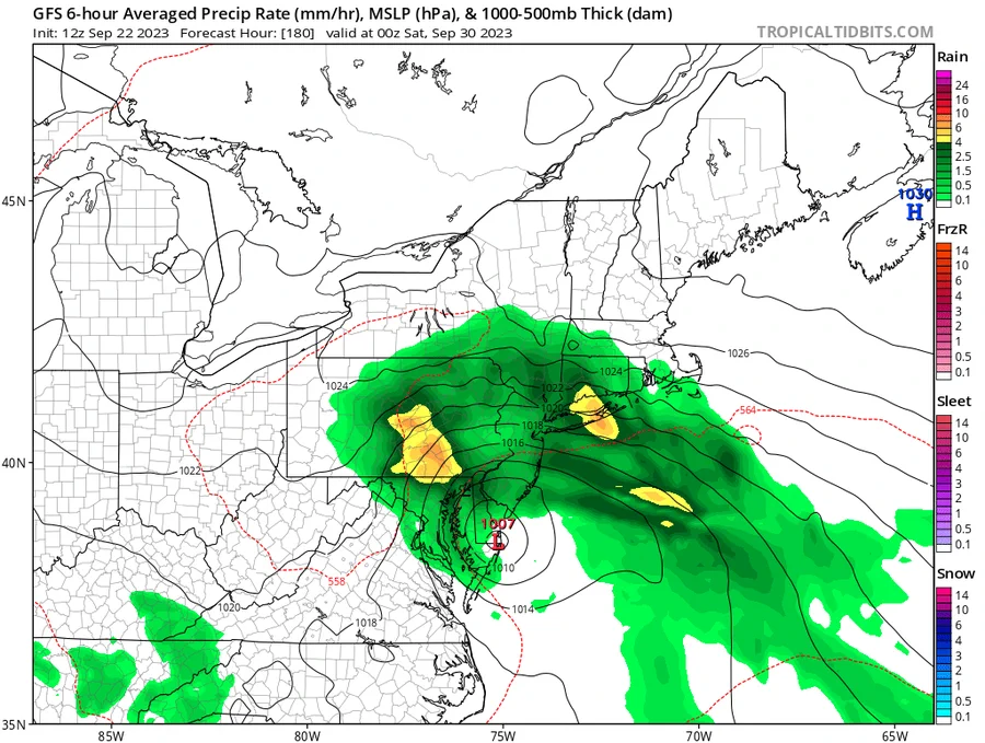
jmanley32 wrote:12z CMC is on board the GFS in giving half as much rain 1.5-2 inches and taking that sharp left and going well inland. Rb not sure if your ideas can still hold without the CMC, unless we need to start watching the SR models. Not saying you couldn't still be right but model guidance appears against it.
I don’t agree with that left hook, but we’ll see. I agree with you on all accounts here, though.
rb924119- Meteorologist
- Posts : 6890
Reputation : 194
Join date : 2013-02-06
Age : 32
Location : Greentown, Pa
Re: September Obs & Discussions
![]() by rb924119 Fri Sep 22, 2023 1:07 pm
by rb924119 Fri Sep 22, 2023 1:07 pm
amugs wrote:Who wants to do this all again next weekend???? pattern recognition says so peeps!!
I was waiting to get through this one before talking about the next one, but yes, we may very well do this again aha
rb924119- Meteorologist
- Posts : 6890
Reputation : 194
Join date : 2013-02-06
Age : 32
Location : Greentown, Pa
Re: September Obs & Discussions
![]() by jmanley32 Fri Sep 22, 2023 1:07 pm
by jmanley32 Fri Sep 22, 2023 1:07 pm
Well as long as it stays north track the better looks for you. What is supposed to draw it westward?rb924119 wrote:jmanley32 wrote:12z CMC is on board the GFS in giving half as much rain 1.5-2 inches and taking that sharp left and going well inland. Rb not sure if your ideas can still hold without the CMC, unless we need to start watching the SR models. Not saying you couldn't still be right but model guidance appears against it.
I don’t agree with that left hook, but we’ll see. I agree with you on all accounts here, though.
jmanley32- Senior Enthusiast
- Posts : 20517
Reputation : 108
Join date : 2013-12-12
Age : 42
Location : Yonkers, NY
Re: September Obs & Discussions
![]() by amugs Fri Sep 22, 2023 1:24 pm
by amugs Fri Sep 22, 2023 1:24 pm
rb924119 wrote:amugs wrote:Who wants to do this all again next weekend???? pattern recognition says so peeps!!
I was waiting to get through this one before talking about the next one, but yes, we may very well do this again aha
Rb I hear ya but you know - i multiwxtask - whats on deck as "we" collectively take this one on LOL!!
It is this storm that actually loops back SW and regenerates into another hybrid Noreaster next weekend..... if ONLY in winter it be WOWZA!!
This is like an olympic 3 round fight, ding ding!!
@IsaacWxObserver @SteveOweathaguy @USAwx this weekend storm loops SW and the reintensifies. Imagine if winter?!! I saw you post about this earlier upon review it seems as it is just this? pic.twitter.com/rDVgDFr2Mt
— Al Mugno (@MugnoaAl) September 22, 2023
_________________
Mugs
AKA:King: Snow Weenie
Self Proclaimed
WINTER 2014-15 : 55.12" +.02 for 6 coatings (avg. 35")
WINTER 2015-16 Total - 29.8" (Avg 35")
WINTER 2016-17 : 39.5" so far
amugs- Advanced Forecaster - Mod
- Posts : 15093
Reputation : 213
Join date : 2013-01-07
Age : 54
Location : Hillsdale,NJ
Page 8 of 15 • 1 ... 5 ... 7, 8, 9 ... 11 ... 15 ![]()
|
|
|