
 Search
September Obs & Discussions
Page 5 of 15 •  1, 2, 3, 4, 5, 6 ... 10 ... 15
 ![]()
Re: September Obs & Discussions
![]() by amugs Wed Sep 20, 2023 1:24 pm
by amugs Wed Sep 20, 2023 1:24 pm
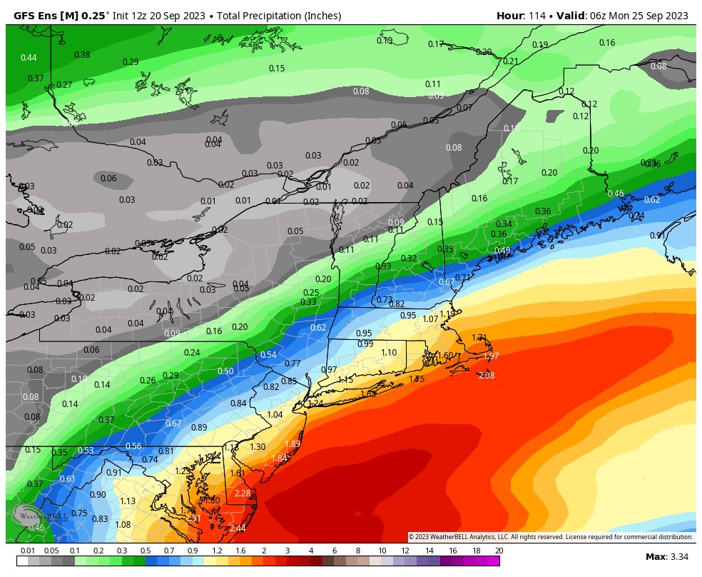
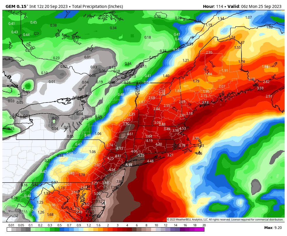
Canadian model is a major flooding rainstorm
amugs- Advanced Forecaster - Mod

- Posts : 15095
Join date : 2013-01-07
Re: September Obs & Discussions
![]() by jmanley32 Wed Sep 20, 2023 2:13 pm
by jmanley32 Wed Sep 20, 2023 2:13 pm
I imagine the CMC gusts may be higher being it has more intense rains and a bit stronger of a system.

jmanley32- Senior Enthusiast

- Posts : 20535
Join date : 2013-12-12
Re: September Obs & Discussions
![]() by sroc4 Wed Sep 20, 2023 2:23 pm
by sroc4 Wed Sep 20, 2023 2:23 pm
_________________
"In weather and in life, there's no winning and losing; there's only winning and learning."
WINTER 2012/2013 TOTALS 43.65"WINTER 2017/2018 TOTALS 62.85" WINTER 2022/2023 TOTALS 4.9"
WINTER 2013/2014 TOTALS 64.85"WINTER 2018/2019 TOTALS 14.25" WINTER 2023/2024 TOTALS 13.1"
WINTER 2014/2015 TOTALS 71.20"WINTER 2019/2020 TOTALS 6.35"
WINTER 2015/2016 TOTALS 35.00"WINTER 2020/2021 TOTALS 37.75"
WINTER 2016/2017 TOTALS 42.25"WINTER 2021/2022 TOTALS 31.65"

sroc4- Admin

- Posts : 8354
Reputation : 302
Join date : 2013-01-07
Location : Wading River, LI
Re: September Obs & Discussions
![]() by jmanley32 Wed Sep 20, 2023 2:29 pm
by jmanley32 Wed Sep 20, 2023 2:29 pm
sroc4 wrote:Euro keeps flip flopping on how far north it wants to bring the precip shield. Back to mostly a miss
Well we got 2 against one and as mugs pointed out the Euro is not what it used to be. But we shall see. We do not even have a system yet which is kinda nuts cuz we are within 72 hrs or less.

jmanley32- Senior Enthusiast
- Posts : 20535
Reputation : 108
Join date : 2013-12-12
Age : 43
Location : Yonkers, NY
Re: September Obs & Discussions
![]() by aiannone Wed Sep 20, 2023 2:31 pm
by aiannone Wed Sep 20, 2023 2:31 pm
_________________
-Alex Iannone-

aiannone- Senior Enthusiast - Mod
- Posts : 4815
Reputation : 92
Join date : 2013-01-07
Location : Saint James, LI (Northwest Suffolk Co.)
weatherwatchermom likes this post
Re: September Obs & Discussions
![]() by jmanley32 Wed Sep 20, 2023 2:31 pm
by jmanley32 Wed Sep 20, 2023 2:31 pm
sroc4 wrote:Euro keeps flip flopping on how far north it wants to bring the precip shield. Back to mostly a miss
May I also say that is the craziest perfectly curved razor sharp cut off i've ever seen. you know if it was winter we would be tearing out hair out lol
jmanley32- Senior Enthusiast
- Posts : 20535
Reputation : 108
Join date : 2013-12-12
Age : 43
Location : Yonkers, NY
weatherwatchermom likes this post
Re: September Obs & Discussions
![]() by rb924119 Wed Sep 20, 2023 3:03 pm
by rb924119 Wed Sep 20, 2023 3:03 pm
sroc4 wrote:Euro keeps flip flopping on how far north it wants to bring the precip shield. Back to mostly a miss
I think the EURO is having some major issues here. It keeps wanting to shear the associated trough and split it, leaving a piece behind. First, this is a known bias, as you know. Secondly, I don’t think it fits the pattern. I think the whole thing is going to have to be ejected northeastward from the little bit I have actually looked at this. I think a 40/30/30 blend of the ICON, GFS, and GEM might be the best idea here, but that’s HIGHLY preliminary, and I’ll have much more details to come later.
rb924119- Meteorologist

- Posts : 6928
Reputation : 194
Join date : 2013-02-06
Age : 32
Location : Greentown, Pa
docstox12, kalleg, jmanley32, weatherwatchermom and MattyICE like this post
Re: September Obs & Discussions
![]() by sroc4 Wed Sep 20, 2023 6:28 pm
by sroc4 Wed Sep 20, 2023 6:28 pm
rb924119 wrote:sroc4 wrote:Euro keeps flip flopping on how far north it wants to bring the precip shield. Back to mostly a miss
I think the EURO is having some major issues here. It keeps wanting to shear the associated trough and split it, leaving a piece behind. First, this is a known bias, as you know. Secondly, I don’t think it fits the pattern. I think the whole thing is going to have to be ejected northeastward from the little bit I have actually looked at this. I think a 40/30/30 blend of the ICON, GFS, and GEM might be the best idea here, but that’s HIGHLY preliminary, and I’ll have much more details to come later.
The mean Total precip on the 12z eps was def much wetter, but I am not ready to say this isn’t plausible. Granted it’s 18z but GFs is going towards the similar soln. There appears to be a trough to the north that descents southward creating confluence that appears to be shearing the initial 500vorticuty kicking it east, while the main vort and associated LP gets pulled back towards the coast initially. Then when it gets picked up in the mean flow the confluence shears it out as well. Timing and how far south this confluence sets up I think plays a major role here.
_________________
"In weather and in life, there's no winning and losing; there's only winning and learning."
WINTER 2012/2013 TOTALS 43.65"WINTER 2017/2018 TOTALS 62.85" WINTER 2022/2023 TOTALS 4.9"
WINTER 2013/2014 TOTALS 64.85"WINTER 2018/2019 TOTALS 14.25" WINTER 2023/2024 TOTALS 13.1"
WINTER 2014/2015 TOTALS 71.20"WINTER 2019/2020 TOTALS 6.35"
WINTER 2015/2016 TOTALS 35.00"WINTER 2020/2021 TOTALS 37.75"
WINTER 2016/2017 TOTALS 42.25"WINTER 2021/2022 TOTALS 31.65"
sroc4- Admin
- Posts : 8354
Reputation : 302
Join date : 2013-01-07
Location : Wading River, LI
Re: September Obs & Discussions
![]() by sroc4 Wed Sep 20, 2023 6:32 pm
by sroc4 Wed Sep 20, 2023 6:32 pm
First sw digs followed by the second wave. These are both from 18z gfs.


_________________
"In weather and in life, there's no winning and losing; there's only winning and learning."
WINTER 2012/2013 TOTALS 43.65"WINTER 2017/2018 TOTALS 62.85" WINTER 2022/2023 TOTALS 4.9"
WINTER 2013/2014 TOTALS 64.85"WINTER 2018/2019 TOTALS 14.25" WINTER 2023/2024 TOTALS 13.1"
WINTER 2014/2015 TOTALS 71.20"WINTER 2019/2020 TOTALS 6.35"
WINTER 2015/2016 TOTALS 35.00"WINTER 2020/2021 TOTALS 37.75"
WINTER 2016/2017 TOTALS 42.25"WINTER 2021/2022 TOTALS 31.65"
sroc4- Admin
- Posts : 8354
Reputation : 302
Join date : 2013-01-07
Location : Wading River, LI
Re: September Obs & Discussions
![]() by billg315 Wed Sep 20, 2023 7:57 pm
by billg315 Wed Sep 20, 2023 7:57 pm

billg315- Advanced Forecaster - Mod
- Posts : 4483
Reputation : 185
Join date : 2015-01-24
Age : 50
Location : Flemington, NJ
sroc4 and kalleg like this post
Re: September Obs & Discussions
![]() by rb924119 Thu Sep 21, 2023 3:04 am
by rb924119 Thu Sep 21, 2023 3:04 am
Although the situation could be worse, I think this storm is going to be problematic, with a track that would have it NOT landfall in North Carolina, and come north into a zone that ranges from the Delmarva to NYC. I think it will rapidly achieve category 1 hurricane status (or equivalent if not named), and possibly remain so upon reaching our latitude, especially IF it avoids interaction with land. However, I’d put the odds of higher intensity at slightly less than those for strong tropical status (or equivalent). Roughly 55/45 split. Heavy rain and onshore wind will cause significant coastal flooding, especially at times of high tide, so I’d take precautions if you’re anywhere from Cape Cod southward, with the worst being the north shore of Long Island, New Jersey and southward. Impacts begin Friday night and last through midday Sunday, with Saturday being the worst of it.
This is a very tricky forecast. Firstly, I continue to believe that the EURO is struggling with this. The GFS/GEM/ICON blend is the best way to go, in my opinion, although I think the track ends up slightly further east (25-75 miles, give or take). Based on my analysis, the pattern seems to support the following ideas:
1. The trough associated with our storm should tend to lift out more cohesively and intact, as opposed to being a strung out mess like the EURO has been suggesting.
2. The incoming Canadian trough should end up being quicker and deeper than it has been modeled to.
3. We should see increased ridging develop to the west of the trough associated with our storm versus what has been modeled so far, which will help to keep the trough associated with our storm separate from the trough cutting through the Midwest, thereby preventing a sharp northwest hook like earlier runs were suggesting.
Additionally, this is a feedback storm from the bottom, up, which means that it’s not the mid- and upper-levels that develop the storm at the surface. In this case, we are getting the surface cyclone to develop first, feed back, and then the mid- and upper-levels respond. As a result of this, plus the factors outlined above, I think the modeling is a little too far west with the circulation. On top of that, the idea of rapid feedback would also support an initially slower northward movement, which would give the incoming Canadian trough more time to dig and press southeastward, and impart a little more west-east vector on the trough/storm. All of these factors are why I think it ends up avoiding landfall in North Carolina. However, I think a nearly due north track is a good bet. I also do not buy a total stall like the GFS has been trying to hint at. I think it may slow down a bit, but I think once it reaches the latitude of about Sandy Hook it should start to veer to the northeast.
Regarding the intensity, I think this rapidly intensifies into a category 1 (or equivalent if unnamed) due to enhanced convergence at the surface aided by strong high pressure to the north, northeast and east (eastern pressures further enhanced by the cooler water upwelled by Franklin and Lee relative to the warmer water near the U.S. coast), warm water, and a favorable environment for baroclinic processes (non-tropical processes) to aid with general forcing for ascent. If it encounters land, then it will weaken by the time it gets to our latitude, although still be a tropical storm intensity (or equivalent). If it doesn’t, which I don’t think it will, then I think it will certainly be a strong tropical storm (or equivalent), or even a low-end category 1 hurricane (or equivalent), as the combination of tropical and non-tropical processes should allow it to maintain intensity longer than it otherwise would if it was purely tropical (weaken slower).
I hope that was clear enough, folks. Sorry I can’t be more detailed, but it’s late, I need sleep, and I’ve done this entirely on my cell phone haha I’ll be checking in, though, so we can track this together. If you have any questions, you know the drill!
rb924119- Meteorologist
- Posts : 6928
Reputation : 194
Join date : 2013-02-06
Age : 32
Location : Greentown, Pa
kalleg, Grselig, dolphins222 and phil155 like this post
Re: September Obs & Discussions
![]() by jmanley32 Thu Sep 21, 2023 6:50 am
by jmanley32 Thu Sep 21, 2023 6:50 am
was not expecting what you suggest thats for sure. But all last nights models were stronger and the euro now on board with other two. If i missed it i apologize but when does this start to wrap up? I mean its go have be super quivk to reach that cat 1 sratus as we have roughly about 48 hrs or less to do so? This is also in line with bastardis ideas. The feedback thing i dont completely understand but both u have this idea. Great analysis and very easy to understand for the most part.rb924119 wrote:Ok, as promised, I’ve taken some time to formulate my thoughts. I’ll try to make this make sense as succinctly as possible.
Although the situation could be worse, I think this storm is going to be problematic, with a track that would have it NOT landfall in North Carolina, and come north into a zone that ranges from the Delmarva to NYC. I think it will rapidly achieve category 1 hurricane status (or equivalent if not named), and possibly remain so upon reaching our latitude, especially IF it avoids interaction with land. However, I’d put the odds of higher intensity at slightly less than those for strong tropical status (or equivalent). Roughly 55/45 split. Heavy rain and onshore wind will cause significant coastal flooding, especially at times of high tide, so I’d take precautions if you’re anywhere from Cape Cod southward, with the worst being the north shore of Long Island, New Jersey and southward. Impacts begin Friday night and last through midday Sunday, with Saturday being the worst of it.
This is a very tricky forecast. Firstly, I continue to believe that the EURO is struggling with this. The GFS/GEM/ICON blend is the best way to go, in my opinion, although I think the track ends up slightly further east (25-75 miles, give or take). Based on my analysis, the pattern seems to support the following ideas:
1. The trough associated with our storm should tend to lift out more cohesively and intact, as opposed to being a strung out mess like the EURO has been suggesting.
2. The incoming Canadian trough should end up being quicker and deeper than it has been modeled to.
3. We should see increased ridging develop to the west of the trough associated with our storm versus what has been modeled so far, which will help to keep the trough associated with our storm separate from the trough cutting through the Midwest, thereby preventing a sharp northwest hook like earlier runs were suggesting.
Additionally, this is a feedback storm from the bottom, up, which means that it’s not the mid- and upper-levels that develop the storm at the surface. In this case, we are getting the surface cyclone to develop first, feed back, and then the mid- and upper-levels respond. As a result of this, plus the factors outlined above, I think the modeling is a little too far west with the circulation. On top of that, the idea of rapid feedback would also support an initially slower northward movement, which would give the incoming Canadian trough more time to dig and press southeastward, and impart a little more west-east vector on the trough/storm. All of these factors are why I think it ends up avoiding landfall in North Carolina. However, I think a nearly due north track is a good bet. I also do not buy a total stall like the GFS has been trying to hint at. I think it may slow down a bit, but I think once it reaches the latitude of about Sandy Hook it should start to veer to the northeast.
Regarding the intensity, I think this rapidly intensifies into a category 1 (or equivalent if unnamed) due to enhanced convergence at the surface aided by strong high pressure to the north, northeast and east (eastern pressures further enhanced by the cooler water upwelled by Franklin and Lee relative to the warmer water near the U.S. coast), warm water, and a favorable environment for baroclinic processes (non-tropical processes) to aid with general forcing for ascent. If it encounters land, then it will weaken by the time it gets to our latitude, although still be a tropical storm intensity (or equivalent). If it doesn’t, which I don’t think it will, then I think it will certainly be a strong tropical storm (or equivalent), or even a low-end category 1 hurricane (or equivalent), as the combination of tropical and non-tropical processes should allow it to maintain intensity longer than it otherwise would if it was purely tropical (weaken slower).
I hope that was clear enough, folks. Sorry I can’t be more detailed, but it’s late, I need sleep, and I’ve done this entirely on my cell phone haha I’ll be checking in, though, so we can track this together. If you have any questions, you know the drill!
jmanley32- Senior Enthusiast
- Posts : 20535
Reputation : 108
Join date : 2013-12-12
Age : 43
Location : Yonkers, NY
Re: September Obs & Discussions
![]() by Grselig Thu Sep 21, 2023 7:21 am
by Grselig Thu Sep 21, 2023 7:21 am

Grselig- Senior Enthusiast
- Posts : 1408
Reputation : 140
Join date : 2013-03-04
Age : 54
Location : Wayne NJ
rb924119 likes this post
Re: September Obs & Discussions
![]() by amugs Thu Sep 21, 2023 9:55 am
by amugs Thu Sep 21, 2023 9:55 am
_________________
Mugs
AKA:King: Snow Weenie
Self Proclaimed
WINTER 2014-15 : 55.12" +.02 for 6 coatings (avg. 35")
WINTER 2015-16 Total - 29.8" (Avg 35")
WINTER 2016-17 : 39.5" so far

amugs- Advanced Forecaster - Mod
- Posts : 15095
Reputation : 213
Join date : 2013-01-07
Age : 54
Location : Hillsdale,NJ
rb924119 likes this post
Re: September Obs & Discussions
![]() by rb924119 Thu Sep 21, 2023 10:04 am
by rb924119 Thu Sep 21, 2023 10:04 am
rb924119- Meteorologist
- Posts : 6928
Reputation : 194
Join date : 2013-02-06
Age : 32
Location : Greentown, Pa
Re: September Obs & Discussions
![]() by rb924119 Thu Sep 21, 2023 10:05 am
by rb924119 Thu Sep 21, 2023 10:05 am
amugs wrote:EURO is a shell of what is once was - GGEM,CMC aka CanadianModel has been steadfast on this storm and was on Lee.
Agree 100%, mugsy.
rb924119- Meteorologist
- Posts : 6928
Reputation : 194
Join date : 2013-02-06
Age : 32
Location : Greentown, Pa
Re: September Obs & Discussions
![]() by jmanley32 Thu Sep 21, 2023 10:12 am
by jmanley32 Thu Sep 21, 2023 10:12 am
My bad I meant when does it start up, meaning gain formation and intensity (looks to be quick NHC says by tomorrow morning, I guess its in some pretty moderate to primo area for some development), if the brunt is less than 48 hrs away. NHC seems to be slowly coming around to some of your thoughts which is awesome for your track record, lets see how it goes. NHC just updated and stated watch's/warnings may go up as early as later this morning. Likely only Carolinas/maybe to delmarva for now, but if your analysis is right could be hurricane watches at some pt, I think, non-tropical or not, despite most on here hating this they issue them anyways as that changed ever since Sandy. Seems all bets are off for any outdoor activities for Sat so am kinda hoping for some excitement from this storm but nothing terrible, as I had something really fun planned, kinda bummed but at same time like tracking storms (well duh lol).rb924119 wrote:Jman, it should be on its way out by Sunday afternoon, at least for the bulk of the impacts. There may still be a lingering breeze and showers, but the brunt is late Friday night through early Sunday morning.
1. Off the Southeastern United States Coast (AL99):
Updated...A trough of low pressure located several hundred miles
east of the Florida peninsula continues to produce a large area of
disorganized showers and thunderstorms. A non-tropical low pressure
system is expected to form within this area by early Friday, and
there are increasing chances that this system could acquire some
tropical or subtropical characteristics on Friday or early Saturday
while it moves generally northward toward the coast of North
Carolina. Regardless of tropical or subtropical development, this
low is likely to bring tropical storm force winds, heavy rain,
coastal flooding, and high surf to portions of the southeast and
mid-Atlantic United States coastline on Friday and into the
weekend. Tropical Storm watches or warnings could be required for
this system as soon as later this morning. Additional information on
this system, including storm and gale warnings, can be found in High
Seas Forecasts and products from your local National Weather Service
office.
* Formation chance through 48 hours...medium...50 percent.
* Formation chance through 7 days...medium...50 percent.
jmanley32- Senior Enthusiast
- Posts : 20535
Reputation : 108
Join date : 2013-12-12
Age : 43
Location : Yonkers, NY
Re: September Obs & Discussions
![]() by jmanley32 Thu Sep 21, 2023 10:19 am
by jmanley32 Thu Sep 21, 2023 10:19 am
jmanley32- Senior Enthusiast
- Posts : 20535
Reputation : 108
Join date : 2013-12-12
Age : 43
Location : Yonkers, NY
Re: September Obs & Discussions
![]() by rb924119 Thu Sep 21, 2023 10:28 am
by rb924119 Thu Sep 21, 2023 10:28 am
rb924119- Meteorologist
- Posts : 6928
Reputation : 194
Join date : 2013-02-06
Age : 32
Location : Greentown, Pa
Re: September Obs & Discussions
![]() by rb924119 Thu Sep 21, 2023 10:33 am
by rb924119 Thu Sep 21, 2023 10:33 am
jmanley32 wrote:Ray thats a long a## time for a system to stick around, JB noted 48 hrs of gale or strong winds battering the coast the entire time..no good, IMO expect power outages especially with such saturated ground from al lthe rain we have had, roots are weak.
I don’t think it will be and extended duration of peak wind. I think it comes in two surges. The first comes with the brunt of the rain in the leading “outer band” during the day on Saturday. Then we get a relative lull Saturday afternoon and early evening before the wind associated with the storm’s main circulation comes through. If my track ideas verify, this will be as bad as the first round, if not slightly worse. But if I’m wrong and tue storm’s main circulation interacts with land, then it won’t be as bad.
rb924119- Meteorologist
- Posts : 6928
Reputation : 194
Join date : 2013-02-06
Age : 32
Location : Greentown, Pa
Re: September Obs & Discussions
![]() by jmanley32 Thu Sep 21, 2023 10:44 am
by jmanley32 Thu Sep 21, 2023 10:44 am
Been busy haven't had time to look (just did, lots blossoming t-storms but i cant make out any kind of COC, do you have a good satellite you are looking at? Looks like a mess to my naked eye. I had a hard workout at physical therapy this morning and working on E-bay stuff before heading to my real job. Man you need some rest 3am all for us! Your a champ. Do you think there is the potential for the tri-state to see damaging winds? I know leaves add to the trouble and so does weak group. I got my flashlights just in case.rb924119 wrote:Ohh, it’s already organizing in my opinion. Recent satellite imagery is pretty impressive already. We saw how quickly Franklin went to a category 4 from a 1, and I expect a similar intensification process with this, just on the lower end of the spectrum. I think by tomorrow morning we should be looking at a pretty organized and decently strong storm.
Last edited by jmanley32 on Thu Sep 21, 2023 10:47 am; edited 1 time in total
jmanley32- Senior Enthusiast
- Posts : 20535
Reputation : 108
Join date : 2013-12-12
Age : 43
Location : Yonkers, NY
rb924119 likes this post
Re: September Obs & Discussions
![]() by jmanley32 Thu Sep 21, 2023 10:45 am
by jmanley32 Thu Sep 21, 2023 10:45 am
Gotcha, thanks for clarifying, but crummy weather for about 48 hrs is a long time peak impact or not.rb924119 wrote:jmanley32 wrote:Ray thats a long a## time for a system to stick around, JB noted 48 hrs of gale or strong winds battering the coast the entire time..no good, IMO expect power outages especially with such saturated ground from al lthe rain we have had, roots are weak.
I don’t think it will be and extended duration of peak wind. I think it comes in two surges. The first comes with the brunt of the rain in the leading “outer band” during the day on Saturday. Then we get a relative lull Saturday afternoon and early evening before the wind associated with the storm’s main circulation comes through. If my track ideas verify, this will be as bad as the first round, if not slightly worse. But if I’m wrong and tue storm’s main circulation interacts with land, then it won’t be as bad.
jmanley32- Senior Enthusiast
- Posts : 20535
Reputation : 108
Join date : 2013-12-12
Age : 43
Location : Yonkers, NY
rb924119 likes this post
Re: September Obs & Discussions
![]() by jmanley32 Thu Sep 21, 2023 10:48 am
by jmanley32 Thu Sep 21, 2023 10:48 am
jmanley32- Senior Enthusiast
- Posts : 20535
Reputation : 108
Join date : 2013-12-12
Age : 43
Location : Yonkers, NY
rb924119 likes this post
Re: September Obs & Discussions
![]() by jmanley32 Thu Sep 21, 2023 10:49 am
by jmanley32 Thu Sep 21, 2023 10:49 am
I think I am starting to agree, was such a good model, especially with Sandy but has really gone downhill.amugs wrote:EURO is a shell of what is once was - GGEM,CMC aka CanadianModel has been steadfast on this storm and was on Lee.
jmanley32- Senior Enthusiast
- Posts : 20535
Reputation : 108
Join date : 2013-12-12
Age : 43
Location : Yonkers, NY
Re: September Obs & Discussions
![]() by rb924119 Thu Sep 21, 2023 10:51 am
by rb924119 Thu Sep 21, 2023 10:51 am
jmanley32 wrote:Been busy haven't had time to look (just did, lots blossoming t-storms but i cant make out any kind of COC, do you have a good satellite you are looking at? Looks like a mess to my naked eye. I had a hard workout at physical therapy this morning and working on E-bay stuff before heading to my real job. Man you need some rest 3am all for us! Your a champ. Do you think there is the potential for the tri-state to see damaging winds? I know leaves add to the trouble and so does weak group. I got my flashlights just in case.rb924119 wrote:Ohh, it’s already organizing in my opinion. Recent satellite imagery is pretty impressive already. We saw how quickly Franklin went to a category 4 from a 1, and I expect a similar intensification process with this, just on the lower end of the spectrum. I think by tomorrow morning we should be looking at a pretty organized and decently strong storm.
I can certainly see Long and points south, especially on the coast, but even inland too getting some strong wind from this, and expect it. Certainly with the first surge. Whether or not we get the second surge with the storm itself, I think we do, but the models generally say not it’s not as bad.
rb924119- Meteorologist
- Posts : 6928
Reputation : 194
Join date : 2013-02-06
Age : 32
Location : Greentown, Pa
Re: September Obs & Discussions
![]() by jmanley32 Thu Sep 21, 2023 11:16 am
by jmanley32 Thu Sep 21, 2023 11:16 am
jmanley32- Senior Enthusiast
- Posts : 20535
Reputation : 108
Join date : 2013-12-12
Age : 43
Location : Yonkers, NY
rb924119 likes this post
Re: September Obs & Discussions
![]() by jmanley32 Thu Sep 21, 2023 11:18 am
by jmanley32 Thu Sep 21, 2023 11:18 am
So not so much in the general NYC area, I imagine winds will still be moderate, JB posted wind map showing gusts 35-45 mph around here, and that could change up or down depending on track. See my post above or go to NHC to see their thoughts as cones etc are up.rb924119 wrote:jmanley32 wrote:Been busy haven't had time to look (just did, lots blossoming t-storms but i cant make out any kind of COC, do you have a good satellite you are looking at? Looks like a mess to my naked eye. I had a hard workout at physical therapy this morning and working on E-bay stuff before heading to my real job. Man you need some rest 3am all for us! Your a champ. Do you think there is the potential for the tri-state to see damaging winds? I know leaves add to the trouble and so does weak group. I got my flashlights just in case.rb924119 wrote:Ohh, it’s already organizing in my opinion. Recent satellite imagery is pretty impressive already. We saw how quickly Franklin went to a category 4 from a 1, and I expect a similar intensification process with this, just on the lower end of the spectrum. I think by tomorrow morning we should be looking at a pretty organized and decently strong storm.
I can certainly see Long and points south, especially on the coast, but even inland too getting some strong wind from this, and expect it. Certainly with the first surge. Whether or not we get the second surge with the storm itself, I think we do, but the models generally say not it’s not as bad.
jmanley32- Senior Enthusiast
- Posts : 20535
Reputation : 108
Join date : 2013-12-12
Age : 43
Location : Yonkers, NY
rb924119 likes this post
Page 5 of 15 • 1, 2, 3, 4, 5, 6 ... 10 ... 15 ![]()
|
|
|