Feb 2024 Observations and Discussion
+22
phil155
SoulSingMG
SENJsnowman
sabamfa
MattyICE
jmanley32
Irish
sroc4
CPcantmeasuresnow
1190ftalt
crippo84
jurzdevil
billg315
aiannone
heehaw453
frank 638
dkodgis
docstox12
weatherwatchermom
hyde345
Frank_Wx
amugs
26 posters
Page 2 of 6 •  1, 2, 3, 4, 5, 6
 Re: Feb 2024 Observations and Discussion
Mom, yes. It is my driveway. 225 feet.
dkodgis- Senior Enthusiast

- Posts : 2560
Join date : 2013-12-29
weatherwatchermom likes this post
 Re: Feb 2024 Observations and Discussion
The next potential threat of snow comes Saturday.
This will be a baroclinic driven system where we have a deep arctic air mass clashing with a sub-tropical one.

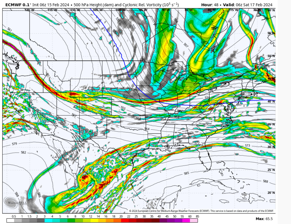
Check out this western ridge extension. Over the last couple of days we have seen this ridge trend stronger. In tandem with a -NAO (notice ridging over Greenland), its causing the Polar Vortex to stretch south and for the polar jet to sink into the eastern CONUS. We have the right signals. A -EPO, +PNA and -NAO.

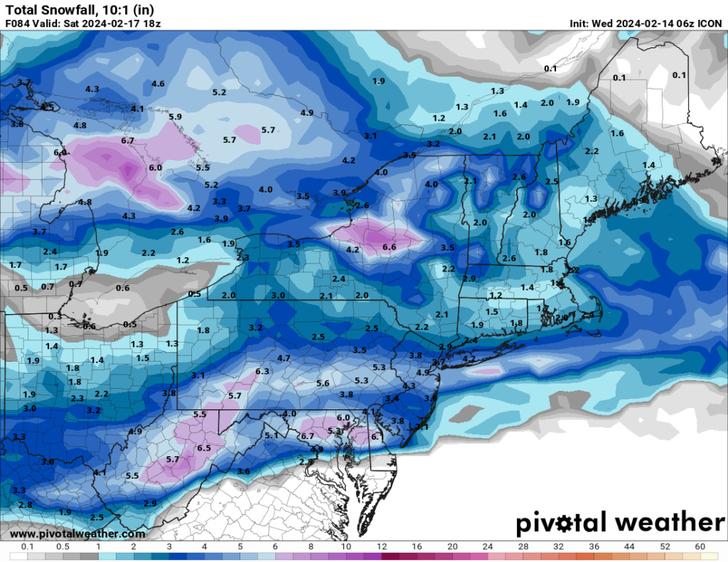
A look at the 500mb energy shows the pieces needed to come together for a storm to develop. We're tracking the sub-tropical energy, the pacific energy and the polar energy. These pieces are trying to consolidate near the Mid-Atlantic and models show a formidable storm system. Whether it comes up the coast or stays to our south is the question. Additionally, the size of the precip field, aka, how far north the snow gets, depends on dynamics and mid level lift. As of now, this is a system that favors southern portions of our area from DC-Philly to SNJ and as far north as Trenton.
Here is the Icon model's depiction of the snow threat. The timing is early Saturday morning (after Midnight) to 8am.

There is a CHANCE, we can see a better consolidation of all these piece of upper energy which could yield a much larger storm system. The timing for this one would be more Sunday into Monday. Not many models show this happening right now, but based on what I see aloft, its something we should keep an eye on.
This will be a baroclinic driven system where we have a deep arctic air mass clashing with a sub-tropical one.

Check out this western ridge extension. Over the last couple of days we have seen this ridge trend stronger. In tandem with a -NAO (notice ridging over Greenland), its causing the Polar Vortex to stretch south and for the polar jet to sink into the eastern CONUS. We have the right signals. A -EPO, +PNA and -NAO.

A look at the 500mb energy shows the pieces needed to come together for a storm to develop. We're tracking the sub-tropical energy, the pacific energy and the polar energy. These pieces are trying to consolidate near the Mid-Atlantic and models show a formidable storm system. Whether it comes up the coast or stays to our south is the question. Additionally, the size of the precip field, aka, how far north the snow gets, depends on dynamics and mid level lift. As of now, this is a system that favors southern portions of our area from DC-Philly to SNJ and as far north as Trenton.
Here is the Icon model's depiction of the snow threat. The timing is early Saturday morning (after Midnight) to 8am.

There is a CHANCE, we can see a better consolidation of all these piece of upper energy which could yield a much larger storm system. The timing for this one would be more Sunday into Monday. Not many models show this happening right now, but based on what I see aloft, its something we should keep an eye on.
sroc4, kalleg, essexcountypete, richb521, heehaw453, weatherwatchermom, SENJsnowman and JT33 like this post
 Re: Feb 2024 Observations and Discussion
To comment on Saturday's potential. It's n/s driven so while air mass will be colder the available moisture is more limited. The upside potential comes with possible slowing down of the s/w due to Atlantic blocking and/or more interaction with the sub tropical jet. Either of those puts this threat much higher. The air mass won't be a problem this go around.
h5 anomaly

700mb moisture transport

h5 anomaly

700mb moisture transport

heehaw453- Advanced Forecaster

- Posts : 3906
Reputation : 86
Join date : 2014-01-20
Location : Bedminster Township, PA Elevation 600' ASL

aiannone- Senior Enthusiast - Mod

- Posts : 4815
Reputation : 92
Join date : 2013-01-07
Location : Saint James, LI (Northwest Suffolk Co.)
 Re: Feb 2024 Observations and Discussion
Here's my two cents.
Like Frank mentions above there is a n/s energy, a Pac energy, and s/s energy. There are several things that need to shuffle around for a more sig event to unfold. First and foremost Id like to see the n/s energy trend slower and/or the Pac energy trend a tad faster. We need the Pac energy to get out ahead or at least in line with of the Pac energy. (blue line to the black X) As it stands now as you can see its behind it, (black line connecting n/s to Pac). As it stands now this positioning causes the n/s energy to press on the Pac and s/s energy and keeping it south instead of interacting with and amplifying it.
The second problem I'm seeing is wave spacing between the n/s and the clipper energy that passes through Thursday-ish. There is not a whole lot of room for things to amplify in between the two even if we get better n/s and Pac energy positioning or interaction.
And third is Im not seeing any meaningful consolidated vort max/energy coming out of the STJ, so like Frank mentions its more of a feature set up for baroclinically driven vertical motion. These sorts of dynamics are not very easy to see on an op model. The finer details often need the hi res in tight window to see the details of.
There are things like high ratios to consider, etc that could still end of working out. In general a stronger storm means a bigger gradient of those ratios, and visa versa. For now I think its best to not get caught up in any one type of soln or statement by others outside this board as there are many moving parts, many of which are very diff from our last set up, so lets see what the next24-48 hr trends look like.

_________________
"In weather and in life, there's no winning and losing; there's only winning and learning."
WINTER 2012/2013 TOTALS 43.65"WINTER 2017/2018 TOTALS 62.85" WINTER 2022/2023 TOTALS 4.9"
WINTER 2013/2014 TOTALS 64.85"WINTER 2018/2019 TOTALS 14.25" WINTER 2023/2024 TOTALS 13.1"
WINTER 2014/2015 TOTALS 71.20"WINTER 2019/2020 TOTALS 6.35"
WINTER 2015/2016 TOTALS 35.00"WINTER 2020/2021 TOTALS 37.75"
WINTER 2016/2017 TOTALS 42.25"WINTER 2021/2022 TOTALS 31.65"

sroc4- Admin

- Posts : 8354
Reputation : 302
Join date : 2013-01-07
Location : Wading River, LI
heehaw453- Advanced Forecaster

- Posts : 3906
Reputation : 86
Join date : 2014-01-20
Location : Bedminster Township, PA Elevation 600' ASL
 Re: Feb 2024 Observations and Discussion
If you can tap the subtropical jet with this you'd be looking at a real nice event for many. Not sure the PAC disturbance is enough moisture.
The NAO is going through a waning period so IMO further south track (DC/Baltimore) is a bit less likely. Think the Atlantic trough moves a bit which can help slow the s/w down, but give it enough room to come track enough north. Definitely potential...
The NAO is going through a waning period so IMO further south track (DC/Baltimore) is a bit less likely. Think the Atlantic trough moves a bit which can help slow the s/w down, but give it enough room to come track enough north. Definitely potential...
heehaw453- Advanced Forecaster

- Posts : 3906
Reputation : 86
Join date : 2014-01-20
Location : Bedminster Township, PA Elevation 600' ASL
 Re: Feb 2024 Observations and Discussion
sroc4 wrote:Here's my two cents.
Like Frank mentions above there is a n/s energy, a Pac energy, and s/s energy. There are several things that need to shuffle around for a more sig event to unfold. First and foremost Id like to see the n/s energy trend slower and/or the Pac energy trend a tad faster. We need the Pac energy to get out ahead or at least in line with of the Pac energy. (blue line to the black X) As it stands now as you can see its behind it, (black line connecting n/s to Pac). As it stands now this positioning causes the n/s energy to press on the Pac and s/s energy and keeping it south instead of interacting with and amplifying it.
The second problem I'm seeing is wave spacing between the n/s and the clipper energy that passes through Thursday-ish. There is not a whole lot of room for things to amplify in between the two even if we get better n/s and Pac energy positioning or interaction.
And third is Im not seeing any meaningful consolidated vort max/energy coming out of the STJ, so like Frank mentions its more of a feature set up for baroclinically driven vertical motion. These sorts of dynamics are not very easy to see on an op model. The finer details often need the hi res in tight window to see the details of.
There are things like high ratios to consider, etc that could still end of working out. In general a stronger storm means a bigger gradient of those ratios, and visa versa. For now I think its best to not get caught up in any one type of soln or statement by others outside this board as there are many moving parts, many of which are very diff from our last set up, so lets see what the next24-48 hr trends look like.
Here is a great example of what Im talking about. 12z rgem shows our Pac energy out ahead of the n/s. The result is some interactions such that we raise height a bit resulting in a sub 1000mb system off the coast.


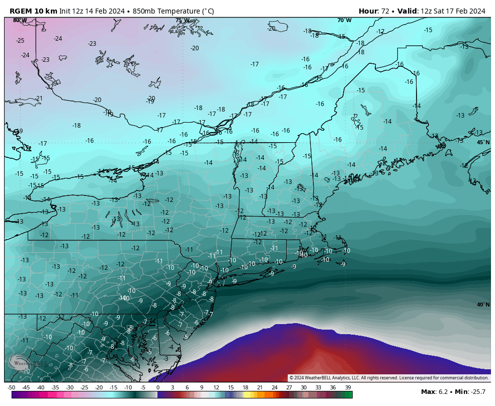


And remember this is high ratio snow fall. See the QPF image above( does not include thurs/fri clipper) and multiply the number over your house by 15 then 30 and that gives an approx range of what to expect snow total wise relative to where you live. For example if you see 0.2" of QPF you might see 3-6" of snow with that ratio range. Grain of salt because obv no details in focus now but you get the point.
_________________
"In weather and in life, there's no winning and losing; there's only winning and learning."
WINTER 2012/2013 TOTALS 43.65"WINTER 2017/2018 TOTALS 62.85" WINTER 2022/2023 TOTALS 4.9"
WINTER 2013/2014 TOTALS 64.85"WINTER 2018/2019 TOTALS 14.25" WINTER 2023/2024 TOTALS 13.1"
WINTER 2014/2015 TOTALS 71.20"WINTER 2019/2020 TOTALS 6.35"
WINTER 2015/2016 TOTALS 35.00"WINTER 2020/2021 TOTALS 37.75"
WINTER 2016/2017 TOTALS 42.25"WINTER 2021/2022 TOTALS 31.65"

sroc4- Admin

- Posts : 8354
Reputation : 302
Join date : 2013-01-07
Location : Wading River, LI
 Re: Feb 2024 Observations and Discussion
The GFS 12Z is close to a nice event for area IMO. Just a little further lift north of the sub tropical jet would do it. It may be picking up on a relaxation of the subtropical jet via higher SOI values (see below). The weaker the st jet IMO the less chance of a decent event for the area. There's a split jet depiction but unless the southern part is strong enough it's going to consolidate too far south. That's the key IMO to this system.
14 Feb 2024 1008.61 1008.00 -19.84 -14.48 -5.57
13 Feb 2024 1007.06 1007.95 -27.04 -12.77 -5.46
12 Feb 2024 1005.08 1008.15 -37.51 -10.99 -5.33
11 Feb 2024 1005.21 1008.95 -40.73 -8.94 -5.15
10 Feb 2024 1005.61 1009.10 -39.53 -7.15 -5.06
9 Feb 2024 1003.50 1008.45 -46.54 -5.57 -4.93
8 Feb 2024 1005.88 1007.85 -32.23 -3.97 -4.64
7 Feb 2024 1005.31 1008.70 -39.05 -2.84 -4.42

heehaw453- Advanced Forecaster

- Posts : 3906
Reputation : 86
Join date : 2014-01-20
Location : Bedminster Township, PA Elevation 600' ASL
MattyICE likes this post
 Re: Feb 2024 Observations and Discussion
I read elsewhere that the Fri night/Sat morning trends north tomorrow, strengthens and drops plowable snow. Finally an event that will actually have high ratios and most likely impressive mid and upper level dynamics and likely an impressive heavy snow band with it. The fact that the RGEM is amped is a red flag it’s dropping over 2 inches at just 10:1 ratios.
Thoughts?
Thoughts?

Irish- Pro Enthusiast

- Posts : 788
Reputation : 19
Join date : 2019-01-16
Age : 45
Location : Old Bridge, NJ
jmanley32 likes this post
 Re: Feb 2024 Observations and Discussion
So this is a Sat into Sat night system? Is there a chance it bumps north kust a bit, rn I am too close to the substantial cut off to feel safe, still what 4 days out and curious why are we suddenly using the icon and rgem so early?

jmanley32- Senior Enthusiast

- Posts : 20535
Reputation : 108
Join date : 2013-12-12
Age : 43
Location : Yonkers, NY
 Re: Feb 2024 Observations and Discussion
I read somewhere that this will be a true NYC special. A sub-freezing high ratio snow that will yield at least 6 inches of actual accumulation and doesn't melt to slop as soon as it touches the surface. Unfortunately with this storm it'll be mostly sunny outside of the city limits (inclusive of Jersey City for Frank's benefit).
Sorry for my rant - throw this in banter if needed. I'm so desperate to have similar photo-worthy moments most of the board has experienced so far this year!
Sorry for my rant - throw this in banter if needed. I'm so desperate to have similar photo-worthy moments most of the board has experienced so far this year!

crippo84- Posts : 383
Reputation : 20
Join date : 2013-11-07
Age : 40
Location : East Village, NYC
 Re: Feb 2024 Observations and Discussion
Where did you read it would be a NYC special, I am close enough that would likely include my area too, it would be razor sharp if not. Which it kinda was for the last one in terms of you losing out, I get your frustration. Hopefully we both cash in.crippo84 wrote:I read somewhere that this will be a true NYC special. A sub-freezing high ratio snow that will yield at least 6 inches of actual accumulation and doesn't melt to slop as soon as it touches the surface. Unfortunately with this storm it'll be mostly sunny outside of the city limits (inclusive of Jersey City for Frank's benefit).
Sorry for my rant - throw this in banter if needed. I'm so desperate to have similar photo-worthy moments most of the board has experienced so far this year!

jmanley32- Senior Enthusiast

- Posts : 20535
Reputation : 108
Join date : 2013-12-12
Age : 43
Location : Yonkers, NY
crippo84 likes this post
 Re: Feb 2024 Observations and Discussion
Cart before the horse friends. Nothing says NYC even has to see a flake out of this. Proceed with caution. Would look for any favorable trends to start showing up overnight into tmw if they’re going to. However, as we just saw, it’ll be hard to trust modeling on anything for a while.
MattyICE- Advanced Forecaster

- Posts : 249
Reputation : 6
Join date : 2017-11-10
Age : 38
Location : Clifton, NJ (Eastern Passaic County)
crippo84 and Irish like this post
 Re: Feb 2024 Observations and Discussion
heehaw453 wrote:The GFS 12Z is close to a nice event for area IMO. Just a little further lift north of the sub tropical jet would do it. It may be picking up on a relaxation of the subtropical jet via higher SOI values (see below). The weaker the st jet IMO the less chance of a decent event for the area. There's a split jet depiction but unless the southern part is strong enough it's going to consolidate too far south. That's the key IMO to this system.
14 Feb 2024 1008.61 1008.00 -19.84 -14.48 -5.57
13 Feb 2024 1007.06 1007.95 -27.04 -12.77 -5.46
12 Feb 2024 1005.08 1008.15 -37.51 -10.99 -5.33
11 Feb 2024 1005.21 1008.95 -40.73 -8.94 -5.15
10 Feb 2024 1005.61 1009.10 -39.53 -7.15 -5.06
9 Feb 2024 1003.50 1008.45 -46.54 -5.57 -4.93
8 Feb 2024 1005.88 1007.85 -32.23 -3.97 -4.64
7 Feb 2024 1005.31 1008.70 -39.05 -2.84 -4.42
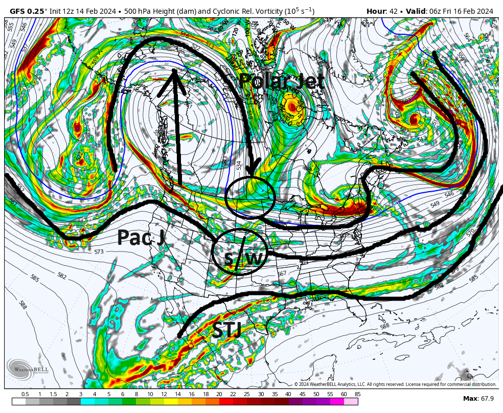
So when I refer to the STJ(sub tropical jet stream), or Pac Jet stream, or Polar Jet stream, I usually am referring to them at the 500mb level as this is typically where the vorticity/energy lives that leads to our slp. Contrast that with the 300mb level, for instance when I was referring to the "dual jet structure". With this level I may refer to the right rear quadrant of the northern JS(Jet streak), or left front quad to the southern JS(jet streak). These features are enhancers to the deepening of the slp based on their orientation with respect to the slp, but not necessarily what generates the slp in the first place like the vort max at the 500mb level. So with that your map you posted is the 300mb map. IMHO with this set up as of the way models have things now, obv this could change, there is very little if any tru STJ stream involvement at the 500mb level. See below. This seems to me that there is a s/w (shortwave) embedded within the Pac J that will hopefully interact with the n/s stream energy embedded and digging in compliments of that huge -EPO ridge via the Polar jet. The energy embedded within the STJ seems to, by and large, remain independent of the interactions between the PAc J and the Polar J with this system. If this persists then there is def a limit as to how strong a strom we really can get because even the Pac J energy gets strung out as the n/s and Pac s/w interact.


_________________
"In weather and in life, there's no winning and losing; there's only winning and learning."
WINTER 2012/2013 TOTALS 43.65"WINTER 2017/2018 TOTALS 62.85" WINTER 2022/2023 TOTALS 4.9"
WINTER 2013/2014 TOTALS 64.85"WINTER 2018/2019 TOTALS 14.25" WINTER 2023/2024 TOTALS 13.1"
WINTER 2014/2015 TOTALS 71.20"WINTER 2019/2020 TOTALS 6.35"
WINTER 2015/2016 TOTALS 35.00"WINTER 2020/2021 TOTALS 37.75"
WINTER 2016/2017 TOTALS 42.25"WINTER 2021/2022 TOTALS 31.65"

sroc4- Admin

- Posts : 8354
Reputation : 302
Join date : 2013-01-07
Location : Wading River, LI
 Re: Feb 2024 Observations and Discussion
jmanley32 wrote:Where did you read it would be a NYC special, I am close enough that would likely include my area too, it would be razor sharp if not. Which it kinda was for the last one in terms of you losing out, I get your frustration. Hopefully we both cash in.crippo84 wrote:I read somewhere that this will be a true NYC special. A sub-freezing high ratio snow that will yield at least 6 inches of actual accumulation and doesn't melt to slop as soon as it touches the surface. Unfortunately with this storm it'll be mostly sunny outside of the city limits (inclusive of Jersey City for Frank's benefit).
Sorry for my rant - throw this in banter if needed. I'm so desperate to have similar photo-worthy moments most of the board has experienced so far this year!
My source of information is solely my imagination. Carry on with the discussion. I mean... We Track!


crippo84- Posts : 383
Reputation : 20
Join date : 2013-11-07
Age : 40
Location : East Village, NYC
docstox12 likes this post
 Re: Feb 2024 Observations and Discussion
LOL, oh, no misleading the shareholders..another good word is fraud! I think the real crime is the beard! (If you know what this quote is from big thumbs up).crippo84 wrote:jmanley32 wrote:Where did you read it would be a NYC special, I am close enough that would likely include my area too, it would be razor sharp if not. Which it kinda was for the last one in terms of you losing out, I get your frustration. Hopefully we both cash in.crippo84 wrote:I read somewhere that this will be a true NYC special. A sub-freezing high ratio snow that will yield at least 6 inches of actual accumulation and doesn't melt to slop as soon as it touches the surface. Unfortunately with this storm it'll be mostly sunny outside of the city limits (inclusive of Jersey City for Frank's benefit).
Sorry for my rant - throw this in banter if needed. I'm so desperate to have similar photo-worthy moments most of the board has experienced so far this year!
My source of information is solely my imagination. Carry on with the discussion. I mean... We Track!

jmanley32- Senior Enthusiast

- Posts : 20535
Reputation : 108
Join date : 2013-12-12
Age : 43
Location : Yonkers, NY
 Re: Feb 2024 Observations and Discussion
sroc4 wrote:heehaw453 wrote:The GFS 12Z is close to a nice event for area IMO. Just a little further lift north of the sub tropical jet would do it. It may be picking up on a relaxation of the subtropical jet via higher SOI values (see below). The weaker the st jet IMO the less chance of a decent event for the area. There's a split jet depiction but unless the southern part is strong enough it's going to consolidate too far south. That's the key IMO to this system.
14 Feb 2024 1008.61 1008.00 -19.84 -14.48 -5.57
13 Feb 2024 1007.06 1007.95 -27.04 -12.77 -5.46
12 Feb 2024 1005.08 1008.15 -37.51 -10.99 -5.33
11 Feb 2024 1005.21 1008.95 -40.73 -8.94 -5.15
10 Feb 2024 1005.61 1009.10 -39.53 -7.15 -5.06
9 Feb 2024 1003.50 1008.45 -46.54 -5.57 -4.93
8 Feb 2024 1005.88 1007.85 -32.23 -3.97 -4.64
7 Feb 2024 1005.31 1008.70 -39.05 -2.84 -4.42
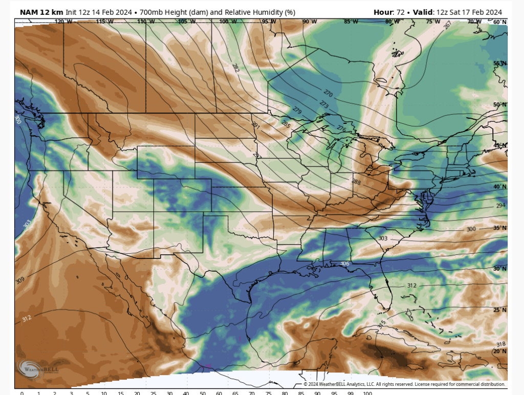
So when I refer to the STJ(sub tropical jet stream), or Pac Jet stream, or Polar Jet stream, I usually am referring to them at the 500mb level as this is typically where the vorticity/energy lives that leads to our slp. Contrast that with the 300mb level, for instance when I was referring to the "dual jet structure". With this level I may refer to the right rear quadrant of the northern JS(Jet streak), or left front quad to the southern JS(jet streak). These features are enhancers to the deepening of the slp based on their orientation with respect to the slp, but not necessarily what generates the slp in the first place like the vort max at the 500mb level. So with that your map you posted is the 300mb map. IMHO with this set up as of the way models have things now, obv this could change, there is very little if any tru STJ stream involvement at the 500mb level. See below. This seems to me that there is a s/w (shortwave) embedded within the Pac J that will hopefully interact with the n/s stream energy embedded and digging in compliments of that huge -EPO ridge via the Polar jet. The energy embedded within the STJ seems to, by and large, remain independent of the interactions between the PAc J and the Polar J with this system. If this persists then there is def a limit as to how strong a strom we really can get because even the Pac J energy gets strung out as the n/s and Pac s/w interact.
On some models it does remain largely independent. GFS clearly is but things like NAM are not. To your point the s/w must get out of the trough far enough to allow heights to rise, but I don't think it's going to have enough moisture w/out some STJ interaction to produce much. Ratios will be good so it won't take but .2" QPF for a 3-4" event, but i wouldn't go any higher than 20:1 especially on the immediate coast as above that is a rare bird for ratios. In order for bigger solutions we need moisture and I think STJ holds the answer.
heehaw453- Advanced Forecaster

- Posts : 3906
Reputation : 86
Join date : 2014-01-20
Location : Bedminster Township, PA Elevation 600' ASL
sroc4 and jmanley32 like this post
 Re: Feb 2024 Observations and Discussion
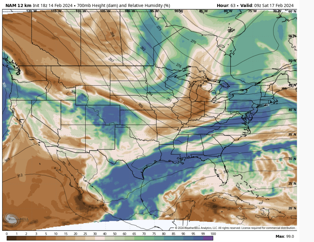
18Z NAM regarding Saturday. There won't be a lot of interaction with the STJ, but just enough is what's needed. Any deviation in model strength of that STJ IMO has large implications on moisture content. Sroc and I are not contradicting one another but complementing IMO. His points are spot on regarding the pac s/w running out ahead of the n/s.


heehaw453- Advanced Forecaster

- Posts : 3906
Reputation : 86
Join date : 2014-01-20
Location : Bedminster Township, PA Elevation 600' ASL
 Re: Feb 2024 Observations and Discussion
jmanley32 wrote:
LOL, oh, no misleading the shareholders..another good word is fraud! I think the real crime is the beard! (If you know what this quote is from big thumbs up).
Oscar Martinez over here.
Anything on the horizon beyond Saturday? I prefer things during the week because maybe I get the chance to work from home, haha.
sabamfa- Pro Enthusiast

- Posts : 246
Reputation : 2
Join date : 2013-11-05
Age : 38
Location : Wayne, NJ
weatherwatchermom likes this post
 Re: Feb 2024 Observations and Discussion
Nice! You got it. Me too, I work from home 2 days already so to have 2 in a row was nice. Next is Friday. (I picked the day with our staff meeting (1 hour less of actual work, Wed) and Fridays, no commute and I can start my weekend as soon as I turn that zoom off. And my last client (I am a mental health therapist) of the day is a very fun to work with 17 year old girl, though she does have a lot of tough issues (thats all I can say legally). As for future storms after the weekend I hope so too. Sorry I know this was mostly Banter, move if needed. To make it not banter I will say it is very cold, the heat is not coming on enough.sabamfa wrote:jmanley32 wrote:
LOL, oh, no misleading the shareholders..another good word is fraud! I think the real crime is the beard! (If you know what this quote is from big thumbs up).
Oscar Martinez over here.
Anything on the horizon beyond Saturday? I prefer things during the week because maybe I get the chance to work from home, haha.

jmanley32- Senior Enthusiast

- Posts : 20535
Reputation : 108
Join date : 2013-12-12
Age : 43
Location : Yonkers, NY
 Re: Feb 2024 Observations and Discussion
heehaw453 wrote:18Z NAM regarding Saturday. There won't be a lot of interaction with the STJ, but just enough is what's needed. Any deviation in model strength of that STJ IMO has large implications on moisture content. Sroc and I are not contradicting one another but complementing IMO. His points are spot on regarding the pac s/w running out ahead of the n/s.
There is something not quite right about the NAM. I noticed this too on 12z. Not sure if this is the case on other sites but the weatherbell maps the surface temp profiles seem wonky. Riddle me this. Below I will show three images from Hr 63, as the snow breaks out, and the current surface temps and 850mb temps. Pay particular attention to where the low is, ie: over the Delmarva. Ok so at the onset the 32* lines on he surface is way down south past NJ, and 850s are plenty cold. One would surmise as has always been the case that the counterclockwise flow around a surface low would have a southerly flow out ahead. In theory this should be the warmest the coastal p-lain would be as the Low heads S&E of LI. Normally as it moves towards the BM the winds com around out of the NW bringing with it the cold air right?


Now Pay particular atention to the coastal plain surface temps over the net several frames as the low passes S&E


The only thing I can surmise is sun angle. The images start at approx 4 am up top and finish at about 4pm last image above. We may have to keep an eye on this. I have to say I am not buying a temp that starts at 31-32* on LI at 4 am with a NW wind throughout the entire atmospehere between the surface and at least 850mb and the temp spikes to the upper 30's. Again something isnt right.
_________________
"In weather and in life, there's no winning and losing; there's only winning and learning."
WINTER 2012/2013 TOTALS 43.65"WINTER 2017/2018 TOTALS 62.85" WINTER 2022/2023 TOTALS 4.9"
WINTER 2013/2014 TOTALS 64.85"WINTER 2018/2019 TOTALS 14.25" WINTER 2023/2024 TOTALS 13.1"
WINTER 2014/2015 TOTALS 71.20"WINTER 2019/2020 TOTALS 6.35"
WINTER 2015/2016 TOTALS 35.00"WINTER 2020/2021 TOTALS 37.75"
WINTER 2016/2017 TOTALS 42.25"WINTER 2021/2022 TOTALS 31.65"

sroc4- Admin

- Posts : 8354
Reputation : 302
Join date : 2013-01-07
Location : Wading River, LI
 Re: Feb 2024 Observations and Discussion
Lets get that .4 qpf bumped north, we dont have many folks down there do we? That would be possibly 8 inches with ratios no? IMO with how wet things have been the qpf will likely be higher, though I know if it gets too cold and ratios get too high that it can sometimes suppress snowfall, is that true?heehaw453 wrote:18Z NAM regarding Saturday. There won't be a lot of interaction with the STJ, but just enough is what's needed. Any deviation in model strength of that STJ IMO has large implications on moisture content. Sroc and I are not contradicting one another but complementing IMO. His points are spot on regarding the pac s/w running out ahead of the n/s.

jmanley32- Senior Enthusiast

- Posts : 20535
Reputation : 108
Join date : 2013-12-12
Age : 43
Location : Yonkers, NY

Irish- Pro Enthusiast

- Posts : 788
Reputation : 19
Join date : 2019-01-16
Age : 45
Location : Old Bridge, NJ
jmanley32 likes this post
 Re: Feb 2024 Observations and Discussion
Time to start a thread for Friday into Saturday?

Irish- Pro Enthusiast

- Posts : 788
Reputation : 19
Join date : 2019-01-16
Age : 45
Location : Old Bridge, NJ
 Re: Feb 2024 Observations and Discussion
13.3 was the low. Nice snow pack to cool the air.
heehaw453- Advanced Forecaster

- Posts : 3906
Reputation : 86
Join date : 2014-01-20
Location : Bedminster Township, PA Elevation 600' ASL
heehaw453- Advanced Forecaster

- Posts : 3906
Reputation : 86
Join date : 2014-01-20
Location : Bedminster Township, PA Elevation 600' ASL
essexcountypete likes this post
Page 2 of 6 •  1, 2, 3, 4, 5, 6
Permissions in this forum:
You cannot reply to topics in this forum|
|
|

 Home
Home
