
 Search
March 17th-18th Storm Potential Discussion
Page 15 of 21 •  1 ... 9 ... 14, 15, 16 ... 21
 ![]()
Re: March 17th-18th Storm Potential Discussion
![]() by algae888 Fri Mar 14, 2014 4:27 pm
by algae888 Fri Mar 14, 2014 4:27 pm
algae888- Advanced Forecaster

- Posts : 5311
Join date : 2013-02-05
Re: March 17th-18th Storm Potential Discussion
![]() by jmanley32 Fri Mar 14, 2014 4:29 pm
by jmanley32 Fri Mar 14, 2014 4:29 pm
jmanley32- Senior Enthusiast

- Posts : 20516
Join date : 2013-12-12
Re: March 17th-18th Storm Potential Discussion
![]() by jmanley32 Fri Mar 14, 2014 4:35 pm
by jmanley32 Fri Mar 14, 2014 4:35 pm

jmanley32- Senior Enthusiast
- Posts : 20516
Reputation : 108
Join date : 2013-12-12
Age : 42
Location : Yonkers, NY
Re: March 17th-18th Storm Potential Discussion
![]() by pdubz Fri Mar 14, 2014 4:36 pm
by pdubz Fri Mar 14, 2014 4:36 pm

Last edited by pdubz on Fri Mar 14, 2014 4:42 pm; edited 1 time in total

pdubz- Pro Enthusiast

- Posts : 539
Reputation : 0
Join date : 2013-09-24
Age : 32
Location : Port Washington,NY (L.I)
Re: March 17th-18th Storm Potential Discussion
![]() by jmanley32 Fri Mar 14, 2014 4:37 pm
by jmanley32 Fri Mar 14, 2014 4:37 pm
jmanley32- Senior Enthusiast
- Posts : 20516
Reputation : 108
Join date : 2013-12-12
Age : 42
Location : Yonkers, NY
Re: March 17th-18th Storm Potential Discussion
![]() by WOLVES1 Fri Mar 14, 2014 4:40 pm
by WOLVES1 Fri Mar 14, 2014 4:40 pm

WOLVES1- Posts : 103
Reputation : 0
Join date : 2013-01-10
Age : 52
Location : Malverne NY
Re: March 17th-18th Storm Potential Discussion
![]() by jmanley32 Fri Mar 14, 2014 4:40 pm
by jmanley32 Fri Mar 14, 2014 4:40 pm
jmanley32- Senior Enthusiast
- Posts : 20516
Reputation : 108
Join date : 2013-12-12
Age : 42
Location : Yonkers, NY
Re: March 17th-18th Storm Potential Discussion
![]() by pdubz Fri Mar 14, 2014 4:43 pm
by pdubz Fri Mar 14, 2014 4:43 pm
jmanley32 wrote:pdubz i like the NAM its in range for the beginning part so its looking better and better, but if the other models do not do much tonight or tomorrow ill be concerned.
yeah things need to work out perfectly
pdubz- Pro Enthusiast
- Posts : 539
Reputation : 0
Join date : 2013-09-24
Age : 32
Location : Port Washington,NY (L.I)
Re: March 17th-18th Storm Potential Discussion
![]() by jmanley32 Fri Mar 14, 2014 4:43 pm
by jmanley32 Fri Mar 14, 2014 4:43 pm
jmanley32- Senior Enthusiast
- Posts : 20516
Reputation : 108
Join date : 2013-12-12
Age : 42
Location : Yonkers, NY
Re: March 17th-18th Storm Potential Discussion
![]() by jmanley32 Fri Mar 14, 2014 4:47 pm
by jmanley32 Fri Mar 14, 2014 4:47 pm
jmanley32- Senior Enthusiast
- Posts : 20516
Reputation : 108
Join date : 2013-12-12
Age : 42
Location : Yonkers, NY
Re: March 17th-18th Storm Potential Discussion
![]() by dad4twoboys Fri Mar 14, 2014 4:55 pm
by dad4twoboys Fri Mar 14, 2014 4:55 pm
"90% chance of weather Monday"
dad4twoboys- Pro Enthusiast
- Posts : 200
Reputation : 12
Join date : 2013-01-08
Location : Brewster, New York -

Re: March 17th-18th Storm Potential Discussion
![]() by Abba701 Fri Mar 14, 2014 4:57 pm
by Abba701 Fri Mar 14, 2014 4:57 pm
http://myforecast.com/bin/expanded_forecast_15day.m?city=24384&zip_code=11213&metric=false
Abba701- Posts : 328
Reputation : 0
Join date : 2013-01-14
Re: March 17th-18th Storm Potential Discussion
![]() by jmanley32 Fri Mar 14, 2014 4:57 pm
by jmanley32 Fri Mar 14, 2014 4:57 pm
jmanley32- Senior Enthusiast
- Posts : 20516
Reputation : 108
Join date : 2013-12-12
Age : 42
Location : Yonkers, NY
Re: March 17th-18th Storm Potential Discussion
![]() by SNOW MAN Fri Mar 14, 2014 5:00 pm
by SNOW MAN Fri Mar 14, 2014 5:00 pm
CPcantmeasuresnow wrote:SNOW MAN wrote:CPcantmeasuresnow wrote:All kidding aside I still don't believe, or accept this one is dead yet. I can't accept that we will be screwed this many times in such a short time period, it doesn't seem mathematically probable, but I have nothing to base it on other than that.
Of course the evil thread is dead, and that doesn't hurt either.
Face it CP all bad things come in three's. We had 2 misses so far this month and you know what that means "IT'S OVER JOHNNY" !!!Believe me I hate to see this season end this way, but I have a feeling that we will not be seeing anymore snow until next season. HOW DEPRESSING.
Refuse to lose!!
but just in case send me your snow therapists number.
I'll see if I can get a group rate.
psssst, you know what I'm doing right. I'm trying the old r-----e p--------y approach.

SNOW MAN- Senior Enthusiast
- Posts : 1361
Reputation : 25
Join date : 2013-01-13
Age : 64
Location : Marshalls Creek Pa.
Re: March 17th-18th Storm Potential Discussion
![]() by jmanley32 Fri Mar 14, 2014 5:14 pm
by jmanley32 Fri Mar 14, 2014 5:14 pm
jmanley32- Senior Enthusiast
- Posts : 20516
Reputation : 108
Join date : 2013-12-12
Age : 42
Location : Yonkers, NY
Re: March 17th-18th Storm Potential Discussion
![]() by amugs Fri Mar 14, 2014 5:18 pm
by amugs Fri Mar 14, 2014 5:18 pm
Okay let's keep the faith here guys and if she fails us as the old Italians believe that things happen in three's like Snow said. But for just a but we wait to get some sampling of the energy by tonight 0z runs by tomorrow's 6Z runs which puts us within the 48 hours range.SNOW MAN wrote:CPcantmeasuresnow wrote:SNOW MAN wrote:CPcantmeasuresnow wrote:All kidding aside I still don't believe, or accept this one is dead yet. I can't accept that we will be screwed this many times in such a short time period, it doesn't seem mathematically probable, but I have nothing to base it on other than that.
Of course the evil thread is dead, and that doesn't hurt either.
Face it CP all bad things come in three's. We had 2 misses so far this month and you know what that means "IT'S OVER JOHNNY" !!!
Refuse to lose!!
but just in case send me your snow therapists number.
I'll see if I can get a group rate.
psssst, you know what I'm doing right. I'm trying the old r-----e p--------y approach.
If I may the KSW may need the shrink as well if this goes poof! That a bottle of Single Barrel Vault #58 to help ease my suffering!
_________________
Mugs
AKA:King: Snow Weenie
Self Proclaimed
WINTER 2014-15 : 55.12" +.02 for 6 coatings (avg. 35")
WINTER 2015-16 Total - 29.8" (Avg 35")
WINTER 2016-17 : 39.5" so far

amugs- Advanced Forecaster - Mod

- Posts : 15093
Reputation : 213
Join date : 2013-01-07
Age : 54
Location : Hillsdale,NJ
Re: March 17th-18th Storm Potential Discussion
![]() by amugs Fri Mar 14, 2014 5:21 pm
by amugs Fri Mar 14, 2014 5:21 pm
_________________
Mugs
AKA:King: Snow Weenie
Self Proclaimed
WINTER 2014-15 : 55.12" +.02 for 6 coatings (avg. 35")
WINTER 2015-16 Total - 29.8" (Avg 35")
WINTER 2016-17 : 39.5" so far
amugs- Advanced Forecaster - Mod
- Posts : 15093
Reputation : 213
Join date : 2013-01-07
Age : 54
Location : Hillsdale,NJ
Re: March 17th-18th Storm Potential Discussion
![]() by Quietace Fri Mar 14, 2014 5:22 pm
by Quietace Fri Mar 14, 2014 5:22 pm
Last edited by Quietace on Fri Mar 14, 2014 5:23 pm; edited 1 time in total

Quietace- Meteorologist - Mod

- Posts : 3687
Reputation : 33
Join date : 2013-01-07
Age : 27
Location : Point Pleasant, NJ
Re: March 17th-18th Storm Potential Discussion
![]() by sroc4 Fri Mar 14, 2014 5:22 pm
by sroc4 Fri Mar 14, 2014 5:22 pm
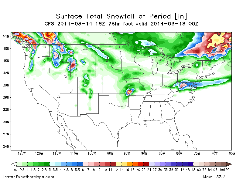
THE 00Z/14 DETERMINISTIC RUNS CONTINUED TO SHOW A NORTHERN TREND IN THE TRACK WHICH CONTINUES TO SUPPORT THE IDEA FROM SUNY SB SENSITIVITY ANALYSIS...HOWEVER TODAYS 12Z MODEL SUITE HAS INTERESTINGLY SHIFTED SOUTH. THIS INCONSISTENCY STEMS FROM THE INTERACTION BETWEEN THE SHORTWAVE TROUGH THAT JUST MOVED ONSHORE IN THE PAC NW AND THE SOUTHERN STREAM TROUGH/CUTOFF LOW OVER THE SW US. DEGREE OF PHASING OF THESE TWO FEATURES...AND EJECTION OF SHORTWAVE ENERGY FROM THIS TROUGH AND THE EVENTUAL PROGRESSION OF THE TROUGH ITSELF...WILL DETERMINE EVENTUAL IMPACTS TO THE AREA. ALSO NEED TO KEEP AN EYE ON THE STRENGTH OF THE CANADIAN HIGH BUILDING IN TO THE NORTH AS IT COULD BECOME THE MAIN PLAYER AND THE MARCH 3RD STORM OR BETTER THE NON-STORM IS STILL IN RECENT MEMORY. THE HIGH DURING THAT EVENT WAS ABOUT 10 MB STRONGER THAN IT IS CURRENTLY FORECAST TO BE FOR THIS ONE.
WHILE THE 00Z/14 GEFS..NAEFS AND EC ENS MEANS ARE IN GOOD AGREEMENT...THE 00Z/14 SENSITIVITY ANALYSIS IS STILL INDICATING A LARGE DEGREE OF SPREAD IN MSLP TO THE N OF EACH OF THE MEAN TRACKS...IMPLYING THAT THE TRACK WOULD BE FURTHER N. THE SENSITIVITY SIGNAL FIRST APPEARS ON LAND AT 00Z/15 AND APPEARS TO BE ASSOCIATED WITH THE SHORTWAVE IN THE PAC NW. WILL BE ABLE TO GAIN SOME BETTER INSIGHT AFTER TONIGHT`S 00Z AND EVEN MORE AFTER TOMORROWS 12Z RUNS NOW THAT THIS SHORTWAVE CAN BE SAMPLED MUCH BETTER BY UPPER AIR OBSERVATIONS. A COMPARISON OF THE AMPLITUDE OF THE H5 FLOW OVER THE ERN PACIFIC OCEAN AND PAC NW CAN BE MADE AS WELL AND DETERMINATION IF THESE NRN TRACK SOLNS ARE PLAUSIBLE OR NOT. THE COLD CANADIAN HIGH PRES BUILDING IN TO THE N WILL PROVIDE THE COLD AIR NEEDED FOR A SNOW EVENT...BUT THIS TOO COULD BECOME QUESTIONABLE ACROSS PORTIONS OF THE AREA IF THE SPREAD IN THE ENS MEANS COMES TO FRUITION.
AM NOT JUMPING ON THE SUPPRESSED SOLNS YET SINCE THERE ARE STILL MANY QUESTIONS TO BE ANSWERED...SO THE POTENTIAL FOR SEVERAL INCHES OF SNOW REMAINS POSSIBLE. NOT QUITE SURE IF WE WOULD BE ABLE TO REACH WARNING CRITERIA (6 INCHES) IN A OVERRUNNING PATTERN...BUT THE HIGHER QPF VALUES ARE JUST SOUTH OF THE AREA AND IT IS STILL COLD ENOUGH FOR SNOW.
_________________
"In weather and in life, there's no winning and losing; there's only winning and learning."
WINTER 2012/2013 TOTALS 43.65"WINTER 2017/2018 TOTALS 62.85" WINTER 2022/2023 TOTALS 4.9"
WINTER 2013/2014 TOTALS 64.85"WINTER 2018/2019 TOTALS 14.25" WINTER 2023/2024 TOTALS 13.1"
WINTER 2014/2015 TOTALS 71.20"WINTER 2019/2020 TOTALS 6.35"
WINTER 2015/2016 TOTALS 35.00"WINTER 2020/2021 TOTALS 37.75"
WINTER 2016/2017 TOTALS 42.25"WINTER 2021/2022 TOTALS 31.65"

sroc4- Admin

- Posts : 8331
Reputation : 301
Join date : 2013-01-07
Location : Wading River, LI
Re: March 17th-18th Storm Potential Discussion
![]() by amugs Fri Mar 14, 2014 5:28 pm
by amugs Fri Mar 14, 2014 5:28 pm
_________________
Mugs
AKA:King: Snow Weenie
Self Proclaimed
WINTER 2014-15 : 55.12" +.02 for 6 coatings (avg. 35")
WINTER 2015-16 Total - 29.8" (Avg 35")
WINTER 2016-17 : 39.5" so far
amugs- Advanced Forecaster - Mod
- Posts : 15093
Reputation : 213
Join date : 2013-01-07
Age : 54
Location : Hillsdale,NJ
Re: March 17th-18th Storm Potential Discussion
![]() by CPcantmeasuresnow Fri Mar 14, 2014 5:43 pm
by CPcantmeasuresnow Fri Mar 14, 2014 5:43 pm
SNOW MAN wrote:CPcantmeasuresnow wrote:SNOW MAN wrote:CPcantmeasuresnow wrote:All kidding aside I still don't believe, or accept this one is dead yet. I can't accept that we will be screwed this many times in such a short time period, it doesn't seem mathematically probable, but I have nothing to base it on other than that.
Of course the evil thread is dead, and that doesn't hurt either.
Face it CP all bad things come in three's. We had 2 misses so far this month and you know what that means "IT'S OVER JOHNNY" !!!
Refuse to lose!!
but just in case send me your snow therapists number.
I'll see if I can get a group rate.
You've done all you can soldier, if we lose this one it won't be for lack of innovative battle strategy.
psssst, you know what I'm doing right. I'm trying the old r-----e p--------y approach.

CPcantmeasuresnow- Wx Statistician Guru

- Posts : 7274
Reputation : 230
Join date : 2013-01-07
Age : 103
Location : Eastern Orange County, NY
Re: March 17th-18th Storm Potential Discussion
![]() by jmanley32 Fri Mar 14, 2014 5:44 pm
by jmanley32 Fri Mar 14, 2014 5:44 pm
jmanley32- Senior Enthusiast
- Posts : 20516
Reputation : 108
Join date : 2013-12-12
Age : 42
Location : Yonkers, NY
Re: March 17th-18th Storm Potential Discussion
![]() by dad4twoboys Fri Mar 14, 2014 5:46 pm
by dad4twoboys Fri Mar 14, 2014 5:46 pm
Last edited by dad4twoboys on Fri Mar 14, 2014 6:11 pm; edited 2 times in total
dad4twoboys- Pro Enthusiast
- Posts : 200
Reputation : 12
Join date : 2013-01-08
Location : Brewster, New York -
Re: March 17th-18th Storm Potential Discussion
![]() by jmanley32 Fri Mar 14, 2014 5:47 pm
by jmanley32 Fri Mar 14, 2014 5:47 pm
jmanley32- Senior Enthusiast
- Posts : 20516
Reputation : 108
Join date : 2013-12-12
Age : 42
Location : Yonkers, NY
Re: March 17th-18th Storm Potential Discussion
![]() by SNOW MAN Fri Mar 14, 2014 5:50 pm
by SNOW MAN Fri Mar 14, 2014 5:50 pm
 What da think ?
SNOW MAN- Senior Enthusiast
- Posts : 1361
Reputation : 25
Join date : 2013-01-13
Age : 64
Location : Marshalls Creek Pa.
Re: March 17th-18th Storm Potential Discussion
![]() by aiannone Fri Mar 14, 2014 5:54 pm
by aiannone Fri Mar 14, 2014 5:54 pm
_________________
-Alex Iannone-

aiannone- Senior Enthusiast - Mod
- Posts : 4814
Reputation : 92
Join date : 2013-01-07
Location : Saint James, LI (Northwest Suffolk Co.)
Re: March 17th-18th Storm Potential Discussion
![]() by aiannone Fri Mar 14, 2014 5:56 pm
by aiannone Fri Mar 14, 2014 5:56 pm
_________________
-Alex Iannone-
aiannone- Senior Enthusiast - Mod
- Posts : 4814
Reputation : 92
Join date : 2013-01-07
Location : Saint James, LI (Northwest Suffolk Co.)
Page 15 of 21 • 1 ... 9 ... 14, 15, 16 ... 21 ![]()
|
|
|