
 Search
Official Long Range Thread 3.0
Page 7 of 32 •  1 ... 6, 7, 8 ... 19 ... 32
 ![]()
Re: Official Long Range Thread 3.0
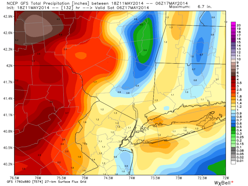
![]() by jmanley32 Sun May 11, 2014 3:06 pm
by jmanley32 Sun May 11, 2014 3:06 pm
jmanley32- Senior Enthusiast

- Posts : 20517
Join date : 2013-12-12
Re: Official Long Range Thread 3.0
![]() by algae888 Sun May 11, 2014 7:18 pm
by algae888 Sun May 11, 2014 7:18 pm
jmanley32 wrote:Yes, that seems the plan, the CMC is doing it again and stalling a low just south of here for days 993mb at 8-10 day range. Won't fall for this again, I give kudos to those who saw right through the CMC. Rain totals still dont look that impressive except on CMC and that seems to be enhanced by that supposed (not happening) stalled low around 20-21st.
CMC originally had the low for the 16th. it has lost that now has one later like you stated. I think its safe to say that we will not have a big storm later this week.
algae888- Advanced Forecaster

- Posts : 5311
Join date : 2013-02-05
Re: Official Long Range Thread 3.0
![]() by jmanley32 Sun May 11, 2014 7:40 pm
by jmanley32 Sun May 11, 2014 7:40 pm

jmanley32- Senior Enthusiast
- Posts : 20517
Reputation : 108
Join date : 2013-12-12
Age : 42
Location : Yonkers, NY
Re: Official Long Range Thread 3.0
![]() by Frank_Wx Sun May 11, 2014 9:28 pm
by Frank_Wx Sun May 11, 2014 9:28 pm


_________________
_______________________________________________________________________________________________________
CLICK HERE to view NJ Strong Snowstorm Classifications

Frank_Wx- Godzilla Seeker

- Posts : 21305
Reputation : 328
Join date : 2013-01-05
Age : 31
Location : Jersey City, NJ -

Re: Official Long Range Thread 3.0
![]() by Frank_Wx Sun May 11, 2014 11:49 pm
by Frank_Wx Sun May 11, 2014 11:49 pm

_________________
_______________________________________________________________________________________________________
CLICK HERE to view NJ Strong Snowstorm Classifications
Frank_Wx- Godzilla Seeker
- Posts : 21305
Reputation : 328
Join date : 2013-01-05
Age : 31
Location : Jersey City, NJ -
Re: Official Long Range Thread 3.0
![]() by jmanley32 Mon May 12, 2014 4:16 pm
by jmanley32 Mon May 12, 2014 4:16 pm
jmanley32- Senior Enthusiast
- Posts : 20517
Reputation : 108
Join date : 2013-12-12
Age : 42
Location : Yonkers, NY
Re: Official Long Range Thread 3.0
![]() by jmanley32 Mon May 12, 2014 7:03 pm
by jmanley32 Mon May 12, 2014 7:03 pm
jmanley32- Senior Enthusiast
- Posts : 20517
Reputation : 108
Join date : 2013-12-12
Age : 42
Location : Yonkers, NY
Re: Official Long Range Thread 3.0
![]() by Frank_Wx Mon May 19, 2014 10:06 am
by Frank_Wx Mon May 19, 2014 10:06 am
_________________
_______________________________________________________________________________________________________
CLICK HERE to view NJ Strong Snowstorm Classifications
Frank_Wx- Godzilla Seeker
- Posts : 21305
Reputation : 328
Join date : 2013-01-05
Age : 31
Location : Jersey City, NJ -
Re: Official Long Range Thread 3.0
![]() by oldtimer Mon May 19, 2014 4:36 pm
by oldtimer Mon May 19, 2014 4:36 pm
oldtimer- Senior Enthusiast
- Posts : 1103
Reputation : 14
Join date : 2013-01-16
Age : 78
Location : Port Jefferson Station Suffolk County
Re: Official Long Range Thread 3.0
![]() by Analog96 Tue May 20, 2014 11:13 am
by Analog96 Tue May 20, 2014 11:13 am
Frank_Wx wrote:Memorial weekend and Day isn't looking that great if you're venturing to the beach. As of now, GFS is suggesting temps ranging from upper 60's to low 70's with the threat of clouds and pop up showers all weekend due to an upper level disturbance sitting and spinning in northern New England. Let's see if future model runs can get that disturbance out of here sooner.
Friday could be a washout.
Saturday depends on wind direction- some modeling is showing onshore flow, which would limit temps, but also convection.
Sunday and Monday should be sunny and warm, especially Monday.
Analog96- Meteorologist

- Posts : 156
Reputation : 1
Join date : 2014-03-12
Location : Elizabeth, NJ
Re: Official Long Range Thread 3.0
![]() by Frank_Wx Thu May 22, 2014 7:52 pm
by Frank_Wx Thu May 22, 2014 7:52 pm
Analog96 wrote:Frank_Wx wrote:Memorial weekend and Day isn't looking that great if you're venturing to the beach. As of now, GFS is suggesting temps ranging from upper 60's to low 70's with the threat of clouds and pop up showers all weekend due to an upper level disturbance sitting and spinning in northern New England. Let's see if future model runs can get that disturbance out of here sooner.
Friday could be a washout.
Saturday depends on wind direction- some modeling is showing onshore flow, which would limit temps, but also convection.
Sunday and Monday should be sunny and warm, especially Monday.
This entire weekend there will be a threat for scattered showers and storms. It's a pretty unstable atmosphere. Monday does look like the best day, partly cloudy and temps around 80 degrees. But after Monday, it's back to unsettled weather and rather cooler than normal temps by the middle of next week.
_________________
_______________________________________________________________________________________________________
CLICK HERE to view NJ Strong Snowstorm Classifications
Frank_Wx- Godzilla Seeker
- Posts : 21305
Reputation : 328
Join date : 2013-01-05
Age : 31
Location : Jersey City, NJ -
Re: Official Long Range Thread 3.0
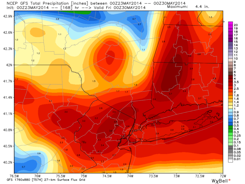
![]() by jmanley32 Fri May 23, 2014 1:02 am
by jmanley32 Fri May 23, 2014 1:02 am
jmanley32- Senior Enthusiast
- Posts : 20517
Reputation : 108
Join date : 2013-12-12
Age : 42
Location : Yonkers, NY
Re: Official Long Range Thread 3.0
![]() by jmanley32 Fri May 23, 2014 1:03 am
by jmanley32 Fri May 23, 2014 1:03 am
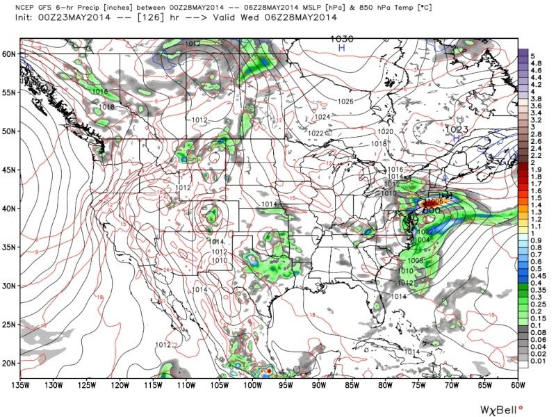
Is this the kind of thing you were talking about Frank? Or is it something else? It strengthens to 995mb but after it passes here.
jmanley32- Senior Enthusiast
- Posts : 20517
Reputation : 108
Join date : 2013-12-12
Age : 42
Location : Yonkers, NY
Re: Official Long Range Thread 3.0
![]() by Frank_Wx Fri May 30, 2014 12:22 pm
by Frank_Wx Fri May 30, 2014 12:22 pm

Looks like first ten days or so of June will feature temps around average. Amazing how the EPO is still raging negative since what seems like the end of last fall.
_________________
_______________________________________________________________________________________________________
CLICK HERE to view NJ Strong Snowstorm Classifications
Frank_Wx- Godzilla Seeker
- Posts : 21305
Reputation : 328
Join date : 2013-01-05
Age : 31
Location : Jersey City, NJ -
Re: Official Long Range Thread 3.0
![]() by Frank_Wx Tue Jun 10, 2014 12:02 pm
by Frank_Wx Tue Jun 10, 2014 12:02 pm
_________________
_______________________________________________________________________________________________________
CLICK HERE to view NJ Strong Snowstorm Classifications
Frank_Wx- Godzilla Seeker
- Posts : 21305
Reputation : 328
Join date : 2013-01-05
Age : 31
Location : Jersey City, NJ -
Re: Official Long Range Thread 3.0
![]() by jmanley32 Tue Jun 10, 2014 3:40 pm
by jmanley32 Tue Jun 10, 2014 3:40 pm
Last edited by jmanley32 on Tue Jun 10, 2014 3:43 pm; edited 1 time in total
jmanley32- Senior Enthusiast
- Posts : 20517
Reputation : 108
Join date : 2013-12-12
Age : 42
Location : Yonkers, NY
jmanley32- Senior Enthusiast
- Posts : 20517
Reputation : 108
Join date : 2013-12-12
Age : 42
Location : Yonkers, NY
Re: Official Long Range Thread 3.0
![]() by Frank_Wx Wed Jun 11, 2014 12:22 pm
by Frank_Wx Wed Jun 11, 2014 12:22 pm

The Pacific is turning into a hot tub. Looking at the Equatorial Pacific, you can see El Niño is clearly coming along. Global heat content is probably surging right now. I originally forecasted this summer to experience temps near normal, but now I wouldn't be surprised to see the season end above normal. I'm still expecting precip to be above normal, though.
_________________
_______________________________________________________________________________________________________
CLICK HERE to view NJ Strong Snowstorm Classifications
Frank_Wx- Godzilla Seeker
- Posts : 21305
Reputation : 328
Join date : 2013-01-05
Age : 31
Location : Jersey City, NJ -
Re: Official Long Range Thread 3.0
![]() by jmanley32 Wed Jun 11, 2014 1:50 pm
by jmanley32 Wed Jun 11, 2014 1:50 pm
jmanley32- Senior Enthusiast
- Posts : 20517
Reputation : 108
Join date : 2013-12-12
Age : 42
Location : Yonkers, NY
Re: Official Long Range Thread 3.0
![]() by jmanley32 Wed Jun 11, 2014 1:51 pm
by jmanley32 Wed Jun 11, 2014 1:51 pm
jmanley32- Senior Enthusiast
- Posts : 20517
Reputation : 108
Join date : 2013-12-12
Age : 42
Location : Yonkers, NY
Re: Official Long Range Thread 3.0
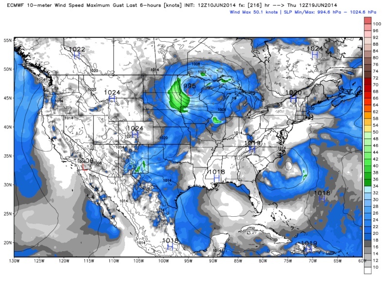
![]() by algae888 Wed Jun 11, 2014 5:50 pm
by algae888 Wed Jun 11, 2014 5:50 pm
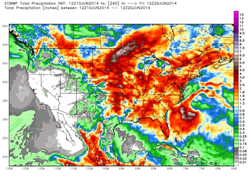
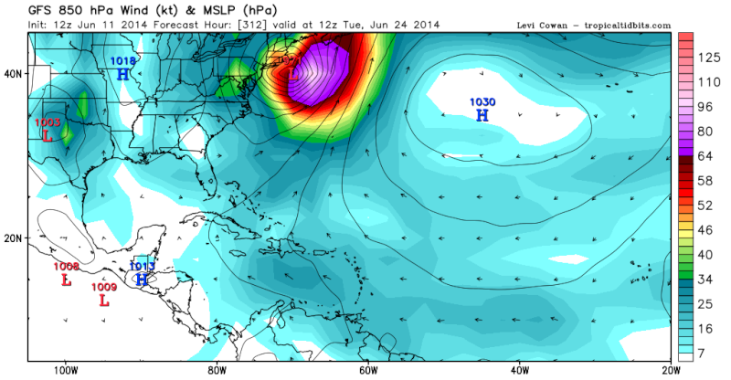
jmanley32 wrote:Since its not a active storm I figured I would post the eye bugger of a 12z GFS run, thats a bit disconcerting if by some highly numerical number the GFS was actuially right, but as stated its been doing this alot. so Entertainment purposes only. I'm trying not to be concerned but the GEFS have had a senario like this and even closer to coast for quite a few runs now, I was wondering why it took it into the GULF. Personally I believe that the GFS is not completely wrong on a storm, frank did say about hybrid storms which this looks like thats what it is. So I am keeping a eye on it nonetheless until it disappears, not losing sleep not worried but man that is some storm if it happened and just a tad further west, we do NOT need that!
jman its never going to disappear, the gfs will have a storm like this in the 10 to 15 day range the whole summer. if you see a storm on the gfs under 168hrs (one week or less) then give it some attention otherwise it's useless to post!

algae888- Advanced Forecaster
- Posts : 5311
Reputation : 46
Join date : 2013-02-05
Age : 61
Location : mt. vernon, new york
Re: Official Long Range Thread 3.0
![]() by jmanley32 Wed Jun 11, 2014 10:42 pm
by jmanley32 Wed Jun 11, 2014 10:42 pm
jmanley32- Senior Enthusiast
- Posts : 20517
Reputation : 108
Join date : 2013-12-12
Age : 42
Location : Yonkers, NY
Re: Official Long Range Thread 3.0
![]() by algae888 Wed Jun 11, 2014 11:28 pm
by algae888 Wed Jun 11, 2014 11:28 pm
jmanley32 wrote:true i should posted the first development of it at 144 hrs. Its progged to develop tuesday. which isnt too far off. If the GFS shows that all summer I will be very surprised.
jman I meant to say that in the 10 to 15 day range either the 00z,6z, 12z or18z gfs will show a tropical development somewhere in the gulf or atlantic very often. most of the time they will not develop or when they develop it will be in a totally different area. the gfs has had a tropical system since mid may almost daily and nothing has happened yet. to me the models are useless outside of 7 days. we saw enough of that this winter!
algae888- Advanced Forecaster
- Posts : 5311
Reputation : 46
Join date : 2013-02-05
Age : 61
Location : mt. vernon, new york
Re: Official Long Range Thread 3.0
![]() by algae888 Wed Jun 11, 2014 11:34 pm
by algae888 Wed Jun 11, 2014 11:34 pm
algae888- Advanced Forecaster
- Posts : 5311
Reputation : 46
Join date : 2013-02-05
Age : 61
Location : mt. vernon, new york
Re: Official Long Range Thread 3.0
![]() by algae888 Sun Jun 15, 2014 7:02 pm
by algae888 Sun Jun 15, 2014 7:02 pm
algae888- Advanced Forecaster
- Posts : 5311
Reputation : 46
Join date : 2013-02-05
Age : 61
Location : mt. vernon, new york
Re: Official Long Range Thread 3.0
![]() by Dunnzoo Sun Jun 15, 2014 7:19 pm
by Dunnzoo Sun Jun 15, 2014 7:19 pm
_________________
Janet
Snowfall winter of 2023-2024 17.5"
Snowfall winter of 2022-2023 6.0"
Snowfall winter of 2021-2022 17.6" 1" sleet 2/25/22
Snowfall winter of 2020-2021 51.1"
Snowfall winter of 2019-2020 8.5"
Snowfall winter of 2018-2019 25.1"
Snowfall winter of 2017-2018 51.9"
Snowfall winter of 2016-2017 45.6"
Snowfall winter of 2015-2016 29.5"
Snowfall winter of 2014-2015 50.55"
Snowfall winter of 2013-2014 66.5"

Dunnzoo- Senior Enthusiast - Mod

- Posts : 4892
Reputation : 68
Join date : 2013-01-11
Age : 62
Location : Westwood, NJ
Re: Official Long Range Thread 3.0
![]() by Math23x7 Sun Jun 15, 2014 10:40 pm
by Math23x7 Sun Jun 15, 2014 10:40 pm
Anybody remember that guy? I sure don't miss him xD
Anyway, I think that after this brief period of humidity midweek, it will cool back down to seasonal to below seasonal temperatures for quite some time. I wonder if we will even hit 90 by the end of June. The last time the first 90 degree day was after June 30th was 1985.
Math23x7- Wx Statistician Guru

- Posts : 2379
Reputation : 68
Join date : 2013-01-08
Page 7 of 32 • 1 ... 6, 7, 8 ... 19 ... 32 ![]()
|
|
|