
 Search
Official Long Range Thread 3.0
Page 19 of 32 •  1 ... 11 ... 18, 19, 20 ... 25 ... 32
 ![]()
Re: Official Long Range Thread 3.0
![]() by jmanley32 Mon Oct 06, 2014 12:08 pm
by jmanley32 Mon Oct 06, 2014 12:08 pm
jmanley32- Senior Enthusiast

- Posts : 20517
Join date : 2013-12-12
Re: Official Long Range Thread 3.0
![]() by devsman Mon Oct 06, 2014 1:05 pm
by devsman Mon Oct 06, 2014 1:05 pm
devsman- Pro Enthusiast

- Posts : 424
Join date : 2014-01-01
Re: Official Long Range Thread 3.0
![]() by Frank_Wx Mon Oct 06, 2014 1:29 pm
by Frank_Wx Mon Oct 06, 2014 1:29 pm
devsman wrote:The GFS is all over the place. Now it has it hitting Texas after it was being pushed out to sea this morning. Can't believe that is our go to U.S. model.
Awful. I can't wait for the upgrade. Actually, they tested the "new" GFS with a simulation of Hurricane Sandy and it showed the same track as the EURO. So definitely an improved model come 2015
_________________
_______________________________________________________________________________________________________
CLICK HERE to view NJ Strong Snowstorm Classifications

Frank_Wx- Godzilla Seeker

- Posts : 21305
Reputation : 328
Join date : 2013-01-05
Age : 31
Location : Jersey City, NJ -

Re: Official Long Range Thread 3.0
![]() by jmanley32 Mon Oct 06, 2014 2:12 pm
by jmanley32 Mon Oct 06, 2014 2:12 pm

jmanley32- Senior Enthusiast
- Posts : 20517
Reputation : 108
Join date : 2013-12-12
Age : 42
Location : Yonkers, NY
Re: Official Long Range Thread 3.0
![]() by jmanley32 Mon Oct 06, 2014 2:28 pm
by jmanley32 Mon Oct 06, 2014 2:28 pm
jmanley32- Senior Enthusiast
- Posts : 20517
Reputation : 108
Join date : 2013-12-12
Age : 42
Location : Yonkers, NY
Re: Official Long Range Thread 3.0
![]() by jmanley32 Mon Oct 06, 2014 3:32 pm
by jmanley32 Mon Oct 06, 2014 3:32 pm
jmanley32- Senior Enthusiast
- Posts : 20517
Reputation : 108
Join date : 2013-12-12
Age : 42
Location : Yonkers, NY
Re: Official Long Range Thread 3.0
![]() by jmanley32 Mon Oct 06, 2014 3:54 pm
by jmanley32 Mon Oct 06, 2014 3:54 pm
jmanley32- Senior Enthusiast
- Posts : 20517
Reputation : 108
Join date : 2013-12-12
Age : 42
Location : Yonkers, NY
Re: Official Long Range Thread 3.0
![]() by SNOW MAN Tue Oct 07, 2014 6:04 am
by SNOW MAN Tue Oct 07, 2014 6:04 am

SNOW MAN- Senior Enthusiast
- Posts : 1361
Reputation : 25
Join date : 2013-01-13
Age : 64
Location : Marshalls Creek Pa.
Re: Official Long Range Thread 3.0
![]() by jmanley32 Tue Oct 07, 2014 7:29 am
by jmanley32 Tue Oct 07, 2014 7:29 am
jmanley32- Senior Enthusiast
- Posts : 20517
Reputation : 108
Join date : 2013-12-12
Age : 42
Location : Yonkers, NY
Re: Official Long Range Thread 3.0
![]() by jmanley32 Tue Oct 07, 2014 7:33 am
by jmanley32 Tue Oct 07, 2014 7:33 am
jmanley32- Senior Enthusiast
- Posts : 20517
Reputation : 108
Join date : 2013-12-12
Age : 42
Location : Yonkers, NY
Re: Official Long Range Thread 3.0
![]() by jmanley32 Tue Oct 07, 2014 9:09 am
by jmanley32 Tue Oct 07, 2014 9:09 am
jmanley32- Senior Enthusiast
- Posts : 20517
Reputation : 108
Join date : 2013-12-12
Age : 42
Location : Yonkers, NY
Re: Official Long Range Thread 3.0
![]() by amugs Tue Oct 07, 2014 9:12 am
by amugs Tue Oct 07, 2014 9:12 am
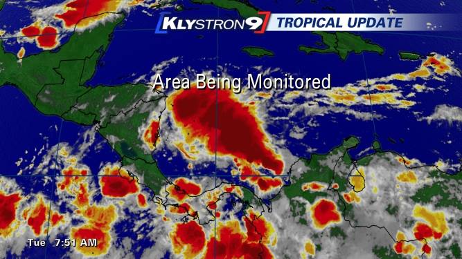
SNOW MAN wrote:I'm a little concerned about this possible storm coming up next week. The reason being, I really go all out with my Halloween decorations and when I heard about Sandy coming I was a little reluctant to take it all down and put it away before she hit. Boy was I glad I listened to the forecast from the people on this board and put everything away. I'm just wondering is this possible storm going to have high winds with tons of rain ? I know it probably won't be as bad as Sandy (hopefully), but I don't want my decorations being blown away and wrecked. I would appreciate any thoughts on this event. Thanks.
Snow,
to early to call on this one as are most storms this far out we have to wait until the end of this week to see where things are at to get a better gauge of this - not what you wanted to hear I am sure but the patterns seems to be active as we move towards the middle of the month time frame.
_________________
Mugs
AKA:King: Snow Weenie
Self Proclaimed
WINTER 2014-15 : 55.12" +.02 for 6 coatings (avg. 35")
WINTER 2015-16 Total - 29.8" (Avg 35")
WINTER 2016-17 : 39.5" so far

amugs- Advanced Forecaster - Mod

- Posts : 15093
Reputation : 213
Join date : 2013-01-07
Age : 54
Location : Hillsdale,NJ
Re: Official Long Range Thread 3.0
![]() by Frank_Wx Tue Oct 07, 2014 9:33 am
by Frank_Wx Tue Oct 07, 2014 9:33 am
_________________
_______________________________________________________________________________________________________
CLICK HERE to view NJ Strong Snowstorm Classifications
Frank_Wx- Godzilla Seeker
- Posts : 21305
Reputation : 328
Join date : 2013-01-05
Age : 31
Location : Jersey City, NJ -
Re: Official Long Range Thread 3.0
![]() by sroc4 Tue Oct 07, 2014 12:09 pm
by sroc4 Tue Oct 07, 2014 12:09 pm
When you read the tea leaves here one would see that the fact that Frank hasn't mentioned anything about this means it prob is whole lot of nothing. HOWEVER, the fact that Frank has also NOT mentioned anything about this could ALSO mean that there is some potential for something to develop but since the models have such drastically different upper level differences that there is no way one can lean in any direction this far out.
If you look at the GFS Ensembles as well as the Euro Ensembles there is also large differences in "weather" (see what I did there) or not LP develops off the Yukatan coast or not in the 5-7 day and if its drawn north by the impending trough mentioned above. There are also differences seen in development or non development, and how close, or how far from the SE coast LP in the SW Atlantic develops if it develops at all. Its all going to play a role.
In my experience when you have such huge differences in both the operational models as well as the ensembles (Euro vs GFS) a pattern change on a fairly broad scale is trying to happen and models are having a hard time locking onto what that is because there are so many large scale upper level features that need to evolve.
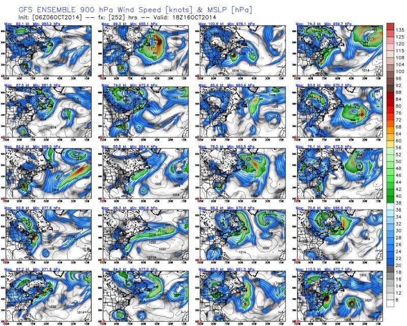
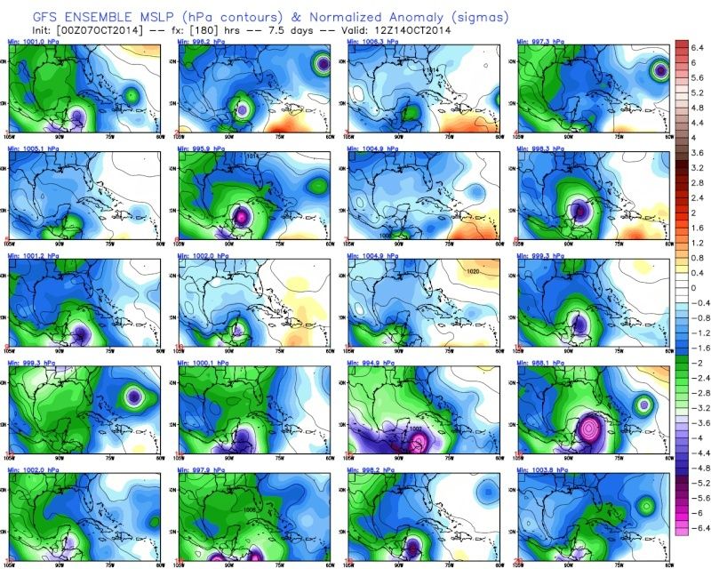
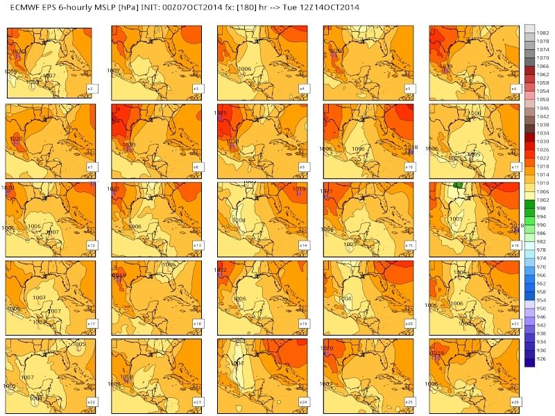
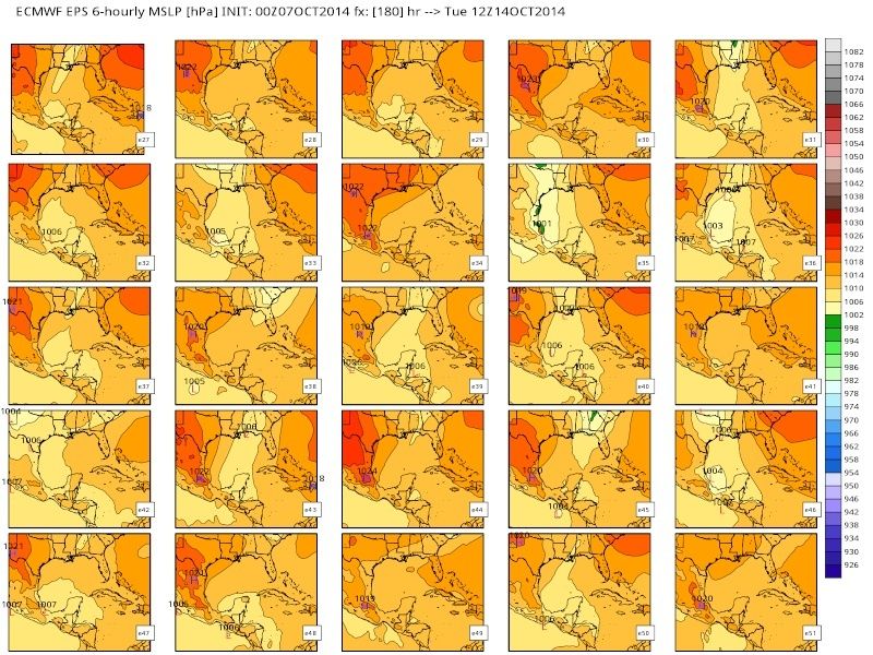
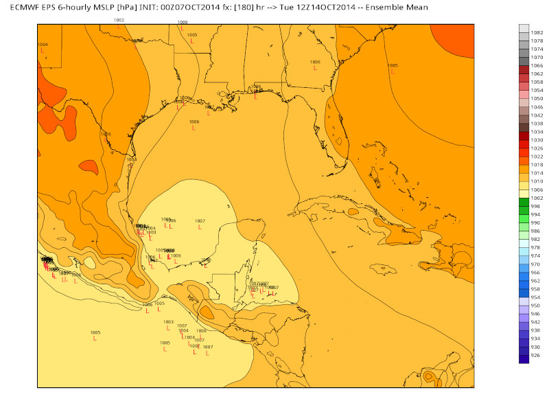
My point here is we wait and watch. Watching individual operational model runs is great and helpful, but over the next few days look to the ensembles. See if one model starts to trend towards the other. Look at the number of individual members showing a particular soln, and we see if a trend where more mmebers within an individual model move towards a specific soln. Just look at the differences between the GFS Ensemble members and Euro members. This is all for th time frame of Tuesday 14th 12z
GFS:
 " />
" />Euro Members 2-50
 " />
" /> " />
" />[img]
 [/img]
If you believe the GFS Ens then about 2/3rds of the members have a system develop of the SE Yukatan. If you believe the Euro Ens then maybe 6 of 50 have a LP develop in that area. The Euro members have some that develop a LP center over the BOC instead but less than half total have a LP develop in this general area at all.
_________________
"In weather and in life, there's no winning and losing; there's only winning and learning."
WINTER 2012/2013 TOTALS 43.65"WINTER 2017/2018 TOTALS 62.85" WINTER 2022/2023 TOTALS 4.9"
WINTER 2013/2014 TOTALS 64.85"WINTER 2018/2019 TOTALS 14.25" WINTER 2023/2024 TOTALS 13.1"
WINTER 2014/2015 TOTALS 71.20"WINTER 2019/2020 TOTALS 6.35"
WINTER 2015/2016 TOTALS 35.00"WINTER 2020/2021 TOTALS 37.75"
WINTER 2016/2017 TOTALS 42.25"WINTER 2021/2022 TOTALS 31.65"

sroc4- Admin
- Posts : 8331
Reputation : 301
Join date : 2013-01-07
Location : Wading River, LI
Re: Official Long Range Thread 3.0
![]() by algae888 Tue Oct 07, 2014 3:17 pm
by algae888 Tue Oct 07, 2014 3:17 pm

algae888- Advanced Forecaster

- Posts : 5311
Reputation : 46
Join date : 2013-02-05
Age : 61
Location : mt. vernon, new york
Re: Official Long Range Thread 3.0
![]() by algae888 Tue Oct 07, 2014 3:22 pm
by algae888 Tue Oct 07, 2014 3:22 pm
algae888- Advanced Forecaster
- Posts : 5311
Reputation : 46
Join date : 2013-02-05
Age : 61
Location : mt. vernon, new york
Re: Official Long Range Thread 3.0
![]() by Frank_Wx Tue Oct 07, 2014 3:31 pm
by Frank_Wx Tue Oct 07, 2014 3:31 pm
algae888 wrote:stevie d believes el-nino will not be a driving factor in the 500mb pattern for this winter. says models have done poor job of forecasting it. he thinks sst in northern pac and stratospheric warming will be key factors and if el-nino develops it will enhance the pattern. so does this mean we can expect a warmer and less active winter?
I have been monitoring the SST's in the ENSO region on a weekly basis. They are not making the progress I expected them too, and as of now, the diagnostic an statistical models are busting badly. ENSO region 3.4 as of last week was at +0.3, though region 1+2 is up to +1.0. However, region 3.4 is most important. I stll think it is too early. I want the rest of October and 1st half of November to finish out before concluding El Nino will not be a driving factor this winter.
_________________
_______________________________________________________________________________________________________
CLICK HERE to view NJ Strong Snowstorm Classifications
Frank_Wx- Godzilla Seeker
- Posts : 21305
Reputation : 328
Join date : 2013-01-05
Age : 31
Location : Jersey City, NJ -
Re: Official Long Range Thread 3.0
![]() by Frank_Wx Tue Oct 07, 2014 3:36 pm
by Frank_Wx Tue Oct 07, 2014 3:36 pm
_________________
_______________________________________________________________________________________________________
CLICK HERE to view NJ Strong Snowstorm Classifications
Frank_Wx- Godzilla Seeker
- Posts : 21305
Reputation : 328
Join date : 2013-01-05
Age : 31
Location : Jersey City, NJ -
Re: Official Long Range Thread 3.0
![]() by jmanley32 Tue Oct 07, 2014 4:03 pm
by jmanley32 Tue Oct 07, 2014 4:03 pm
jmanley32- Senior Enthusiast
- Posts : 20517
Reputation : 108
Join date : 2013-12-12
Age : 42
Location : Yonkers, NY
Re: Official Long Range Thread 3.0
![]() by HectorO Tue Oct 07, 2014 5:54 pm
by HectorO Tue Oct 07, 2014 5:54 pm

HectorO- Pro Enthusiast
- Posts : 959
Reputation : 27
Join date : 2013-01-11
Re: Official Long Range Thread 3.0
![]() by HectorO Tue Oct 07, 2014 5:58 pm
by HectorO Tue Oct 07, 2014 5:58 pm
Frank_Wx wrote:Getting back to the warmth next week, I expressed concern in this when I did an October outlook in the other thread. With storm phasing and cutting off in the Midwest, this is going to allow the southeast ridge to amplify and bring our temp. departures 15-20 degrees above normal, at times.
I'll wait and see on that I think 20 above normal is a bit much. That would mean 80 for some people and as of right now I'm not seeing anything like that. I'm still seeing 60s next week. How late are you talking?
HectorO- Pro Enthusiast
- Posts : 959
Reputation : 27
Join date : 2013-01-11
Re: Official Long Range Thread 3.0
![]() by jmanley32 Tue Oct 07, 2014 7:45 pm
by jmanley32 Tue Oct 07, 2014 7:45 pm
jmanley32- Senior Enthusiast
- Posts : 20517
Reputation : 108
Join date : 2013-12-12
Age : 42
Location : Yonkers, NY
Re: Official Long Range Thread 3.0
![]() by jmanley32 Tue Oct 07, 2014 7:53 pm
by jmanley32 Tue Oct 07, 2014 7:53 pm
jmanley32- Senior Enthusiast
- Posts : 20517
Reputation : 108
Join date : 2013-12-12
Age : 42
Location : Yonkers, NY
Re: Official Long Range Thread 3.0
![]() by Quietace Tue Oct 07, 2014 8:24 pm
by Quietace Tue Oct 07, 2014 8:24 pm
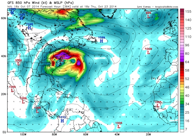
384 hours out. Fantasy storm and should be left there like so many others.jmanley32 wrote:OK, OMG this is laughable at the least with its terrible track record but OMG if this happened its Sandy part 2 (and only a week difference), look at the size of that thing, I think the GFS is high on angel dust!

Quietace- Meteorologist - Mod

- Posts : 3687
Reputation : 33
Join date : 2013-01-07
Age : 27
Location : Point Pleasant, NJ
Re: Official Long Range Thread 3.0
![]() by Frank_Wx Tue Oct 07, 2014 8:32 pm
by Frank_Wx Tue Oct 07, 2014 8:32 pm
HectorO wrote:Frank_Wx wrote:Getting back to the warmth next week, I expressed concern in this when I did an October outlook in the other thread. With storm phasing and cutting off in the Midwest, this is going to allow the southeast ridge to amplify and bring our temp. departures 15-20 degrees above normal, at times.
I'll wait and see on that I think 20 above normal is a bit much. That would mean 80 for some people and as of right now I'm not seeing anything like that. I'm still seeing 60s next week. How late are you talking?
It depends on which models 500 mb pattern depiction is correct. GFS is progressive and keeps temps average, while the EURO is cutting storms off and raising heights over our area near 588dm.
_________________
_______________________________________________________________________________________________________
CLICK HERE to view NJ Strong Snowstorm Classifications
Frank_Wx- Godzilla Seeker
- Posts : 21305
Reputation : 328
Join date : 2013-01-05
Age : 31
Location : Jersey City, NJ -
Re: Official Long Range Thread 3.0
![]() by jmanley32 Tue Oct 07, 2014 9:06 pm
by jmanley32 Tue Oct 07, 2014 9:06 pm
jmanley32- Senior Enthusiast
- Posts : 20517
Reputation : 108
Join date : 2013-12-12
Age : 42
Location : Yonkers, NY
Re: Official Long Range Thread 3.0
![]() by HectorO Tue Oct 07, 2014 9:47 pm
by HectorO Tue Oct 07, 2014 9:47 pm
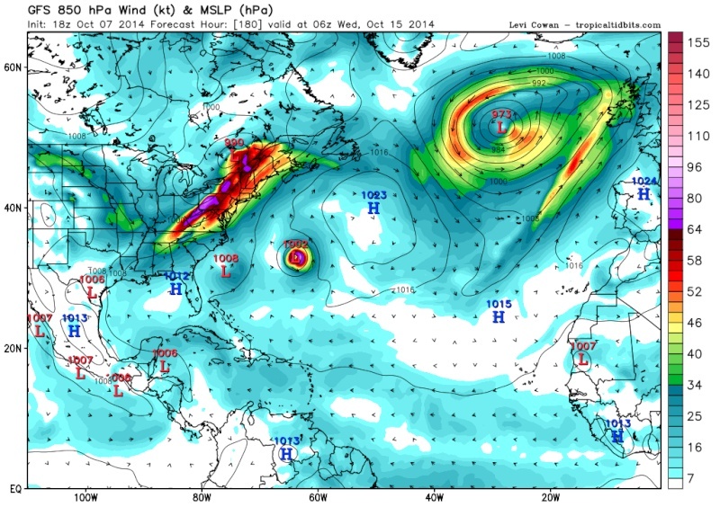
jmanley32 wrote:I am aware Quietace, i do not think a Sandy 2 would be anybodys fantasy. Anythoughts on the second post which is much closer in time?
I agree, but there are people with sick fantasies lol.
HectorO- Pro Enthusiast
- Posts : 959
Reputation : 27
Join date : 2013-01-11
Page 19 of 32 • 1 ... 11 ... 18, 19, 20 ... 25 ... 32 ![]()
|
|
|