
 Search
Official Long Range Thread 3.0
Page 8 of 32 •  1 ... 5 ... 7, 8, 9 ... 20 ... 32
 ![]()
Re: Official Long Range Thread 3.0
![]() by Dunnzoo Sun Jun 15, 2014 7:19 pm
by Dunnzoo Sun Jun 15, 2014 7:19 pm
Dunnzoo- Senior Enthusiast - Mod

- Posts : 4891
Join date : 2013-01-11
Re: Official Long Range Thread 3.0
![]() by Math23x7 Sun Jun 15, 2014 10:40 pm
by Math23x7 Sun Jun 15, 2014 10:40 pm
Anybody remember that guy? I sure don't miss him xD
Anyway, I think that after this brief period of humidity midweek, it will cool back down to seasonal to below seasonal temperatures for quite some time. I wonder if we will even hit 90 by the end of June. The last time the first 90 degree day was after June 30th was 1985.
Math23x7- Wx Statistician Guru

- Posts : 2379
Join date : 2013-01-08
Re: Official Long Range Thread 3.0
![]() by Frank_Wx Mon Jun 16, 2014 9:43 am
by Frank_Wx Mon Jun 16, 2014 9:43 am
Math23x7 wrote:"nO cOLd Or SnoW thROugh jUNE 30tH"
Anybody remember that guy? I sure don't miss him xD
Anyway, I think that after this brief period of humidity midweek, it will cool back down to seasonal to below seasonal temperatures for quite some time. I wonder if we will even hit 90 by the end of June. The last time the first 90 degree day was after June 30th was 1985.
I would ban it immediately if it ever came here
_________________
_______________________________________________________________________________________________________
CLICK HERE to view NJ Strong Snowstorm Classifications

Frank_Wx- Godzilla Seeker

- Posts : 21305
Reputation : 328
Join date : 2013-01-05
Age : 31
Location : Jersey City, NJ -

Re: Official Long Range Thread 3.0
![]() by Frank_Wx Thu Jun 19, 2014 7:31 am
by Frank_Wx Thu Jun 19, 2014 7:31 am
_________________
_______________________________________________________________________________________________________
CLICK HERE to view NJ Strong Snowstorm Classifications
Frank_Wx- Godzilla Seeker
- Posts : 21305
Reputation : 328
Join date : 2013-01-05
Age : 31
Location : Jersey City, NJ -
Re: Official Long Range Thread 3.0
![]() by nutleyblizzard Fri Jun 20, 2014 7:15 am
by nutleyblizzard Fri Jun 20, 2014 7:15 am

nutleyblizzard- Senior Enthusiast

- Posts : 1952
Reputation : 41
Join date : 2014-01-30
Age : 58
Location : Nutley, new jersey
Re: Official Long Range Thread 3.0
![]() by Dunnzoo Fri Jun 20, 2014 7:56 am
by Dunnzoo Fri Jun 20, 2014 7:56 am
nutleyblizzard wrote:This board is dead. No severe storms, nothing to track in the tropics. Don't despair… only 164 days till meteorological winter kicks in!
Thankfully it has been quiet, good for all the graduations...I have been watching the weather in the midwest, all those tornadoes and the twin twisters, amazing stuff..will be watching the weather for the west coast soon, heading out there for vacation on July 4th.....
spectacular day today...love it!
_________________
Janet
Snowfall winter of 2023-2024 17.5"
Snowfall winter of 2022-2023 6.0"
Snowfall winter of 2021-2022 17.6" 1" sleet 2/25/22
Snowfall winter of 2020-2021 51.1"
Snowfall winter of 2019-2020 8.5"
Snowfall winter of 2018-2019 25.1"
Snowfall winter of 2017-2018 51.9"
Snowfall winter of 2016-2017 45.6"
Snowfall winter of 2015-2016 29.5"
Snowfall winter of 2014-2015 50.55"
Snowfall winter of 2013-2014 66.5"

Dunnzoo- Senior Enthusiast - Mod
- Posts : 4891
Reputation : 68
Join date : 2013-01-11
Age : 62
Location : Westwood, NJ
Re: Official Long Range Thread 3.0
![]() by Snow88 Sun Jun 22, 2014 10:10 am
by Snow88 Sun Jun 22, 2014 10:10 am

Snow88- Senior Enthusiast
- Posts : 2193
Reputation : 4
Join date : 2013-01-09
Age : 35
Location : Brooklyn, NY
Re: Official Long Range Thread 3.0
![]() by Dunnzoo Sun Jun 22, 2014 10:43 am
by Dunnzoo Sun Jun 22, 2014 10:43 am
_________________
Janet
Snowfall winter of 2023-2024 17.5"
Snowfall winter of 2022-2023 6.0"
Snowfall winter of 2021-2022 17.6" 1" sleet 2/25/22
Snowfall winter of 2020-2021 51.1"
Snowfall winter of 2019-2020 8.5"
Snowfall winter of 2018-2019 25.1"
Snowfall winter of 2017-2018 51.9"
Snowfall winter of 2016-2017 45.6"
Snowfall winter of 2015-2016 29.5"
Snowfall winter of 2014-2015 50.55"
Snowfall winter of 2013-2014 66.5"
Dunnzoo- Senior Enthusiast - Mod
- Posts : 4891
Reputation : 68
Join date : 2013-01-11
Age : 62
Location : Westwood, NJ
Re: Official Long Range Thread 3.0
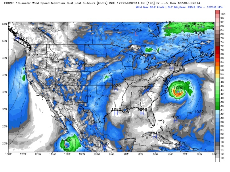
![]() by Frank_Wx Sun Jun 22, 2014 5:33 pm
by Frank_Wx Sun Jun 22, 2014 5:33 pm
GFS:

GGEM:

Positive height potential for the entire eastern U.S. and eastern Canada with interlocking ridges.

_________________
_______________________________________________________________________________________________________
CLICK HERE to view NJ Strong Snowstorm Classifications
Frank_Wx- Godzilla Seeker
- Posts : 21305
Reputation : 328
Join date : 2013-01-05
Age : 31
Location : Jersey City, NJ -
Re: Official Long Range Thread 3.0
![]() by jmanley32 Sun Jun 22, 2014 8:31 pm
by jmanley32 Sun Jun 22, 2014 8:31 pm

jmanley32- Senior Enthusiast
- Posts : 20516
Reputation : 108
Join date : 2013-12-12
Age : 42
Location : Yonkers, NY
Re: Official Long Range Thread 3.0
![]() by jmanley32 Sun Jun 22, 2014 8:34 pm
by jmanley32 Sun Jun 22, 2014 8:34 pm

jmanley32- Senior Enthusiast
- Posts : 20516
Reputation : 108
Join date : 2013-12-12
Age : 42
Location : Yonkers, NY
Re: Official Long Range Thread 3.0
![]() by algae888 Mon Jun 23, 2014 9:27 pm
by algae888 Mon Jun 23, 2014 9:27 pm
jmanley32 wrote:CMC also has something quite similar, cold core for being so far north? Seems to originate from south though.
.from NWs disco..NOTING THE ECMWF CONTINUES TO WANT
TO DEVELOP A CLOSED COLD-CORE LOW OFF THE EAST COAST EARLY NEXT WEEK. euro also wants to develop a cold-core low. nothing remotely tropical with this system. and btw since when do we give any credibility to the farmer's almanac? they try to predict weather a year in advance which besides being nearly impossible is grossly irresponsible.

algae888- Advanced Forecaster

- Posts : 5311
Reputation : 46
Join date : 2013-02-05
Age : 61
Location : mt. vernon, new york
Re: Official Long Range Thread 3.0
![]() by jmanley32 Mon Jun 23, 2014 10:50 pm
by jmanley32 Mon Jun 23, 2014 10:50 pm
jmanley32- Senior Enthusiast
- Posts : 20516
Reputation : 108
Join date : 2013-12-12
Age : 42
Location : Yonkers, NY
Re: Official Long Range Thread 3.0
![]() by Frank_Wx Fri Jun 27, 2014 9:42 am
by Frank_Wx Fri Jun 27, 2014 9:42 am
The heat is no longer looking like a story next week. Instead, temperatures mainly around average to possibly below average by the 4th of July as a low level, broad trough works it's way into the area.

We'll see if these models flip again back to the heat idea, but looking less likely.
_________________
_______________________________________________________________________________________________________
CLICK HERE to view NJ Strong Snowstorm Classifications
Frank_Wx- Godzilla Seeker
- Posts : 21305
Reputation : 328
Join date : 2013-01-05
Age : 31
Location : Jersey City, NJ -
Re: Official Long Range Thread 3.0
![]() by Frank_Wx Sat Jun 28, 2014 10:16 am
by Frank_Wx Sat Jun 28, 2014 10:16 am
The 4th of July looks sunny right now- and not as warm- with temps possibly in the low 80's.
_________________
_______________________________________________________________________________________________________
CLICK HERE to view NJ Strong Snowstorm Classifications
Frank_Wx- Godzilla Seeker
- Posts : 21305
Reputation : 328
Join date : 2013-01-05
Age : 31
Location : Jersey City, NJ -
Re: Official Long Range Thread 3.0
![]() by Frank_Wx Tue Jul 01, 2014 8:26 pm
by Frank_Wx Tue Jul 01, 2014 8:26 pm
July may actually feature much of the same. I'm sure we may see our first heat wave, but if we do, it is not coming until mid to end of July. The first few days of this month will feature some rainy conditions along with a broadened trough. Then we kind of go into a zonal pattern beginning Sunday and that looks to continue into the foreseeable future. You can see that below from the Day 10 maps.

That's also confirmed by the GGEM (as well as the GFS). It is keeping the bulk of the ridging in the western US and the east in a mainly up and down pattern. Some days above normal, others below, which results in a mainly average departure from normal similar to June.


_________________
_______________________________________________________________________________________________________
CLICK HERE to view NJ Strong Snowstorm Classifications
Frank_Wx- Godzilla Seeker
- Posts : 21305
Reputation : 328
Join date : 2013-01-05
Age : 31
Location : Jersey City, NJ -
Re: Official Long Range Thread 3.0
![]() by Frank_Wx Tue Jul 01, 2014 8:32 pm
by Frank_Wx Tue Jul 01, 2014 8:32 pm
_________________
_______________________________________________________________________________________________________
CLICK HERE to view NJ Strong Snowstorm Classifications
Frank_Wx- Godzilla Seeker
- Posts : 21305
Reputation : 328
Join date : 2013-01-05
Age : 31
Location : Jersey City, NJ -
Re: Official Long Range Thread 3.0
![]() by devsman Thu Jul 03, 2014 8:38 pm
by devsman Thu Jul 03, 2014 8:38 pm
Frank_Wx wrote:And for those curious, EL Niño is still progressing. There's a good chance the end of this summer and the fall will feature El Niño conditions.
Meaning what? I'm not sure what happens with an el Nino.

devsman- Pro Enthusiast

- Posts : 424
Reputation : 4
Join date : 2014-01-01
Age : 48
Location : merrick, ny (south shore of Long Island)
Re: Official Long Range Thread 3.0
![]() by Frank_Wx Mon Jul 07, 2014 12:44 pm
by Frank_Wx Mon Jul 07, 2014 12:44 pm

With a super typhoon expected to curve the western Pacific, this is likely to lead to cooler than normal conditions in the eastern US by mid month. July is likely to finish anywhere from normal to perhaps slightly below normal.
_________________
_______________________________________________________________________________________________________
CLICK HERE to view NJ Strong Snowstorm Classifications
Frank_Wx- Godzilla Seeker
- Posts : 21305
Reputation : 328
Join date : 2013-01-05
Age : 31
Location : Jersey City, NJ -
Re: Official Long Range Thread 3.0
![]() by Frank_Wx Mon Jul 07, 2014 12:46 pm
by Frank_Wx Mon Jul 07, 2014 12:46 pm
devsman wrote:Frank_Wx wrote:And for those curious, EL Niño is still progressing. There's a good chance the end of this summer and the fall will feature El Niño conditions.
Meaning what? I'm not sure what happens with an el Nino.
Temperatures around normal to slightly below with above average precipitation.
_________________
_______________________________________________________________________________________________________
CLICK HERE to view NJ Strong Snowstorm Classifications
Frank_Wx- Godzilla Seeker
- Posts : 21305
Reputation : 328
Join date : 2013-01-05
Age : 31
Location : Jersey City, NJ -
Re: Official Long Range Thread 3.0
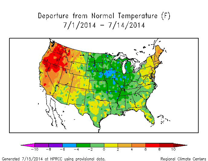
![]() by Frank_Wx Tue Jul 15, 2014 11:14 am
by Frank_Wx Tue Jul 15, 2014 11:14 am
Earlier this month I gave a July outlook for the first half. Reviewing that, it went as expected with the core of the above normal temp departures in the west U.S., colder then normal in the central U.S., and average to slightly above in the northeast U.S.
Our area seems to be under a general weakness, whereas we're constantly experiencing varying degrees of temp departures each week.
According to the GEFS, this type of pattern is likely to continue for the second half of the month. Core of the heat remains in the west, and we are mainly up and down. I do think precipitation will be on the increase though. More of a steadier type of rain, not these convective like days.
_________________
_______________________________________________________________________________________________________
CLICK HERE to view NJ Strong Snowstorm Classifications
Frank_Wx- Godzilla Seeker
- Posts : 21305
Reputation : 328
Join date : 2013-01-05
Age : 31
Location : Jersey City, NJ -
Re: Official Long Range Thread 3.0
![]() by algae888 Wed Jul 16, 2014 9:30 pm
by algae888 Wed Jul 16, 2014 9:30 pm
.HYDROLOGY...
NO HYDROLOGIC ISSUES ARE EXPECTED THROUGH AT LEAST EARLY NEXT
WEEK.
looking like we will be going into a nice stretch of dry weather. today's 18z gfs has no measurable precip through 384hrs. nice!!
algae888- Advanced Forecaster
- Posts : 5311
Reputation : 46
Join date : 2013-02-05
Age : 61
Location : mt. vernon, new york
Re: Official Long Range Thread 3.0
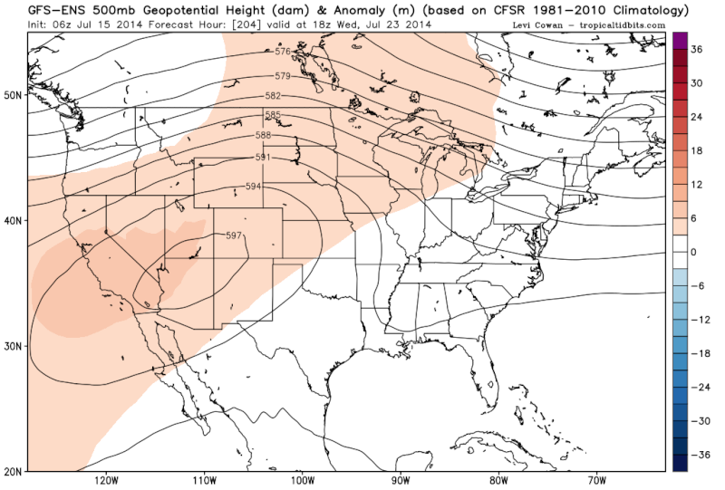
![]() by Frank_Wx Tue Jul 22, 2014 9:05 am
by Frank_Wx Tue Jul 22, 2014 9:05 am

Rex Block showing up on the models for next week. This looks legit and will likely protect us from any tropical storms as well.
_________________
_______________________________________________________________________________________________________
CLICK HERE to view NJ Strong Snowstorm Classifications
Frank_Wx- Godzilla Seeker
- Posts : 21305
Reputation : 328
Join date : 2013-01-05
Age : 31
Location : Jersey City, NJ -
Re: Official Long Range Thread 3.0
![]() by algae888 Wed Jul 23, 2014 1:25 am
by algae888 Wed Jul 23, 2014 1:25 am
algae888- Advanced Forecaster
- Posts : 5311
Reputation : 46
Join date : 2013-02-05
Age : 61
Location : mt. vernon, new york
Re: Official Long Range Thread 3.0
![]() by Frank_Wx Sun Jul 27, 2014 12:42 am
by Frank_Wx Sun Jul 27, 2014 12:42 am
Frank_Wx wrote:
Rex Block showing up on the models for next week. This looks legit and will likely protect us from any tropical storms as well.
Fast forward a few days later, and guess what, nothing has changed. Next week looks mighty cool with an elongated trough settling over the area due to all the positive heights anomalies over Canada

_________________
_______________________________________________________________________________________________________
CLICK HERE to view NJ Strong Snowstorm Classifications
Frank_Wx- Godzilla Seeker
- Posts : 21305
Reputation : 328
Join date : 2013-01-05
Age : 31
Location : Jersey City, NJ -
Re: Official Long Range Thread 3.0
![]() by nutleyblizzard Sun Jul 27, 2014 8:11 am
by nutleyblizzard Sun Jul 27, 2014 8:11 am
nutleyblizzard- Senior Enthusiast
- Posts : 1952
Reputation : 41
Join date : 2014-01-30
Age : 58
Location : Nutley, new jersey
Re: Official Long Range Thread 3.0
![]() by amugs Sun Jul 27, 2014 9:38 am
by amugs Sun Jul 27, 2014 9:38 am
From your post to God's ears as they say! Nuts this would be epic if this were to occur in late Jan to mid feb timeframe that is the snowiest period of our winter here, historically speaking.nutleyblizzard wrote:
Also, looks to be a wet period as well the first week or two in Aug we look to be near normal temps doing wonders for my electric bill not using the a/c!!
_________________
Mugs
AKA:King: Snow Weenie
Self Proclaimed
WINTER 2014-15 : 55.12" +.02 for 6 coatings (avg. 35")
WINTER 2015-16 Total - 29.8" (Avg 35")
WINTER 2016-17 : 39.5" so far

amugs- Advanced Forecaster - Mod
- Posts : 15093
Reputation : 213
Join date : 2013-01-07
Age : 54
Location : Hillsdale,NJ
Page 8 of 32 • 1 ... 5 ... 7, 8, 9 ... 20 ... 32 ![]()
|
|
|