
 Search
Official Long Range Thread 3.0
Page 13 of 32 •  1 ... 8 ... 12, 13, 14 ... 22 ... 32
 ![]()
Re: Official Long Range Thread 3.0
![]() by algae888 Sun Sep 14, 2014 8:38 am
by algae888 Sun Sep 14, 2014 8:38 am
algae888- Advanced Forecaster

- Posts : 5311
Join date : 2013-02-05
Re: Official Long Range Thread 3.0
![]() by algae888 Sun Sep 14, 2014 8:52 am
by algae888 Sun Sep 14, 2014 8:52 am
algae888- Advanced Forecaster
- Posts : 5311
Join date : 2013-02-05
Re: Official Long Range Thread 3.0
![]() by amugs Sun Sep 14, 2014 2:39 pm
by amugs Sun Sep 14, 2014 2:39 pm
Radz wrote:Wow the CFS! Well, with temps dropping i'm also getting ready- i came on here with my snow weenie hat on to post this link http://boston.cbslocal.com/2014/09/11/the-92-93-connection-winter-preview/ Good read!
Great read and interesting parallels - just like history - it repeats itself! From hi slips to Mother Nature's ears that the +PNA sets up over the NW CONUS and we get a nice dip in the jet - get the - AO and NAO - open up the STJ and bam - snow weenie's delight!
I know, I know but one can only dream!
_________________
Mugs
AKA:King: Snow Weenie
Self Proclaimed
WINTER 2014-15 : 55.12" +.02 for 6 coatings (avg. 35")
WINTER 2015-16 Total - 29.8" (Avg 35")
WINTER 2016-17 : 39.5" so far

amugs- Advanced Forecaster - Mod

- Posts : 15093
Reputation : 213
Join date : 2013-01-07
Age : 54
Location : Hillsdale,NJ
Re: Official Long Range Thread 3.0
![]() by jmanley32 Mon Sep 15, 2014 10:49 am
by jmanley32 Mon Sep 15, 2014 10:49 am

jmanley32- Senior Enthusiast

- Posts : 20516
Reputation : 108
Join date : 2013-12-12
Age : 42
Location : Yonkers, NY
Re: Official Long Range Thread 3.0
![]() by docstox12 Mon Sep 15, 2014 12:56 pm
by docstox12 Mon Sep 15, 2014 12:56 pm
My Mom hits 94 in a few weeks, and thank God, she is doing great even after recovering from a broken wrist over the summer.
My thoughts on Long Range....way too early to tell anything right now.See what Frank and Doc and the other weather techies come up with reading the tellies in late November.As they used to say...."Stay tuned...."

docstox12- Wx Statistician Guru

- Posts : 8504
Reputation : 222
Join date : 2013-01-07
Age : 73
Location : Monroe NY
Re: Official Long Range Thread 3.0
![]() by amugs Mon Sep 15, 2014 2:23 pm
by amugs Mon Sep 15, 2014 2:23 pm
jmanley32 wrote:amugs giggity! You made my day, I can only hope this winter season brings us some brutes, blizzards and high winds (no jinx I knocked on wood)! It better not treat us to bogus models like the tropics have been doing, does that change with the season? Or can we expect similar scenes from the CMC etc. Thanks for that and if in case you didnt see tropics section my gramps passed at 93 years old last night. Sad but was expected as he had DNR and was in a morphine induced sleep state so he could pass peacefully.
Jman,
My sincere sympathies to you and your family and I am sorry to hear this. He is in a better place at this time and will ALWAYS be with you and the ones he loved. I truly believe this and it will hopefully bring you comfort in theses next days and weeks ahead. Keep his memory with you always by sharing stories, pictures and the like and may he bring us from the heaven's above a kick ass winter!!!
Mugs
_________________
Mugs
AKA:King: Snow Weenie
Self Proclaimed
WINTER 2014-15 : 55.12" +.02 for 6 coatings (avg. 35")
WINTER 2015-16 Total - 29.8" (Avg 35")
WINTER 2016-17 : 39.5" so far
amugs- Advanced Forecaster - Mod
- Posts : 15093
Reputation : 213
Join date : 2013-01-07
Age : 54
Location : Hillsdale,NJ
Re: Official Long Range Thread 3.0
![]() by Frank_Wx Mon Sep 15, 2014 2:36 pm
by Frank_Wx Mon Sep 15, 2014 2:36 pm
jmanley32 wrote:amugs giggity! You made my day, I can only hope this winter season brings us some brutes, blizzards and high winds (no jinx I knocked on wood)! It better not treat us to bogus models like the tropics have been doing, does that change with the season? Or can we expect similar scenes from the CMC etc. Thanks for that and if in case you didnt see tropics section my gramps passed at 93 years old last night. Sad but was expected as he had DNR and was in a morphine induced sleep state so he could pass peacefully.
Jman- deeply sorry for your loss. He lived a long life and bes in a better place now
_________________
_______________________________________________________________________________________________________
CLICK HERE to view NJ Strong Snowstorm Classifications

Frank_Wx- Godzilla Seeker

- Posts : 21305
Reputation : 328
Join date : 2013-01-05
Age : 31
Location : Jersey City, NJ -

Re: Official Long Range Thread 3.0
![]() by jmanley32 Mon Sep 15, 2014 8:02 pm
by jmanley32 Mon Sep 15, 2014 8:02 pm
jmanley32- Senior Enthusiast
- Posts : 20516
Reputation : 108
Join date : 2013-12-12
Age : 42
Location : Yonkers, NY
Re: Official Long Range Thread 3.0
![]() by Dunnzoo Mon Sep 15, 2014 9:44 pm
by Dunnzoo Mon Sep 15, 2014 9:44 pm
_________________
Janet
Snowfall winter of 2023-2024 17.5"
Snowfall winter of 2022-2023 6.0"
Snowfall winter of 2021-2022 17.6" 1" sleet 2/25/22
Snowfall winter of 2020-2021 51.1"
Snowfall winter of 2019-2020 8.5"
Snowfall winter of 2018-2019 25.1"
Snowfall winter of 2017-2018 51.9"
Snowfall winter of 2016-2017 45.6"
Snowfall winter of 2015-2016 29.5"
Snowfall winter of 2014-2015 50.55"
Snowfall winter of 2013-2014 66.5"

Dunnzoo- Senior Enthusiast - Mod
- Posts : 4891
Reputation : 68
Join date : 2013-01-11
Age : 62
Location : Westwood, NJ
Re: Official Long Range Thread 3.0
![]() by Frank_Wx Tue Sep 16, 2014 9:46 pm
by Frank_Wx Tue Sep 16, 2014 9:46 pm

There will be a slight uptick in temps this weekend, possibly near 80 degrees on Sunday for the final time this year, but another cool down on the way early next week thanks to a dominating ridge in the west.
_________________
_______________________________________________________________________________________________________
CLICK HERE to view NJ Strong Snowstorm Classifications
Frank_Wx- Godzilla Seeker
- Posts : 21305
Reputation : 328
Join date : 2013-01-05
Age : 31
Location : Jersey City, NJ -
Re: Official Long Range Thread 3.0
![]() by amugs Tue Sep 16, 2014 10:02 pm
by amugs Tue Sep 16, 2014 10:02 pm

_________________
Mugs
AKA:King: Snow Weenie
Self Proclaimed
WINTER 2014-15 : 55.12" +.02 for 6 coatings (avg. 35")
WINTER 2015-16 Total - 29.8" (Avg 35")
WINTER 2016-17 : 39.5" so far
amugs- Advanced Forecaster - Mod
- Posts : 15093
Reputation : 213
Join date : 2013-01-07
Age : 54
Location : Hillsdale,NJ
Re: Official Long Range Thread 3.0
![]() by Frank_Wx Thu Sep 18, 2014 12:03 pm
by Frank_Wx Thu Sep 18, 2014 12:03 pm
_________________
_______________________________________________________________________________________________________
CLICK HERE to view NJ Strong Snowstorm Classifications
Frank_Wx- Godzilla Seeker
- Posts : 21305
Reputation : 328
Join date : 2013-01-05
Age : 31
Location : Jersey City, NJ -
Re: Official Long Range Thread 3.0
![]() by Frank_Wx Thu Sep 18, 2014 12:04 pm
by Frank_Wx Thu Sep 18, 2014 12:04 pm
amugs wrote:Look at the GOA - my god it is like a bath up there - could be a good sign for oure winter if we get this through DJF
You can also see along the Equatorial Pacific SST's beginning to warm, indicative of El Nino trying to develop.
_________________
_______________________________________________________________________________________________________
CLICK HERE to view NJ Strong Snowstorm Classifications
Frank_Wx- Godzilla Seeker
- Posts : 21305
Reputation : 328
Join date : 2013-01-05
Age : 31
Location : Jersey City, NJ -
Re: Official Long Range Thread 3.0
![]() by nutleyblizzard Thu Sep 18, 2014 12:58 pm
by nutleyblizzard Thu Sep 18, 2014 12:58 pm
The more I look at the GOA, the more confident I feel its going to be a VERY COLD winter coming up, with lots of troughiness in the east. That warm pool looks locked and loaded! Our potential EL Nino looks to be slowly but surely developing. The remaining piece of the puzzle is the NAO. For quite a while it was in negative territory, only until recently it has gone positive. In my opinion, I think the first two factors I just mentioned will occur, which in itself would give us an active winter. However, if the NAO cooperates with us this winter and goes negative- LOOK OUT. With sustained blocking in the Atlantic, it would slow down the progressive nature of the pattern, which would give us ridiculous potential with multiple phasing occurrences. Right now its something to watch as we head into mid and late fall when things become much clearer.Frank_Wx wrote:amugs wrote:Look at the GOA - my god it is like a bath up there - could be a good sign for oure winter if we get this through DJF
You can also see along the Equatorial Pacific SST's beginning to warm, indicative of El Nino trying to develop.

nutleyblizzard- Senior Enthusiast
- Posts : 1952
Reputation : 41
Join date : 2014-01-30
Age : 58
Location : Nutley, new jersey
Re: Official Long Range Thread 3.0
![]() by amugs Thu Sep 18, 2014 1:51 pm
by amugs Thu Sep 18, 2014 1:51 pm
nutleyblizzard wrote:The more I look at the GOA, the more confident I feel its going to be a VERY COLD winter coming up, with lots of troughiness in the east. That warm pool looks locked and loaded! Our potential EL Nino looks to be slowly but surely developing. The remaining piece of the puzzle is the NAO. For quite a while it was in negative territory, only until recently it has gone positive. In my opinion, I think the first two factors I just mentioned will occur, which in itself would give us an active winter. However, if the NAO cooperates with us this winter and goes negative- LOOK OUT. With sustained blocking in the Atlantic, it would slow down the progressive nature of the pattern, which would give us ridiculous potential with multiple phasing occurrences. Right now its something to watch as we head into mid and late fall when things become much clearer.Frank_Wx wrote:amugs wrote:Look at the GOA - my god it is like a bath up there - could be a good sign for oure winter if we get this through DJF
You can also see along the Equatorial Pacific SST's beginning to warm, indicative of El Nino trying to develop.
Nuts,
After watching or seeing the SST's I agree - the frickin NAO went neg too late for last winter and hate to say is progged to stay positive through Nov on the GFS and NOAA charts but...............IF we can get that to trend Neutral to Neg and get the right blocking - not too far west then we are in business. This past winter the flow was progressive and the -EPO and +PNA did the dirty work for us along with the Scandinavian block that slowed the atmosphere up just enough and keep the storms towards the coast for us to have some fun (well a very good winter - it ended all too fast and teased the crap out of all of us in late Feb through March). We want this pattern to start its progression come by late Oct so things can start to set up in Nov - hey I remember a few winters where we had an above avg Dec with no snow then boom the pattern flipped and we were in the ice box and snow - 1987-88 I recall and 1992-93 was the other - the atmosphere has many factors as to what our winters will be about so it is much more complex that summer or the "other" seasons but I am with you.
_________________
Mugs
AKA:King: Snow Weenie
Self Proclaimed
WINTER 2014-15 : 55.12" +.02 for 6 coatings (avg. 35")
WINTER 2015-16 Total - 29.8" (Avg 35")
WINTER 2016-17 : 39.5" so far
amugs- Advanced Forecaster - Mod
- Posts : 15093
Reputation : 213
Join date : 2013-01-07
Age : 54
Location : Hillsdale,NJ
Re: Official Long Range Thread 3.0
![]() by SNOW MAN Thu Sep 18, 2014 2:09 pm
by SNOW MAN Thu Sep 18, 2014 2:09 pm
nutleyblizzard wrote:The more I look at the GOA, the more confident I feel its going to be a VERY COLD winter coming up, with lots of troughiness in the east. That warm pool looks locked and loaded! Our potential EL Nino looks to be slowly but surely developing. The remaining piece of the puzzle is the NAO. For quite a while it was in negative territory, only until recently it has gone positive. In my opinion, I think the first two factors I just mentioned will occur, which in itself would give us an active winter. However, if the NAO cooperates with us this winter and goes negative- LOOK OUT. With sustained blocking in the Atlantic, it would slow down the progressive nature of the pattern, which would give us ridiculous potential with multiple phasing occurrences. Right now its something to watch as we head into mid and late fall when things become much clearer.Frank_Wx wrote:amugs wrote:Look at the GOA - my god it is like a bath up there - could be a good sign for oure winter if we get this through DJF
You can also see along the Equatorial Pacific SST's beginning to warm, indicative of El Nino trying to develop.
My hearts starting to beat rapidly already with all this talk of very cold winter, El Nino,-NAO and troughiness. One can only hope all the pieces come together to give us a SPECTACULAR winter season.

SNOW MAN- Senior Enthusiast
- Posts : 1361
Reputation : 25
Join date : 2013-01-13
Age : 64
Location : Marshalls Creek Pa.
Re: Official Long Range Thread 3.0
![]() by docstox12 Thu Sep 18, 2014 3:54 pm
by docstox12 Thu Sep 18, 2014 3:54 pm
Frank_Wx wrote:I am becoming slightly concerned about a drought to envelop over the region for the Fall season. We may not be seeing any measurable rain for the rest of this month. The first few days of October also look dry. There is a chance of very light showers Monday morning, but that may be it for September. A large area of High Pressure is going to move in behind the front Monday night and just sit over us for at least 7-10 days, preventing storms from moving into our area.
https://search.yahoo.com/search?fr=mcafee&type=A111US105&p=PEPACTON+RESERVOIR+PICTURE+DROUGH+1963
(Click on the image with the church steeple)
This is a severe drought picture of a section of the Pepacton Reservoir in the early fall of 1963.Water restrictions were everywhere on that one.We put barrels under downspouts to catch what little water came down in light showers to water bushes and shrubs.Think in November 1963 we got some huge rainstorms of 3 to 4 inches to make up the deficit.Fall droughts bode well as when the pattern changes, we get massive amounts of precip to get back to the statistical mean. We had good snowstorms in Dec 63 and Jan 64 that year.
docstox12- Wx Statistician Guru
- Posts : 8504
Reputation : 222
Join date : 2013-01-07
Age : 73
Location : Monroe NY
Re: Official Long Range Thread 3.0
![]() by docstox12 Thu Sep 18, 2014 4:05 pm
by docstox12 Thu Sep 18, 2014 4:05 pm
I'm pretty sure there was an 8 or 9 inch snowfall in Fort Lee NJ a few days before Christmas that year as well.
docstox12- Wx Statistician Guru
- Posts : 8504
Reputation : 222
Join date : 2013-01-07
Age : 73
Location : Monroe NY
Re: Official Long Range Thread 3.0
![]() by Frank_Wx Thu Sep 18, 2014 7:21 pm
by Frank_Wx Thu Sep 18, 2014 7:21 pm
docstox12 wrote:Frank_Wx wrote:I am becoming slightly concerned about a drought to envelop over the region for the Fall season. We may not be seeing any measurable rain for the rest of this month. The first few days of October also look dry. There is a chance of very light showers Monday morning, but that may be it for September. A large area of High Pressure is going to move in behind the front Monday night and just sit over us for at least 7-10 days, preventing storms from moving into our area.
https://search.yahoo.com/search?fr=mcafee&type=A111US105&p=PEPACTON+RESERVOIR+PICTURE+DROUGH+1963
(Click on the image with the church steeple)
This is a severe drought picture of a section of the Pepacton Reservoir in the early fall of 1963.Water restrictions were everywhere on that one.We put barrels under downspouts to catch what little water came down in light showers to water bushes and shrubs.Think in November 1963 we got some huge rainstorms of 3 to 4 inches to make up the deficit.Fall droughts bode well as when the pattern changes, we get massive amounts of precip to get back to the statistical mean. We had good snowstorms in Dec 63 and Jan 64 that year.
Interesting analogs. Do you happen to know if those were El Niño years?
_________________
_______________________________________________________________________________________________________
CLICK HERE to view NJ Strong Snowstorm Classifications
Frank_Wx- Godzilla Seeker
- Posts : 21305
Reputation : 328
Join date : 2013-01-05
Age : 31
Location : Jersey City, NJ -
Re: Official Long Range Thread 3.0
![]() by docstox12 Thu Sep 18, 2014 7:41 pm
by docstox12 Thu Sep 18, 2014 7:41 pm
Frank,
according to this chart, 1963-1964 was a moderate El Nino year.
docstox12- Wx Statistician Guru
- Posts : 8504
Reputation : 222
Join date : 2013-01-07
Age : 73
Location : Monroe NY
Re: Official Long Range Thread 3.0
![]() by Frank_Wx Thu Sep 18, 2014 8:04 pm
by Frank_Wx Thu Sep 18, 2014 8:04 pm
docstox12 wrote:http://ggweather.com/enso/oni.htm
Frank,
according to this chart, 1963-1964 was a moderate El Nino year.
That may be a potental analog for the upcoming winter, but I'll have to do a little more research first.
Thanks Doc.
_________________
_______________________________________________________________________________________________________
CLICK HERE to view NJ Strong Snowstorm Classifications
Frank_Wx- Godzilla Seeker
- Posts : 21305
Reputation : 328
Join date : 2013-01-05
Age : 31
Location : Jersey City, NJ -
Re: Official Long Range Thread 3.0
![]() by docstox12 Thu Sep 18, 2014 8:12 pm
by docstox12 Thu Sep 18, 2014 8:12 pm
docstox12- Wx Statistician Guru
- Posts : 8504
Reputation : 222
Join date : 2013-01-07
Age : 73
Location : Monroe NY
Re: Official Long Range Thread 3.0
![]() by algae888 Sun Sep 21, 2014 10:11 am
by algae888 Sun Sep 21, 2014 10:11 am

algae888- Advanced Forecaster
- Posts : 5311
Reputation : 46
Join date : 2013-02-05
Age : 61
Location : mt. vernon, new york
Re: Official Long Range Thread 3.0
![]() by HectorO Sun Sep 21, 2014 12:35 pm
by HectorO Sun Sep 21, 2014 12:35 pm
algae888 wrote:after a cool start to the week look for a warm spell from Friday thru next Monday with no rain. temps could reach into 80's about 5- 10* above normal. let's get the heat and dry weather out now. amazing how pattern hasn't changed much since last winter.
Yea, I saw that too. We could see 80s early October. Not much is going on. Had to turn the AC on just for a few early to get rid of the stickyness. Very humid out.

HectorO- Pro Enthusiast

- Posts : 959
Reputation : 27
Join date : 2013-01-11
Re: Official Long Range Thread 3.0
![]() by Frank_Wx Sun Sep 21, 2014 8:54 pm
by Frank_Wx Sun Sep 21, 2014 8:54 pm
However, I still expect the month to finish above normal when all is said and done. Probably in the +1 to +2 vicinity.
The Pacific is going to undergo a pattern change this week and possibly into the beginning of October. The -EPO signal is dissipating and we are going to see a series of trough's enter the Pacific Northwest. In turn, the eastern CONUS is likely to run average to above, especially considering the NAO is also expected to remain positive.
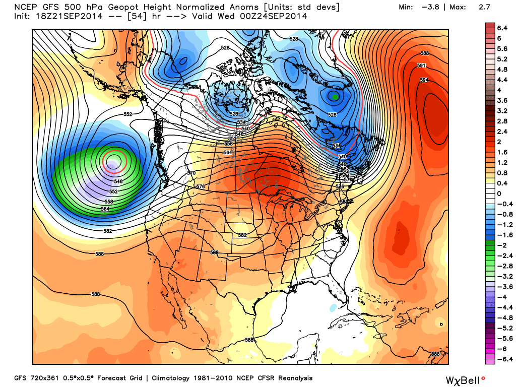
Here is the 1st trough to enter the Pac. NW around mid-week this week. A strong mid-level ridge develops in response, bringing temp departures from normal skyrocketing in the upper Midwest and south-central Canada as high as +10 to +15. In the northeast, we are likely to start the week slightly below average thanks to a short trough behind the cold front tomorrow night, but we will progressively warm up throughout the week and could see temps. in the weekend get back near the 80's.

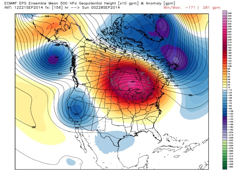
And the pattern continues into next week as well. Another train of trough's inhibit the EPO region and the combination of +EPO/+NAO should keep the northeast in a general average to above average state. Hence why I believe this month will ultimately finish above normal.

Another look at the temp. departures from normal. The southern and western U.S. is where the below average temps. will be confined. You can see our area is kind of in between, favoring above normal.
And while in the midst of this above normal temp. regime (generally), we will also remain mainly dry. However, I can see how at the end of the month the ridging in the eastern CONUS could lead to the development of a tropical entity to effect the country later this month or early October. There is some signal on current guidance of a coastal storm the very end of September. Still too early to know for certain, but I think the pattern the end of this month calls for some type of organized storm. Rain would be welcoming for most. We'll see what happens.
Enjoy the tranquility for now.
_________________
_______________________________________________________________________________________________________
CLICK HERE to view NJ Strong Snowstorm Classifications
Frank_Wx- Godzilla Seeker
- Posts : 21305
Reputation : 328
Join date : 2013-01-05
Age : 31
Location : Jersey City, NJ -
Re: Official Long Range Thread 3.0
![]() by Isotherm Sun Sep 21, 2014 10:11 pm
by Isotherm Sun Sep 21, 2014 10:11 pm
Global signaling seems to suggest at least a temporary relaxation in the cooler temperatures as you noted. +EPO coinciding w/ a +AO/NAO pulse will tighten the jet and retrograde the mean trough into the PAC NW for the next week to 10 days. I'd expect a rather mild first week of October as well (would be an Indian summer type pattern if we had our first frosts).
Summer's close to being dead, but not just yet. Usually I say you can be guaranteed to not need the A/C post October 10th (safe until April 10th, 6 months later). Late September / early October often features the last gasp of summery weather at this latitude (temps in the 80s, high dew points).
Isotherm- Advanced Forecaster
- Posts : 231
Reputation : 4
Join date : 2014-09-01
Age : 33
Location : Monmouth County, NJ -
Re: Official Long Range Thread 3.0
![]() by HectorO Tue Sep 23, 2014 11:53 am
by HectorO Tue Sep 23, 2014 11:53 am
HectorO- Pro Enthusiast
- Posts : 959
Reputation : 27
Join date : 2013-01-11
Page 13 of 32 • 1 ... 8 ... 12, 13, 14 ... 22 ... 32 ![]()
|
|
|