
 Search
Official Long Range Thread 3.0
Page 14 of 32 •  1 ... 8 ... 13, 14, 15 ... 23 ... 32
 ![]()
Re: Official Long Range Thread 3.0
![]() by Isotherm Sun Sep 21, 2014 10:11 pm
by Isotherm Sun Sep 21, 2014 10:11 pm
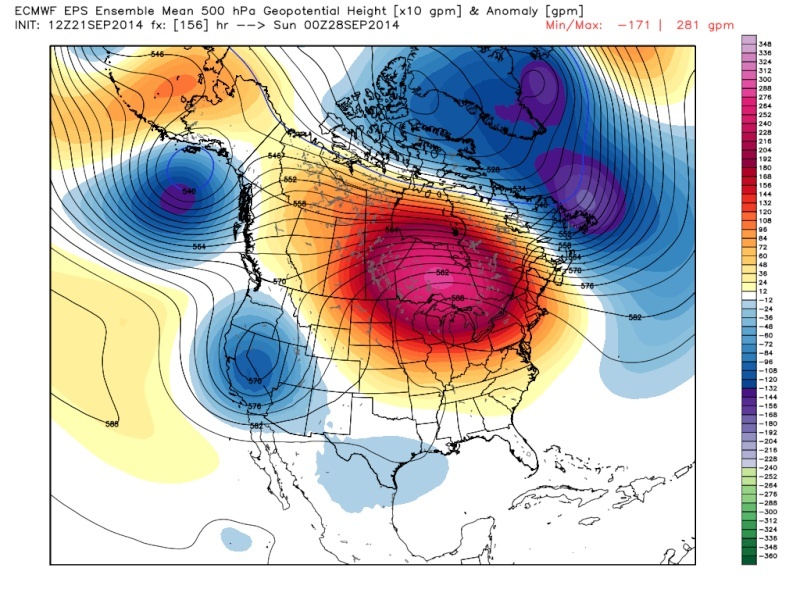
Global signaling seems to suggest at least a temporary relaxation in the cooler temperatures as you noted. +EPO coinciding w/ a +AO/NAO pulse will tighten the jet and retrograde the mean trough into the PAC NW for the next week to 10 days. I'd expect a rather mild first week of October as well (would be an Indian summer type pattern if we had our first frosts).
Summer's close to being dead, but not just yet. Usually I say you can be guaranteed to not need the A/C post October 10th (safe until April 10th, 6 months later). Late September / early October often features the last gasp of summery weather at this latitude (temps in the 80s, high dew points).
Isotherm- Advanced Forecaster

- Posts : 231
Join date : 2014-09-01 -

Re: Official Long Range Thread 3.0
![]() by HectorO Tue Sep 23, 2014 11:53 am
by HectorO Tue Sep 23, 2014 11:53 am
HectorO- Pro Enthusiast

- Posts : 959
Join date : 2013-01-11
Re: Official Long Range Thread 3.0
![]() by algae888 Wed Sep 24, 2014 2:36 pm
by algae888 Wed Sep 24, 2014 2:36 pm

algae888- Advanced Forecaster
- Posts : 5311
Reputation : 46
Join date : 2013-02-05
Age : 61
Location : mt. vernon, new york
Re: Official Long Range Thread 3.0
![]() by HectorO Thu Sep 25, 2014 1:23 pm
by HectorO Thu Sep 25, 2014 1:23 pm

HectorO- Pro Enthusiast
- Posts : 959
Reputation : 27
Join date : 2013-01-11
Re: Official Long Range Thread 3.0
![]() by jmanley32 Thu Sep 25, 2014 3:47 pm
by jmanley32 Thu Sep 25, 2014 3:47 pm

jmanley32- Senior Enthusiast

- Posts : 20516
Reputation : 108
Join date : 2013-12-12
Age : 42
Location : Yonkers, NY
Re: Official Long Range Thread 3.0
![]() by docstox12 Thu Sep 25, 2014 3:54 pm
by docstox12 Thu Sep 25, 2014 3:54 pm
Agree, though, it did look nice with the red, yellow and orange leaves.

docstox12- Wx Statistician Guru

- Posts : 8504
Reputation : 222
Join date : 2013-01-07
Age : 73
Location : Monroe NY
Re: Official Long Range Thread 3.0
![]() by Frank_Wx Thu Sep 25, 2014 5:36 pm
by Frank_Wx Thu Sep 25, 2014 5:36 pm

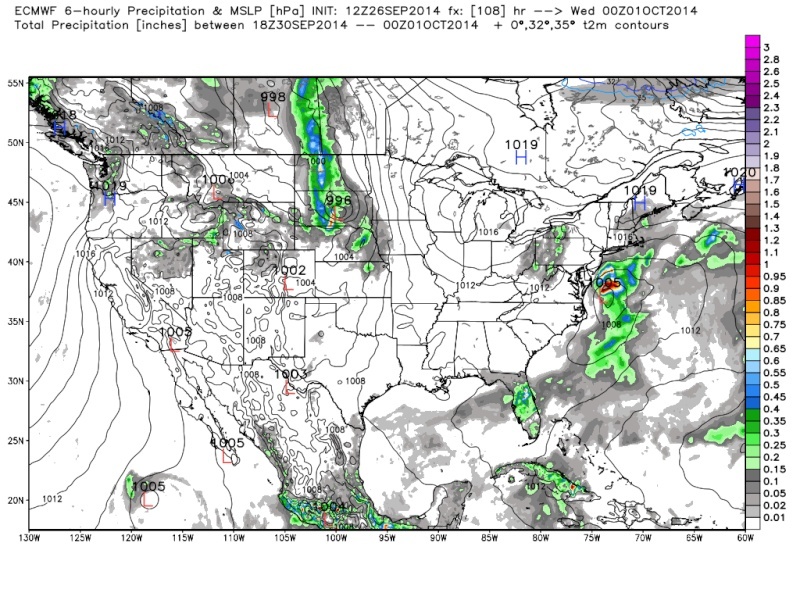
Weather this weekend into next week looks pleasant, with temps. mainly around average. Even though there is a trough in the western U.S, there looks to be a split-flowish looking pattern in the east with negative heights in the southeast and normal to positive heights in the northeast.
Beyond that, it looks fairly progressive with more chances for rain once we get into October.
_________________
_______________________________________________________________________________________________________
CLICK HERE to view NJ Strong Snowstorm Classifications

Frank_Wx- Godzilla Seeker

- Posts : 21305
Reputation : 328
Join date : 2013-01-05
Age : 31
Location : Jersey City, NJ -
Re: Official Long Range Thread 3.0
![]() by HectorO Fri Sep 26, 2014 12:34 pm
by HectorO Fri Sep 26, 2014 12:34 pm
jmanley32 wrote:So after this pathetic non-nopr easter any long range signs of any good storms headed our way? Patterns that would allow for one? Snow in October is fine with me, although alot of power outages I think it looks really cool on the trees. Maybe wait till November LOL. Nothing on mondels looks remotely interesting at this time.
God no, decent snow in October has a bad taste in all of our mouths. It's like a curse, we don't get snow again for like months after it happens. That one a few years ago was followed by one of the worst winters I can remember.
HectorO- Pro Enthusiast
- Posts : 959
Reputation : 27
Join date : 2013-01-11
Re: Official Long Range Thread 3.0
![]() by docstox12 Fri Sep 26, 2014 1:35 pm
by docstox12 Fri Sep 26, 2014 1:35 pm
docstox12- Wx Statistician Guru
- Posts : 8504
Reputation : 222
Join date : 2013-01-07
Age : 73
Location : Monroe NY
Re: Official Long Range Thread 3.0
![]() by jmanley32 Fri Sep 26, 2014 2:52 pm
by jmanley32 Fri Sep 26, 2014 2:52 pm
jmanley32- Senior Enthusiast
- Posts : 20516
Reputation : 108
Join date : 2013-12-12
Age : 42
Location : Yonkers, NY

jmanley32- Senior Enthusiast
- Posts : 20516
Reputation : 108
Join date : 2013-12-12
Age : 42
Location : Yonkers, NY
Re: Official Long Range Thread 3.0
![]() by jmanley32 Fri Sep 26, 2014 2:55 pm
by jmanley32 Fri Sep 26, 2014 2:55 pm

jmanley32- Senior Enthusiast
- Posts : 20516
Reputation : 108
Join date : 2013-12-12
Age : 42
Location : Yonkers, NY
Re: Official Long Range Thread 3.0
![]() by jmanley32 Sat Sep 27, 2014 6:12 am
by jmanley32 Sat Sep 27, 2014 6:12 am

jmanley32- Senior Enthusiast
- Posts : 20516
Reputation : 108
Join date : 2013-12-12
Age : 42
Location : Yonkers, NY
jmanley32- Senior Enthusiast
- Posts : 20516
Reputation : 108
Join date : 2013-12-12
Age : 42
Location : Yonkers, NY
Re: Official Long Range Thread 3.0
![]() by docstox12 Sat Sep 27, 2014 6:53 am
by docstox12 Sat Sep 27, 2014 6:53 am
jmanley32 wrote:
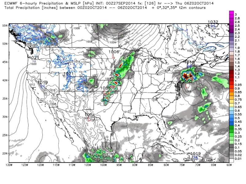
Wow! Haven't seen something like this in ages in this extended dry spell.That would give us some relief.
docstox12- Wx Statistician Guru
- Posts : 8504
Reputation : 222
Join date : 2013-01-07
Age : 73
Location : Monroe NY
Re: Official Long Range Thread 3.0
![]() by sroc4 Sat Sep 27, 2014 8:00 am
by sroc4 Sat Sep 27, 2014 8:00 am
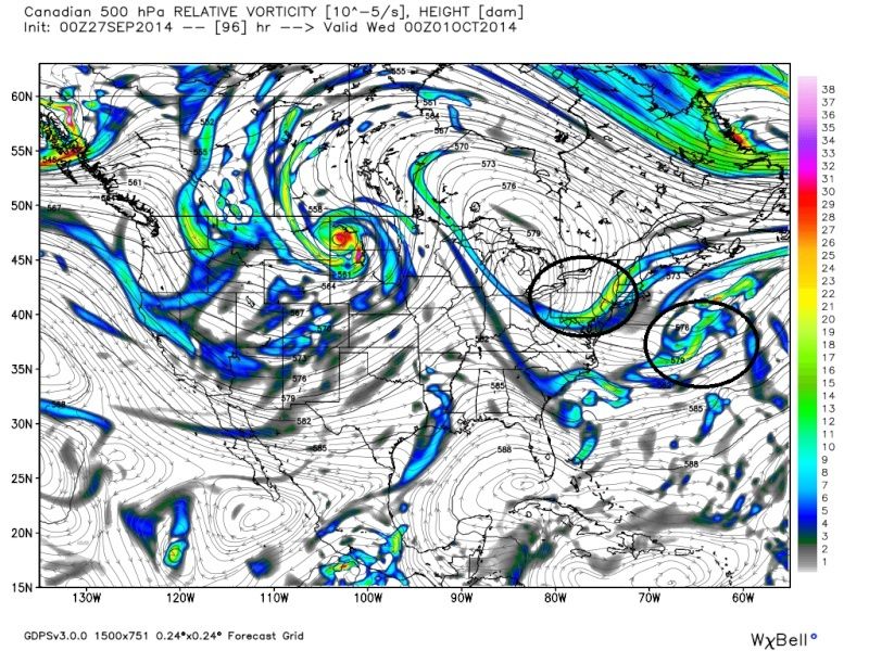
Euro 00z Tues:
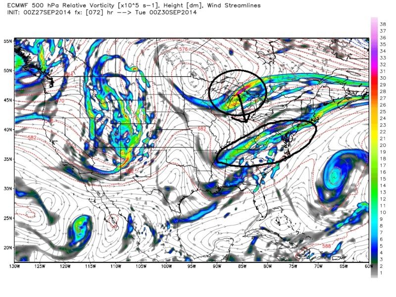 " />
" />Euro 00z Wed
 " />
" />GFS 00z Tues
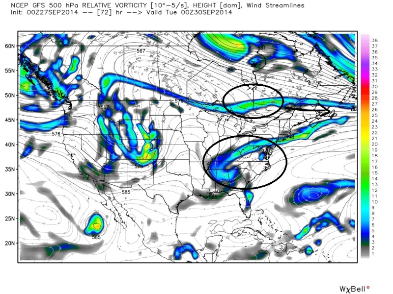 " />
" />GFS 00z Wed
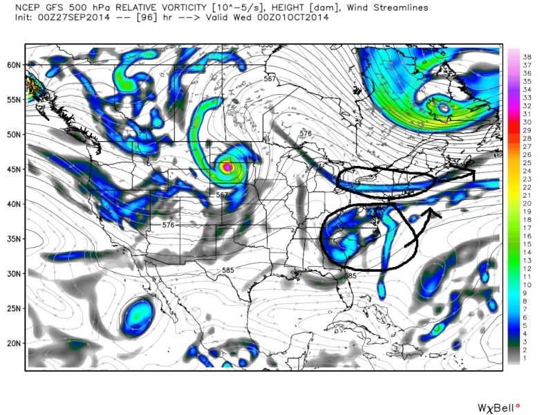 " />
" />CMC 00z Tues
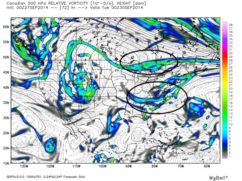 " />
" />CMC 00z Wed
 " />
" />_________________
"In weather and in life, there's no winning and losing; there's only winning and learning."
WINTER 2012/2013 TOTALS 43.65"WINTER 2017/2018 TOTALS 62.85" WINTER 2022/2023 TOTALS 4.9"
WINTER 2013/2014 TOTALS 64.85"WINTER 2018/2019 TOTALS 14.25" WINTER 2023/2024 TOTALS 13.1"
WINTER 2014/2015 TOTALS 71.20"WINTER 2019/2020 TOTALS 6.35"
WINTER 2015/2016 TOTALS 35.00"WINTER 2020/2021 TOTALS 37.75"
WINTER 2016/2017 TOTALS 42.25"WINTER 2021/2022 TOTALS 31.65"

sroc4- Admin
- Posts : 8331
Reputation : 301
Join date : 2013-01-07
Location : Wading River, LI
Re: Official Long Range Thread 3.0
![]() by sroc4 Sat Sep 27, 2014 8:05 am
by sroc4 Sat Sep 27, 2014 8:05 am
_________________
"In weather and in life, there's no winning and losing; there's only winning and learning."
WINTER 2012/2013 TOTALS 43.65"WINTER 2017/2018 TOTALS 62.85" WINTER 2022/2023 TOTALS 4.9"
WINTER 2013/2014 TOTALS 64.85"WINTER 2018/2019 TOTALS 14.25" WINTER 2023/2024 TOTALS 13.1"
WINTER 2014/2015 TOTALS 71.20"WINTER 2019/2020 TOTALS 6.35"
WINTER 2015/2016 TOTALS 35.00"WINTER 2020/2021 TOTALS 37.75"
WINTER 2016/2017 TOTALS 42.25"WINTER 2021/2022 TOTALS 31.65"
sroc4- Admin
- Posts : 8331
Reputation : 301
Join date : 2013-01-07
Location : Wading River, LI
Re: Official Long Range Thread 3.0
![]() by algae888 Sat Sep 27, 2014 8:08 am
by algae888 Sat Sep 27, 2014 8:08 am
algae888- Advanced Forecaster
- Posts : 5311
Reputation : 46
Join date : 2013-02-05
Age : 61
Location : mt. vernon, new york
Re: Official Long Range Thread 3.0
![]() by HectorO Sat Sep 27, 2014 3:45 pm
by HectorO Sat Sep 27, 2014 3:45 pm
HectorO- Pro Enthusiast
- Posts : 959
Reputation : 27
Join date : 2013-01-11
Re: Official Long Range Thread 3.0
![]() by Dtone Sat Sep 27, 2014 5:00 pm
by Dtone Sat Sep 27, 2014 5:00 pm
Dtone- Wx Statistician Guru
- Posts : 1738
Reputation : 9
Join date : 2013-08-26
Location : Bronx, NY
Re: Official Long Range Thread 3.0
![]() by amugs Sat Sep 27, 2014 9:39 pm
by amugs Sat Sep 27, 2014 9:39 pm
Both the GEFS and Euro ensembles agree on the -NAO building into the Greenland/Davis Strait around Oct. 5

_________________
Mugs
AKA:King: Snow Weenie
Self Proclaimed
WINTER 2014-15 : 55.12" +.02 for 6 coatings (avg. 35")
WINTER 2015-16 Total - 29.8" (Avg 35")
WINTER 2016-17 : 39.5" so far

amugs- Advanced Forecaster - Mod

- Posts : 15093
Reputation : 213
Join date : 2013-01-07
Age : 54
Location : Hillsdale,NJ
Re: Official Long Range Thread 3.0
![]() by nutleyblizzard Sun Sep 28, 2014 6:06 am
by nutleyblizzard Sun Sep 28, 2014 6:06 am
As we head into October, I start to pay more attention on pattern setups, as it often foretells the upcoming winter season. Two things that I'll be looking for (as far as a cold and snowy winter), will be a sustained -NAO/-AO regime, and coastal storm developments.amugs wrote:
Both the GEFS and Euro ensembles agree on the -NAO building into the Greenland/Davis Strait around Oct. 5

nutleyblizzard- Senior Enthusiast
- Posts : 1952
Reputation : 41
Join date : 2014-01-30
Age : 58
Location : Nutley, new jersey
Re: Official Long Range Thread 3.0
![]() by sroc4 Sun Sep 28, 2014 8:25 am
by sroc4 Sun Sep 28, 2014 8:25 am
nutleyblizzard wrote:As we head into October, I start to pay more attention on pattern setups, as it often foretells the upcoming winter season. Two things that I'll be looking for (as far as a cold and snowy winter), will be a sustained -NAO/-AO regime, and coastal storm developments.amugs wrote:
Both the GEFS and Euro ensembles agree on the -NAO building into the Greenland/Davis Strait around Oct. 5
This was Steve Demartino's write up regarding the current snow growth status in N Canada and Siberia...encouraging to say the least.
 " />
" />SNOW GROWTH UPDATE! Okay, everyone cheer.
Seriously, this is the one missing component for me to make my winter forecast which will be out around October 20th. What we are seeing today is really a good sign if you love cold and snowy weather patterns. If not, well stock up on soup and hot coco.
The latest analysis shows significant above normal snow anomalies in Siberia and northern Canada. Note the areas in white stand for near normal levels so that simply means the rest of North America is at climatological norms. Meanwhile, there is very little in the way of below normal anomalies over North America. Basically there are two small areas, both of which have little significance on the development of Polar/Arctic air masses. It is the area over Siberia that really catches my eye. Snowfall departures are above normal in these locations and have grown significantly over the past week. These types of anomalies continue into October and we are setting up an environment for a robust and dominating invasion of Polar and Arctic air masses into the United States. Take these factors and combine with my discussion from yesterday about our coastal low and I think you see where I am going here.
So two weeks in and we are well above normal so far in snow growth. We still have to monitor the first two weeks of October and then I'll have the data I need. Why two weeks? Well, I have seen plenty of years where the snow growth has started off strong only to be destroyed by a Pacific air mass, so we can't jump the gun yet. If these anomalies persist and grow in mid October then we have established the base needed to support a forecast for a cold and snowy winter. Think of this like the first layer of paint to get the base established.
_________________
"In weather and in life, there's no winning and losing; there's only winning and learning."
WINTER 2012/2013 TOTALS 43.65"WINTER 2017/2018 TOTALS 62.85" WINTER 2022/2023 TOTALS 4.9"
WINTER 2013/2014 TOTALS 64.85"WINTER 2018/2019 TOTALS 14.25" WINTER 2023/2024 TOTALS 13.1"
WINTER 2014/2015 TOTALS 71.20"WINTER 2019/2020 TOTALS 6.35"
WINTER 2015/2016 TOTALS 35.00"WINTER 2020/2021 TOTALS 37.75"
WINTER 2016/2017 TOTALS 42.25"WINTER 2021/2022 TOTALS 31.65"
sroc4- Admin
- Posts : 8331
Reputation : 301
Join date : 2013-01-07
Location : Wading River, LI
Re: Official Long Range Thread 3.0
![]() by jmanley32 Sun Sep 28, 2014 12:29 pm
by jmanley32 Sun Sep 28, 2014 12:29 pm
jmanley32- Senior Enthusiast
- Posts : 20516
Reputation : 108
Join date : 2013-12-12
Age : 42
Location : Yonkers, NY
Re: Official Long Range Thread 3.0
![]() by amugs Sun Sep 28, 2014 3:33 pm
by amugs Sun Sep 28, 2014 3:33 pm
Thanks for the information. I was going to pull some research out on this the first week of October when a s Demartino says is prime time to see where we are and do a comparison at the end of oct and mid and end of nov. with hat so pronged to go negative and it looks like is will be sustained for a good week + ( we must have patience and faith) then things could get interesting.
Btw great write up about the coastal- a few days to early but maybe the reason why the NAO goes negative?
If you want to read a good scientific climo synopsis take a look at what i posted in the winter outlook thread. He says its coming!
_________________
Mugs
AKA:King: Snow Weenie
Self Proclaimed
WINTER 2014-15 : 55.12" +.02 for 6 coatings (avg. 35")
WINTER 2015-16 Total - 29.8" (Avg 35")
WINTER 2016-17 : 39.5" so far
amugs- Advanced Forecaster - Mod
- Posts : 15093
Reputation : 213
Join date : 2013-01-07
Age : 54
Location : Hillsdale,NJ
Re: Official Long Range Thread 3.0
![]() by amugs Sun Sep 28, 2014 3:47 pm
by amugs Sun Sep 28, 2014 3:47 pm
Read this article - interesting about the retraction of arctic sea ice and how it correlates to the NAO modulation.
_________________
Mugs
AKA:King: Snow Weenie
Self Proclaimed
WINTER 2014-15 : 55.12" +.02 for 6 coatings (avg. 35")
WINTER 2015-16 Total - 29.8" (Avg 35")
WINTER 2016-17 : 39.5" so far
amugs- Advanced Forecaster - Mod
- Posts : 15093
Reputation : 213
Join date : 2013-01-07
Age : 54
Location : Hillsdale,NJ
Re: Official Long Range Thread 3.0
![]() by jmanley32 Sun Sep 28, 2014 3:53 pm
by jmanley32 Sun Sep 28, 2014 3:53 pm
jmanley32- Senior Enthusiast
- Posts : 20516
Reputation : 108
Join date : 2013-12-12
Age : 42
Location : Yonkers, NY
Page 14 of 32 • 1 ... 8 ... 13, 14, 15 ... 23 ... 32 ![]()
|
|
|