
 Search
Official Long Range Thread 3.0
Page 21 of 32 •  1 ... 12 ... 20, 21, 22 ... 26 ... 32
 ![]()
Re: Official Long Range Thread 3.0
![]() by amugs Thu Oct 09, 2014 9:37 am
by amugs Thu Oct 09, 2014 9:37 am
For teh rest of us - what does this look like on the euro 7 days out ??

amugs- Advanced Forecaster - Mod

- Posts : 15093
Join date : 2013-01-07
amugs- Advanced Forecaster - Mod
- Posts : 15093
Join date : 2013-01-07
Re: Official Long Range Thread 3.0
![]() by jmanley32 Thu Oct 09, 2014 1:32 pm
by jmanley32 Thu Oct 09, 2014 1:32 pm

jmanley32- Senior Enthusiast

- Posts : 20517
Reputation : 108
Join date : 2013-12-12
Age : 42
Location : Yonkers, NY
Re: Official Long Range Thread 3.0
![]() by jmanley32 Fri Oct 10, 2014 1:15 am
by jmanley32 Fri Oct 10, 2014 1:15 am
http://www.wsi.com/blog/energy/upcoming-window-for-atlantic-tropical-cyclone-development-the-7-14-day-tropical-cyclogenesis-risk-outlook-1014-1021/
jmanley32- Senior Enthusiast
- Posts : 20517
Reputation : 108
Join date : 2013-12-12
Age : 42
Location : Yonkers, NY
Re: Official Long Range Thread 3.0
![]() by sroc4 Fri Oct 10, 2014 12:36 pm
by sroc4 Fri Oct 10, 2014 12:36 pm
Giggidy!
http://www.abc2news.com/weather/weather-blogs/all-time-record-north-america-snow-cover-hits-45-year-high
_________________
"In weather and in life, there's no winning and losing; there's only winning and learning."
WINTER 2012/2013 TOTALS 43.65"WINTER 2017/2018 TOTALS 62.85" WINTER 2022/2023 TOTALS 4.9"
WINTER 2013/2014 TOTALS 64.85"WINTER 2018/2019 TOTALS 14.25" WINTER 2023/2024 TOTALS 13.1"
WINTER 2014/2015 TOTALS 71.20"WINTER 2019/2020 TOTALS 6.35"
WINTER 2015/2016 TOTALS 35.00"WINTER 2020/2021 TOTALS 37.75"
WINTER 2016/2017 TOTALS 42.25"WINTER 2021/2022 TOTALS 31.65"

sroc4- Admin

- Posts : 8331
Reputation : 301
Join date : 2013-01-07
Location : Wading River, LI
Re: Official Long Range Thread 3.0
![]() by amugs Fri Oct 10, 2014 1:20 pm
by amugs Fri Oct 10, 2014 1:20 pm
sroc4 wrote:Steve D just mentioned this as well in his latest outlooks.
Giggidy!
http://www.abc2news.com/weather/weather-blogs/all-time-record-north-america-snow-cover-hits-45-year-high
Saw that as well yesterday in a blog - great stuff - will propagate cold and hopefully pattern will induce precip for us snow weenies!!

_________________
Mugs
AKA:King: Snow Weenie
Self Proclaimed
WINTER 2014-15 : 55.12" +.02 for 6 coatings (avg. 35")
WINTER 2015-16 Total - 29.8" (Avg 35")
WINTER 2016-17 : 39.5" so far

amugs- Advanced Forecaster - Mod
- Posts : 15093
Reputation : 213
Join date : 2013-01-07
Age : 54
Location : Hillsdale,NJ
Re: Official Long Range Thread 3.0
![]() by jmanley32 Fri Oct 10, 2014 2:26 pm
by jmanley32 Fri Oct 10, 2014 2:26 pm
jmanley32- Senior Enthusiast
- Posts : 20517
Reputation : 108
Join date : 2013-12-12
Age : 42
Location : Yonkers, NY
Re: Official Long Range Thread 3.0
![]() by amugs Fri Oct 10, 2014 3:18 pm
by amugs Fri Oct 10, 2014 3:18 pm

_________________
Mugs
AKA:King: Snow Weenie
Self Proclaimed
WINTER 2014-15 : 55.12" +.02 for 6 coatings (avg. 35")
WINTER 2015-16 Total - 29.8" (Avg 35")
WINTER 2016-17 : 39.5" so far
amugs- Advanced Forecaster - Mod
- Posts : 15093
Reputation : 213
Join date : 2013-01-07
Age : 54
Location : Hillsdale,NJ
Re: Official Long Range Thread 3.0
![]() by jmanley32 Fri Oct 10, 2014 4:08 pm
by jmanley32 Fri Oct 10, 2014 4:08 pm
jmanley32- Senior Enthusiast
- Posts : 20517
Reputation : 108
Join date : 2013-12-12
Age : 42
Location : Yonkers, NY
Re: Official Long Range Thread 3.0
![]() by sroc4 Fri Oct 10, 2014 4:46 pm
by sroc4 Fri Oct 10, 2014 4:46 pm
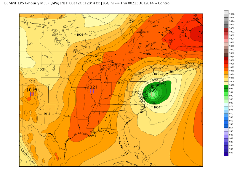
amugs wrote:Next week - huge cut off low on the Euro - mid to latter part.
Take notice of the LP just north of eastern Cuba. Now Look at the position of the ridge off the NE coast (HP on the surface map), and look at the position of the ULL on the 500mb map centered over Indiana-ish, and look at the alley in between. Counter clockwise flow around the ULL and clockwise around the ridge(HP) could draw that tropical LP right up the gut and make things interesting. If If IF IF that 500mb soln were to verify of course. LOOOONNGG way to go. For now we watch. But I am intrigued by this set up given the MJO and some of the other teles
_________________
"In weather and in life, there's no winning and losing; there's only winning and learning."
WINTER 2012/2013 TOTALS 43.65"WINTER 2017/2018 TOTALS 62.85" WINTER 2022/2023 TOTALS 4.9"
WINTER 2013/2014 TOTALS 64.85"WINTER 2018/2019 TOTALS 14.25" WINTER 2023/2024 TOTALS 13.1"
WINTER 2014/2015 TOTALS 71.20"WINTER 2019/2020 TOTALS 6.35"
WINTER 2015/2016 TOTALS 35.00"WINTER 2020/2021 TOTALS 37.75"
WINTER 2016/2017 TOTALS 42.25"WINTER 2021/2022 TOTALS 31.65"
sroc4- Admin
- Posts : 8331
Reputation : 301
Join date : 2013-01-07
Location : Wading River, LI
Re: Official Long Range Thread 3.0
![]() by skinsfan1177 Fri Oct 10, 2014 5:12 pm
by skinsfan1177 Fri Oct 10, 2014 5:12 pm
sroc4 wrote:amugs wrote:Next week - huge cut off low on the Euro - mid to latter part.
Take notice of the LP just north of eastern Cuba. Now Look at the position of the ridge off the NE coast (HP on the surface map), and look at the position of the ULL on the 500mb map centered over Indiana-ish, and look at the alley in between. Counter clockwise flow around the ULL and clockwise around the ridge(HP) could draw that tropical LP right up the gut and make things interesting. If If IF IF that 500mb soln were to verify of course. LOOOONNGG way to go. For now we watch. But I am intrigued by this set up given the MJO and some of the other teles
So sroc4 that high in the atlantic if it verified would act like a block correct and steer the storm toward the coast correct

skinsfan1177- Senior Enthusiast
- Posts : 4485
Reputation : 35
Join date : 2013-01-07
Age : 46
Location : Point Pleasant Boro
Re: Official Long Range Thread 3.0
![]() by amugs Fri Oct 10, 2014 5:15 pm
by amugs Fri Oct 10, 2014 5:15 pm
sroc4 wrote:amugs wrote:Next week - huge cut off low on the Euro - mid to latter part.
Take notice of the LP just north of eastern Cuba. Now Look at the position of the ridge off the NE coast (HP on the surface map), and look at the position of the ULL on the 500mb map centered over Indiana-ish, and look at the alley in between. Counter clockwise flow around the ULL and clockwise around the ridge(HP) could draw that tropical LP right up the gut and make things interesting. If If IF IF that 500mb soln were to verify of course. LOOOONNGG way to go. For now we watch. But I am intrigued by this set up given the MJO and some of the other teles
Scott could not have explained it better meself !! Thank you oh great color analysis!
If this holds say by Sunday and the runs of Monday - then we get some action finally to look at instead of the yawners!!

_________________
Mugs
AKA:King: Snow Weenie
Self Proclaimed
WINTER 2014-15 : 55.12" +.02 for 6 coatings (avg. 35")
WINTER 2015-16 Total - 29.8" (Avg 35")
WINTER 2016-17 : 39.5" so far
amugs- Advanced Forecaster - Mod
- Posts : 15093
Reputation : 213
Join date : 2013-01-07
Age : 54
Location : Hillsdale,NJ
Re: Official Long Range Thread 3.0
![]() by jmanley32 Fri Oct 10, 2014 5:17 pm
by jmanley32 Fri Oct 10, 2014 5:17 pm
jmanley32- Senior Enthusiast
- Posts : 20517
Reputation : 108
Join date : 2013-12-12
Age : 42
Location : Yonkers, NY
Re: Official Long Range Thread 3.0
![]() by sroc4 Fri Oct 10, 2014 5:53 pm
by sroc4 Fri Oct 10, 2014 5:53 pm
skinsfan1177 wrote:sroc4 wrote:amugs wrote:Next week - huge cut off low on the Euro - mid to latter part.
Take notice of the LP just north of eastern Cuba. Now Look at the position of the ridge off the NE coast (HP on the surface map), and look at the position of the ULL on the 500mb map centered over Indiana-ish, and look at the alley in between. Counter clockwise flow around the ULL and clockwise around the ridge(HP) could draw that tropical LP right up the gut and make things interesting. If If IF IF that 500mb soln were to verify of course. LOOOONNGG way to go. For now we watch. But I am intrigued by this set up given the MJO and some of the other teles
So sroc4 that high in the atlantic if it verified would act like a block correct and steer the storm toward the coast correct
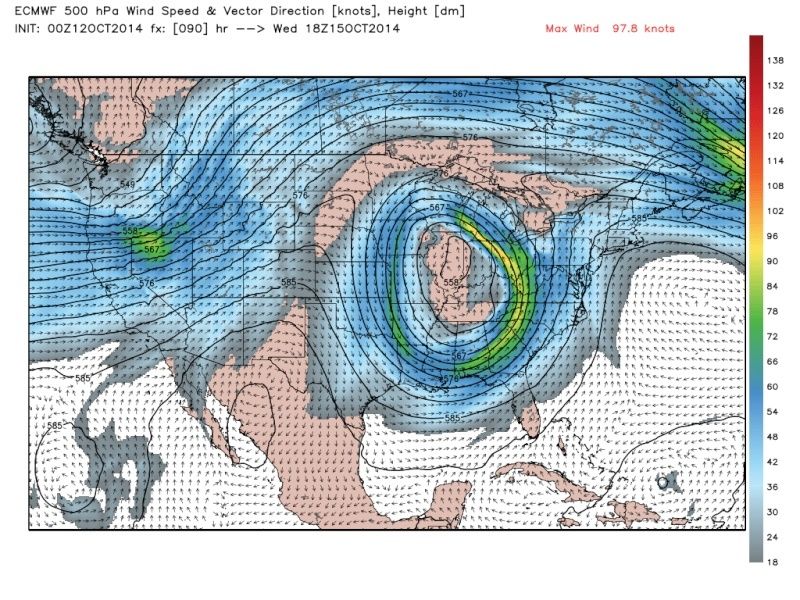
Skins. I would say could instead of would, but yes exactly. What need to happen though is the ULL and its associated trough needs to draw the storm up. But that doesnt happen on this run. What is not shown by the image is that the run continues and shows that energy being left behind and the ULL lifts up and out taking the blocking along with it. That tropical LP meanders about 24hrs or so in that general vicinity until another weaker trough dives in over the plains. The eastern side of the trough is very progressive and by about the 19th/20th on the run the tropical system gets caught up in the flow and turns OTS.
[img]
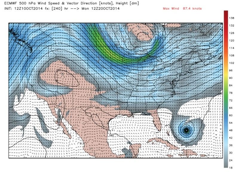 [/img]
If that system will influence us it has to be picked up by the sharp trough associated with that ULL in the image in the time frame between Oct 15th-17th/18th or so. If you buy the run verbatim it misses that trough meanders a day or two then is picked up by the next one coming in around the 19th.
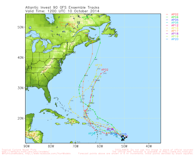
JMan number one on this map is what will potentially become the system in question.

I wouldn't get all excited by this just yet. Its something on the models. As currently modeled by the European its something only the Bahamas and Turks and Caicos need to be worried with. So with that I continue to watch.
_________________
"In weather and in life, there's no winning and losing; there's only winning and learning."
WINTER 2012/2013 TOTALS 43.65"WINTER 2017/2018 TOTALS 62.85" WINTER 2022/2023 TOTALS 4.9"
WINTER 2013/2014 TOTALS 64.85"WINTER 2018/2019 TOTALS 14.25" WINTER 2023/2024 TOTALS 13.1"
WINTER 2014/2015 TOTALS 71.20"WINTER 2019/2020 TOTALS 6.35"
WINTER 2015/2016 TOTALS 35.00"WINTER 2020/2021 TOTALS 37.75"
WINTER 2016/2017 TOTALS 42.25"WINTER 2021/2022 TOTALS 31.65"
sroc4- Admin
- Posts : 8331
Reputation : 301
Join date : 2013-01-07
Location : Wading River, LI
Re: Official Long Range Thread 3.0
![]() by jmanley32 Fri Oct 10, 2014 6:24 pm
by jmanley32 Fri Oct 10, 2014 6:24 pm
jmanley32- Senior Enthusiast
- Posts : 20517
Reputation : 108
Join date : 2013-12-12
Age : 42
Location : Yonkers, NY
Re: Official Long Range Thread 3.0
![]() by jmanley32 Fri Oct 10, 2014 6:27 pm
by jmanley32 Fri Oct 10, 2014 6:27 pm
jmanley32- Senior Enthusiast
- Posts : 20517
Reputation : 108
Join date : 2013-12-12
Age : 42
Location : Yonkers, NY
Re: Official Long Range Thread 3.0
![]() by algae888 Sat Oct 11, 2014 8:34 am
by algae888 Sat Oct 11, 2014 8:34 am
http://www.accuweather.com/en/weather-blogs/anderson/forecast-model-update-into-the-winter/35382077

algae888- Advanced Forecaster

- Posts : 5311
Reputation : 46
Join date : 2013-02-05
Age : 61
Location : mt. vernon, new york
Re: Official Long Range Thread 3.0
![]() by amugs Sun Oct 12, 2014 8:04 am
by amugs Sun Oct 12, 2014 8:04 am

_________________
Mugs
AKA:King: Snow Weenie
Self Proclaimed
WINTER 2014-15 : 55.12" +.02 for 6 coatings (avg. 35")
WINTER 2015-16 Total - 29.8" (Avg 35")
WINTER 2016-17 : 39.5" so far
amugs- Advanced Forecaster - Mod
- Posts : 15093
Reputation : 213
Join date : 2013-01-07
Age : 54
Location : Hillsdale,NJ
Re: Official Long Range Thread 3.0
![]() by jmanley32 Sun Oct 12, 2014 8:35 am
by jmanley32 Sun Oct 12, 2014 8:35 am
jmanley32- Senior Enthusiast
- Posts : 20517
Reputation : 108
Join date : 2013-12-12
Age : 42
Location : Yonkers, NY
Re: Official Long Range Thread 3.0
![]() by jmanley32 Sun Oct 12, 2014 8:42 am
by jmanley32 Sun Oct 12, 2014 8:42 am
jmanley32- Senior Enthusiast
- Posts : 20517
Reputation : 108
Join date : 2013-12-12
Age : 42
Location : Yonkers, NY
Re: Official Long Range Thread 3.0
![]() by jmanley32 Sun Oct 12, 2014 9:07 am
by jmanley32 Sun Oct 12, 2014 9:07 am
jmanley32- Senior Enthusiast
- Posts : 20517
Reputation : 108
Join date : 2013-12-12
Age : 42
Location : Yonkers, NY
Re: Official Long Range Thread 3.0
![]() by sroc4 Sun Oct 12, 2014 9:13 am
by sroc4 Sun Oct 12, 2014 9:13 am
 " />
" />Zoom out even further and look towards Jupiter. Yes Jupiter. The Red dot on Jupiter is a swirling storm of gases that is bigger than the earth! Think about that for a second.

Lets zoom out even further!! Now look at the Milky Way. Our galaxy. It too swirls round and round a center on a scale that is barely comprehensible for us teenie weenie, ity bitty not even a fleck in this vast crazy universe.

When you think about the philosophical question of how all of this all works the common theme is its all driven by circular motion. The upper level closed low above would not be possible if not for the rotation of the earth around its axis right? We as humans seem pretty confident in that right? So what about the universe? What forces drive the formation of galaxies and there rotational motion? Think about the motion of two galaxies in close proximity to each other. There are actually images of galaxies exhibiting the Fujiwhara Effect. The National Weather Service defines the Fujiwhara Effect as the tendency of two nearby tropical cyclones to rotate cyclonically about each other.


Yes this is the kind of stuff that when I am alone on Sunday morning drinking my coffee I ponder. Dork to the max maybe, but if you stop to really try and think about it and the scale at which it all occurs...poof!! Mind blown. Carry on
Last edited by sroc4 on Sun Oct 12, 2014 11:15 am; edited 1 time in total
_________________
"In weather and in life, there's no winning and losing; there's only winning and learning."
WINTER 2012/2013 TOTALS 43.65"WINTER 2017/2018 TOTALS 62.85" WINTER 2022/2023 TOTALS 4.9"
WINTER 2013/2014 TOTALS 64.85"WINTER 2018/2019 TOTALS 14.25" WINTER 2023/2024 TOTALS 13.1"
WINTER 2014/2015 TOTALS 71.20"WINTER 2019/2020 TOTALS 6.35"
WINTER 2015/2016 TOTALS 35.00"WINTER 2020/2021 TOTALS 37.75"
WINTER 2016/2017 TOTALS 42.25"WINTER 2021/2022 TOTALS 31.65"
sroc4- Admin
- Posts : 8331
Reputation : 301
Join date : 2013-01-07
Location : Wading River, LI
Re: Official Long Range Thread 3.0
![]() by algae888 Sun Oct 12, 2014 10:00 am
by algae888 Sun Oct 12, 2014 10:00 am
algae888- Advanced Forecaster
- Posts : 5311
Reputation : 46
Join date : 2013-02-05
Age : 61
Location : mt. vernon, new york
Re: Official Long Range Thread 3.0
![]() by Frank_Wx Sun Oct 12, 2014 10:13 am
by Frank_Wx Sun Oct 12, 2014 10:13 am
_________________
_______________________________________________________________________________________________________
CLICK HERE to view NJ Strong Snowstorm Classifications

Frank_Wx- Godzilla Seeker
- Posts : 21305
Reputation : 328
Join date : 2013-01-05
Age : 31
Location : Jersey City, NJ -

Re: Official Long Range Thread 3.0
![]() by amugs Sun Oct 12, 2014 1:16 pm
by amugs Sun Oct 12, 2014 1:16 pm

_________________
Mugs
AKA:King: Snow Weenie
Self Proclaimed
WINTER 2014-15 : 55.12" +.02 for 6 coatings (avg. 35")
WINTER 2015-16 Total - 29.8" (Avg 35")
WINTER 2016-17 : 39.5" so far
amugs- Advanced Forecaster - Mod
- Posts : 15093
Reputation : 213
Join date : 2013-01-07
Age : 54
Location : Hillsdale,NJ
Re: Official Long Range Thread 3.0
![]() by jmanley32 Sun Oct 12, 2014 3:07 pm
by jmanley32 Sun Oct 12, 2014 3:07 pm
jmanley32- Senior Enthusiast
- Posts : 20517
Reputation : 108
Join date : 2013-12-12
Age : 42
Location : Yonkers, NY
Re: Official Long Range Thread 3.0
![]() by jmanley32 Sun Oct 12, 2014 3:10 pm
by jmanley32 Sun Oct 12, 2014 3:10 pm
jmanley32- Senior Enthusiast
- Posts : 20517
Reputation : 108
Join date : 2013-12-12
Age : 42
Location : Yonkers, NY
Page 21 of 32 • 1 ... 12 ... 20, 21, 22 ... 26 ... 32 ![]()
|
|
|