
 Search
Official Long Range Thread 3.0
Page 20 of 32 •  1 ... 11 ... 19, 20, 21 ... 26 ... 32
 ![]()
Re: Official Long Range Thread 3.0
![]() by jmanley32 Tue Oct 07, 2014 9:06 pm
by jmanley32 Tue Oct 07, 2014 9:06 pm
jmanley32- Senior Enthusiast

- Posts : 20516
Join date : 2013-12-12
Re: Official Long Range Thread 3.0
![]() by HectorO Tue Oct 07, 2014 9:47 pm
by HectorO Tue Oct 07, 2014 9:47 pm
jmanley32 wrote:I am aware Quietace, i do not think a Sandy 2 would be anybodys fantasy. Anythoughts on the second post which is much closer in time?
I agree, but there are people with sick fantasies lol.
HectorO- Pro Enthusiast

- Posts : 959
Join date : 2013-01-11
Re: Official Long Range Thread 3.0
![]() by jmanley32 Tue Oct 07, 2014 10:02 pm
by jmanley32 Tue Oct 07, 2014 10:02 pm

jmanley32- Senior Enthusiast
- Posts : 20516
Reputation : 108
Join date : 2013-12-12
Age : 42
Location : Yonkers, NY
Re: Official Long Range Thread 3.0
![]() by SNOW MAN Wed Oct 08, 2014 5:35 am
by SNOW MAN Wed Oct 08, 2014 5:35 am

SNOW MAN- Senior Enthusiast
- Posts : 1361
Reputation : 25
Join date : 2013-01-13
Age : 64
Location : Marshalls Creek Pa.
Re: Official Long Range Thread 3.0
![]() by Isotherm Wed Oct 08, 2014 10:31 am
by Isotherm Wed Oct 08, 2014 10:31 am
Isotherm- Advanced Forecaster

- Posts : 231
Reputation : 4
Join date : 2014-09-01
Age : 33
Location : Monmouth County, NJ -

Re: Official Long Range Thread 3.0
![]() by nutleyblizzard Wed Oct 08, 2014 12:49 pm
by nutleyblizzard Wed Oct 08, 2014 12:49 pm
If the EL Nino fails to develop and we end up neutral, our tele connectors become of more importance. We need to strive for a dominate +PNA/-NAO/-AO regime and then we will be in good shape.Frank_Wx wrote:algae888 wrote:stevie d believes el-nino will not be a driving factor in the 500mb pattern for this winter. says models have done poor job of forecasting it. he thinks sst in northern pac and stratospheric warming will be key factors and if el-nino develops it will enhance the pattern. so does this mean we can expect a warmer and less active winter?
I have been monitoring the SST's in the ENSO region on a weekly basis. They are not making the progress I expected them too, and as of now, the diagnostic an statistical models are busting badly. ENSO region 3.4 as of last week was at +0.3, though region 1+2 is up to +1.0. However, region 3.4 is most important. I stll think it is too early. I want the rest of October and 1st half of November to finish out before concluding El Nino will not be a driving factor this winter.

nutleyblizzard- Senior Enthusiast
- Posts : 1952
Reputation : 41
Join date : 2014-01-30
Age : 58
Location : Nutley, new jersey
Re: Official Long Range Thread 3.0
![]() by jmanley32 Wed Oct 08, 2014 1:40 pm
by jmanley32 Wed Oct 08, 2014 1:40 pm

jmanley32- Senior Enthusiast
- Posts : 20516
Reputation : 108
Join date : 2013-12-12
Age : 42
Location : Yonkers, NY
Re: Official Long Range Thread 3.0
![]() by jmanley32 Wed Oct 08, 2014 1:52 pm
by jmanley32 Wed Oct 08, 2014 1:52 pm
jmanley32- Senior Enthusiast
- Posts : 20516
Reputation : 108
Join date : 2013-12-12
Age : 42
Location : Yonkers, NY
Re: Official Long Range Thread 3.0
![]() by jmanley32 Wed Oct 08, 2014 4:30 pm
by jmanley32 Wed Oct 08, 2014 4:30 pm
jmanley32- Senior Enthusiast
- Posts : 20516
Reputation : 108
Join date : 2013-12-12
Age : 42
Location : Yonkers, NY
Re: Official Long Range Thread 3.0
![]() by Frank_Wx Wed Oct 08, 2014 5:36 pm
by Frank_Wx Wed Oct 08, 2014 5:36 pm
jmanley32 wrote:Snowman what did mugs say that you didn't want to hear, I forget what input I gave you lol. Looks like no storm system from south next week but looks like a pretty brutish storm sysytem (much stronger than the one last night) is coming in from the west around the 15th which some sort of cyclonic system in atlantic hooks up with it, but offshore. If they were to meet that would be bad. Frank any thoughts on the system below?
Right now this looks like a strong cold front. The EURO, though, is cutting it off and phasing two pieces of energy to form a strong low pressure system. I do not think that is right. But as always will continue to watch.
_________________
_______________________________________________________________________________________________________
CLICK HERE to view NJ Strong Snowstorm Classifications

Frank_Wx- Godzilla Seeker

- Posts : 21305
Reputation : 328
Join date : 2013-01-05
Age : 31
Location : Jersey City, NJ -
Re: Official Long Range Thread 3.0
![]() by Frank_Wx Wed Oct 08, 2014 5:55 pm
by Frank_Wx Wed Oct 08, 2014 5:55 pm
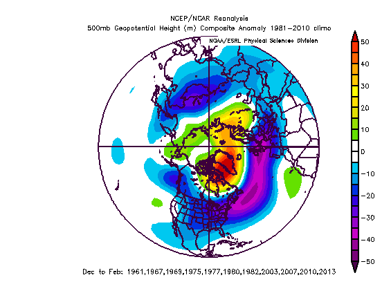
Isotherm wrote:Below is a 500mb composite of the 11 cases in which a < -0.75 October AO occurred, and their ensuing winters. 9/11 or 82% of those cases featured a -AO average for DJF. The glaring failures were 74-75 and 06-07 here. What's interesting is that this correlation does not really exist for > +0.75 AO Octobers as their ensuing winters featured mixed results. At this point in time, it's still early in the season, and generally when we examine -AO or +AO Octobers, there isn't much of a correlation when including the weakly positive or negative cases.
Good post.
Check out what the SST's are looking like in the Pacific.

The train of typhoons are impacting the SST's pretty tremendously in the western and northwest Pacific, hence the much below normal departures. I have a feeling once things settle down over there, Nino may try to get on a roll. Studying the SST pattern this Fall will be key to the winter outlook.
_________________
_______________________________________________________________________________________________________
CLICK HERE to view NJ Strong Snowstorm Classifications
Frank_Wx- Godzilla Seeker
- Posts : 21305
Reputation : 328
Join date : 2013-01-05
Age : 31
Location : Jersey City, NJ -
Re: Official Long Range Thread 3.0
![]() by skinsfan1177 Wed Oct 08, 2014 6:10 pm
by skinsfan1177 Wed Oct 08, 2014 6:10 pm
Frank_Wx wrote:Isotherm wrote:Below is a 500mb composite of the 11 cases in which a < -0.75 October AO occurred, and their ensuing winters. 9/11 or 82% of those cases featured a -AO average for DJF. The glaring failures were 74-75 and 06-07 here. What's interesting is that this correlation does not really exist for > +0.75 AO Octobers as their ensuing winters featured mixed results. At this point in time, it's still early in the season, and generally when we examine -AO or +AO Octobers, there isn't much of a correlation when including the weakly positive or negative cases.
Good post.
Check out what the SST's are looking like in the Pacific.
The train of typhoons are impacting the SST's pretty tremendously in the western and northwest Pacific, hence the much below normal departures. I have a feeling once things settle down over there, Nino may try to get on a roll. Studying the SST pattern this Fall will be key to the winter outlook.

skinsfan1177- Senior Enthusiast
- Posts : 4485
Reputation : 35
Join date : 2013-01-07
Age : 46
Location : Point Pleasant Boro
Re: Official Long Range Thread 3.0
![]() by jmanley32 Wed Oct 08, 2014 7:07 pm
by jmanley32 Wed Oct 08, 2014 7:07 pm
jmanley32- Senior Enthusiast
- Posts : 20516
Reputation : 108
Join date : 2013-12-12
Age : 42
Location : Yonkers, NY
Re: Official Long Range Thread 3.0
![]() by Frank_Wx Wed Oct 08, 2014 7:18 pm
by Frank_Wx Wed Oct 08, 2014 7:18 pm
_________________
_______________________________________________________________________________________________________
CLICK HERE to view NJ Strong Snowstorm Classifications
Frank_Wx- Godzilla Seeker
- Posts : 21305
Reputation : 328
Join date : 2013-01-05
Age : 31
Location : Jersey City, NJ -
Re: Official Long Range Thread 3.0
![]() by skinsfan1177 Wed Oct 08, 2014 8:49 pm
by skinsfan1177 Wed Oct 08, 2014 8:49 pm
skinsfan1177- Senior Enthusiast
- Posts : 4485
Reputation : 35
Join date : 2013-01-07
Age : 46
Location : Point Pleasant Boro
Re: Official Long Range Thread 3.0
![]() by Frank_Wx Wed Oct 08, 2014 9:12 pm
by Frank_Wx Wed Oct 08, 2014 9:12 pm
skinsfan1177 wrote:Can some one explain to me sst are and how they influence are upcoming upcoming winter.
SST = Sea Surface Temperatures
Recall last winter when the northern Pacific Ocean was experiencing SST's much above normal. What ended up occurring was a lot of ridging into Alaska (positive heights) which lead to frequent troughs (below heights) in the eastern U.S. I'm not sure how true this is, but I find there is a direct correlation to ridging above +SST's and troughs over -SST departures. So studying the SST pattern and trying to map out how it may look like this winter, including the ENSO, should give good insight as to how the overall 500 mb pattern will play out for the US.
_________________
_______________________________________________________________________________________________________
CLICK HERE to view NJ Strong Snowstorm Classifications
Frank_Wx- Godzilla Seeker
- Posts : 21305
Reputation : 328
Join date : 2013-01-05
Age : 31
Location : Jersey City, NJ -
Re: Official Long Range Thread 3.0
![]() by Quietace Wed Oct 08, 2014 9:26 pm
by Quietace Wed Oct 08, 2014 9:26 pm
That is not my point, sorry if i misspoke.jmanley32 wrote:I am aware Quietace, i do not think a Sandy 2 would be anybodys fantasy. Anythoughts on the second post which is much closer in time?
My point is that you posted a graphic that is 384 hours out. Which is in fantasy land itself. Most systems past truncation on the GFS especially 240+ hours hours out rarely verify if at all. Posting images that far out just adds hype to a system that will most likely not form and is not constructive IMO.

Quietace- Meteorologist - Mod

- Posts : 3687
Reputation : 33
Join date : 2013-01-07
Age : 27
Location : Point Pleasant, NJ
Re: Official Long Range Thread 3.0
![]() by nutleyblizzard Wed Oct 08, 2014 9:34 pm
by nutleyblizzard Wed Oct 08, 2014 9:34 pm
nutleyblizzard- Senior Enthusiast
- Posts : 1952
Reputation : 41
Join date : 2014-01-30
Age : 58
Location : Nutley, new jersey
Re: Official Long Range Thread 3.0
![]() by Frank_Wx Wed Oct 08, 2014 9:45 pm
by Frank_Wx Wed Oct 08, 2014 9:45 pm
nutleyblizzard wrote:Frank from the looks at the SST map, the northern pacific up towards Alaska look plenty warm, which would lock in troughiness for the east coast. What we obviously need for an active winter is the Atlantic to cooperate. If we can get a dominating -NAO this winter along with the +PNA, we'll be in business. On top of that, if the EL Nino develops, then the skys the limit.
Between now and December 1st (start of Meteorological winter) is still a good bit away. So these SST anomalies could change. But like I said before, once the tropics slow down in the Pacific things may become a little clearer. Hopefully the PDO does not revert back to negative, which I think will not happen since the PDO is usually cyclical.
_________________
_______________________________________________________________________________________________________
CLICK HERE to view NJ Strong Snowstorm Classifications
Frank_Wx- Godzilla Seeker
- Posts : 21305
Reputation : 328
Join date : 2013-01-05
Age : 31
Location : Jersey City, NJ -
Re: Official Long Range Thread 3.0
![]() by jmanley32 Wed Oct 08, 2014 10:14 pm
by jmanley32 Wed Oct 08, 2014 10:14 pm
And Frank yes I know there is alot more too it but you are way above me on understanding all that stuff and I do not have enough time to really learn it at this time. So I guess I will watch and see what you have to say, you seems to get things right more than wrong which is great.
jmanley32- Senior Enthusiast
- Posts : 20516
Reputation : 108
Join date : 2013-12-12
Age : 42
Location : Yonkers, NY
Re: Official Long Range Thread 3.0
![]() by Frank_Wx Wed Oct 08, 2014 10:48 pm
by Frank_Wx Wed Oct 08, 2014 10:48 pm


While the east remains mainly cool, the warm pool in the northern Pac. would be severely impacted if this were to be true.
_________________
_______________________________________________________________________________________________________
CLICK HERE to view NJ Strong Snowstorm Classifications
Frank_Wx- Godzilla Seeker
- Posts : 21305
Reputation : 328
Join date : 2013-01-05
Age : 31
Location : Jersey City, NJ -
Re: Official Long Range Thread 3.0
![]() by jmanley32 Wed Oct 08, 2014 11:03 pm
by jmanley32 Wed Oct 08, 2014 11:03 pm
jmanley32- Senior Enthusiast
- Posts : 20516
Reputation : 108
Join date : 2013-12-12
Age : 42
Location : Yonkers, NY
Re: Official Long Range Thread 3.0
![]() by Frank_Wx Wed Oct 08, 2014 11:09 pm
by Frank_Wx Wed Oct 08, 2014 11:09 pm

That is the area last winter that had above normal sea surface temps which contributed to the persistent -EPO/+TNA pattern, which obviously brought us all that cold and snow. If it dissipates, and the ENSO never gets going, that could be a worst-case scenario for people looking for a repeat of last winter. But still too early. It is possible this trough does not impact the SST's as much, but I will be curious to see.
_________________
_______________________________________________________________________________________________________
CLICK HERE to view NJ Strong Snowstorm Classifications
Frank_Wx- Godzilla Seeker
- Posts : 21305
Reputation : 328
Join date : 2013-01-05
Age : 31
Location : Jersey City, NJ -
Re: Official Long Range Thread 3.0
![]() by Math23x7 Thu Oct 09, 2014 12:06 am
by Math23x7 Thu Oct 09, 2014 12:06 am
Math23x7- Wx Statistician Guru

- Posts : 2379
Reputation : 68
Join date : 2013-01-08
Re: Official Long Range Thread 3.0
![]() by sroc4 Thu Oct 09, 2014 8:31 am
by sroc4 Thu Oct 09, 2014 8:31 am
Frank_Wx wrote:nutleyblizzard wrote:Frank from the looks at the SST map, the northern pacific up towards Alaska look plenty warm, which would lock in troughiness for the east coast. What we obviously need for an active winter is the Atlantic to cooperate. If we can get a dominating -NAO this winter along with the +PNA, we'll be in business. On top of that, if the EL Nino develops, then the skys the limit.
Between now and December 1st (start of Meteorological winter) is still a good bit away. So these SST anomalies could change. But like I said before, once the tropics slow down in the Pacific things may become a little clearer. Hopefully the PDO does not revert back to negative, which I think will not happen since the PDO is usually cyclical.
Frank this is a great point! I have been watching the SST in both the Atlantic and Pacific since last Jan; saving images every 4 months or so. Notice how large the SST anomalies were last Jan. in the NE Pac. and compare them with now. The area has shrunk drastically and the warm anomalies have crept down the NW coast, particularly the area between Hawaii and the Western CONUS. Also the anomalies in the Beiring sea have warmed significantly since Jan. They are similar in intensity compared to the area in the GOA whereas last Jan they were cooler relatively speaking. Will this affect the ability for the trough set up over the Aleutians which aided in the amplification of the ridge over the west coast all of last winter? Look at that finger of cool anomalies infiltrating from the west. This has been by and large the basic track for all of the major tropical cyclones that have re-curved during this tropical season. I am worried that the NE Pac is trying to flip. Maybe not in time for this winter, but possibly by the summer of next year.
Jan 19th 2014:
 " />
" />April 27 2014:
 " />
" />SEPT 30th 2014:
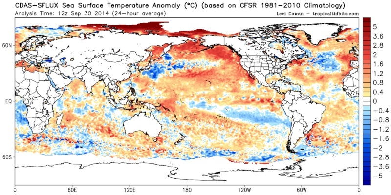 " />
" />Also notice the Atlantic SST anomalies. The area to me that stands out the most is the anomaly off the coast of Western Europe. Last Jan was cold anomalies. Currently a warm pool has developed. Will this affect the down stream setup this year?? What I don't have are the Atlantic anomalies for this time frame from last year. I don't know much about how quickly this area can flip based on the depth of water etc. Anyway def stuff to watch. I agree once the Tropical Pac calms down we can see how the El Nino or lack thereof sets up and if the influences of the warm anomalies in the NE Pac on the EPO and PNA will be as pronounced as they were last winter. Of course we can't forget about how the stratospheric warming anomalies, particularly where they set up, will affect the overall pattern.
Jan 19th 2014:
 " />
" />April 27th 2014:
 " />
" />Sept 30th 2014:
 " />
" />Side note: Typhoon Vongfong is forecasted to recurve over the next 3-5days and should still lead to a trough in the east towards the end of the month. We will prob lock into more of a normal to colder than avg pattern going into November.
_________________
"In weather and in life, there's no winning and losing; there's only winning and learning."
WINTER 2012/2013 TOTALS 43.65"WINTER 2017/2018 TOTALS 62.85" WINTER 2022/2023 TOTALS 4.9"
WINTER 2013/2014 TOTALS 64.85"WINTER 2018/2019 TOTALS 14.25" WINTER 2023/2024 TOTALS 13.1"
WINTER 2014/2015 TOTALS 71.20"WINTER 2019/2020 TOTALS 6.35"
WINTER 2015/2016 TOTALS 35.00"WINTER 2020/2021 TOTALS 37.75"
WINTER 2016/2017 TOTALS 42.25"WINTER 2021/2022 TOTALS 31.65"

sroc4- Admin
- Posts : 8331
Reputation : 301
Join date : 2013-01-07
Location : Wading River, LI
Re: Official Long Range Thread 3.0
![]() by amugs Thu Oct 09, 2014 9:37 am
by amugs Thu Oct 09, 2014 9:37 am
For teh rest of us - what does this look like on the euro 7 days out ??

_________________
Mugs
AKA:King: Snow Weenie
Self Proclaimed
WINTER 2014-15 : 55.12" +.02 for 6 coatings (avg. 35")
WINTER 2015-16 Total - 29.8" (Avg 35")
WINTER 2016-17 : 39.5" so far

amugs- Advanced Forecaster - Mod

- Posts : 15093
Reputation : 213
Join date : 2013-01-07
Age : 54
Location : Hillsdale,NJ
Re: Official Long Range Thread 3.0
![]() by amugs Thu Oct 09, 2014 10:46 am
by amugs Thu Oct 09, 2014 10:46 am

For you JMAN!!
_________________
Mugs
AKA:King: Snow Weenie
Self Proclaimed
WINTER 2014-15 : 55.12" +.02 for 6 coatings (avg. 35")
WINTER 2015-16 Total - 29.8" (Avg 35")
WINTER 2016-17 : 39.5" so far
amugs- Advanced Forecaster - Mod
- Posts : 15093
Reputation : 213
Join date : 2013-01-07
Age : 54
Location : Hillsdale,NJ
Page 20 of 32 • 1 ... 11 ... 19, 20, 21 ... 26 ... 32 ![]()
|
|
|