
 Search
Official Long Range Thread 3.0
Page 26 of 32 •  1 ... 14 ... 25, 26, 27 ... 32
 ![]()
Re: Official Long Range Thread 3.0
![]() by sroc4 Sat Oct 18, 2014 8:53 am
by sroc4 Sat Oct 18, 2014 8:53 am
I think
sroc4- Admin

- Posts : 8331
Join date : 2013-01-07
Re: Official Long Range Thread 3.0
![]() by Frank_Wx Sat Oct 18, 2014 10:24 am
by Frank_Wx Sat Oct 18, 2014 10:24 am
Frank_Wx- Godzilla Seeker
- Posts : 21305
Join date : 2013-01-05 -

Re: Official Long Range Thread 3.0
![]() by Frank_Wx Sat Oct 18, 2014 10:30 am
by Frank_Wx Sat Oct 18, 2014 10:30 am
_________________
_______________________________________________________________________________________________________
CLICK HERE to view NJ Strong Snowstorm Classifications

Frank_Wx- Godzilla Seeker
- Posts : 21305
Reputation : 328
Join date : 2013-01-05
Age : 31
Location : Jersey City, NJ -
Re: Official Long Range Thread 3.0
![]() by Frank_Wx Sat Oct 18, 2014 10:35 am
by Frank_Wx Sat Oct 18, 2014 10:35 am

So if what I said about the phase comes true, even though I do not believe it will happen, the rain totals you see in New England would be a possibility for NYC as well. As of now though, this looks like a nuisance storm bringing 1-2 inches of rain over a 3-4 day period. Which is very much doable for us.
Edit: it may also be 1-2 inches is too high. I can definitely see how western and southern areas see far less compared to northern areas.
_________________
_______________________________________________________________________________________________________
CLICK HERE to view NJ Strong Snowstorm Classifications
Frank_Wx- Godzilla Seeker
- Posts : 21305
Reputation : 328
Join date : 2013-01-05
Age : 31
Location : Jersey City, NJ -
Re: Official Long Range Thread 3.0
![]() by sroc4 Sat Oct 18, 2014 12:14 pm
by sroc4 Sat Oct 18, 2014 12:14 pm
Frank_Wx wrote:I think what it boils down to is all this H5 vorticity trying to consolidate at the base of the trough and developing a potent storm. Anytime you have a rolling ridge in the west it becomes difficult for those s/w energies phase because of the zonal nature of the pattern. Will there be a coastal storm? Probably. But there's not a piece of guidance that shows it bringing high impact to our area. The most bullish model is the EURO OP so far, with about 1-2 inches of rain and some wind. But we'll see how this weekend trends
I think you and I are looking at the same box from slightly different perspectives. This point was the one I was trying to make in my original comments a day or two ago. That is that how all that energy behaves associated with the ULL and if any of it can consolidate will affect totals. I agree 100% however, that this will most likely be nothing to write home about for our area. A general 0.5-2.5" totals over the entire period Lower totals S and west and higher N and east. I still think if the soln leans closer to the Euro soln where we get stronger vorticity with some vertical stacking of the atmosphere areas like the CT coast up through S Maine could see significant rain totals with flooding as I outlined above. And areas like eastern half of LI could end up a tick higher like 2-4" total from Tuesday through Friday ish as well. The 12 Z GFS is coming in with a more amplified H5 appearance, but IMO the surface doesnt not match H5. I could be wrong of course. Ill wait to see the Euro and CMC before I say much more.
_________________
"In weather and in life, there's no winning and losing; there's only winning and learning."
WINTER 2012/2013 TOTALS 43.65"WINTER 2017/2018 TOTALS 62.85" WINTER 2022/2023 TOTALS 4.9"
WINTER 2013/2014 TOTALS 64.85"WINTER 2018/2019 TOTALS 14.25" WINTER 2023/2024 TOTALS 13.1"
WINTER 2014/2015 TOTALS 71.20"WINTER 2019/2020 TOTALS 6.35"
WINTER 2015/2016 TOTALS 35.00"WINTER 2020/2021 TOTALS 37.75"
WINTER 2016/2017 TOTALS 42.25"WINTER 2021/2022 TOTALS 31.65"

sroc4- Admin
- Posts : 8331
Reputation : 301
Join date : 2013-01-07
Location : Wading River, LI
Re: Official Long Range Thread 3.0
![]() by jmanley32 Sat Oct 18, 2014 4:16 pm
by jmanley32 Sat Oct 18, 2014 4:16 pm

jmanley32- Senior Enthusiast

- Posts : 20517
Reputation : 108
Join date : 2013-12-12
Age : 42
Location : Yonkers, NY
Re: Official Long Range Thread 3.0
![]() by NjWeatherGuy Sat Oct 18, 2014 5:25 pm
by NjWeatherGuy Sat Oct 18, 2014 5:25 pm

NjWeatherGuy- Advanced Forecaster

- Posts : 4100
Reputation : 28
Join date : 2013-01-06
Location : Belle Mead, NJ
Re: Official Long Range Thread 3.0
![]() by sroc4 Sat Oct 18, 2014 5:41 pm
by sroc4 Sat Oct 18, 2014 5:41 pm
NjWeatherGuy wrote:GFS has this storm stalling off the coast of NJ before heading NE meanwhile the EURO is much further to the north and east stalling it off the coast of Maine but overall has the evolution moving faster compared to the GFS. Hopefully the EURO is more correct I don't want this sitting off NJ spewing rain showers on and off for several days.
What's up Tom. Welcome Back.
_________________
"In weather and in life, there's no winning and losing; there's only winning and learning."
WINTER 2012/2013 TOTALS 43.65"WINTER 2017/2018 TOTALS 62.85" WINTER 2022/2023 TOTALS 4.9"
WINTER 2013/2014 TOTALS 64.85"WINTER 2018/2019 TOTALS 14.25" WINTER 2023/2024 TOTALS 13.1"
WINTER 2014/2015 TOTALS 71.20"WINTER 2019/2020 TOTALS 6.35"
WINTER 2015/2016 TOTALS 35.00"WINTER 2020/2021 TOTALS 37.75"
WINTER 2016/2017 TOTALS 42.25"WINTER 2021/2022 TOTALS 31.65"
sroc4- Admin
- Posts : 8331
Reputation : 301
Join date : 2013-01-07
Location : Wading River, LI
Re: Official Long Range Thread 3.0
![]() by jmanley32 Sat Oct 18, 2014 5:42 pm
by jmanley32 Sat Oct 18, 2014 5:42 pm
jmanley32- Senior Enthusiast
- Posts : 20517
Reputation : 108
Join date : 2013-12-12
Age : 42
Location : Yonkers, NY
Re: Official Long Range Thread 3.0
![]() by NjWeatherGuy Sat Oct 18, 2014 5:49 pm
by NjWeatherGuy Sat Oct 18, 2014 5:49 pm
sroc4 wrote:NjWeatherGuy wrote:GFS has this storm stalling off the coast of NJ before heading NE meanwhile the EURO is much further to the north and east stalling it off the coast of Maine but overall has the evolution moving faster compared to the GFS. Hopefully the EURO is more correct I don't want this sitting off NJ spewing rain showers on and off for several days.
What's up Tom. Welcome Back.
Yeah I've been on and off for a while, nothing really exciting has happened thus far but it looks like we'll go below freezing tomorrow night so that's showing the transition to winter, it's definitely getting cooler overall.
NjWeatherGuy- Advanced Forecaster
- Posts : 4100
Reputation : 28
Join date : 2013-01-06
Location : Belle Mead, NJ
Re: Official Long Range Thread 3.0
![]() by Frank_Wx Sat Oct 18, 2014 11:54 pm
by Frank_Wx Sat Oct 18, 2014 11:54 pm
_________________
_______________________________________________________________________________________________________
CLICK HERE to view NJ Strong Snowstorm Classifications
Frank_Wx- Godzilla Seeker
- Posts : 21305
Reputation : 328
Join date : 2013-01-05
Age : 31
Location : Jersey City, NJ -
Re: Official Long Range Thread 3.0
![]() by sroc4 Sun Oct 19, 2014 6:57 am
by sroc4 Sun Oct 19, 2014 6:57 am
Frank_Wx wrote:The GFS and EURO runs today confirmed my thoughts that the bulk of the rain will fall in New England. It's even trended weaker, not getting below 1000mb and remaining relatively broad in nature. Not impressed.
Agreed. I started a new thread so this one can go back to the long range discussion.
_________________
"In weather and in life, there's no winning and losing; there's only winning and learning."
WINTER 2012/2013 TOTALS 43.65"WINTER 2017/2018 TOTALS 62.85" WINTER 2022/2023 TOTALS 4.9"
WINTER 2013/2014 TOTALS 64.85"WINTER 2018/2019 TOTALS 14.25" WINTER 2023/2024 TOTALS 13.1"
WINTER 2014/2015 TOTALS 71.20"WINTER 2019/2020 TOTALS 6.35"
WINTER 2015/2016 TOTALS 35.00"WINTER 2020/2021 TOTALS 37.75"
WINTER 2016/2017 TOTALS 42.25"WINTER 2021/2022 TOTALS 31.65"
sroc4- Admin
- Posts : 8331
Reputation : 301
Join date : 2013-01-07
Location : Wading River, LI
Re: Official Long Range Thread 3.0
![]() by Frank_Wx Sun Oct 19, 2014 10:03 am
by Frank_Wx Sun Oct 19, 2014 10:03 am

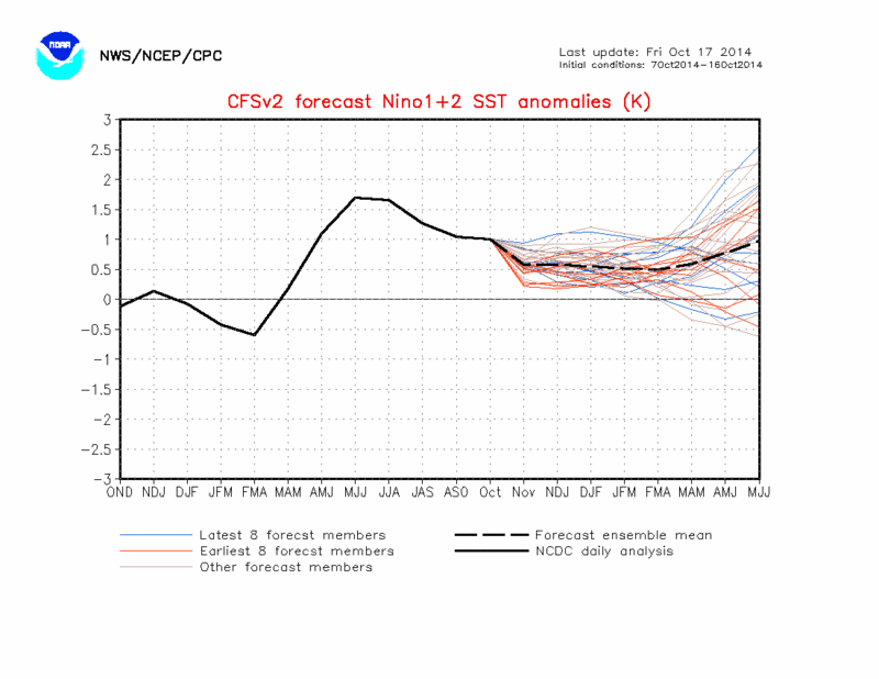
Sea surface temps this morning in the ENSO and PDO regions look great. I think I can safely say El Nino is starting to come together, slowly but surely, which means the sub tropical jet stream over the winter could be a big player for some big storms. Let's just hope the cold temps are there to accompany it
_________________
_______________________________________________________________________________________________________
CLICK HERE to view NJ Strong Snowstorm Classifications
Frank_Wx- Godzilla Seeker
- Posts : 21305
Reputation : 328
Join date : 2013-01-05
Age : 31
Location : Jersey City, NJ -
Re: Official Long Range Thread 3.0
![]() by amugs Sun Oct 19, 2014 12:36 pm
by amugs Sun Oct 19, 2014 12:36 pm
Frank_Wx wrote:
Sea surface temps this morning in the ENSO and PDO regions look great. I think I can safely say El Nino is starting to come together, slowly but surely, which means the sub tropical jet stream over the winter could be a big player for some big storms. Let's just hope the cold temps are there to accompany it
This is wonderful news to get thes etwo players on teh table - could be a 1977-78 or 2003-04, 2009-10 type winter that had similar set ups - the eurasia snow growth and canadian snow growth is comingto gether as well for us - need the AO and NAO to cooperate and BAM we shoudl be having soem fun an dall nighter thiese next few months - or at least I am praying for
Or else I lose my self appointed crown as King Snow Weenie!
Okay does anyone recall JB saying after the 2009-10 winter that the next 3 out of 5 winters would be cold and snowy - people laughed in 2010-11 as we torched but for the most part I know he is hype artist with storms but he is close to being spot on - I have to try and dig up that article
_________________
Mugs
AKA:King: Snow Weenie
Self Proclaimed
WINTER 2014-15 : 55.12" +.02 for 6 coatings (avg. 35")
WINTER 2015-16 Total - 29.8" (Avg 35")
WINTER 2016-17 : 39.5" so far

amugs- Advanced Forecaster - Mod

- Posts : 15093
Reputation : 213
Join date : 2013-01-07
Age : 54
Location : Hillsdale,NJ
Re: Official Long Range Thread 3.0
![]() by jmanley32 Sun Oct 19, 2014 12:49 pm
by jmanley32 Sun Oct 19, 2014 12:49 pm
jmanley32- Senior Enthusiast
- Posts : 20517
Reputation : 108
Join date : 2013-12-12
Age : 42
Location : Yonkers, NY
Re: Official Long Range Thread 3.0
![]() by Isotherm Sun Oct 19, 2014 7:51 pm
by Isotherm Sun Oct 19, 2014 7:51 pm
Frank_Wx wrote:Isotherm wrote:There are certain patterns that you "want" to see in November in terms of foretelling an ensuing favorable pattern for DJF, but there are quite a few cases in which November's pattern falls in the unfavorable category, yet the DJF periods still turned out good. In those cases, generally < 35% of the time, one will see the regime beginning to transition toward the end of November into early December. 2009 is a good example of this. Other cases in which the November pattern was generally unfavorable, but improved for the winter:
2003-04
2009-10
1979-80
1986-87
1977-78
These aren't all of them, but some of the notable scenarios. One should notice that the majority of these years were either El Nino or warm neutral patterns, and that is not a coincidence. El Nino atmospheric regimes are sometimes delayed in the development of tropospheric blocking.
There's a healthy westerly wind bursting progged to occur w/ solid -SOI over the next week-10 days, which should warm the western ENSO regions. Most data I've seen suggests a 3.4 based event, possibly region 4, while regions 1+2 are progged to be the coolest.
So right now I'm far from concerned about the winter. The first half of November, while I'd "like" to see a certain pattern, it's less important than the progression that occurs in the second half of November into early December.
Tom so what you're saying is we could be in a transition period where the upper level pattern is transitioning from neutral ENSO to +ENSO. This makes sense since the analogs you mention happen to be +ENSO years, so I do not think it is a coincidence those years features above normal temps. in the Fall.

Yeah I don't think we can necessarily draw any conclusions about the ensuing winter from the coming 2-3 weeks. With that being said, what we certainly don't want to see in November is the appearance of a Bering Sea / AK vortex, as that spells ultimate doom -- see 2011, 2006, early 1990s, etc.
Right now, I'm reasonably satisfied with the progression of October parameters, though I would have preferred to see a dominant +NAO in conjunction with the -AO / Aleutian trough. Nevertheless, can't have our cake and eat it too.
The snow cover advance in the northern hemisphere has been pretty impressive to date. Will be interesting to see the final SAI/SCE numbers.
I'd say the variable I'm most uncertain about right now is the NAO, which also happens to be one of the more important winter indices for our area.
In other news, solar activity has decreased over the past week. We'll see whether that continues for November.
Isotherm- Advanced Forecaster
- Posts : 231
Reputation : 4
Join date : 2014-09-01
Age : 33
Location : Monmouth County, NJ -
Re: Official Long Range Thread 3.0
![]() by Isotherm Sun Oct 19, 2014 7:55 pm
by Isotherm Sun Oct 19, 2014 7:55 pm
amugs wrote:nutleyblizzard wrote:As long as we have seasonable (normal) cold temps this winter, we'll be just fine. You don't want that polar vortex too far south anyway… remember last winter folks. Even though we had above normal snow amounts, there were also many times that the intense cold air squashed potential snowstorms to the south of us. With the EL Nino looking like its finally rounding into shape, we should have plenty of storm potentials. Unlike last year when we had snow down to the coast, I feel this winter we will have mixing issues along the coast at times, but we'll see.
Nuts,
Totally agree with you and the ENSO starting to warm up (region3.4)is a good sign as well as the GOA - I think it turns after all the upwelling from all those typhoons that recurved up into that region quells. We have time and Tom (Isotherm- btw he is a great and I mean great met and thanks for joining this board) has said it perfectly - the transition period - end of Nov into mid Dec will tell us to a certain degree where we will be at for winter and the years he has mentioned all had a warm fall and then flipped - 79-80 sucked snowfall wise but was cold - I'll take 2009-10, 1977-78 and 203-04 any day of the week and would out my house up for those winters.
If I were in NE with the EURO weeklies I start to get pissed because NOv starts winter for those folks - not CT coastal but up in the NW parts.
The coast should mix this winter if all goes according to climo - talk about an anomaly the past number of years - as a kid in the 70's and 80's they always had a mix to rain in most of these storms just like the climo shows but as of recent times they have been the jackpot. Maybe the pendulum will swing back this way. Normal cold is fine - the PV did a number on all of the storms from Feb 18 until March 22 if you recall - 6 storms and SNJ (forget them) jackpotted big time - as did DE and MD. We have time and Mother Nature will do her job - whatever that may be.
DT releases his official winter forecast this weekend - I think Sunday - way to early IMO - I like mid to late November - usually Tday for it because then you really start to see what is what.
Looks like the Euro OP and Ensembles are in two different states - time will tell still 4 days away. Anyway wet and cool, chilly next week - my grass and the reservoirs could use a good light to moderate rain - be careful what I wish for I know.
Thanks mugs! Glad to be here with everyone. I agree w/ your points. I think it's foolhardy to release a winter forecast prior to November 15th, but if someone can do it and do it well, then more power to you. For me, I feel much more comfortable waiting until the third week or so of November and that's what I plan to do this year as per usual. Might as well get as much fall data as you can to increase the probability of an accurate LR call.
Isotherm- Advanced Forecaster
- Posts : 231
Reputation : 4
Join date : 2014-09-01
Age : 33
Location : Monmouth County, NJ -
Re: Official Long Range Thread 3.0
![]() by amugs Tue Oct 21, 2014 1:14 pm
by amugs Tue Oct 21, 2014 1:14 pm

_________________
Mugs
AKA:King: Snow Weenie
Self Proclaimed
WINTER 2014-15 : 55.12" +.02 for 6 coatings (avg. 35")
WINTER 2015-16 Total - 29.8" (Avg 35")
WINTER 2016-17 : 39.5" so far
amugs- Advanced Forecaster - Mod
- Posts : 15093
Reputation : 213
Join date : 2013-01-07
Age : 54
Location : Hillsdale,NJ
Re: Official Long Range Thread 3.0
![]() by Isotherm Tue Oct 21, 2014 3:14 pm
by Isotherm Tue Oct 21, 2014 3:14 pm
Making progress folks.
http://www.bom.gov.a...ookmark=nino3.4
Daily SOI of -25 and 90 day running average now down to -8. We're undoubtedly in Nino territory. October will be the 4th consecutive -SOI month, and given statistics, that's a nearly 100% indicator of an ensuing El Nino event.
https://www.longpadd...cillationindex/
Isotherm- Advanced Forecaster
- Posts : 231
Reputation : 4
Join date : 2014-09-01
Age : 33
Location : Monmouth County, NJ -
Re: Official Long Range Thread 3.0
![]() by Isotherm Tue Oct 21, 2014 3:18 pm
by Isotherm Tue Oct 21, 2014 3:18 pm
Isotherm- Advanced Forecaster
- Posts : 231
Reputation : 4
Join date : 2014-09-01
Age : 33
Location : Monmouth County, NJ -
Re: Official Long Range Thread 3.0
![]() by jmanley32 Tue Oct 21, 2014 3:27 pm
by jmanley32 Tue Oct 21, 2014 3:27 pm
jmanley32- Senior Enthusiast
- Posts : 20517
Reputation : 108
Join date : 2013-12-12
Age : 42
Location : Yonkers, NY
Re: Official Long Range Thread 3.0
![]() by jmanley32 Tue Oct 21, 2014 3:28 pm
by jmanley32 Tue Oct 21, 2014 3:28 pm
jmanley32- Senior Enthusiast
- Posts : 20517
Reputation : 108
Join date : 2013-12-12
Age : 42
Location : Yonkers, NY
Re: Official Long Range Thread 3.0
![]() by algae888 Tue Oct 21, 2014 3:53 pm
by algae888 Tue Oct 21, 2014 3:53 pm

algae888- Advanced Forecaster
- Posts : 5311
Reputation : 46
Join date : 2013-02-05
Age : 61
Location : mt. vernon, new york
Re: Official Long Range Thread 3.0
![]() by algae888 Tue Oct 21, 2014 5:43 pm
by algae888 Tue Oct 21, 2014 5:43 pm
algae888- Advanced Forecaster
- Posts : 5311
Reputation : 46
Join date : 2013-02-05
Age : 61
Location : mt. vernon, new york
Re: Official Long Range Thread 3.0
![]() by jmanley32 Tue Oct 21, 2014 5:53 pm
by jmanley32 Tue Oct 21, 2014 5:53 pm
jmanley32- Senior Enthusiast
- Posts : 20517
Reputation : 108
Join date : 2013-12-12
Age : 42
Location : Yonkers, NY
Re: Official Long Range Thread 3.0
![]() by algae888 Tue Oct 21, 2014 6:48 pm
by algae888 Tue Oct 21, 2014 6:48 pm
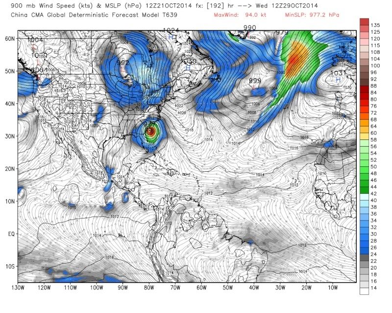
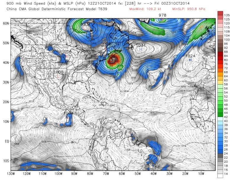
My bad jman but I don't think anybody on here takes any model seriously 200 hours +.jmanley32 wrote:Al that's not the cmc it's the cma the Chinese moxel. I've never seen anyone post it.
algae888- Advanced Forecaster
- Posts : 5311
Reputation : 46
Join date : 2013-02-05
Age : 61
Location : mt. vernon, new york
Re: Official Long Range Thread 3.0
![]() by jmanley32 Tue Oct 21, 2014 6:50 pm
by jmanley32 Tue Oct 21, 2014 6:50 pm
jmanley32- Senior Enthusiast
- Posts : 20517
Reputation : 108
Join date : 2013-12-12
Age : 42
Location : Yonkers, NY
Page 26 of 32 • 1 ... 14 ... 25, 26, 27 ... 32 ![]()
|
|
|