
 Search
Official Long Range Thread 3.0
Page 25 of 32 •  1 ... 14 ... 24, 25, 26 ... 28 ... 32
 ![]()
Re: Official Long Range Thread 3.0
![]() by jmanley32 Fri Oct 17, 2014 12:34 pm
by jmanley32 Fri Oct 17, 2014 12:34 pm
jmanley32- Senior Enthusiast

- Posts : 20516
Join date : 2013-12-12
Re: Official Long Range Thread 3.0
![]() by Frank_Wx Fri Oct 17, 2014 12:36 pm
by Frank_Wx Fri Oct 17, 2014 12:36 pm
The EURO Weeklies suggest the end of this month into the 1st half of November is going to feature above normal temps. When I create a winter outlook, I look back at what the Meteorological Fall upper level pattern featured and see if any of those characteristics could carry over into the winter. So far, I am not impressed. Though there are some positives, which include NH Snow Cover and Pacific SST's, that outweigh the Oct/Nov H5 anomalies. So all of this is taken into consideration. It is not so early anymore. November will be here before we know it.
Here are the EURO Weeklies, which by the way, I am not taking seriously until other guidances' hop on board.
Week of Oct. 27th:

Week of Nov. 2nd:

Week of Nov. 9th:

Frank_Wx- Godzilla Seeker

- Posts : 21305
Join date : 2013-01-05 -

Re: Official Long Range Thread 3.0
![]() by amugs Fri Oct 17, 2014 1:01 pm
by amugs Fri Oct 17, 2014 1:01 pm
_________________
Mugs
AKA:King: Snow Weenie
Self Proclaimed
WINTER 2014-15 : 55.12" +.02 for 6 coatings (avg. 35")
WINTER 2015-16 Total - 29.8" (Avg 35")
WINTER 2016-17 : 39.5" so far

amugs- Advanced Forecaster - Mod

- Posts : 15093
Reputation : 213
Join date : 2013-01-07
Age : 54
Location : Hillsdale,NJ
Re: Official Long Range Thread 3.0
![]() by jmanley32 Fri Oct 17, 2014 1:08 pm
by jmanley32 Fri Oct 17, 2014 1:08 pm

jmanley32- Senior Enthusiast
- Posts : 20516
Reputation : 108
Join date : 2013-12-12
Age : 42
Location : Yonkers, NY
Re: Official Long Range Thread 3.0
![]() by jmanley32 Fri Oct 17, 2014 1:20 pm
by jmanley32 Fri Oct 17, 2014 1:20 pm

Last edited by jmanley32 on Fri Oct 17, 2014 1:21 pm; edited 1 time in total
jmanley32- Senior Enthusiast
- Posts : 20516
Reputation : 108
Join date : 2013-12-12
Age : 42
Location : Yonkers, NY
Re: Official Long Range Thread 3.0
![]() by Frank_Wx Fri Oct 17, 2014 1:21 pm
by Frank_Wx Fri Oct 17, 2014 1:21 pm
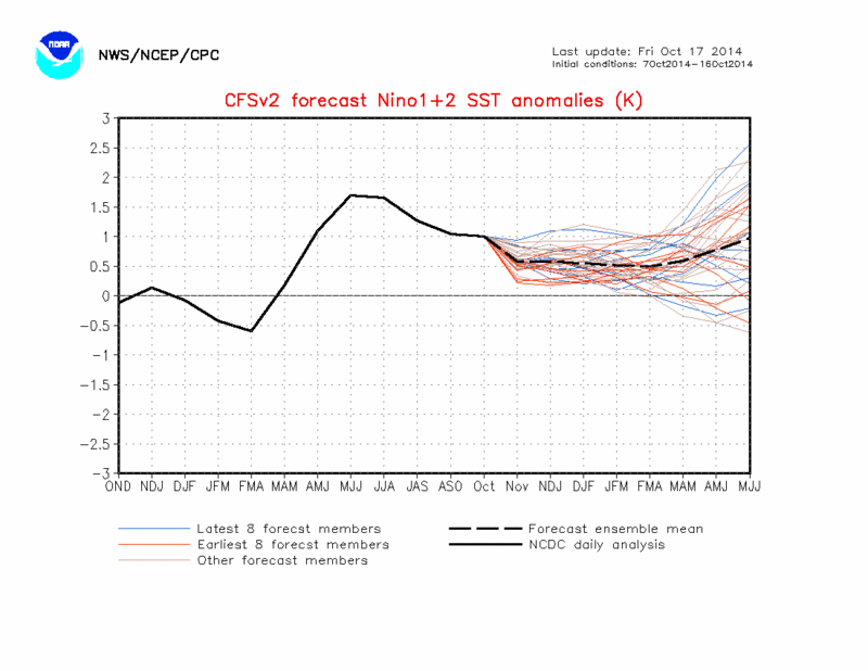
For the first time this season, all the Nino regions have reached the +0.5C plateau (the temp. threshold that classifies El Nino). Now it is just a matter of them sustaining and continuing to warm for El Nino to officially take off at the start of the winter. You can see how Nino region 3.4 warmed up nicely between October 11th and now.

Noteworthy also is the PDO region which looks quite warm. El Nino episodes usually equate to +PDO regimes as well. I will go over that in the winter outlook. The EPO region which was a crucial part of our winter pattern last winter is not quite as defined, but it has time to rebound once the typhoon season settles down which is causing upwelling.

_________________
_______________________________________________________________________________________________________
CLICK HERE to view NJ Strong Snowstorm Classifications

Frank_Wx- Godzilla Seeker
- Posts : 21305
Reputation : 328
Join date : 2013-01-05
Age : 31
Location : Jersey City, NJ -
Re: Official Long Range Thread 3.0
![]() by Frank_Wx Fri Oct 17, 2014 1:31 pm
by Frank_Wx Fri Oct 17, 2014 1:31 pm

_________________
_______________________________________________________________________________________________________
CLICK HERE to view NJ Strong Snowstorm Classifications
Frank_Wx- Godzilla Seeker
- Posts : 21305
Reputation : 328
Join date : 2013-01-05
Age : 31
Location : Jersey City, NJ -
Re: Official Long Range Thread 3.0
![]() by jmanley32 Fri Oct 17, 2014 1:35 pm
by jmanley32 Fri Oct 17, 2014 1:35 pm
jmanley32- Senior Enthusiast
- Posts : 20516
Reputation : 108
Join date : 2013-12-12
Age : 42
Location : Yonkers, NY
Re: Official Long Range Thread 3.0
![]() by algae888 Fri Oct 17, 2014 1:37 pm
by algae888 Fri Oct 17, 2014 1:37 pm

algae888- Advanced Forecaster

- Posts : 5311
Reputation : 46
Join date : 2013-02-05
Age : 61
Location : mt. vernon, new york
Re: Official Long Range Thread 3.0
![]() by Frank_Wx Fri Oct 17, 2014 1:41 pm
by Frank_Wx Fri Oct 17, 2014 1:41 pm
algae888 wrote:Frank last October average 3 degrees above normal followed by a below normal November and a little above normal December. then we went into the icebox. I really doubt we will see the cold we saw last year however we do not need it to be that cold to have a good winter. we just need it to be active with storms forming in the right place and at the right time. this winter's pattern looks totally different than last years. specifically what you said that we should have a positive PDO and the high snow cover in North America and Siberia and more than likely a weak el nino. I think the key to this winter as others have said on here is the NAO. last year as we know it was positive for most of the winter but my gut is telling me it's going to be negative this year with fluctuations of course. it will be interesting how this all sets up. looking forward to your outlook. by the way Stevie D outlook comes out on Sunday but I have a feeling he's going to call for a cold and snowy winter in the Northeast which I'm not sold on yet.
Absolutely right Al. Last winter cold temps. were the least of our worries. Cold was around all the time. We just needed the storms. This time around, I think we might have to worry about the cold temps. but not so much about the storms. Reversed. But we'll see.
_________________
_______________________________________________________________________________________________________
CLICK HERE to view NJ Strong Snowstorm Classifications
Frank_Wx- Godzilla Seeker
- Posts : 21305
Reputation : 328
Join date : 2013-01-05
Age : 31
Location : Jersey City, NJ -
Re: Official Long Range Thread 3.0
![]() by nutleyblizzard Fri Oct 17, 2014 3:11 pm
by nutleyblizzard Fri Oct 17, 2014 3:11 pm

nutleyblizzard- Senior Enthusiast
- Posts : 1952
Reputation : 41
Join date : 2014-01-30
Age : 58
Location : Nutley, new jersey
Re: Official Long Range Thread 3.0
![]() by skinsfan1177 Fri Oct 17, 2014 3:28 pm
by skinsfan1177 Fri Oct 17, 2014 3:28 pm

skinsfan1177- Senior Enthusiast
- Posts : 4485
Reputation : 35
Join date : 2013-01-07
Age : 46
Location : Point Pleasant Boro
Re: Official Long Range Thread 3.0
![]() by sroc4 Fri Oct 17, 2014 3:38 pm
by sroc4 Fri Oct 17, 2014 3:38 pm
Frank_Wx wrote:The 12z GGEM, the most bullish model for a coastal storm, has a double barrel low idea which kind of looks like convective feedback to me. First off, as you can see from the graphic, it really digs the H5 energy into the trough (#2) and then phases it with another piece from the Great Lakes (#1). A coastal storm spawns off the coast. That is the way this should develop, not two sub 1000mb lows off the coast.
I dont know Frank. What so far seems to be consistent is that instead of just having one strong focal vort max as that piece that dives in from the GL and phases with the digging trough triggering a strong surface LP, it instead causes H5 to close off into a huge ULL. As a result the vorticity seems to get all strung out within it instead of remaining consolidated. I think the models are having a hard time placing the position and intensity of the LP on the surface because of that. What I can see poss playing out is initially a surface LP develops as the energy phases, but once H5 closes off the surface LP never intensifies, and actually trys to jump around depending on where the strongest vorticity occurs. Underneath the center of the broad ULL its going to be hard to get a whole lot of significant convection, but rather the main convection stays well offshore, and enhances precip well up into NE ie: NE Ct, Mass and Maine. If the ULL closes off as large as has been recently modeled I cant see how it will develop one strong consolidated surface LP at all, nor two sub 1000mb LP like the CMC, but I can see where multiple areas of weak LP centers try to develop but never get going in response to the strung out vorticity embeded with the H5 ULL.
_________________
"In weather and in life, there's no winning and losing; there's only winning and learning."
WINTER 2012/2013 TOTALS 43.65"WINTER 2017/2018 TOTALS 62.85" WINTER 2022/2023 TOTALS 4.9"
WINTER 2013/2014 TOTALS 64.85"WINTER 2018/2019 TOTALS 14.25" WINTER 2023/2024 TOTALS 13.1"
WINTER 2014/2015 TOTALS 71.20"WINTER 2019/2020 TOTALS 6.35"
WINTER 2015/2016 TOTALS 35.00"WINTER 2020/2021 TOTALS 37.75"
WINTER 2016/2017 TOTALS 42.25"WINTER 2021/2022 TOTALS 31.65"

sroc4- Admin
- Posts : 8331
Reputation : 301
Join date : 2013-01-07
Location : Wading River, LI
Re: Official Long Range Thread 3.0
![]() by Isotherm Fri Oct 17, 2014 4:09 pm
by Isotherm Fri Oct 17, 2014 4:09 pm
2003-04
2009-10
1979-80
1986-87
1977-78
These aren't all of them, but some of the notable scenarios. One should notice that the majority of these years were either El Nino or warm neutral patterns, and that is not a coincidence. El Nino atmospheric regimes are sometimes delayed in the development of tropospheric blocking.
There's a healthy westerly wind bursting progged to occur w/ solid -SOI over the next week-10 days, which should warm the western ENSO regions. Most data I've seen suggests a 3.4 based event, possibly region 4, while regions 1+2 are progged to be the coolest.

So right now I'm far from concerned about the winter. The first half of November, while I'd "like" to see a certain pattern, it's less important than the progression that occurs in the second half of November into early December.
Isotherm- Advanced Forecaster
- Posts : 231
Reputation : 4
Join date : 2014-09-01
Age : 33
Location : Monmouth County, NJ -
Re: Official Long Range Thread 3.0
![]() by Frank_Wx Fri Oct 17, 2014 4:31 pm
by Frank_Wx Fri Oct 17, 2014 4:31 pm
sroc4 wrote:Frank_Wx wrote:The 12z GGEM, the most bullish model for a coastal storm, has a double barrel low idea which kind of looks like convective feedback to me. First off, as you can see from the graphic, it really digs the H5 energy into the trough (#2) and then phases it with another piece from the Great Lakes (#1). A coastal storm spawns off the coast. That is the way this should develop, not two sub 1000mb lows off the coast.
I dont know Frank. What so far seems to be consistent is that instead of just having one strong focal vort max as that piece that dives in from the GL and phases with the digging trough triggering a strong surface LP, it instead causes H5 to close off into a huge ULL. As a result the vorticity seems to get all strung out within it instead of remaining consolidated. I think the models are having a hard time placing the position and intensity of the LP on the surface because of that. What I can see poss playing out is initially a surface LP develops as the energy phases, but once H5 closes off the surface LP never intensifies, and actually trys to jump around depending on where the strongest vorticity occurs. Underneath the center of the broad ULL its going to be hard to get a whole lot of significant convection, but rather the main convection stays well offshore, and enhances precip well up into NE ie: NE Ct, Mass and Maine. If the ULL closes off as large as has been recently modeled I cant see how it will develop one strong consolidated surface LP at all, nor two sub 1000mb LP like the CMC, but I can see where multiple areas of weak LP centers try to develop but never get going in response to the strung out vorticity embeded with the H5 ULL.
We pretty much agree but are seeing it unfold differently. I do not see a strong surface low developing either, rather a broad level circulation with lackluster energy. In fact, the trough looks slightly positively tilted by the time it reaches the east coast, which makes me question the GGEM and Euro Ensembles even more. Right now, I like how the EURO OP is playing out this storm. Broad low level low bringing light to moderate rains over a 3 day period. The blocking north of the system is preventing it from moving out so quickly despite the trough on the west coast.
_________________
_______________________________________________________________________________________________________
CLICK HERE to view NJ Strong Snowstorm Classifications
Frank_Wx- Godzilla Seeker
- Posts : 21305
Reputation : 328
Join date : 2013-01-05
Age : 31
Location : Jersey City, NJ -
Re: Official Long Range Thread 3.0
![]() by Frank_Wx Fri Oct 17, 2014 4:33 pm
by Frank_Wx Fri Oct 17, 2014 4:33 pm
Isotherm wrote:There are certain patterns that you "want" to see in November in terms of foretelling an ensuing favorable pattern for DJF, but there are quite a few cases in which November's pattern falls in the unfavorable category, yet the DJF periods still turned out good. In those cases, generally < 35% of the time, one will see the regime beginning to transition toward the end of November into early December. 2009 is a good example of this. Other cases in which the November pattern was generally unfavorable, but improved for the winter:
2003-04
2009-10
1979-80
1986-87
1977-78
These aren't all of them, but some of the notable scenarios. One should notice that the majority of these years were either El Nino or warm neutral patterns, and that is not a coincidence. El Nino atmospheric regimes are sometimes delayed in the development of tropospheric blocking.
There's a healthy westerly wind bursting progged to occur w/ solid -SOI over the next week-10 days, which should warm the western ENSO regions. Most data I've seen suggests a 3.4 based event, possibly region 4, while regions 1+2 are progged to be the coolest.
So right now I'm far from concerned about the winter. The first half of November, while I'd "like" to see a certain pattern, it's less important than the progression that occurs in the second half of November into early December.
Tom so what you're saying is we could be in a transition period where the upper level pattern is transitioning from neutral ENSO to +ENSO. This makes sense since the analogs you mention happen to be +ENSO years, so I do not think it is a coincidence those years features above normal temps. in the Fall.
_________________
_______________________________________________________________________________________________________
CLICK HERE to view NJ Strong Snowstorm Classifications
Frank_Wx- Godzilla Seeker
- Posts : 21305
Reputation : 328
Join date : 2013-01-05
Age : 31
Location : Jersey City, NJ -
Re: Official Long Range Thread 3.0
![]() by sroc4 Fri Oct 17, 2014 5:04 pm
by sroc4 Fri Oct 17, 2014 5:04 pm
Isotherm wrote:There are certain patterns that you "want" to see in November in terms of foretelling an ensuing favorable pattern for DJF, but there are quite a few cases in which November's pattern falls in the unfavorable category, yet the DJF periods still turned out good. In those cases, generally < 35% of the time, one will see the regime beginning to transition toward the end of November into early December. 2009 is a good example of this. Other cases in which the November pattern was generally unfavorable, but improved for the winter:
2003-04
2009-10
1979-80
1986-87
1977-78
These aren't all of them, but some of the notable scenarios. One should notice that the majority of these years were either El Nino or warm neutral patterns, and that is not a coincidence. El Nino atmospheric regimes are sometimes delayed in the development of tropospheric blocking.
There's a healthy westerly wind bursting progged to occur w/ solid -SOI over the next week-10 days, which should warm the western ENSO regions. Most data I've seen suggests a 3.4 based event, possibly region 4, while regions 1+2 are progged to be the coolest.
So right now I'm far from concerned about the winter. The first half of November, while I'd "like" to see a certain pattern, it's less important than the progression that occurs in the second half of November into early December.
Nice write up
_________________
"In weather and in life, there's no winning and losing; there's only winning and learning."
WINTER 2012/2013 TOTALS 43.65"WINTER 2017/2018 TOTALS 62.85" WINTER 2022/2023 TOTALS 4.9"
WINTER 2013/2014 TOTALS 64.85"WINTER 2018/2019 TOTALS 14.25" WINTER 2023/2024 TOTALS 13.1"
WINTER 2014/2015 TOTALS 71.20"WINTER 2019/2020 TOTALS 6.35"
WINTER 2015/2016 TOTALS 35.00"WINTER 2020/2021 TOTALS 37.75"
WINTER 2016/2017 TOTALS 42.25"WINTER 2021/2022 TOTALS 31.65"
sroc4- Admin
- Posts : 8331
Reputation : 301
Join date : 2013-01-07
Location : Wading River, LI
Re: Official Long Range Thread 3.0
![]() by sroc4 Fri Oct 17, 2014 5:39 pm
by sroc4 Fri Oct 17, 2014 5:39 pm
Frank_Wx wrote:sroc4 wrote:Frank_Wx wrote:The 12z GGEM, the most bullish model for a coastal storm, has a double barrel low idea which kind of looks like convective feedback to me. First off, as you can see from the graphic, it really digs the H5 energy into the trough (#2) and then phases it with another piece from the Great Lakes (#1). A coastal storm spawns off the coast. That is the way this should develop, not two sub 1000mb lows off the coast.
I dont know Frank. What so far seems to be consistent is that instead of just having one strong focal vort max as that piece that dives in from the GL and phases with the digging trough triggering a strong surface LP, it instead causes H5 to close off into a huge ULL. As a result the vorticity seems to get all strung out within it instead of remaining consolidated. I think the models are having a hard time placing the position and intensity of the LP on the surface because of that. What I can see poss playing out is initially a surface LP develops as the energy phases, but once H5 closes off the surface LP never intensifies, and actually trys to jump around depending on where the strongest vorticity occurs. Underneath the center of the broad ULL its going to be hard to get a whole lot of significant convection, but rather the main convection stays well offshore, and enhances precip well up into NE ie: NE Ct, Mass and Maine. If the ULL closes off as large as has been recently modeled I cant see how it will develop one strong consolidated surface LP at all, nor two sub 1000mb LP like the CMC, but I can see where multiple areas of weak LP centers try to develop but never get going in response to the strung out vorticity embeded with the H5 ULL.
We pretty much agree but are seeing it unfold differently. I do not see a strong surface low developing either, rather a broad level circulation with lackluster energy. In fact, the trough looks slightly positively tilted by the time it reaches the east coast, which makes me question the GGEM and Euro Ensembles even more. Right now, I like how the EURO OP is playing out this storm. Broad low level low bringing light to moderate rains over a 3 day period. The blocking north of the system is preventing it from moving out so quickly despite the trough on the west coast.
What do you see as the reasoning behind the weak broad LP?
_________________
"In weather and in life, there's no winning and losing; there's only winning and learning."
WINTER 2012/2013 TOTALS 43.65"WINTER 2017/2018 TOTALS 62.85" WINTER 2022/2023 TOTALS 4.9"
WINTER 2013/2014 TOTALS 64.85"WINTER 2018/2019 TOTALS 14.25" WINTER 2023/2024 TOTALS 13.1"
WINTER 2014/2015 TOTALS 71.20"WINTER 2019/2020 TOTALS 6.35"
WINTER 2015/2016 TOTALS 35.00"WINTER 2020/2021 TOTALS 37.75"
WINTER 2016/2017 TOTALS 42.25"WINTER 2021/2022 TOTALS 31.65"
sroc4- Admin
- Posts : 8331
Reputation : 301
Join date : 2013-01-07
Location : Wading River, LI
Re: Official Long Range Thread 3.0
![]() by amugs Fri Oct 17, 2014 5:41 pm
by amugs Fri Oct 17, 2014 5:41 pm
nutleyblizzard wrote:As long as we have seasonable (normal) cold temps this winter, we'll be just fine. You don't want that polar vortex too far south anyway… remember last winter folks. Even though we had above normal snow amounts, there were also many times that the intense cold air squashed potential snowstorms to the south of us. With the EL Nino looking like its finally rounding into shape, we should have plenty of storm potentials. Unlike last year when we had snow down to the coast, I feel this winter we will have mixing issues along the coast at times, but we'll see.
Nuts,
Totally agree with you and the ENSO starting to warm up (region3.4)is a good sign as well as the GOA - I think it turns after all the upwelling from all those typhoons that recurved up into that region quells. We have time and Tom (Isotherm- btw he is a great and I mean great met and thanks for joining this board) has said it perfectly - the transition period - end of Nov into mid Dec will tell us to a certain degree where we will be at for winter and the years he has mentioned all had a warm fall and then flipped - 79-80 sucked snowfall wise but was cold - I'll take 2009-10, 1977-78 and 203-04 any day of the week and would out my house up for those winters.
If I were in NE with the EURO weeklies I start to get pissed because NOv starts winter for those folks - not CT coastal but up in the NW parts.
The coast should mix this winter if all goes according to climo - talk about an anomaly the past number of years - as a kid in the 70's and 80's they always had a mix to rain in most of these storms just like the climo shows but as of recent times they have been the jackpot. Maybe the pendulum will swing back this way. Normal cold is fine - the PV did a number on all of the storms from Feb 18 until March 22 if you recall - 6 storms and SNJ (forget them) jackpotted big time - as did DE and MD. We have time and Mother Nature will do her job - whatever that may be.
DT releases his official winter forecast this weekend - I think Sunday - way to early IMO - I like mid to late November - usually Tday for it because then you really start to see what is what.
Looks like the Euro OP and Ensembles are in two different states - time will tell still 4 days away. Anyway wet and cool, chilly next week - my grass and the reservoirs could use a good light to moderate rain - be careful what I wish for I know.
_________________
Mugs
AKA:King: Snow Weenie
Self Proclaimed
WINTER 2014-15 : 55.12" +.02 for 6 coatings (avg. 35")
WINTER 2015-16 Total - 29.8" (Avg 35")
WINTER 2016-17 : 39.5" so far
amugs- Advanced Forecaster - Mod
- Posts : 15093
Reputation : 213
Join date : 2013-01-07
Age : 54
Location : Hillsdale,NJ
Re: Official Long Range Thread 3.0
![]() by docstox12 Fri Oct 17, 2014 7:12 pm
by docstox12 Fri Oct 17, 2014 7:12 pm

docstox12- Wx Statistician Guru

- Posts : 8504
Reputation : 222
Join date : 2013-01-07
Age : 73
Location : Monroe NY
Re: Official Long Range Thread 3.0
![]() by jmanley32 Fri Oct 17, 2014 8:54 pm
by jmanley32 Fri Oct 17, 2014 8:54 pm
jmanley32- Senior Enthusiast
- Posts : 20516
Reputation : 108
Join date : 2013-12-12
Age : 42
Location : Yonkers, NY
Re: Official Long Range Thread 3.0
![]() by skinsfan1177 Fri Oct 17, 2014 9:10 pm
by skinsfan1177 Fri Oct 17, 2014 9:10 pm
skinsfan1177- Senior Enthusiast
- Posts : 4485
Reputation : 35
Join date : 2013-01-07
Age : 46
Location : Point Pleasant Boro
Re: Official Long Range Thread 3.0
![]() by jmanley32 Fri Oct 17, 2014 10:10 pm
by jmanley32 Fri Oct 17, 2014 10:10 pm
A SLOW MOVING COASTAL STORM MAY IMPACT THE REGION TUESDAY THROUGH
FRIDAY. POTENTIAL IMPACTS FROM THIS STORM ARE HEAVY RAIN...STRONG
WINDS AND COASTAL FLOODING. HOWEVER THE PLACEMENT OF THE HEAVIEST
RAIN...STRONGEST WINDS AND MAGNITUDE OF COASTAL FLOODING REMAINS
UNCERTAIN AT THIS TIME RANGE AND WILL DEPEND ON THE EXACT TRACK
OF THE COASTAL STORM. THIS COULD BE A HIGH IMPACT STORM SO STAY
TUNED TO LATER FORECASTS/DISCUSSIONS FOR THE LATEST INFORMATION.
In regards to the trend of the coastal areas seeing a lot of snow I have noted this too. However I do remember as a kid much bigger snowstorms and more frequently.
jmanley32- Senior Enthusiast
- Posts : 20516
Reputation : 108
Join date : 2013-12-12
Age : 42
Location : Yonkers, NY
Re: Official Long Range Thread 3.0
![]() by Frank_Wx Fri Oct 17, 2014 11:45 pm
by Frank_Wx Fri Oct 17, 2014 11:45 pm
sroc4 wrote:Frank_Wx wrote:sroc4 wrote:Frank_Wx wrote:The 12z GGEM, the most bullish model for a coastal storm, has a double barrel low idea which kind of looks like convective feedback to me. First off, as you can see from the graphic, it really digs the H5 energy into the trough (#2) and then phases it with another piece from the Great Lakes (#1). A coastal storm spawns off the coast. That is the way this should develop, not two sub 1000mb lows off the coast.
I dont know Frank. What so far seems to be consistent is that instead of just having one strong focal vort max as that piece that dives in from the GL and phases with the digging trough triggering a strong surface LP, it instead causes H5 to close off into a huge ULL. As a result the vorticity seems to get all strung out within it instead of remaining consolidated. I think the models are having a hard time placing the position and intensity of the LP on the surface because of that. What I can see poss playing out is initially a surface LP develops as the energy phases, but once H5 closes off the surface LP never intensifies, and actually trys to jump around depending on where the strongest vorticity occurs. Underneath the center of the broad ULL its going to be hard to get a whole lot of significant convection, but rather the main convection stays well offshore, and enhances precip well up into NE ie: NE Ct, Mass and Maine. If the ULL closes off as large as has been recently modeled I cant see how it will develop one strong consolidated surface LP at all, nor two sub 1000mb LP like the CMC, but I can see where multiple areas of weak LP centers try to develop but never get going in response to the strung out vorticity embeded with the H5 ULL.
We pretty much agree but are seeing it unfold differently. I do not see a strong surface low developing either, rather a broad level circulation with lackluster energy. In fact, the trough looks slightly positively tilted by the time it reaches the east coast, which makes me question the GGEM and Euro Ensembles even more. Right now, I like how the EURO OP is playing out this storm. Broad low level low bringing light to moderate rains over a 3 day period. The blocking north of the system is preventing it from moving out so quickly despite the trough on the west coast.
What do you see as the reasoning behind the weak broad LP?
Western ridge placement, +NAO, positively tilited trough, and lack of space.
With the ridge advancing east and an Atlantic ridge in place, I feel this storm does not have room to amplify even though it may close off. Hence why it sits and spins off the east coast over a 3-4 day period.
_________________
_______________________________________________________________________________________________________
CLICK HERE to view NJ Strong Snowstorm Classifications
Frank_Wx- Godzilla Seeker
- Posts : 21305
Reputation : 328
Join date : 2013-01-05
Age : 31
Location : Jersey City, NJ -
Re: Official Long Range Thread 3.0
![]() by sroc4 Sat Oct 18, 2014 7:30 am
by sroc4 Sat Oct 18, 2014 7:30 am
Frank_Wx wrote:sroc4 wrote:Frank_Wx wrote:sroc4 wrote:Frank_Wx wrote:The 12z GGEM, the most bullish model for a coastal storm, has a double barrel low idea which kind of looks like convective feedback to me. First off, as you can see from the graphic, it really digs the H5 energy into the trough (#2) and then phases it with another piece from the Great Lakes (#1). A coastal storm spawns off the coast. That is the way this should develop, not two sub 1000mb lows off the coast.
I dont know Frank. What so far seems to be consistent is that instead of just having one strong focal vort max as that piece that dives in from the GL and phases with the digging trough triggering a strong surface LP, it instead causes H5 to close off into a huge ULL. As a result the vorticity seems to get all strung out within it instead of remaining consolidated. I think the models are having a hard time placing the position and intensity of the LP on the surface because of that. What I can see poss playing out is initially a surface LP develops as the energy phases, but once H5 closes off the surface LP never intensifies, and actually trys to jump around depending on where the strongest vorticity occurs. Underneath the center of the broad ULL its going to be hard to get a whole lot of significant convection, but rather the main convection stays well offshore, and enhances precip well up into NE ie: NE Ct, Mass and Maine. If the ULL closes off as large as has been recently modeled I cant see how it will develop one strong consolidated surface LP at all, nor two sub 1000mb LP like the CMC, but I can see where multiple areas of weak LP centers try to develop but never get going in response to the strung out vorticity embeded with the H5 ULL.
We pretty much agree but are seeing it unfold differently. I do not see a strong surface low developing either, rather a broad level circulation with lackluster energy. In fact, the trough looks slightly positively tilted by the time it reaches the east coast, which makes me question the GGEM and Euro Ensembles even more. Right now, I like how the EURO OP is playing out this storm. Broad low level low bringing light to moderate rains over a 3 day period. The blocking north of the system is preventing it from moving out so quickly despite the trough on the west coast.
What do you see as the reasoning behind the weak broad LP?
Western ridge placement, +NAO, positively tilited trough, and lack of space.
With the ridge advancing east and an Atlantic ridge in place, I feel this storm does not have room to amplify even though it may close off. Hence why it sits and spins off the east coast over a 3-4 day period.
Looking at the Euro over night the operational and Ens seem to be in good agreement on one thing. The surface LP, 500mp ULL center, and even up at 300mb vertically stacks. If that truly happens that will allow the surface LP to deepen to 989MB like the Operational shows at hr 144. If you look the vorticity at hr 144 on H5 there is a ring of very strong vorticity away from the center of the ULL coming in off the atlantic coming onshore over S Mass/Ct . There is also a small jet streak at 300mb moving over top of that at hr 144 moving from E SE to W NW. If it plays out like that this should lead to exceptionally high rain totals somewhere near S Maine and/or Mass coast. ie 5-8" as per this run. The CMC and GFS do not vertically stack at all and as a result you get a much weaker broader system from surface to 300mb. The GFS and CMC have The center of the H5 ULL further off shore which prob correlates to the western ridge placement. But if the Euro is corrct about the vertical stacking it should in theory intensify the surface LP way the Euro thinks it will. IMO the Euro operational has been the most consistent with this, and its Ens are most in line with its operational when compared to the CMC and GFS operational/ens solns.
_________________
"In weather and in life, there's no winning and losing; there's only winning and learning."
WINTER 2012/2013 TOTALS 43.65"WINTER 2017/2018 TOTALS 62.85" WINTER 2022/2023 TOTALS 4.9"
WINTER 2013/2014 TOTALS 64.85"WINTER 2018/2019 TOTALS 14.25" WINTER 2023/2024 TOTALS 13.1"
WINTER 2014/2015 TOTALS 71.20"WINTER 2019/2020 TOTALS 6.35"
WINTER 2015/2016 TOTALS 35.00"WINTER 2020/2021 TOTALS 37.75"
WINTER 2016/2017 TOTALS 42.25"WINTER 2021/2022 TOTALS 31.65"
sroc4- Admin
- Posts : 8331
Reputation : 301
Join date : 2013-01-07
Location : Wading River, LI
Re: Official Long Range Thread 3.0
![]() by sroc4 Sat Oct 18, 2014 8:53 am
by sroc4 Sat Oct 18, 2014 8:53 am
I think
_________________
"In weather and in life, there's no winning and losing; there's only winning and learning."
WINTER 2012/2013 TOTALS 43.65"WINTER 2017/2018 TOTALS 62.85" WINTER 2022/2023 TOTALS 4.9"
WINTER 2013/2014 TOTALS 64.85"WINTER 2018/2019 TOTALS 14.25" WINTER 2023/2024 TOTALS 13.1"
WINTER 2014/2015 TOTALS 71.20"WINTER 2019/2020 TOTALS 6.35"
WINTER 2015/2016 TOTALS 35.00"WINTER 2020/2021 TOTALS 37.75"
WINTER 2016/2017 TOTALS 42.25"WINTER 2021/2022 TOTALS 31.65"
sroc4- Admin
- Posts : 8331
Reputation : 301
Join date : 2013-01-07
Location : Wading River, LI
Re: Official Long Range Thread 3.0
![]() by Frank_Wx Sat Oct 18, 2014 10:24 am
by Frank_Wx Sat Oct 18, 2014 10:24 am
_________________
_______________________________________________________________________________________________________
CLICK HERE to view NJ Strong Snowstorm Classifications
Frank_Wx- Godzilla Seeker
- Posts : 21305
Reputation : 328
Join date : 2013-01-05
Age : 31
Location : Jersey City, NJ -
Page 25 of 32 • 1 ... 14 ... 24, 25, 26 ... 28 ... 32 ![]()
|
|
|