
 Search
August 2014 Observations / Discussions Thread
Page 2 of 7 •  1, 2, 3, 4, 5, 6, 7
 ![]()
Re: August 2014 Observations / Discussions Thread
![]() by algae888 Mon Aug 04, 2014 7:04 pm
by algae888 Mon Aug 04, 2014 7:04 pm
actually this is there wording...mostly sunny, plenty of sun, abundant sunshine and partly sunny. guess they have to try and make it sound exciting.lol
algae888- Advanced Forecaster

- Posts : 5311
Join date : 2013-02-05
Re: August 2014 Observations / Discussions Thread
![]() by Frank_Wx Wed Aug 06, 2014 9:03 am
by Frank_Wx Wed Aug 06, 2014 9:03 am
Frank_Wx- Godzilla Seeker

- Posts : 21305
Join date : 2013-01-05 -

Re: August 2014 Observations / Discussions Thread
![]() by jimv45 Wed Aug 06, 2014 4:54 pm
by jimv45 Wed Aug 06, 2014 4:54 pm
jimv45- Senior Enthusiast

- Posts : 1168
Reputation : 36
Join date : 2013-09-20
Location : Hopewell jct.
Re: August 2014 Observations / Discussions Thread
![]() by Frank_Wx Thu Aug 07, 2014 12:11 am
by Frank_Wx Thu Aug 07, 2014 12:11 am
jimv45 wrote:Real bad Thunderstorm up in Hopewell Jct NY Quarter size hail and lots of damage around me hope all is well!
Hello Jim! All is well here. Was dry by me.
_________________
_______________________________________________________________________________________________________
CLICK HERE to view NJ Strong Snowstorm Classifications

Frank_Wx- Godzilla Seeker
- Posts : 21305
Reputation : 328
Join date : 2013-01-05
Age : 31
Location : Jersey City, NJ -
Re: August 2014 Observations / Discussions Thread
![]() by algae888 Thu Aug 07, 2014 2:11 pm
by algae888 Thu Aug 07, 2014 2:11 pm
STILL NO HOT WEATHER IN SITE THIS SUMMER AS THIS PERIOD WILL FEATURE
NEARLY SEASONABLE TEMPS...WITH HIGHS IN THE LOW TO MID 80S AND LOWS
GENERALLY IN THE 60S. THERE WILL BE SOME LOWS IN THE 50S ACROSS THE
INTERIOR AND PINE BARRENS REGION OF LI OVER THE WEEKEND. EVEN
NICER...WILL BE AN AIRMASS FEATURING DEW POINTS IN THE 50S AT THE
ONSET...EVENTUALLY GETTING MORE HUMID AHEAD OF A FRONTAL SYSTEM NEXT
WEEK.

algae888- Advanced Forecaster
- Posts : 5311
Reputation : 46
Join date : 2013-02-05
Age : 61
Location : mt. vernon, new york
Re: August 2014 Observations / Discussions Thread
![]() by jmanley32 Fri Aug 08, 2014 9:55 am
by jmanley32 Fri Aug 08, 2014 9:55 am

jmanley32- Senior Enthusiast
- Posts : 20513
Reputation : 108
Join date : 2013-12-12
Age : 42
Location : Yonkers, NY
Re: August 2014 Observations / Discussions Thread
![]() by algae888 Fri Aug 08, 2014 4:27 pm
by algae888 Fri Aug 08, 2014 4:27 pm
algae888- Advanced Forecaster
- Posts : 5311
Reputation : 46
Join date : 2013-02-05
Age : 61
Location : mt. vernon, new york
Re: August 2014 Observations / Discussions Thread
![]() by Dunnzoo Sat Aug 09, 2014 12:46 pm
by Dunnzoo Sat Aug 09, 2014 12:46 pm
_________________
Janet
Snowfall winter of 2023-2024 17.5"
Snowfall winter of 2022-2023 6.0"
Snowfall winter of 2021-2022 17.6" 1" sleet 2/25/22
Snowfall winter of 2020-2021 51.1"
Snowfall winter of 2019-2020 8.5"
Snowfall winter of 2018-2019 25.1"
Snowfall winter of 2017-2018 51.9"
Snowfall winter of 2016-2017 45.6"
Snowfall winter of 2015-2016 29.5"
Snowfall winter of 2014-2015 50.55"
Snowfall winter of 2013-2014 66.5"

Dunnzoo- Senior Enthusiast - Mod

- Posts : 4886
Reputation : 68
Join date : 2013-01-11
Age : 62
Location : Westwood, NJ
Re: August 2014 Observations / Discussions Thread
![]() by jmanley32 Sun Aug 10, 2014 9:08 pm
by jmanley32 Sun Aug 10, 2014 9:08 pm
jmanley32- Senior Enthusiast
- Posts : 20513
Reputation : 108
Join date : 2013-12-12
Age : 42
Location : Yonkers, NY
Re: August 2014 Observations / Discussions Thread
![]() by amugs Sun Aug 10, 2014 11:34 pm
by amugs Sun Aug 10, 2014 11:34 pm
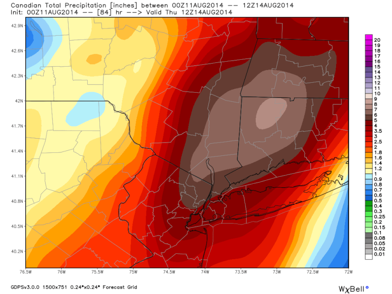
jmanley32 wrote:Looking like the rain will be more substanial that 1 inch, NWS showing on graphic 2-3+ inches. Not mentioning svr wx or wind though. Have not checked models but last ones I saw still developed the second low to at least 1000mb. CMC had like 994mb i think.
Here is Tuesday on the WPC

_________________
Mugs
AKA:King: Snow Weenie
Self Proclaimed
WINTER 2014-15 : 55.12" +.02 for 6 coatings (avg. 35")
WINTER 2015-16 Total - 29.8" (Avg 35")
WINTER 2016-17 : 39.5" so far

amugs- Advanced Forecaster - Mod
- Posts : 15093
Reputation : 213
Join date : 2013-01-07
Age : 54
Location : Hillsdale,NJ
Re: August 2014 Observations / Discussions Thread
![]() by amugs Sun Aug 10, 2014 11:35 pm
by amugs Sun Aug 10, 2014 11:35 pm

_________________
Mugs
AKA:King: Snow Weenie
Self Proclaimed
WINTER 2014-15 : 55.12" +.02 for 6 coatings (avg. 35")
WINTER 2015-16 Total - 29.8" (Avg 35")
WINTER 2016-17 : 39.5" so far
amugs- Advanced Forecaster - Mod
- Posts : 15093
Reputation : 213
Join date : 2013-01-07
Age : 54
Location : Hillsdale,NJ
Re: August 2014 Observations / Discussions Thread
![]() by Frank_Wx Sun Aug 10, 2014 11:43 pm
by Frank_Wx Sun Aug 10, 2014 11:43 pm
_________________
_______________________________________________________________________________________________________
CLICK HERE to view NJ Strong Snowstorm Classifications
Frank_Wx- Godzilla Seeker
- Posts : 21305
Reputation : 328
Join date : 2013-01-05
Age : 31
Location : Jersey City, NJ -
Re: August 2014 Observations / Discussions Thread
![]() by jmanley32 Mon Aug 11, 2014 8:39 am
by jmanley32 Mon Aug 11, 2014 8:39 am
.DAYS TWO THROUGH SEVEN...TUESDAY THROUGH SUNDAY.
THERE IS THE POTENTIAL FOR 1 1/2 TO 3 INCHES OF RAIN...WITH
LOCALLY HIGHER AMOUNTS POSSIBLE...FROM TUESDAY THROUGH WEDNESDAY.
AS A RESULT THERE IS A CHANCE FOR FLASH FLOODING.
.SPOTTER INFORMATION STATEMENT...
SPOTTER ACTIVATION MAY BE NEEDED TUESDAY AND WEDNESDAY.
Could have used the rain Saturday night, major 3 alarm fire near me arson by ateenager, started it in his moms house and it spread and destroyed dwellings to 35 people. That kid is in alot of trouble. To say the least!
jmanley32- Senior Enthusiast
- Posts : 20513
Reputation : 108
Join date : 2013-12-12
Age : 42
Location : Yonkers, NY
Re: August 2014 Observations / Discussions Thread
![]() by jmanley32 Mon Aug 11, 2014 8:51 am
by jmanley32 Mon Aug 11, 2014 8:51 am
jmanley32- Senior Enthusiast
- Posts : 20513
Reputation : 108
Join date : 2013-12-12
Age : 42
Location : Yonkers, NY
Re: August 2014 Observations / Discussions Thread
![]() by jmanley32 Mon Aug 11, 2014 8:54 am
by jmanley32 Mon Aug 11, 2014 8:54 am
 [/url]
jmanley32- Senior Enthusiast
- Posts : 20513
Reputation : 108
Join date : 2013-12-12
Age : 42
Location : Yonkers, NY
Re: August 2014 Observations / Discussions Thread
![]() by jmanley32 Mon Aug 11, 2014 3:36 pm
by jmanley32 Mon Aug 11, 2014 3:36 pm
jmanley32- Senior Enthusiast
- Posts : 20513
Reputation : 108
Join date : 2013-12-12
Age : 42
Location : Yonkers, NY
Re: August 2014 Observations / Discussions Thread
![]() by amugs Mon Aug 11, 2014 6:07 pm
by amugs Mon Aug 11, 2014 6:07 pm
If we get training which is possible then we could get IMO the 2" amount + for some of us.
Then thurs and fri mid to upper 70's and lows in the low 60's would not be surprised to see some 50's for those in the outlining burbs.
_________________
Mugs
AKA:King: Snow Weenie
Self Proclaimed
WINTER 2014-15 : 55.12" +.02 for 6 coatings (avg. 35")
WINTER 2015-16 Total - 29.8" (Avg 35")
WINTER 2016-17 : 39.5" so far
amugs- Advanced Forecaster - Mod
- Posts : 15093
Reputation : 213
Join date : 2013-01-07
Age : 54
Location : Hillsdale,NJ
Re: August 2014 Observations / Discussions Thread
![]() by jmanley32 Mon Aug 11, 2014 11:04 pm
by jmanley32 Mon Aug 11, 2014 11:04 pm
jmanley32- Senior Enthusiast
- Posts : 20513
Reputation : 108
Join date : 2013-12-12
Age : 42
Location : Yonkers, NY
Re: August 2014 Observations / Discussions Thread
![]() by jmanley32 Mon Aug 11, 2014 11:09 pm
by jmanley32 Mon Aug 11, 2014 11:09 pm
THIS FORECAST MOSTLY FOLLOWS A BLEND OF THE 12Z GFS AND 00Z/12Z
ECMWF...WITH SOME MODIFICATIONS. FIRST...DEEP LAYER S-SE FLOW
AHEAD OF A FRONTAL SYSTEM TO THE WEST SHOULD BECOME ESTABLISHED...
WITH INCREASING CHANCES FOR SHOWERS FROM WEST-EAST THROUGH THE
DAY...THOUGH NOT QUITE AS FAST AS THE GFS WHICH LOOKS TO BE
SUFFERING FROM GRID-SCALE CONVECTIVE FEEDBACK EARLY ON. POP SHOULD
INCREASE TO CHANCE BY AFTERNOON FOR MOST OF LONG ISLAND AND
SOUTHERN CT...AND LIKELY FARTHER WEST INCLUDING NYC METRO.
NOT EXPECTING HEAVY RAIN OR TSTMS AT THIS POINT. CLOUD COVER AND
PRECIP SHOULD KEEP HIGH TEMPS SUPPRESSED...WITH MID AND UPPER
70S.
POTENTIAL FOR HEAVY RAIN AND FLOODING INCREASES TUE NIGHT VIA
COMBINATION OF FAVORABLE MOISTURE...LIFT AND INSTABILITY.
INGREDIENTS THAT LOOK TO COME TOGETHER FOR HEAVY RAIN AND FLASH
FLOODING INCLUDE DEEP MOISTURE WITH BOTH PW AND PRECIP EFFICIENCY
INCREASING TO 2 INCHES...AND A DEEP WARM CLOUD LAYER WITH WEAK
INSTABILITY AND TALL/SKINNY MUCAPE 500-1000 J/KG HELPING PROMOTE
WARM RAIN PROCESSES...ALSO MULTIPLE SOURCES OF LIFT INCLUDING
THE APPROACH OF A NEGATIVELY TILTED UPPER TROUGH...COUPLED/DIFLUENT
UPPER JET STREAKS...OROGRAPHIC LIFT VIA LOW LEVEL S-SE FLOW WITH A
40-KT H9 LLJ...ALSO ENHANCED LOW LEVEL WAA AHEAD OF A SECONDARY
LOW THAT DEVELOPS JUST WEST OF NYC LATE. A FLASH FLOOD WATCH HAS
BEEN ISSUED FOR THE ENTIRE CWA FOR LATE TUE NIGHT INTO WED AS A
RESULT.
A LOW CAPE-HIGH SHEAR ENVIRONMENT WILL ALSO BECOME ESTABLISHED
IN TANDEM WITH WITH DEVELOPMENT OF THE SECONDARY LOW LATE TUE
NIGHT INTO WED MORNING OR EARLY WED AFTERNOON. BRN BETWEEN
10-50...HIGH 0-1 KM SHEAR AND VEERING LOW LEVEL WIND PROFILES FROM
SE-S WITH HEIGHT...LOW LCLS...AND LOW LEVEL WAA AHEAD OF THE LOW
AND AN ASSOCIATED WARM FRONT LIFTING INTO THE AREA...SUGGEST
POTENTIAL FOR AN ISOLD STORM OR TWO TO PRODUCE DAMAGING WINDS OR A
BRIEF TORNADO.
jmanley32- Senior Enthusiast
- Posts : 20513
Reputation : 108
Join date : 2013-12-12
Age : 42
Location : Yonkers, NY
Re: August 2014 Observations / Discussions Thread
![]() by Quietace Tue Aug 12, 2014 10:08 am
by Quietace Tue Aug 12, 2014 10:08 am


Quietace- Meteorologist - Mod

- Posts : 3687
Reputation : 33
Join date : 2013-01-07
Age : 27
Location : Point Pleasant, NJ
Re: August 2014 Observations / Discussions Thread
![]() by jmanley32 Tue Aug 12, 2014 10:30 am
by jmanley32 Tue Aug 12, 2014 10:30 am
jmanley32- Senior Enthusiast
- Posts : 20513
Reputation : 108
Join date : 2013-12-12
Age : 42
Location : Yonkers, NY
Re: August 2014 Observations / Discussions Thread
![]() by jmanley32 Tue Aug 12, 2014 10:34 am
by jmanley32 Tue Aug 12, 2014 10:34 am
jmanley32- Senior Enthusiast
- Posts : 20513
Reputation : 108
Join date : 2013-12-12
Age : 42
Location : Yonkers, NY
Re: August 2014 Observations / Discussions Thread
![]() by Quietace Tue Aug 12, 2014 11:01 am
by Quietace Tue Aug 12, 2014 11:01 am

Quietace- Meteorologist - Mod
- Posts : 3687
Reputation : 33
Join date : 2013-01-07
Age : 27
Location : Point Pleasant, NJ
Re: August 2014 Observations / Discussions Thread
![]() by Frank_Wx Tue Aug 12, 2014 12:08 pm
by Frank_Wx Tue Aug 12, 2014 12:08 pm
_________________
_______________________________________________________________________________________________________
CLICK HERE to view NJ Strong Snowstorm Classifications
Frank_Wx- Godzilla Seeker
- Posts : 21305
Reputation : 328
Join date : 2013-01-05
Age : 31
Location : Jersey City, NJ -
Re: August 2014 Observations / Discussions Thread
![]() by jmanley32 Tue Aug 12, 2014 1:21 pm
by jmanley32 Tue Aug 12, 2014 1:21 pm
jmanley32- Senior Enthusiast
- Posts : 20513
Reputation : 108
Join date : 2013-12-12
Age : 42
Location : Yonkers, NY
Re: August 2014 Observations / Discussions Thread
![]() by amugs Tue Aug 12, 2014 3:53 pm
by amugs Tue Aug 12, 2014 3:53 pm
Sporadic rain/drizzle up here at 74*.
_________________
Mugs
AKA:King: Snow Weenie
Self Proclaimed
WINTER 2014-15 : 55.12" +.02 for 6 coatings (avg. 35")
WINTER 2015-16 Total - 29.8" (Avg 35")
WINTER 2016-17 : 39.5" so far
amugs- Advanced Forecaster - Mod
- Posts : 15093
Reputation : 213
Join date : 2013-01-07
Age : 54
Location : Hillsdale,NJ

Quietace- Meteorologist - Mod
- Posts : 3687
Reputation : 33
Join date : 2013-01-07
Age : 27
Location : Point Pleasant, NJ
Page 2 of 7 • 1, 2, 3, 4, 5, 6, 7 ![]()
|
|
|