
 Search
Official Long Range Thread 5.0
Page 16 of 40 •  1 ... 9 ... 15, 16, 17 ... 28 ... 40
 ![]()
Re: Official Long Range Thread 5.0
![]() by Frank_Wx Tue Dec 23, 2014 1:27 am
by Frank_Wx Tue Dec 23, 2014 1:27 am

Frank_Wx- Godzilla Seeker

- Posts : 21305
Join date : 2013-01-05 -


Frank_Wx- Godzilla Seeker
- Posts : 21305
Join date : 2013-01-05 -
Re: Official Long Range Thread 5.0
![]() by Frank_Wx Tue Dec 23, 2014 1:37 am
by Frank_Wx Tue Dec 23, 2014 1:37 am
_________________
_______________________________________________________________________________________________________
CLICK HERE to view NJ Strong Snowstorm Classifications

Frank_Wx- Godzilla Seeker
- Posts : 21305
Reputation : 328
Join date : 2013-01-05
Age : 31
Location : Jersey City, NJ -
Re: Official Long Range Thread 5.0
![]() by jmanley32 Tue Dec 23, 2014 9:18 am
by jmanley32 Tue Dec 23, 2014 9:18 am

jmanley32- Senior Enthusiast

- Posts : 20517
Reputation : 108
Join date : 2013-12-12
Age : 42
Location : Yonkers, NY
Re: Official Long Range Thread 5.0
![]() by Frank_Wx Tue Dec 23, 2014 10:53 am
by Frank_Wx Tue Dec 23, 2014 10:53 am

_________________
_______________________________________________________________________________________________________
CLICK HERE to view NJ Strong Snowstorm Classifications
Frank_Wx- Godzilla Seeker
- Posts : 21305
Reputation : 328
Join date : 2013-01-05
Age : 31
Location : Jersey City, NJ -
Re: Official Long Range Thread 5.0
![]() by Frank_Wx Tue Dec 23, 2014 11:02 am
by Frank_Wx Tue Dec 23, 2014 11:02 am

Along with the jet streak we have a Rex Block developing on the ,odes in the east Pac. That's when there is a low pressure system beneath a dome of high pressure. That will help our -EPO flex
_________________
_______________________________________________________________________________________________________
CLICK HERE to view NJ Strong Snowstorm Classifications
Frank_Wx- Godzilla Seeker
- Posts : 21305
Reputation : 328
Join date : 2013-01-05
Age : 31
Location : Jersey City, NJ -
Re: Official Long Range Thread 5.0
![]() by Frank_Wx Tue Dec 23, 2014 11:39 am
by Frank_Wx Tue Dec 23, 2014 11:39 am

_________________
_______________________________________________________________________________________________________
CLICK HERE to view NJ Strong Snowstorm Classifications
Frank_Wx- Godzilla Seeker
- Posts : 21305
Reputation : 328
Join date : 2013-01-05
Age : 31
Location : Jersey City, NJ -
Re: Official Long Range Thread 5.0
![]() by aiannone Tue Dec 23, 2014 12:06 pm
by aiannone Tue Dec 23, 2014 12:06 pm
_________________
-Alex Iannone-

aiannone- Senior Enthusiast - Mod

- Posts : 4814
Reputation : 92
Join date : 2013-01-07
Location : Saint James, LI (Northwest Suffolk Co.)
Re: Official Long Range Thread 5.0
![]() by aiannone Tue Dec 23, 2014 1:14 pm
by aiannone Tue Dec 23, 2014 1:14 pm
_________________
-Alex Iannone-
aiannone- Senior Enthusiast - Mod
- Posts : 4814
Reputation : 92
Join date : 2013-01-07
Location : Saint James, LI (Northwest Suffolk Co.)
Re: Official Long Range Thread 5.0
![]() by Frank_Wx Tue Dec 23, 2014 1:26 pm
by Frank_Wx Tue Dec 23, 2014 1:26 pm
_________________
_______________________________________________________________________________________________________
CLICK HERE to view NJ Strong Snowstorm Classifications
Frank_Wx- Godzilla Seeker
- Posts : 21305
Reputation : 328
Join date : 2013-01-05
Age : 31
Location : Jersey City, NJ -
Re: Official Long Range Thread 5.0
![]() by Guest Tue Dec 23, 2014 1:31 pm
by Guest Tue Dec 23, 2014 1:31 pm
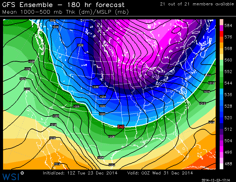
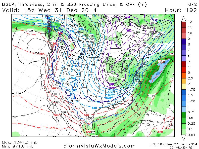
aiannone wrote:12z GFS Ensemble is very similar to the 12z GFS Operational in the sense that it keeps the cold around for the entire run, with the PV entering as well. Also has a few snow chances down to the coast as well. Winter Cancel Weenies may have to put the white flag back in their pocket for a little while
WHAT'S THE QUOTE FROM THE GODFATHER? something like "Just when I thought I was out they suck me back in" or something. That's what you guys are doing to me and I LIKE IT!!
Guest- Guest
Re: Official Long Range Thread 5.0
![]() by jmanley32 Tue Dec 23, 2014 1:42 pm
by jmanley32 Tue Dec 23, 2014 1:42 pm
jmanley32- Senior Enthusiast
- Posts : 20517
Reputation : 108
Join date : 2013-12-12
Age : 42
Location : Yonkers, NY
Re: Official Long Range Thread 5.0
![]() by jmanley32 Tue Dec 23, 2014 1:45 pm
by jmanley32 Tue Dec 23, 2014 1:45 pm
jmanley32- Senior Enthusiast
- Posts : 20517
Reputation : 108
Join date : 2013-12-12
Age : 42
Location : Yonkers, NY
Re: Official Long Range Thread 5.0
![]() by Dunnzoo Tue Dec 23, 2014 3:34 pm
by Dunnzoo Tue Dec 23, 2014 3:34 pm
WHAT'S THE QUOTE FROM THE GODFATHER? something like "Just when I thought I was out they suck me back in" or something. That's what you guys are doing to me and I LIKE IT!![/quote]
Haha same here... trying to get all my baking done and it's such a distraction!
_________________
Janet
Snowfall winter of 2023-2024 17.5"
Snowfall winter of 2022-2023 6.0"
Snowfall winter of 2021-2022 17.6" 1" sleet 2/25/22
Snowfall winter of 2020-2021 51.1"
Snowfall winter of 2019-2020 8.5"
Snowfall winter of 2018-2019 25.1"
Snowfall winter of 2017-2018 51.9"
Snowfall winter of 2016-2017 45.6"
Snowfall winter of 2015-2016 29.5"
Snowfall winter of 2014-2015 50.55"
Snowfall winter of 2013-2014 66.5"

Dunnzoo- Senior Enthusiast - Mod
- Posts : 4892
Reputation : 68
Join date : 2013-01-11
Age : 62
Location : Westwood, NJ
Re: Official Long Range Thread 5.0
![]() by sroc4 Tue Dec 23, 2014 3:43 pm
by sroc4 Tue Dec 23, 2014 3:43 pm
"Let’s dive into the big question of the day, week, and this month. What the heck happened to winter?
Okay, fair question. So let’s find out because as you know all the features I have been watching have fallen into place. There is of course one exception that I actually warned about in the winter forecast. That one factor that had me concerned was the QBO.
Yesterday in fact, David T. of WXRisk.com and I had a very public chat about this concern and we both had come to the same conclusion. The QBO was the problem here and this needs to be addressed. As discussed in the winter forecast, the QBO was an interesting factor. On one hand, you want a negative QBO. On the other hand, you don’t want the QBO to be too strong. My thoughts were that although the QBO was strongly negative, that the QBO would start to weaken to a more moderate level leading to the Polar jet stream over the Pacific to weaken and allow the blocking to take shape. Otherwise, you have too much of a good thing. Think of it like having a giant scoop of ice-cream. Who doesn’t like ice cream? Right!
However, if you have too much too fast, you get a heck of a headache. Well, the atmosphere has a head ache and that headache is giving me a headache as well along with indigestion. Okay, enough with the health stuff.
Look, the key point here is the QBO at 30 MB must weaken and fall steadily. That happens then the Pacific jet stream weakens, high latitude blocking falls into place because of all the other factors that I have discussed, and everyone is happy.
So here is the good news:
Screen Shot 2014-12-23 at 5.17.50 AM
The numbers above are the QBO values at 30 MB for all of 2014. The QBO typically peaks in a positive or negative phase every 6 months. Never in any recorded cases going back to 1950 has the QBO ever constantly increased or decreased for more than 6 months. Further, there are no cases of the QBO being this strong and then not rapidly weakening there after. We appeared to have reached that peak back in October at -23.86. The idea was the QBO would start to weaken in November, which it did, but just not fast enough. The raw data suggest the QBO is slowly but steadily weakening this month as well, but again not as fast as I had thought it would. However the trends are such that as the QBO weakens, the high latitude blocking will come and with it the winter pattern I was expecting. Then you have the +PDO, the Siberian snow influences, the supportive Atlantic SSTA, and a clearly west based El Nino (I’ll discuss tomorrow) all to have an influence for January, February, and March.
So the good news this morning is we know what is wrong and we know that the trends point to more favorable conditions on the way. Got to love science. See, if you study the physics and not worry about model output or yearly comparisons, you can quickly find the problem to a forecast and adjust.
As the QBO falls, the Pacific jet streaks will weaken, the MJO will fall into line, and the high latitude blocking starts to set in."
_________________
"In weather and in life, there's no winning and losing; there's only winning and learning."
WINTER 2012/2013 TOTALS 43.65"WINTER 2017/2018 TOTALS 62.85" WINTER 2022/2023 TOTALS 4.9"
WINTER 2013/2014 TOTALS 64.85"WINTER 2018/2019 TOTALS 14.25" WINTER 2023/2024 TOTALS 13.1"
WINTER 2014/2015 TOTALS 71.20"WINTER 2019/2020 TOTALS 6.35"
WINTER 2015/2016 TOTALS 35.00"WINTER 2020/2021 TOTALS 37.75"
WINTER 2016/2017 TOTALS 42.25"WINTER 2021/2022 TOTALS 31.65"

sroc4- Admin
- Posts : 8331
Reputation : 301
Join date : 2013-01-07
Location : Wading River, LI
Re: Official Long Range Thread 5.0
![]() by jmanley32 Tue Dec 23, 2014 4:25 pm
by jmanley32 Tue Dec 23, 2014 4:25 pm
jmanley32- Senior Enthusiast
- Posts : 20517
Reputation : 108
Join date : 2013-12-12
Age : 42
Location : Yonkers, NY
Re: Official Long Range Thread 5.0
![]() by Frank_Wx Tue Dec 23, 2014 4:45 pm
by Frank_Wx Tue Dec 23, 2014 4:45 pm
_________________
_______________________________________________________________________________________________________
CLICK HERE to view NJ Strong Snowstorm Classifications
Frank_Wx- Godzilla Seeker
- Posts : 21305
Reputation : 328
Join date : 2013-01-05
Age : 31
Location : Jersey City, NJ -
Re: Official Long Range Thread 5.0
![]() by aiannone Tue Dec 23, 2014 5:45 pm
by aiannone Tue Dec 23, 2014 5:45 pm

Bundle UP
_________________
-Alex Iannone-
aiannone- Senior Enthusiast - Mod
- Posts : 4814
Reputation : 92
Join date : 2013-01-07
Location : Saint James, LI (Northwest Suffolk Co.)
Re: Official Long Range Thread 5.0
![]() by sroc4 Tue Dec 23, 2014 6:11 pm
by sroc4 Tue Dec 23, 2014 6:11 pm
Frank_Wx wrote:I'll explain QBO to you guys when I get home, or at least doy best
Frank if you have links to papers or anything that would be awesome too.
_________________
"In weather and in life, there's no winning and losing; there's only winning and learning."
WINTER 2012/2013 TOTALS 43.65"WINTER 2017/2018 TOTALS 62.85" WINTER 2022/2023 TOTALS 4.9"
WINTER 2013/2014 TOTALS 64.85"WINTER 2018/2019 TOTALS 14.25" WINTER 2023/2024 TOTALS 13.1"
WINTER 2014/2015 TOTALS 71.20"WINTER 2019/2020 TOTALS 6.35"
WINTER 2015/2016 TOTALS 35.00"WINTER 2020/2021 TOTALS 37.75"
WINTER 2016/2017 TOTALS 42.25"WINTER 2021/2022 TOTALS 31.65"
sroc4- Admin
- Posts : 8331
Reputation : 301
Join date : 2013-01-07
Location : Wading River, LI
Re: Official Long Range Thread 5.0
![]() by nutleyblizzard Tue Dec 23, 2014 6:48 pm
by nutleyblizzard Tue Dec 23, 2014 6:48 pm
Frank can you please give us the latest QBO reading? I remember reading at another weatherboard that an optimum number for snow and cold is -10 QBO.Frank_Wx wrote:I'll explain QBO to you guys when I get home, or at least doy best

nutleyblizzard- Senior Enthusiast
- Posts : 1952
Reputation : 41
Join date : 2014-01-30
Age : 58
Location : Nutley, new jersey
Re: Official Long Range Thread 5.0
![]() by CPcantmeasuresnow Tue Dec 23, 2014 6:55 pm
by CPcantmeasuresnow Tue Dec 23, 2014 6:55 pm

CPcantmeasuresnow- Wx Statistician Guru

- Posts : 7274
Reputation : 230
Join date : 2013-01-07
Age : 103
Location : Eastern Orange County, NY
Re: Official Long Range Thread 5.0
![]() by nutleyblizzard Tue Dec 23, 2014 7:15 pm
by nutleyblizzard Tue Dec 23, 2014 7:15 pm
My take on the QBO is that it correlates with the speed of upper level winds. Right now the QBO is too strong, which makes the pattern too progressive. Good news is that the QBO is weakening, just not as fast as forecasters thought.CPcantmeasuresnow wrote:Man I was barely starting to grasp the stratospheric warming now I have to know what the QBO is? Does it ever end?
nutleyblizzard- Senior Enthusiast
- Posts : 1952
Reputation : 41
Join date : 2014-01-30
Age : 58
Location : Nutley, new jersey
Re: Official Long Range Thread 5.0
![]() by nutleyblizzard Tue Dec 23, 2014 7:41 pm
by nutleyblizzard Tue Dec 23, 2014 7:41 pm
nutleyblizzard- Senior Enthusiast
- Posts : 1952
Reputation : 41
Join date : 2014-01-30
Age : 58
Location : Nutley, new jersey
Re: Official Long Range Thread 5.0
![]() by Frank_Wx Tue Dec 23, 2014 10:20 pm
by Frank_Wx Tue Dec 23, 2014 10:20 pm
The QBO studies the wind directions in the upper stratosphere. They will either be in an easterly or westerly direction.
Positive QBO = easterlies
Negative QBO = westerlies
A QBO is measured on an index like other signals (NAO, AO, PDO, etc...) so it has values. QBO values between -8 and +8 is considered "neutral" territory. Anything above +8 is positive, vice-versa for negative.
At the beginning of Meteorological winter, the QBO was around -23.00!! That is extremely negative. One thing about an extreme negative QBO (remember, extremes are bad) is that it amplifies the Pacific Jet too much and the Polar Jet remains locked up in Canada. When the QBO goes from a negative state toward a positive one, it means blocking (-NAO) has a good chance of developing because the zonal winds are shifting from west to east.
Remember how I always say the "extreme" is never a good thing for us? For example, when the EPO last season reached extreme negative values, the PV dropped so far south that energy got sheared apart. Hence the dry spell from mid-February into March last year.
Currently, our QBO is -25, which is near record territory and way too negative. This is why the Stratosphere has been so stubborn lately with getting a sudden stratospheric warming event to verify. If it does not begin making its match toward neutral territory soon, the Pacific Jet will end up messing with the PNA out west and the southeast ridge could become a dominant feature this winter.
A lot of people feel the QBO will eventually revert, because it comes in cycles.
DT has the best explanation...read more here
https://www.facebook.com/notes/wxriskcom/another-piece-of-the-winter-2013-14-puzzle-oct-qbo-value-1169/600112926702636
_________________
_______________________________________________________________________________________________________
CLICK HERE to view NJ Strong Snowstorm Classifications
Frank_Wx- Godzilla Seeker
- Posts : 21305
Reputation : 328
Join date : 2013-01-05
Age : 31
Location : Jersey City, NJ -
Re: Official Long Range Thread 5.0
![]() by Frank_Wx Tue Dec 23, 2014 10:30 pm
by Frank_Wx Tue Dec 23, 2014 10:30 pm
_________________
_______________________________________________________________________________________________________
CLICK HERE to view NJ Strong Snowstorm Classifications
Frank_Wx- Godzilla Seeker
- Posts : 21305
Reputation : 328
Join date : 2013-01-05
Age : 31
Location : Jersey City, NJ -
Re: Official Long Range Thread 5.0
![]() by sroc4 Tue Dec 23, 2014 10:31 pm
by sroc4 Tue Dec 23, 2014 10:31 pm
_________________
"In weather and in life, there's no winning and losing; there's only winning and learning."
WINTER 2012/2013 TOTALS 43.65"WINTER 2017/2018 TOTALS 62.85" WINTER 2022/2023 TOTALS 4.9"
WINTER 2013/2014 TOTALS 64.85"WINTER 2018/2019 TOTALS 14.25" WINTER 2023/2024 TOTALS 13.1"
WINTER 2014/2015 TOTALS 71.20"WINTER 2019/2020 TOTALS 6.35"
WINTER 2015/2016 TOTALS 35.00"WINTER 2020/2021 TOTALS 37.75"
WINTER 2016/2017 TOTALS 42.25"WINTER 2021/2022 TOTALS 31.65"
sroc4- Admin
- Posts : 8331
Reputation : 301
Join date : 2013-01-07
Location : Wading River, LI
Re: Official Long Range Thread 5.0
![]() by Frank_Wx Tue Dec 23, 2014 10:50 pm
by Frank_Wx Tue Dec 23, 2014 10:50 pm
Best thing to do right now is follow the period between the 28th and 7th - it has good potential despite the -PNA/+NAO - then we'll worry about the pattern once we get some more answers.

_________________
_______________________________________________________________________________________________________
CLICK HERE to view NJ Strong Snowstorm Classifications
Frank_Wx- Godzilla Seeker
- Posts : 21305
Reputation : 328
Join date : 2013-01-05
Age : 31
Location : Jersey City, NJ -
Page 16 of 40 • 1 ... 9 ... 15, 16, 17 ... 28 ... 40 ![]()
|
|
|