
 Search
Official Long Range Thread 5.0
Page 9 of 40 •  1 ... 6 ... 8, 9, 10 ... 24 ... 40
 ![]()
Re: Official Long Range Thread 5.0
![]() by HectorO Thu Dec 18, 2014 8:56 am
by HectorO Thu Dec 18, 2014 8:56 am
syosnow94 wrote:docstox12 wrote:I wonder what the pattern was going into the 1995-1996 killer winter we had here.There was snowpack from late-November to early April.Seems to me you want the favorable pattern locked in by late November and not have to keep pushing it further and further down the line.
Exactly what I've been saying since I joined this forum. In a nutshell screw science and models. If we get cold and snow early it sets the stage and we get future storms and corresponding weather. The snowcover lowers temps and storms follow the same path. We haven't had that and I would Respectfully point out that many forecasts of upcoming storms and cold potential keep busting and being delayed. docstox12 put my feelings into words perfectly!!
Talking about a pattern lock not really early snow. Early snow has been a curse for us over the past few decades. 2011 is an example. I think we were all spoiled by 08/09, 09/10 and 10/11. Those were 3 great years. I think this winter will resemble 11/12 but not as mild or snowless.
HectorO- Pro Enthusiast

- Posts : 959
Join date : 2013-01-11
Re: Official Long Range Thread 5.0
![]() by GreyBeard Thu Dec 18, 2014 9:07 am
by GreyBeard Thu Dec 18, 2014 9:07 am
Don't see any more posts on pattern changes that Frank was hyping and his blog describing why that was going to occur has mysteriously disappeared.(either that or I can't find it).
Guys are saying wait until mid January or even February 'til things start happening.We shall see.
As I said I'm more of an observer here than a poster, but that's the vibe I'm getting. I'm also not it the best of moods as I took a fall in the shower Monday night and fractured rib #6 in the back. It hurts just to breathe. Wouldn't wish this on anybody,but on the up side, I've got more time to study the board as I recuperate. Sorry for the rant, regards and best wishes to all.
GreyBeard- Senior Enthusiast

- Posts : 725
Join date : 2014-02-12
Re: Official Long Range Thread 5.0
![]() by Frank_Wx Thu Dec 18, 2014 9:16 am
by Frank_Wx Thu Dec 18, 2014 9:16 am
GreyBeard wrote:Wow,just pop my head in here on occasion to get the skuttlebut. Haven't been in a while and boy how things have changed. Looks more like Easter weather on Christmas Eve with rain and temps approaching 60.
Don't see any more posts on pattern changes that Frank was hyping and his blog describing why that was going to occur has mysteriously disappeared.(either that or I can't find it).
Guys are saying wait until mid January or even February 'til things start happening.We shall see.
As I said I'm more of an observer here than a poster, but that's the vibe I'm getting. I'm also not it the best of moods as I took a fall in the shower Monday night and fractured rib #6 in the back. It hurts just to breathe. Wouldn't wish this on anybody,but on the up side, I've got more time to study the board as I recuperate. Sorry for the rant, regards and best wishes to all.
The blog is in the locked thread, but I'll post it here again. If you read it carefully, I said the 20th-24th would be a transition period (wild card storm being on thr 20th but obviously that's not happening). 25th and on is when I expect us to get in a better pattern. And just because the long range models say otherwise, does not mean I'm agreeing with it.
http://njstrongweather.blogspot.com/2014/12/december-20th-21st-coastal-storm.html
_________________
_______________________________________________________________________________________________________
CLICK HERE to view NJ Strong Snowstorm Classifications

Frank_Wx- Godzilla Seeker

- Posts : 21305
Reputation : 328
Join date : 2013-01-05
Age : 31
Location : Jersey City, NJ -

Re: Official Long Range Thread 5.0
![]() by Frank_Wx Thu Dec 18, 2014 9:19 am
by Frank_Wx Thu Dec 18, 2014 9:19 am
syosnow94 wrote:docstox12 wrote:I wonder what the pattern was going into the 1995-1996 killer winter we had here.There was snowpack from late-November to early April.Seems to me you want the favorable pattern locked in by late November and not have to keep pushing it further and further down the line.
Exactly what I've been saying since I joined this forum. In a nutshell screw science and models. If we get cold and snow early it sets the stage and we get future storms and corresponding weather. The snowcover lowers temps and storms follow the same path. We haven't had that and I would Respectfully point out that many forecasts of upcoming storms and cold potential keep busting and being delayed. docstox12 put my feelings into words perfectly!!
Where exactly do you think we live? This is the NYC Metro area not Canada. You're right about the snow cover but that mainly applies to us between January and February. Plus, the most important regions to have snow cover are western Canada because as troughs come down the air temperature does not moderate as much.
_________________
_______________________________________________________________________________________________________
CLICK HERE to view NJ Strong Snowstorm Classifications
Frank_Wx- Godzilla Seeker
- Posts : 21305
Reputation : 328
Join date : 2013-01-05
Age : 31
Location : Jersey City, NJ -
Re: Official Long Range Thread 5.0
![]() by GreyBeard Thu Dec 18, 2014 9:22 am
by GreyBeard Thu Dec 18, 2014 9:22 am
GreyBeard- Senior Enthusiast
- Posts : 725
Reputation : 34
Join date : 2014-02-12
Location : eastern nassau county
Re: Official Long Range Thread 5.0
![]() by Frank_Wx Thu Dec 18, 2014 9:23 am
by Frank_Wx Thu Dec 18, 2014 9:23 am
_________________
_______________________________________________________________________________________________________
CLICK HERE to view NJ Strong Snowstorm Classifications
Frank_Wx- Godzilla Seeker
- Posts : 21305
Reputation : 328
Join date : 2013-01-05
Age : 31
Location : Jersey City, NJ -
Re: Official Long Range Thread 5.0
![]() by Frank_Wx Thu Dec 18, 2014 9:26 am
by Frank_Wx Thu Dec 18, 2014 9:26 am
GreyBeard wrote:Thanks for the blog link, Frank. Just rustling your feathers a little bit, all in fun
No worries, people are nervously reacting all across the weather community not just here. Just like any storm, models will lose it then bring it back. I think that's the case here as well. And trust me, if by Xmas Eve or even as early as Monday of next week and the models still are showing a delay then I'll be the first to admit I was wrong.
Another thing to keep I thr back of your minds is the Stratosphere continues to warm and those effects usually have a 2-week lag time.
_________________
_______________________________________________________________________________________________________
CLICK HERE to view NJ Strong Snowstorm Classifications
Frank_Wx- Godzilla Seeker
- Posts : 21305
Reputation : 328
Join date : 2013-01-05
Age : 31
Location : Jersey City, NJ -
Re: Official Long Range Thread 5.0
![]() by amugs Thu Dec 18, 2014 9:42 am
by amugs Thu Dec 18, 2014 9:42 am

_________________
Mugs
AKA:King: Snow Weenie
Self Proclaimed
WINTER 2014-15 : 55.12" +.02 for 6 coatings (avg. 35")
WINTER 2015-16 Total - 29.8" (Avg 35")
WINTER 2016-17 : 39.5" so far

amugs- Advanced Forecaster - Mod

- Posts : 15093
Reputation : 213
Join date : 2013-01-07
Age : 54
Location : Hillsdale,NJ
Re: Official Long Range Thread 5.0
![]() by Frank_Wx Thu Dec 18, 2014 10:20 am
by Frank_Wx Thu Dec 18, 2014 10:20 am
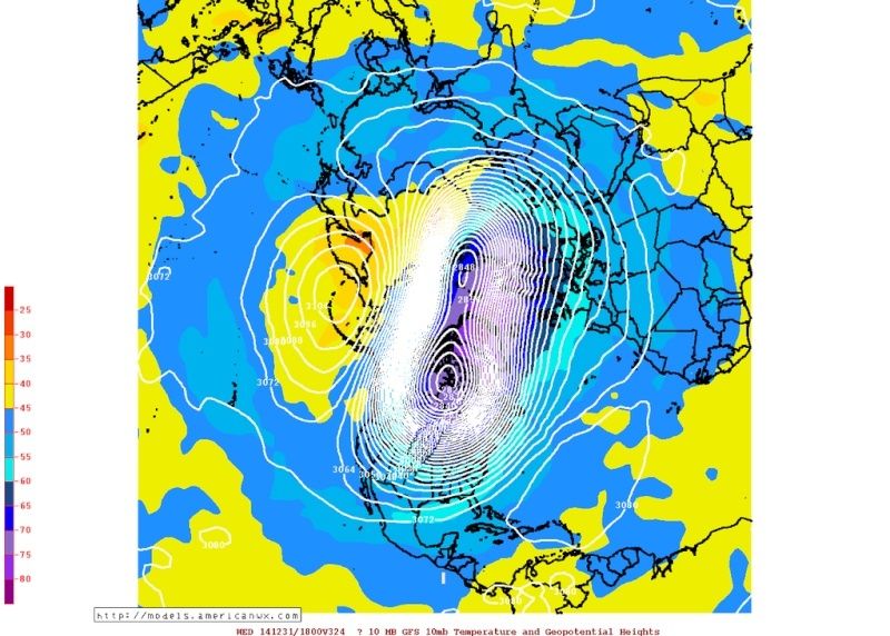
GFS at 10 mb level in the stratosphere is splitting the PV still. This would mean much colder than normal weather sometime first week of January
_________________
_______________________________________________________________________________________________________
CLICK HERE to view NJ Strong Snowstorm Classifications
Frank_Wx- Godzilla Seeker
- Posts : 21305
Reputation : 328
Join date : 2013-01-05
Age : 31
Location : Jersey City, NJ -
Re: Official Long Range Thread 5.0
![]() by amugs Thu Dec 18, 2014 10:33 am
by amugs Thu Dec 18, 2014 10:33 am

Also notice the + PNA in the west with this as the temps roar out there - f them I say and give me the cold with an active STJ
Its taking shape
_________________
Mugs
AKA:King: Snow Weenie
Self Proclaimed
WINTER 2014-15 : 55.12" +.02 for 6 coatings (avg. 35")
WINTER 2015-16 Total - 29.8" (Avg 35")
WINTER 2016-17 : 39.5" so far
amugs- Advanced Forecaster - Mod
- Posts : 15093
Reputation : 213
Join date : 2013-01-07
Age : 54
Location : Hillsdale,NJ
Re: Official Long Range Thread 5.0
![]() by amugs Thu Dec 18, 2014 10:56 am
by amugs Thu Dec 18, 2014 10:56 am


A muted/neutral PNA for the the later part of Dec - better than a -PNA .
The -EPO, -NAO and - AO can help overcome this if need be
_________________
Mugs
AKA:King: Snow Weenie
Self Proclaimed
WINTER 2014-15 : 55.12" +.02 for 6 coatings (avg. 35")
WINTER 2015-16 Total - 29.8" (Avg 35")
WINTER 2016-17 : 39.5" so far
amugs- Advanced Forecaster - Mod
- Posts : 15093
Reputation : 213
Join date : 2013-01-07
Age : 54
Location : Hillsdale,NJ
Re: Official Long Range Thread 5.0
![]() by Guest Thu Dec 18, 2014 11:54 am
by Guest Thu Dec 18, 2014 11:54 am
GreyBeard wrote:Wow,just pop my head in here on occasion to get the skuttlebut. Haven't been in a while and boy how things have changed. Looks more like Easter weather on Christmas Eve with rain and temps approaching 60.
Don't see any more posts on pattern changes that Frank was hyping and his blog describing why that was going to occur has mysteriously disappeared.(either that or I can't find it).
Guys are saying wait until mid January or even February 'til things start happening.We shall see.
As I said I'm more of an observer here than a poster, but that's the vibe I'm getting. I'm also not it the best of moods as I took a fall in the shower Monday night and fractured rib #6 in the back. It hurts just to breathe. Wouldn't wish this on anybody,but on the up side, I've got more time to study the board as I recuperate. Sorry for the rant, regards and best wishes to all.
Not true. Frank has actually been really honest and accurate in his forecasts. IMO he's pretty good at what he does.
Guest- Guest
Re: Official Long Range Thread 5.0
![]() by amugs Thu Dec 18, 2014 1:02 pm
by amugs Thu Dec 18, 2014 1:02 pm

_________________
Mugs
AKA:King: Snow Weenie
Self Proclaimed
WINTER 2014-15 : 55.12" +.02 for 6 coatings (avg. 35")
WINTER 2015-16 Total - 29.8" (Avg 35")
WINTER 2016-17 : 39.5" so far
amugs- Advanced Forecaster - Mod
- Posts : 15093
Reputation : 213
Join date : 2013-01-07
Age : 54
Location : Hillsdale,NJ
Re: Official Long Range Thread 5.0
![]() by jmanley32 Thu Dec 18, 2014 1:35 pm
by jmanley32 Thu Dec 18, 2014 1:35 pm

jmanley32- Senior Enthusiast
- Posts : 20517
Reputation : 108
Join date : 2013-12-12
Age : 42
Location : Yonkers, NY
Re: Official Long Range Thread 5.0
![]() by jmanley32 Thu Dec 18, 2014 1:41 pm
by jmanley32 Thu Dec 18, 2014 1:41 pm
jmanley32- Senior Enthusiast
- Posts : 20517
Reputation : 108
Join date : 2013-12-12
Age : 42
Location : Yonkers, NY
Re: Official Long Range Thread 5.0
![]() by jmanley32 Thu Dec 18, 2014 2:29 pm
by jmanley32 Thu Dec 18, 2014 2:29 pm
jmanley32- Senior Enthusiast
- Posts : 20517
Reputation : 108
Join date : 2013-12-12
Age : 42
Location : Yonkers, NY
Re: Official Long Range Thread 5.0
![]() by Frank_Wx Thu Dec 18, 2014 2:30 pm
by Frank_Wx Thu Dec 18, 2014 2:30 pm
jmanley32 wrote:Frank post good luck today lol, your done! Now we can both relax for a bit, are you graduating or still have semesters left? I have one left ugg.
I'M SO DONE JMAN JUST GOT OUT OF THE EXAM!!!!! Praise Mary, Joseph, Jesus for getting me through college.
Start work Jan 5th
And the long range is flip flopping again. Go figure.
_________________
_______________________________________________________________________________________________________
CLICK HERE to view NJ Strong Snowstorm Classifications
Frank_Wx- Godzilla Seeker
- Posts : 21305
Reputation : 328
Join date : 2013-01-05
Age : 31
Location : Jersey City, NJ -
Re: Official Long Range Thread 5.0
![]() by jmanley32 Thu Dec 18, 2014 2:34 pm
by jmanley32 Thu Dec 18, 2014 2:34 pm
jmanley32- Senior Enthusiast
- Posts : 20517
Reputation : 108
Join date : 2013-12-12
Age : 42
Location : Yonkers, NY
Re: Official Long Range Thread 5.0
![]() by sroc4 Thu Dec 18, 2014 2:34 pm
by sroc4 Thu Dec 18, 2014 2:34 pm
Frank_Wx wrote:jmanley32 wrote:Frank post good luck today lol, your done! Now we can both relax for a bit, are you graduating or still have semesters left? I have one left ugg.
I'M SO DONE JMAN JUST GOT OUT OF THE EXAM!!!!! Praise Mary, Joseph, Jesus for getting me through college.
Start work Jan 5th
And the long range is flip flopping again. Go figure.
Congrats Frank. That's a huge accomplishment. I remember my last final as well. What a huge wt lifted. Now comes the real world. The daily grind..lol. Head on over to Nonnas house and she if she will pour you a shot of some home made grappa.
 for your troubles.
 _________________
"In weather and in life, there's no winning and losing; there's only winning and learning."
WINTER 2012/2013 TOTALS 43.65"WINTER 2017/2018 TOTALS 62.85" WINTER 2022/2023 TOTALS 4.9"
WINTER 2013/2014 TOTALS 64.85"WINTER 2018/2019 TOTALS 14.25" WINTER 2023/2024 TOTALS 13.1"
WINTER 2014/2015 TOTALS 71.20"WINTER 2019/2020 TOTALS 6.35"
WINTER 2015/2016 TOTALS 35.00"WINTER 2020/2021 TOTALS 37.75"
WINTER 2016/2017 TOTALS 42.25"WINTER 2021/2022 TOTALS 31.65"

sroc4- Admin
- Posts : 8331
Reputation : 301
Join date : 2013-01-07
Location : Wading River, LI
Re: Official Long Range Thread 5.0
![]() by Frank_Wx Thu Dec 18, 2014 7:32 pm
by Frank_Wx Thu Dec 18, 2014 7:32 pm
1. The Xmas Eve to Xmas Day storm. I am really hoping the timing comes before Xmas. Right now models are split on whether on the timing of this storm and which day it comes on. My early forecast for this storm is 1.25-2.25 inches of rain with sustained winds between 20-25 mph with gusts on Xmas Day possibly getting into the 50's. Due to the potency of the upper level energy ejecting out of the Polar jet stream and phasing in with the STJ energy, this storm is likely to cut to our west.
2. The Dec. 27th- Jan. 2nd time frame is worth watching. There could be 1 or 2 storms in this time period that I can see occurring. There's currently a train of cyclones in the Pacific that eventually have to make there way to the US west coast. Their remnant energy is then absorbed into the jet stream and works it's way through the U.S. Some models have the 27th storm cutting, others have it undercutting the block and approaching our area with plenty of cold air around. But let's focus on the Xmas Eve storm first because exactly where it tracks will be important to the evolution of the -NAO that develops.
_________________
_______________________________________________________________________________________________________
CLICK HERE to view NJ Strong Snowstorm Classifications
Frank_Wx- Godzilla Seeker
- Posts : 21305
Reputation : 328
Join date : 2013-01-05
Age : 31
Location : Jersey City, NJ -
Re: Official Long Range Thread 5.0
![]() by jmanley32 Thu Dec 18, 2014 7:39 pm
by jmanley32 Thu Dec 18, 2014 7:39 pm
jmanley32- Senior Enthusiast
- Posts : 20517
Reputation : 108
Join date : 2013-12-12
Age : 42
Location : Yonkers, NY
Re: Official Long Range Thread 5.0
![]() by skinsfan1177 Thu Dec 18, 2014 7:50 pm
by skinsfan1177 Thu Dec 18, 2014 7:50 pm

skinsfan1177- Senior Enthusiast
- Posts : 4485
Reputation : 35
Join date : 2013-01-07
Age : 46
Location : Point Pleasant Boro
Re: Official Long Range Thread 5.0
![]() by sroc4 Thu Dec 18, 2014 8:04 pm
by sroc4 Thu Dec 18, 2014 8:04 pm
skinsfan1177 wrote:Are their other signs of the pattern changing such as the MJO and the signals seem to be correct
MJO is not currently modeled to be in a favorable position any time soon. But the MJO doesnt necessarily have to be perfect if other factors are present. ie: -EPO, -NAO, weak to mode west based el nino, etc
_________________
"In weather and in life, there's no winning and losing; there's only winning and learning."
WINTER 2012/2013 TOTALS 43.65"WINTER 2017/2018 TOTALS 62.85" WINTER 2022/2023 TOTALS 4.9"
WINTER 2013/2014 TOTALS 64.85"WINTER 2018/2019 TOTALS 14.25" WINTER 2023/2024 TOTALS 13.1"
WINTER 2014/2015 TOTALS 71.20"WINTER 2019/2020 TOTALS 6.35"
WINTER 2015/2016 TOTALS 35.00"WINTER 2020/2021 TOTALS 37.75"
WINTER 2016/2017 TOTALS 42.25"WINTER 2021/2022 TOTALS 31.65"
sroc4- Admin
- Posts : 8331
Reputation : 301
Join date : 2013-01-07
Location : Wading River, LI
Re: Official Long Range Thread 5.0
![]() by Frank_Wx Thu Dec 18, 2014 8:32 pm
by Frank_Wx Thu Dec 18, 2014 8:32 pm
jmanley32 wrote:Sounds like a decent forecast for the first system on xmas eve or day. Looks like strongest winds come xmas day, I could see them higher IF it really bombs out insanely like it had been the last several days but recent models have shown less of a impact on us, but its still not minor. The 18z GFS is horrible one cutter after another dear lord. Lucky its the 18z.
Check out the upgraded GFS @ 18z
_________________
_______________________________________________________________________________________________________
CLICK HERE to view NJ Strong Snowstorm Classifications
Frank_Wx- Godzilla Seeker
- Posts : 21305
Reputation : 328
Join date : 2013-01-05
Age : 31
Location : Jersey City, NJ -
Re: Official Long Range Thread 5.0
![]() by Frank_Wx Thu Dec 18, 2014 11:26 pm
by Frank_Wx Thu Dec 18, 2014 11:26 pm

Source: Al Marinaro
_________________
_______________________________________________________________________________________________________
CLICK HERE to view NJ Strong Snowstorm Classifications
Frank_Wx- Godzilla Seeker
- Posts : 21305
Reputation : 328
Join date : 2013-01-05
Age : 31
Location : Jersey City, NJ -
Re: Official Long Range Thread 5.0
![]() by Artechmetals Thu Dec 18, 2014 11:33 pm
by Artechmetals Thu Dec 18, 2014 11:33 pm

Artechmetals- Pro Enthusiast
- Posts : 571
Reputation : 3
Join date : 2014-01-01
Age : 57
Location : Wayne , NJ
Re: Official Long Range Thread 5.0
![]() by Frank_Wx Thu Dec 18, 2014 11:35 pm
by Frank_Wx Thu Dec 18, 2014 11:35 pm
Artechmetals wrote:Hey Franks , congrats on finishing school !! Best of luck ! How's your confidence in the weather pattern change ? Are you still sticking by your original thoughts ? Again I think your forecasting knowledge is amazing
Since Thanksgiving I have been saying Dec. 20th - Jan. 10th. I then originally though Dec. 20th-24th would be a transition period, but the new transition period is now Dec. 20th-Dec. 26th. I feel by New Years we will be in a great pattern with a couple storm chances between Dec. 27th-Jan. 5th
_________________
_______________________________________________________________________________________________________
CLICK HERE to view NJ Strong Snowstorm Classifications
Frank_Wx- Godzilla Seeker
- Posts : 21305
Reputation : 328
Join date : 2013-01-05
Age : 31
Location : Jersey City, NJ -
Page 9 of 40 • 1 ... 6 ... 8, 9, 10 ... 24 ... 40 ![]()
|
|
|