
 Search
Official Long Range Thread 5.0
Page 17 of 40 •  1 ... 10 ... 16, 17, 18 ... 28 ... 40
 ![]()
Re: Official Long Range Thread 5.0
![]() by sroc4 Tue Dec 23, 2014 10:31 pm
by sroc4 Tue Dec 23, 2014 10:31 pm
sroc4- Admin

- Posts : 8331
Join date : 2013-01-07
Re: Official Long Range Thread 5.0
![]() by Frank_Wx Tue Dec 23, 2014 10:50 pm
by Frank_Wx Tue Dec 23, 2014 10:50 pm
Best thing to do right now is follow the period between the 28th and 7th - it has good potential despite the -PNA/+NAO - then we'll worry about the pattern once we get some more answers.

Frank_Wx- Godzilla Seeker
- Posts : 21305
Join date : 2013-01-05 -

Re: Official Long Range Thread 5.0
![]() by Frank_Wx Tue Dec 23, 2014 10:51 pm
by Frank_Wx Tue Dec 23, 2014 10:51 pm
_________________
_______________________________________________________________________________________________________
CLICK HERE to view NJ Strong Snowstorm Classifications

Frank_Wx- Godzilla Seeker
- Posts : 21305
Reputation : 328
Join date : 2013-01-05
Age : 31
Location : Jersey City, NJ -
Re: Official Long Range Thread 5.0
![]() by nutleyblizzard Wed Dec 24, 2014 8:03 am
by nutleyblizzard Wed Dec 24, 2014 8:03 am

nutleyblizzard- Senior Enthusiast

- Posts : 1952
Reputation : 41
Join date : 2014-01-30
Age : 58
Location : Nutley, new jersey
Re: Official Long Range Thread 5.0
![]() by skinsfan1177 Wed Dec 24, 2014 9:06 am
by skinsfan1177 Wed Dec 24, 2014 9:06 am

skinsfan1177- Senior Enthusiast
- Posts : 4485
Reputation : 35
Join date : 2013-01-07
Age : 46
Location : Point Pleasant Boro
Re: Official Long Range Thread 5.0
![]() by Frank_Wx Wed Dec 24, 2014 10:06 am
by Frank_Wx Wed Dec 24, 2014 10:06 am
Attached Images

_________________
_______________________________________________________________________________________________________
CLICK HERE to view NJ Strong Snowstorm Classifications
Frank_Wx- Godzilla Seeker
- Posts : 21305
Reputation : 328
Join date : 2013-01-05
Age : 31
Location : Jersey City, NJ -
Re: Official Long Range Thread 5.0
![]() by Frank_Wx Wed Dec 24, 2014 11:50 am
by Frank_Wx Wed Dec 24, 2014 11:50 am
Hmmmm
_________________
_______________________________________________________________________________________________________
CLICK HERE to view NJ Strong Snowstorm Classifications
Frank_Wx- Godzilla Seeker
- Posts : 21305
Reputation : 328
Join date : 2013-01-05
Age : 31
Location : Jersey City, NJ -
Re: Official Long Range Thread 5.0
![]() by jmanley32 Wed Dec 24, 2014 12:12 pm
by jmanley32 Wed Dec 24, 2014 12:12 pm

jmanley32- Senior Enthusiast
- Posts : 20516
Reputation : 108
Join date : 2013-12-12
Age : 42
Location : Yonkers, NY
Re: Official Long Range Thread 5.0
![]() by chief7 Wed Dec 24, 2014 4:04 pm
by chief7 Wed Dec 24, 2014 4:04 pm
chief7- Posts : 132
Reputation : 0
Join date : 2013-11-10
Location : Langhorne pa
Re: Official Long Range Thread 5.0
![]() by Guest Wed Dec 24, 2014 7:14 pm
by Guest Wed Dec 24, 2014 7:14 pm
Unfortunately you seem to be correct.
Guest- Guest
Re: Official Long Range Thread 5.0
![]() by Frank_Wx Thu Dec 25, 2014 1:39 am
by Frank_Wx Thu Dec 25, 2014 1:39 am
New Years Day remains an interesting time period for a possible storm. Right now, I would bet against once but the pieces are there for one to come together. The reason I feel we may not see one is due to the energy at H5 closing off in the southwest U.S. which means there is no southern stream energy for the northern stream to work with.
Besides NYD storm threat, there is another around the 4th. Way too early to even analyze that one. We'll see if models come around to the NYD storm idea at all, but it will take some work on their part.
_________________
_______________________________________________________________________________________________________
CLICK HERE to view NJ Strong Snowstorm Classifications
Frank_Wx- Godzilla Seeker
- Posts : 21305
Reputation : 328
Join date : 2013-01-05
Age : 31
Location : Jersey City, NJ -
Re: Official Long Range Thread 5.0
![]() by Frank_Wx Thu Dec 25, 2014 2:12 am
by Frank_Wx Thu Dec 25, 2014 2:12 am
Buon Natale - Merry Christmas everyone.
The 00z suite runs tonight were pretty demoralizing, despite the 00z CMC/GFS Para showing some measurable precip. in the area on the 29th. However, judging off H5 I would say they are trending toward the EURO which hardly shows a storm. At this point, I am not feeling optimistic about any precip. on the 29th, and if we do get any it would likely come in the form of light rain. It all depends on how much energy makes it from the Gulf coast to the northeast. I'm not completely discounting the CMC, but when I look at the overall pattern I just do not see how the energy does not shear itself out. There is no northern stream energy diving in to help enhance the storm or anything of that nature. One thing this front will do is drag down an arctic air mass toward the coast and we will enter a below normal temp. regime beginning on the 30th.
Now that we are establishing cold temps. in the area, this would be a good time to look for a possible storm to get some snow. The 00z EURO/Para runs tonight both show a potent piece of s/w energy closing off at H5 in the southwest U.S. The unfavorably tilted EPO ridge in combination with a fast Pac. Jet is what allows the energy to dig so much into that section of the country and eventually close off. What this does to the pattern is split the flow (separate the STJ & PJ) so you have a mild air mass in the southern CONUS and an arctic air mass in the northern tier of the country. A split-flow pattern with sufficient blocking can often times lead to large storm threats along the east coast. The NAO, however, looks to stay positive. As the split-flow pattern is getting established, the PV is now over the Hudson Bay and rotating pieces of arctic H5 energy into the CONUS.
The closed off vort in the southwest U.S. means business. Where it tracks is the million dollar question. Does it cut to our west like today's Christmas storm, or is the PV enough of a block to track it toward our coast with perhaps a piece of northern stream energy phasing into it? The time frame for this possible storm would be Dec. 31st-Jan. 1st. No matter how you slice or dice it, this is still a progressive pattern and the +NAO/-PNA duo to me screams cutter. It all depends on how far south the PV settles. There also remains the possibility that the energy in the SW U.S. does not close off, which would enable it to eject east faster and lessen the likelihood of it cutting. Hopefully guidance trends in that direction.
From an optimist standpoint, this can be considered a step-down process. Now that we are beginning to establish an arctic air mass in central and southern Canada, it will not take much to get it to our coast for future events beyond New Years Day. The Stratospheric PV is also expected to split in the Day 6-8 time frame, but where is sets up shop will also be important.
_________________
_______________________________________________________________________________________________________
CLICK HERE to view NJ Strong Snowstorm Classifications
Frank_Wx- Godzilla Seeker
- Posts : 21305
Reputation : 328
Join date : 2013-01-05
Age : 31
Location : Jersey City, NJ -
Re: Official Long Range Thread 5.0
![]() by Guest Thu Dec 25, 2014 8:51 am
by Guest Thu Dec 25, 2014 8:51 am
Frank_Wx wrote:More detailed write-up from me...
Buon Natale - Merry Christmas everyone.
The 00z suite runs tonight were pretty demoralizing, despite the 00z CMC/GFS Para showing some measurable precip. in the area on the 29th. However, judging off H5 I would say they are trending toward the EURO which hardly shows a storm. At this point, I am not feeling optimistic about any precip. on the 29th, and if we do get any it would likely come in the form of light rain. It all depends on how much energy makes it from the Gulf coast to the northeast. I'm not completely discounting the CMC, but when I look at the overall pattern I just do not see how the energy does not shear itself out. There is no northern stream energy diving in to help enhance the storm or anything of that nature. One thing this front will do is drag down an arctic air mass toward the coast and we will enter a below normal temp. regime beginning on the 30th.
Now that we are establishing cold temps. in the area, this would be a good time to look for a possible storm to get some snow. The 00z EURO/Para runs tonight both show a potent piece of s/w energy closing off at H5 in the southwest U.S. The unfavorably tilted EPO ridge in combination with a fast Pac. Jet is what allows the energy to dig so much into that section of the country and eventually close off. What this does to the pattern is split the flow (separate the STJ & PJ) so you have a mild air mass in the southern CONUS and an arctic air mass in the northern tier of the country. A split-flow pattern with sufficient blocking can often times lead to large storm threats along the east coast. The NAO, however, looks to stay positive. As the split-flow pattern is getting established, the PV is now over the Hudson Bay and rotating pieces of arctic H5 energy into the CONUS.
The closed off vort in the southwest U.S. means business. Where it tracks is the million dollar question. Does it cut to our west like today's Christmas storm, or is the PV enough of a block to track it toward our coast with perhaps a piece of northern stream energy phasing into it? The time frame for this possible storm would be Dec. 31st-Jan. 1st. No matter how you slice or dice it, this is still a progressive pattern and the +NAO/-PNA duo to me screams cutter. It all depends on how far south the PV settles. There also remains the possibility that the energy in the SW U.S. does not close off, which would enable it to eject east faster and lessen the likelihood of it cutting. Hopefully guidance trends in that direction.
From an optimist standpoint, this can be considered a step-down process. Now that we are beginning to establish an arctic air mass in central and southern Canada, it will not take much to get it to our coast for future events beyond New Years Day. The Stratospheric PV is also expected to split in the Day 6-8 time frame, but where is sets up shop will also be important.
TALK ABOUT WAKING UO TO COAL IN YOUR STOCKING!! THE WINTER THAT HASN'T BEEN AND MIGHT NOT BE!!!!
Guest- Guest
Re: Official Long Range Thread 5.0
![]() by CPcantmeasuresnow Thu Dec 25, 2014 9:09 am
by CPcantmeasuresnow Thu Dec 25, 2014 9:09 am
Thanks for always giving us a heads up and the real deal.
It's an extremely complex weather world out there and no one knows for certain whats going to happen a day from now. Certainly two weeks and a month from now is a good scientific guess, or analysis of current trends at best. No one does either better than you and the pros on this forum.
On this Christmas day I now ask God to give me the strength to accept things weather wise I cannot change. Something at age 53 I still cannot seem to do.

CPcantmeasuresnow- Wx Statistician Guru

- Posts : 7274
Reputation : 230
Join date : 2013-01-07
Age : 103
Location : Eastern Orange County, NY
Re: Official Long Range Thread 5.0
![]() by Frank_Wx Thu Dec 25, 2014 10:48 am
by Frank_Wx Thu Dec 25, 2014 10:48 am

_________________
_______________________________________________________________________________________________________
CLICK HERE to view NJ Strong Snowstorm Classifications
Frank_Wx- Godzilla Seeker
- Posts : 21305
Reputation : 328
Join date : 2013-01-05
Age : 31
Location : Jersey City, NJ -
Re: Official Long Range Thread 5.0
![]() by jmanley32 Thu Dec 25, 2014 3:19 pm
by jmanley32 Thu Dec 25, 2014 3:19 pm

jmanley32- Senior Enthusiast
- Posts : 20516
Reputation : 108
Join date : 2013-12-12
Age : 42
Location : Yonkers, NY
Re: Official Long Range Thread 5.0
![]() by Frank_Wx Fri Dec 26, 2014 12:06 am
by Frank_Wx Fri Dec 26, 2014 12:06 am
_________________
_______________________________________________________________________________________________________
CLICK HERE to view NJ Strong Snowstorm Classifications
Frank_Wx- Godzilla Seeker
- Posts : 21305
Reputation : 328
Join date : 2013-01-05
Age : 31
Location : Jersey City, NJ -
Re: Official Long Range Thread 5.0
![]() by jmanley32 Fri Dec 26, 2014 8:04 am
by jmanley32 Fri Dec 26, 2014 8:04 am
jmanley32- Senior Enthusiast
- Posts : 20516
Reputation : 108
Join date : 2013-12-12
Age : 42
Location : Yonkers, NY
Re: Official Long Range Thread 5.0
![]() by CPcantmeasuresnow Fri Dec 26, 2014 9:57 am
by CPcantmeasuresnow Fri Dec 26, 2014 9:57 am
Poor people in the Midwest, their promised Santa Bomb to bring a white Christmas and it never brought anything but rain.
Through all the hype of this pathetic cutter Chicago, Detroit and Cleveland are still without any measurable snow through December. At least were all suffering.
They should have listened to Frank.
CPcantmeasuresnow- Wx Statistician Guru
- Posts : 7274
Reputation : 230
Join date : 2013-01-07
Age : 103
Location : Eastern Orange County, NY
Re: Official Long Range Thread 5.0
![]() by Frank_Wx Fri Dec 26, 2014 11:33 am
by Frank_Wx Fri Dec 26, 2014 11:33 am
1. For the most part, the El Nino has not responded well with our atmosphere. This has been very La Nina-like and the biggest reason for that has been the lack of tropical forcing in key regions of the MJO. According to Tom (Isotherm), that may change by mid month as convection looks to build over the dateline. This may be able to help us get into more of a Nino pattern than Nina. This is why the NWS has not declared this an El Nino winter, the atmosphere is simply not responding.
2. The PV will split within the next week, but where does it set up afterward and will it be enough to keep the southeast ridge muted?
3. We're definitely moving into a colder pattern after the 28th but the question always remains how long does it last? The storm around the 4th would be a great snowstorm with the right track since we now have the cold, but the lack of blocking may force it to cut to our west. Again, depends where the PV tracks. Maybe it could act as a block.
4. I said in my winter outlook there will be a Godzilla but I did not give a time stamp. Researching some analogs and patterns, I feel this storm will occur somewhere between Jan. 25th-February 12th.
_________________
_______________________________________________________________________________________________________
CLICK HERE to view NJ Strong Snowstorm Classifications
Frank_Wx- Godzilla Seeker
- Posts : 21305
Reputation : 328
Join date : 2013-01-05
Age : 31
Location : Jersey City, NJ -
Re: Official Long Range Thread 5.0
![]() by sroc4 Fri Dec 26, 2014 12:34 pm
by sroc4 Fri Dec 26, 2014 12:34 pm
Frank_Wx wrote:There's a few things I am watching:
1. For the most part, the El Nino has not responded well with our atmosphere. This has been very La Nina-like and the biggest reason for that has been the lack of tropical forcing in key regions of the MJO. According to Tom (Isotherm), that may change by mid month as convection looks to build over the dateline. This may be able to help us get into more of a Nino pattern than Nina. This is why the NWS has not declared this an El Nino winter, the atmosphere is simply not responding.
2. The PV will split within the next week, but where does it set up afterward and will it be enough to keep the southeast ridge muted?
3. We're definitely moving into a colder pattern after the 28th but the question always remains how long does it last? The storm around the 4th would be a great snowstorm with the right track since we now have the cold, but the lack of blocking may force it to cut to our west. Again, depends where the PV tracks. Maybe it could act as a block.
4. I said in my winter outlook there will be a Godzilla but I did not give a time stamp. Researching some analogs and patterns, I feel this storm will occur somewhere between Jan. 25th-February 12th.
I would be interested to hear what his thoughts are on the QBO. There are some who believe that the MJO is in response to the QBO. As the neg QBO relaxes it will allow the MJO to come out of its current unfavorable funk and very quickly shioft the 500mb pattern into what should be our winter pattern in the east given the state of all the rest. (SST weak west based el nino, etc) The point is the MJO is not the problem but in response to the problem.
_________________
"In weather and in life, there's no winning and losing; there's only winning and learning."
WINTER 2012/2013 TOTALS 43.65"WINTER 2017/2018 TOTALS 62.85" WINTER 2022/2023 TOTALS 4.9"
WINTER 2013/2014 TOTALS 64.85"WINTER 2018/2019 TOTALS 14.25" WINTER 2023/2024 TOTALS 13.1"
WINTER 2014/2015 TOTALS 71.20"WINTER 2019/2020 TOTALS 6.35"
WINTER 2015/2016 TOTALS 35.00"WINTER 2020/2021 TOTALS 37.75"
WINTER 2016/2017 TOTALS 42.25"WINTER 2021/2022 TOTALS 31.65"

sroc4- Admin
- Posts : 8331
Reputation : 301
Join date : 2013-01-07
Location : Wading River, LI
Re: Official Long Range Thread 5.0
![]() by Frank_Wx Fri Dec 26, 2014 12:43 pm
by Frank_Wx Fri Dec 26, 2014 12:43 pm
sroc4 wrote:Frank_Wx wrote:There's a few things I am watching:
1. For the most part, the El Nino has not responded well with our atmosphere. This has been very La Nina-like and the biggest reason for that has been the lack of tropical forcing in key regions of the MJO. According to Tom (Isotherm), that may change by mid month as convection looks to build over the dateline. This may be able to help us get into more of a Nino pattern than Nina. This is why the NWS has not declared this an El Nino winter, the atmosphere is simply not responding.
2. The PV will split within the next week, but where does it set up afterward and will it be enough to keep the southeast ridge muted?
3. We're definitely moving into a colder pattern after the 28th but the question always remains how long does it last? The storm around the 4th would be a great snowstorm with the right track since we now have the cold, but the lack of blocking may force it to cut to our west. Again, depends where the PV tracks. Maybe it could act as a block.
4. I said in my winter outlook there will be a Godzilla but I did not give a time stamp. Researching some analogs and patterns, I feel this storm will occur somewhere between Jan. 25th-February 12th.
I would be interested to hear what his thoughts are on the QBO. There are some who believe that the MJO is in response to the QBO. As the neg QBO relaxes it will allow the MJO to come out of its current unfavorable funk and very quickly shioft the 500mb pattern into what should be our winter pattern in the east given the state of all the rest. (SST weak west based el nino, etc) The point is the MJO is not the problem but in response to the problem.
I had a minor discussion with him about how strongly easterly (negative) the QBO has been and he said its normal. QBO episodes come in cycles, some as high as 16 months. Most analogs have a turn around of the QBO by mid winter
_________________
_______________________________________________________________________________________________________
CLICK HERE to view NJ Strong Snowstorm Classifications
Frank_Wx- Godzilla Seeker
- Posts : 21305
Reputation : 328
Join date : 2013-01-05
Age : 31
Location : Jersey City, NJ -
Re: Official Long Range Thread 5.0
![]() by sroc4 Fri Dec 26, 2014 1:34 pm
by sroc4 Fri Dec 26, 2014 1:34 pm
Frank_Wx wrote:sroc4 wrote:Frank_Wx wrote:There's a few things I am watching:
1. For the most part, the El Nino has not responded well with our atmosphere. This has been very La Nina-like and the biggest reason for that has been the lack of tropical forcing in key regions of the MJO. According to Tom (Isotherm), that may change by mid month as convection looks to build over the dateline. This may be able to help us get into more of a Nino pattern than Nina. This is why the NWS has not declared this an El Nino winter, the atmosphere is simply not responding.
2. The PV will split within the next week, but where does it set up afterward and will it be enough to keep the southeast ridge muted?
3. We're definitely moving into a colder pattern after the 28th but the question always remains how long does it last? The storm around the 4th would be a great snowstorm with the right track since we now have the cold, but the lack of blocking may force it to cut to our west. Again, depends where the PV tracks. Maybe it could act as a block.
4. I said in my winter outlook there will be a Godzilla but I did not give a time stamp. Researching some analogs and patterns, I feel this storm will occur somewhere between Jan. 25th-February 12th.
I would be interested to hear what his thoughts are on the QBO. There are some who believe that the MJO is in response to the QBO. As the neg QBO relaxes it will allow the MJO to come out of its current unfavorable funk and very quickly shioft the 500mb pattern into what should be our winter pattern in the east given the state of all the rest. (SST weak west based el nino, etc) The point is the MJO is not the problem but in response to the problem.
I had a minor discussion with him about how strongly easterly (negative) the QBO has been and he said its normal. QBO episodes come in cycles, some as high as 16 months. Most analogs have a turn around of the QBO by mid winter
Steve D claims the way the QBO has behaved thus far is somewhat unprecedented. IE: not the absolute value but the fact that is has remained sustained in the -20's for as long as it has. According to Steve D at least in the past 65 yrs once the QBO peeks as high as it does it it should rapidly fall thereafter. Here is a write up from earlier in the week.
" Never in any recorded cases going back to 1950 has the QBO ever constantly increased or decreased for more than 6 months. Further, there are no cases of the QBO being this strong and then not rapidly weakening there after. We appeared to have reached that peak back in October at -23.86. The idea was the QBO would start to weaken in November, which it did, but just not fast enough. The raw data suggest the QBO is slowly but steadily weakening this month as well, but again not as fast as I had thought it would. "
And this was his write up from this morning.
"This morning I figure I show you the cause of the poor December forecast where we have mild temperatures and not much if any snow for the coast. Interior has done nicely though. (FYI I ADDED THE IMAGES YOU SEE)
 " />
" />Different view:
[img]
 [/img]
You see that area of red and white in the Pacific? That is called a jet streak and that jet streak is messing up the whole weather pattern. You see, the QBO becoming strongly negative can enhance certain parts of the Polar jet stream. Sometimes this works in our favor if that enhancement happens to be over North America. This time though, that enhancement is over Asia, specifically China. As a result, the base of the trough due to the enhanced Hadley Cell, is producing an unusually strong jet streak. This jet streak then drives into the western North America and before you know it, the whole pattern over North America is forced northward and Pacific air floods the United States.
The Polar Vortex splits but doesn’t drop very quickly and high latitude blocking, although favored, is stunted in development as the whole 500 MB pattern is shifted northeast. This whole process prevents our winter pattern to develop and also shifts tropical convection further east, thus the MJO phases of 4, 5, and 6.
We know what needs to happen. The QBO must weaken and all research data suggest that is exactly what should be happening now. The weakening QBO will have a rapid and abrupt influence on the 500 MB pattern. We will know that the QBO has weakened when that jet streak collapses. Then the pattern snaps in like a over taunt rubber band with major implications on the 500 MB pattern. The MJO jumps and locks into phases 7, 8, and 1 after that.
So now we ask, will the MJO behave as suggested by research of over 50 years or are we dealing with a new QBO characteristic that we are seeing for the first time that we can record at least.
That is the question. The failure of the winter forecast thus far is not because something was missed. It is because what we are seeing has not been recorded before in such a fashion. Interesting times ahead."
_________________
"In weather and in life, there's no winning and losing; there's only winning and learning."
WINTER 2012/2013 TOTALS 43.65"WINTER 2017/2018 TOTALS 62.85" WINTER 2022/2023 TOTALS 4.9"
WINTER 2013/2014 TOTALS 64.85"WINTER 2018/2019 TOTALS 14.25" WINTER 2023/2024 TOTALS 13.1"
WINTER 2014/2015 TOTALS 71.20"WINTER 2019/2020 TOTALS 6.35"
WINTER 2015/2016 TOTALS 35.00"WINTER 2020/2021 TOTALS 37.75"
WINTER 2016/2017 TOTALS 42.25"WINTER 2021/2022 TOTALS 31.65"
sroc4- Admin
- Posts : 8331
Reputation : 301
Join date : 2013-01-07
Location : Wading River, LI
Re: Official Long Range Thread 5.0
![]() by Frank_Wx Fri Dec 26, 2014 2:46 pm
by Frank_Wx Fri Dec 26, 2014 2:46 pm
_________________
_______________________________________________________________________________________________________
CLICK HERE to view NJ Strong Snowstorm Classifications
Frank_Wx- Godzilla Seeker
- Posts : 21305
Reputation : 328
Join date : 2013-01-05
Age : 31
Location : Jersey City, NJ -
Re: Official Long Range Thread 5.0
![]() by Frank_Wx Fri Dec 26, 2014 2:50 pm
by Frank_Wx Fri Dec 26, 2014 2:50 pm
When or if the QBO weakens is when the winter pattern becomes permanent
Hopefully it happens before January is over.
_________________
_______________________________________________________________________________________________________
CLICK HERE to view NJ Strong Snowstorm Classifications
Frank_Wx- Godzilla Seeker
- Posts : 21305
Reputation : 328
Join date : 2013-01-05
Age : 31
Location : Jersey City, NJ -
Re: Official Long Range Thread 5.0
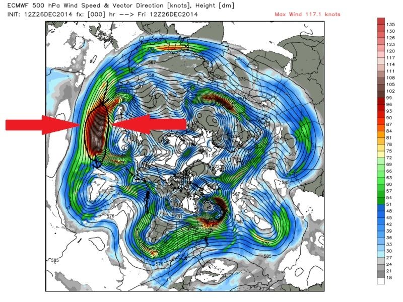
![]() by Frank_Wx Fri Dec 26, 2014 2:57 pm
by Frank_Wx Fri Dec 26, 2014 2:57 pm
In my opinion, if you want to salvage winter I would use the models to look at the H2 and H5 levels in the Pacific. Forget the Atlantic, because blocking is not going to come until a successful SSWE takes place and that may not happen.
Attached Images

_________________
_______________________________________________________________________________________________________
CLICK HERE to view NJ Strong Snowstorm Classifications
Frank_Wx- Godzilla Seeker
- Posts : 21305
Reputation : 328
Join date : 2013-01-05
Age : 31
Location : Jersey City, NJ -
Re: Official Long Range Thread 5.0
![]() by HectorO Fri Dec 26, 2014 3:37 pm
by HectorO Fri Dec 26, 2014 3:37 pm

HectorO- Pro Enthusiast

- Posts : 959
Reputation : 27
Join date : 2013-01-11
Page 17 of 40 • 1 ... 10 ... 16, 17, 18 ... 28 ... 40 ![]()
|
|
|