
 Search
Official Long Range Thread 5.0
Page 35 of 40 •  1 ... 19 ... 34, 35, 36 ... 40
 ![]()
Re: Official Long Range Thread 5.0
![]() by sroc4 Sun Jan 11, 2015 9:04 am
by sroc4 Sun Jan 11, 2015 9:04 am
With regards to the rest of the winter I am still standing firm on the time frame after Jan 20th for the first signs of our -NAO and consequently our first real chance for significant snowfall. Prob more like after the 25th. I know I know you all might be thinking just another patiently waiting for the LR to change our pattern. I don't blame you, and to be honest it might pan out like that, but I don't think so. If you don't believe me here is Larry Cosgroves latest update on his medium and long range thoughts:
"While neither large in scope or well-organized, a storm taking shape below Galveston TX may be creating a share of weather-related problems during the next 48 hours on its way into coastal New England. This disturbance has an ample moisture fetch from both the equatorial Pacific Ocean and the Bay of Campeche, and will be riding along a surge of warm advection with a southwest flow at 500MB.
Rain now organizing in Texas will expand north and east, encountering colder air over parts of the Ohio and Tennessee Valleys into Appalachia and the Mid-Atlantic/New England states. While the Deep South may see some stronger thunderstorms, instability is marginal so multiple cases of severe weather in Dixie seem unlikely to occur. Because the strongest surge of vertical motion will be along the division between a milder (rain favoring) atmosphere and a colder (snow and ice possibilities) regime, there seems to me to be a sizable risk of travel difficulties in the cold sector of the impulse. Roughly north of a line from Rogers AR....Louisville KY....Bluefield WV....Frederick MD....Norristown PA....Union NJ....Norwalk CT....Providence RI....Waltham MA....Portsmouth NH, precipitation types will gradate from liquid to frozen. The implication is for a significant icing event in the suburbs of the Interstate 95 corridor from Washington DC to Portland ME on Sunday night and Monday. Important snow accumulations will mostly occur in elevated sections of WV....W MD....PA....C, S NY....N CT....W, C MA....S VT....S NH and ME before the system exits the U.S. east of Cape Cod MA on Monday night.
At that point, the next in a series of Arctic intrusions will take control of the Midwest and then the Northeast behind the storm. Unlike the previous cAk domains, this parcel of air will be somewhat moderated.
The ridge which has persisted over the West seems weakened now. A series of disturbances from the eastern Pacific Ocean have reduced atmospheric heights and allowed cloud formations and precipitation to infiltrate the West Coast and Intermountain Region. And while it is highly possible that a slow-moving 500MB low may trigger mountain snow and lower elevation rain and thunder to the Desert Southwest on Sunday, most of next week shapes up dry from to the left of the High Plains. The -EPO signature will still stretch from Alaska to west of Baja California on Tuesday, deflecting the storm complex situated below the Aleutian Islands.
It would appear that the risk for a significant winter storm during the middle and late portion of the new week has ended. None of the computer schemes show a prominent precipitation output after Tuesday morning. Instead, a brief cold intrusion from the Great Lakes to the Eastern Seaboard is erased next weekend, beginning what appears to be a delayed version of the January Thaw.
Due to the delays in seeing moderation (I though that the January Thaw would occur in the U.S. between January 10 - 19, but the warming may be marginal and inconsistent), questions are being raised whether the nation sees a relaxation in readings at all. Yes, the various equations are in agreement on a strong rise in temperature across much of the continent during the course of the 6 - 10 day period. But if you review the 12z and 18z model runs (operational ECMWF and GFS in particular), you can see room for doubt. The European panels, long a stalwart in showing a big warming trend (and being mostly wrong in that process, I might add....) is already introducing higher 500MB heights in western Canada with some U.S. cold advection on January 20. It may well be that the Thaw will be weaker than in previous analogs, and likely to exit at some point in the 11 - 15 day time frame.
The rundown on the winter of 2014-15 goes like this: we are under a weak El Nino, which may work into moderate range in the ENSO 3.4 sector before easing in March. A lingering +PDO signal (warm layer along the Pacific coastline form Alaska to Baja California) appears to be aiding continued development of a -EPO signature with occasional -AO and -NAO linkages (hence the big cold intrusions in November and January). Perhaps most significant is that tropical forcing is feeding formation of two critical features: a sub-Aleutian mAk vortex and a southern branch jet stream across Mexico into the western Atlantic Ocean. One favors chances for cAk intrusions east of the Continental Divide, the other potential for major winter storms along the Gulf Coast, Appalachia, and Eastern Seaboard.
It is a matter of patience for when residents of the Midwest or East Coast will see a big snow or ice event. Weather is often a chance mix of ingredients, and it would appear that the U.S. has the entire spread of puzzle pieces for something memorable, if not dangerous, in the way of wintry conditions. The recent Arctic blast is an example of what this winter, in a collective sense, could turn out to be. But we have to get through the warming part of the 6 - 10 and early 11- 15 day periods before we can read new chapters about this season.
You may have read in some corners about the stratospheric warming event and the Madden-Julian Oscillation impacts on weather. Be warned that prediction of both these events and potential surface effects of same are not very well defined, or understood. There is a vast amount of warmer reflection far above the Arctic Circle, but as of yet not much lower atmospheric reflection. Cold vortices are in retreat for now. The MJO is very impressive, edging eastward from a Phase 6 and 7 position, and clearly linked to the polar westerlies. That would seem to favor a fairly cold turn in most of North America between January.
As I see it, the longer term forecast starts off as being mild for most of the nation (though I still have concerns for the colder hints posed by the operational ECMWF and parallel GFS series). The rebuilding of the big Alaskan block should return by January 21, and the full effects downstream will get underway by January 23. This includes a sizable threat for a Colorado/Trinidad (A) storm, with snow possibilities in the Great Plains into the Great Lakes and St. Lawrence Valleys. A cold surge should be relatively complete east of the Rocky Mountains by January 26, with perhaps another impressive disturbance showing up in Mexico and Texas around January 25.
When I look at the February analog charts, I smile broadly. And if you like "real" winter weather...you will too"
sroc4- Admin

- Posts : 8331
Join date : 2013-01-07
Re: Official Long Range Thread 5.0
![]() by Guest Sun Jan 11, 2015 9:36 am
by Guest Sun Jan 11, 2015 9:36 am
Guest- Guest
Re: Official Long Range Thread 5.0
![]() by sroc4 Sun Jan 11, 2015 10:38 am
by sroc4 Sun Jan 11, 2015 10:38 am
syosnow94 wrote:sroc4 wasn't at the get together so he doesn't understand that we banned the word patience!!!
I didn't see the official banned word list yet so Ill continue to use it.
_________________
"In weather and in life, there's no winning and losing; there's only winning and learning."
WINTER 2012/2013 TOTALS 43.65"WINTER 2017/2018 TOTALS 62.85" WINTER 2022/2023 TOTALS 4.9"
WINTER 2013/2014 TOTALS 64.85"WINTER 2018/2019 TOTALS 14.25" WINTER 2023/2024 TOTALS 13.1"
WINTER 2014/2015 TOTALS 71.20"WINTER 2019/2020 TOTALS 6.35"
WINTER 2015/2016 TOTALS 35.00"WINTER 2020/2021 TOTALS 37.75"
WINTER 2016/2017 TOTALS 42.25"WINTER 2021/2022 TOTALS 31.65"

sroc4- Admin
- Posts : 8331
Reputation : 301
Join date : 2013-01-07
Location : Wading River, LI
Re: Official Long Range Thread 5.0
![]() by Frank_Wx Sun Jan 11, 2015 10:42 am
by Frank_Wx Sun Jan 11, 2015 10:42 am
NO WE'RE NOT
_________________
_______________________________________________________________________________________________________
CLICK HERE to view NJ Strong Snowstorm Classifications

Frank_Wx- Godzilla Seeker
- Posts : 21305
Reputation : 328
Join date : 2013-01-05
Age : 31
Location : Jersey City, NJ -

Re: Official Long Range Thread 5.0
![]() by algae888 Sun Jan 11, 2015 12:29 pm
by algae888 Sun Jan 11, 2015 12:29 pm

algae888- Advanced Forecaster

- Posts : 5311
Reputation : 46
Join date : 2013-02-05
Age : 61
Location : mt. vernon, new york
Re: Official Long Range Thread 5.0
![]() by algae888 Sun Jan 11, 2015 2:49 pm
by algae888 Sun Jan 11, 2015 2:49 pm

stamp 3 and 6 are the hits
algae888- Advanced Forecaster
- Posts : 5311
Reputation : 46
Join date : 2013-02-05
Age : 61
Location : mt. vernon, new york
Re: Official Long Range Thread 5.0
![]() by sroc4 Sun Jan 11, 2015 3:12 pm
by sroc4 Sun Jan 11, 2015 3:12 pm
Frank_Wx wrote:When will forecasters such as LC stop saying we are in a weak El Nino?
NO WE'RE NOT
http://www.aer.com/science-research/climate-weather/arctic-oscillation
How about Judah Cohen, Ph.D., and Jason Furtado, Ph.D?? Just because there are other atmospheric influences causing this weak el nino to not have the usual influences doesn't mean its not there.
"Weak Central Pacific El Niño conditions persist (at least in the ocean – atmospheric coupling has been indiscernible with this event) with a positive PDO-like sea surface temperature (SST) pattern in the North Pacific (Figure 6)."
 " />
" />_________________
"In weather and in life, there's no winning and losing; there's only winning and learning."
WINTER 2012/2013 TOTALS 43.65"WINTER 2017/2018 TOTALS 62.85" WINTER 2022/2023 TOTALS 4.9"
WINTER 2013/2014 TOTALS 64.85"WINTER 2018/2019 TOTALS 14.25" WINTER 2023/2024 TOTALS 13.1"
WINTER 2014/2015 TOTALS 71.20"WINTER 2019/2020 TOTALS 6.35"
WINTER 2015/2016 TOTALS 35.00"WINTER 2020/2021 TOTALS 37.75"
WINTER 2016/2017 TOTALS 42.25"WINTER 2021/2022 TOTALS 31.65"
sroc4- Admin
- Posts : 8331
Reputation : 301
Join date : 2013-01-07
Location : Wading River, LI
Re: Official Long Range Thread 5.0
![]() by Frank_Wx Sun Jan 11, 2015 4:23 pm
by Frank_Wx Sun Jan 11, 2015 4:23 pm
sroc4 wrote:Frank_Wx wrote:When will forecasters such as LC stop saying we are in a weak El Nino?
NO WE'RE NOT
http://www.aer.com/science-research/climate-weather/arctic-oscillation
How about Judah Cohen, Ph.D., and Jason Furtado, Ph.D?? Just because there are other atmospheric influences causing this weak el nino to not have the usual influences doesn't mean its not there.
"Weak Central Pacific El Niño conditions persist (at least in the ocean – atmospheric coupling has been indiscernible with this event) with a positive PDO-like sea surface temperature (SST) pattern in the North Pacific (Figure 6)."
If the atmopshere is not reaponding, you can not declare the ENSO to be an El Nino (or LA Nina). If you read NOAAs ENSO weekly update, you'll notice they say "ENSO neutral conditions continue"
I can't post a link on mobile but just search "enso update" on Google and it should be the first link. It should be in pdf form.
Yes, conditions have met weak Nino criteria, but that doesn't matter. Certainly is not helping our weather pattern.
_________________
_______________________________________________________________________________________________________
CLICK HERE to view NJ Strong Snowstorm Classifications
Frank_Wx- Godzilla Seeker
- Posts : 21305
Reputation : 328
Join date : 2013-01-05
Age : 31
Location : Jersey City, NJ -
Re: Official Long Range Thread 5.0
![]() by Frank_Wx Sun Jan 11, 2015 4:43 pm
by Frank_Wx Sun Jan 11, 2015 4:43 pm
The GEFS and EURO suggest the MJO will propagate into the favorable phases of 7-8 by the end of next week.
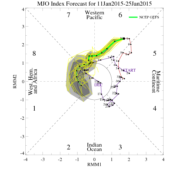
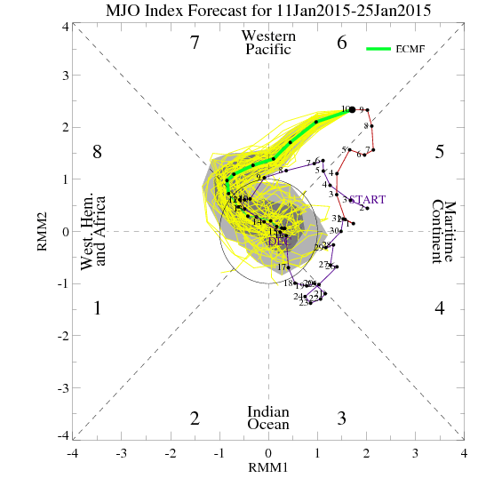
The GEFS seem to be having better verification when it comes to the MJO. The EURO is struggling with the current convection over the Philippines hence why you're seeing the back and forth with either the MJO going into the COD or advancing into phase 7.
Keep an eye on the Dateline with the next 2 graphics.
January 1st:

January 10th:
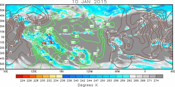
The convection has not moved much over the last 10 days, but it's making progress. Once it gets just east of the dateline..we should see a ridge building i to the western US.

The latest GEFS look very yummy in the long range. We can only hope they have the right idea. They've performed much better than the euro ens this winter. If the MJO does get to phase 7 and the current 10mb Stratospheric warming comes to fruition....we'll be in our most favorable pattern yet
_________________
_______________________________________________________________________________________________________
CLICK HERE to view NJ Strong Snowstorm Classifications
Frank_Wx- Godzilla Seeker
- Posts : 21305
Reputation : 328
Join date : 2013-01-05
Age : 31
Location : Jersey City, NJ -
Re: Official Long Range Thread 5.0
![]() by sroc4 Sun Jan 11, 2015 4:55 pm
by sroc4 Sun Jan 11, 2015 4:55 pm
_________________
"In weather and in life, there's no winning and losing; there's only winning and learning."
WINTER 2012/2013 TOTALS 43.65"WINTER 2017/2018 TOTALS 62.85" WINTER 2022/2023 TOTALS 4.9"
WINTER 2013/2014 TOTALS 64.85"WINTER 2018/2019 TOTALS 14.25" WINTER 2023/2024 TOTALS 13.1"
WINTER 2014/2015 TOTALS 71.20"WINTER 2019/2020 TOTALS 6.35"
WINTER 2015/2016 TOTALS 35.00"WINTER 2020/2021 TOTALS 37.75"
WINTER 2016/2017 TOTALS 42.25"WINTER 2021/2022 TOTALS 31.65"
sroc4- Admin
- Posts : 8331
Reputation : 301
Join date : 2013-01-07
Location : Wading River, LI
Re: Official Long Range Thread 5.0
![]() by sroc4 Sun Jan 11, 2015 4:58 pm
by sroc4 Sun Jan 11, 2015 4:58 pm
Frank_Wx wrote:Signal every day continues to go stronger that by the end of this month or early February, a -EPO/-AO/-NAO trifecta will develop. I'm not trying to hype a pattern change...I said the first 10 days of January will be below normal and the middle of the month will feature some moderation. I've been calling it like I see it since my updated winter outlook. But I can't help but like what I'm seeing by the 25th or so of January.
The GEFS and EURO suggest the MJO will propagate into the favorable phases of 7-8 by the end of next week.
The GEFS seem to be having better verification when it comes to the MJO. The EURO is struggling with the current convection over the Philippines hence why you're seeing the back and forth with either the MJO going into the COD or advancing into phase 7.
Keep an eye on the Dateline with the next 2 graphics.
January 1st:
January 10th:
The convection has not moved much over the last 10 days, but it's making progress. Once it gets just east of the dateline..we should see a ridge building i to the western US.
The latest GEFS look very yummy in the long range. We can only hope they have the right idea. They've performed much better than the euro ens this winter. If the MJO does get to phase 7 and the current 10mb Stratospheric warming comes to fruition....we'll be in our most favorable pattern yet
I am 100% with you on this point Frank. In my blog on my first case study I have talked about a similar time frame. I was thinking maybe a few days earlier than you but the same idea. And BTW I don't mean to be argumentative with the El Nino point. It just seems like a potato Po-TA-toe kind of thing. There seems to be prominent mets on both sides of that argument
_________________
"In weather and in life, there's no winning and losing; there's only winning and learning."
WINTER 2012/2013 TOTALS 43.65"WINTER 2017/2018 TOTALS 62.85" WINTER 2022/2023 TOTALS 4.9"
WINTER 2013/2014 TOTALS 64.85"WINTER 2018/2019 TOTALS 14.25" WINTER 2023/2024 TOTALS 13.1"
WINTER 2014/2015 TOTALS 71.20"WINTER 2019/2020 TOTALS 6.35"
WINTER 2015/2016 TOTALS 35.00"WINTER 2020/2021 TOTALS 37.75"
WINTER 2016/2017 TOTALS 42.25"WINTER 2021/2022 TOTALS 31.65"
sroc4- Admin
- Posts : 8331
Reputation : 301
Join date : 2013-01-07
Location : Wading River, LI
Re: Official Long Range Thread 5.0
![]() by Frank_Wx Sun Jan 11, 2015 5:02 pm
by Frank_Wx Sun Jan 11, 2015 5:02 pm
sroc4 wrote:I don't know Frank. It sounds like semantics. Its like when they said Sandy wasn't a hurricane because it wasn't warm core. There is no denying the Tropical forcing has not responded typical to a weak west or central based El Nino, but SST anomalies in the western and central Eq Pac since Oct 1st being above criteria of > than or = to 0.5*for > 3 months.
I think I'll side with NOAA on this one. Once they declare this El Nino, I'll be glad to say we're in one. Heres their discussion
http://www.climate.gov/news-features/blogs/enso/january-enso-update-little-engine-couldnt-quite
_________________
_______________________________________________________________________________________________________
CLICK HERE to view NJ Strong Snowstorm Classifications
Frank_Wx- Godzilla Seeker
- Posts : 21305
Reputation : 328
Join date : 2013-01-05
Age : 31
Location : Jersey City, NJ -
Re: Official Long Range Thread 5.0
![]() by Frank_Wx Sun Jan 11, 2015 5:04 pm
by Frank_Wx Sun Jan 11, 2015 5:04 pm
sroc4 wrote:Frank_Wx wrote:Signal every day continues to go stronger that by the end of this month or early February, a -EPO/-AO/-NAO trifecta will develop. I'm not trying to hype a pattern change...I said the first 10 days of January will be below normal and the middle of the month will feature some moderation. I've been calling it like I see it since my updated winter outlook. But I can't help but like what I'm seeing by the 25th or so of January.
The GEFS and EURO suggest the MJO will propagate into the favorable phases of 7-8 by the end of next week.
The GEFS seem to be having better verification when it comes to the MJO. The EURO is struggling with the current convection over the Philippines hence why you're seeing the back and forth with either the MJO going into the COD or advancing into phase 7.
Keep an eye on the Dateline with the next 2 graphics.
January 1st:
January 10th:
The convection has not moved much over the last 10 days, but it's making progress. Once it gets just east of the dateline..we should see a ridge building i to the western US.
The latest GEFS look very yummy in the long range. We can only hope they have the right idea. They've performed much better than the euro ens this winter. If the MJO does get to phase 7 and the current 10mb Stratospheric warming comes to fruition....we'll be in our most favorable pattern yet
I am 100% with you on this point Frank. In my blog on my first case study I have talked about a similar time frame. I was thinking maybe a few days earlier than you but the same idea. And BTW I don't mean to be argumentative with the El Nino point. It just seems like a potato Po-TA-toe kind of thing. There seems to be prominent mets on both sides of that argument
Don't sweat it. Check out the link I posted. I'm not disagreeing with you that current SSTs don't support El nino, but technically you can't declare it one until the weather responds at the surface.
_________________
_______________________________________________________________________________________________________
CLICK HERE to view NJ Strong Snowstorm Classifications
Frank_Wx- Godzilla Seeker
- Posts : 21305
Reputation : 328
Join date : 2013-01-05
Age : 31
Location : Jersey City, NJ -
Re: Official Long Range Thread 5.0
![]() by Frank_Wx Sun Jan 11, 2015 5:33 pm
by Frank_Wx Sun Jan 11, 2015 5:33 pm
_________________
_______________________________________________________________________________________________________
CLICK HERE to view NJ Strong Snowstorm Classifications
Frank_Wx- Godzilla Seeker
- Posts : 21305
Reputation : 328
Join date : 2013-01-05
Age : 31
Location : Jersey City, NJ -
Re: Official Long Range Thread 5.0
![]() by jmanley32 Sun Jan 11, 2015 8:07 pm
by jmanley32 Sun Jan 11, 2015 8:07 pm

jmanley32- Senior Enthusiast

- Posts : 20516
Reputation : 108
Join date : 2013-12-12
Age : 42
Location : Yonkers, NY
Re: Official Long Range Thread 5.0
![]() by Frank_Wx Sun Jan 11, 2015 8:40 pm
by Frank_Wx Sun Jan 11, 2015 8:40 pm
jmanley32 wrote:Long range out to 240 showing another friggin cutter. Sigh, it looks somewhat cold though, do cutters ever give us snow? With the new GS tomorrow, will it go out to 240 from now on or 192?
I highly encourage people the next 2 weeks to take a break and return after the 23rd.
_________________
_______________________________________________________________________________________________________
CLICK HERE to view NJ Strong Snowstorm Classifications
Frank_Wx- Godzilla Seeker
- Posts : 21305
Reputation : 328
Join date : 2013-01-05
Age : 31
Location : Jersey City, NJ -
Re: Official Long Range Thread 5.0
![]() by Dunnzoo Sun Jan 11, 2015 8:42 pm
by Dunnzoo Sun Jan 11, 2015 8:42 pm
Frank_Wx wrote:jmanley32 wrote:Long range out to 240 showing another friggin cutter. Sigh, it looks somewhat cold though, do cutters ever give us snow? With the new GS tomorrow, will it go out to 240 from now on or 192?
I highly encourage people the next 2 weeks to take a break and return after the 23rd.
Maybe after tomorrow's event
_________________
Janet
Snowfall winter of 2023-2024 17.5"
Snowfall winter of 2022-2023 6.0"
Snowfall winter of 2021-2022 17.6" 1" sleet 2/25/22
Snowfall winter of 2020-2021 51.1"
Snowfall winter of 2019-2020 8.5"
Snowfall winter of 2018-2019 25.1"
Snowfall winter of 2017-2018 51.9"
Snowfall winter of 2016-2017 45.6"
Snowfall winter of 2015-2016 29.5"
Snowfall winter of 2014-2015 50.55"
Snowfall winter of 2013-2014 66.5"

Dunnzoo- Senior Enthusiast - Mod

- Posts : 4891
Reputation : 68
Join date : 2013-01-11
Age : 62
Location : Westwood, NJ
Re: Official Long Range Thread 5.0
![]() by SoulSingMG Mon Jan 12, 2015 2:02 am
by SoulSingMG Mon Jan 12, 2015 2:02 am

SoulSingMG- Senior Enthusiast
- Posts : 2853
Reputation : 74
Join date : 2013-12-11
Location : Long Island City, NY
Re: Official Long Range Thread 5.0
![]() by Guest Mon Jan 12, 2015 9:27 am
by Guest Mon Jan 12, 2015 9:27 am
SoulSingMG wrote:I wonder when the last year of no storms >3" snow happened in New York City...... .....
I KNOW WHEN THE NEXT ONE IS!!!!!!!!
Guest- Guest
Re: Official Long Range Thread 5.0
![]() by CPcantmeasuresnow Mon Jan 12, 2015 9:53 am
by CPcantmeasuresnow Mon Jan 12, 2015 9:53 am
syosnow94 wrote:SoulSingMG wrote:I wonder when the last year of no storms >3" snow happened in New York City...... .....
I KNOW WHEN THE NEXT ONE IS!!!!!!!!
Your definitely need a five day break from this god awful winter syos. If you'd like I will put in a good word for you with the Director of Tourism on OTI , ex king mugs, and see if he will grant you a five day visa.

CPcantmeasuresnow- Wx Statistician Guru

- Posts : 7274
Reputation : 230
Join date : 2013-01-07
Age : 103
Location : Eastern Orange County, NY
Re: Official Long Range Thread 5.0
![]() by jmanley32 Mon Jan 12, 2015 10:15 am
by jmanley32 Mon Jan 12, 2015 10:15 am
jmanley32- Senior Enthusiast
- Posts : 20516
Reputation : 108
Join date : 2013-12-12
Age : 42
Location : Yonkers, NY
Re: Official Long Range Thread 5.0
![]() by amugs Mon Jan 12, 2015 10:29 am
by amugs Mon Jan 12, 2015 10:29 am

_________________
Mugs
AKA:King: Snow Weenie
Self Proclaimed
WINTER 2014-15 : 55.12" +.02 for 6 coatings (avg. 35")
WINTER 2015-16 Total - 29.8" (Avg 35")
WINTER 2016-17 : 39.5" so far

amugs- Advanced Forecaster - Mod
- Posts : 15093
Reputation : 213
Join date : 2013-01-07
Age : 54
Location : Hillsdale,NJ
Re: Official Long Range Thread 5.0
![]() by amugs Mon Jan 12, 2015 10:32 am
by amugs Mon Jan 12, 2015 10:32 am
Earlier this month, I posted about the potential for an AO modality reversal in late January, particularly by the 20th and thereafter, as a more Nino-like global pattern begins to develop. I continue to believe that should be the case for a number of reasons as outlined below. The NAO state is more uncertain; however, there should be a significant improvement w/ a neutralization of the index by late January, which would certainly be a far cry from the strongly positive / low height field dominating the north Atlantic so far this winter.
[1] Pacific-tropical forcing: A major "problem" over the past several months has been a lack of real Nino-like tropical forcing in the Pacific. SST's have gradually warmed to weak El Nino criteria, and the SSTA profile is indicative of a strongly positive PDO signal; however, tropical convection has been more reminiscent of a La Nina pattern, and this had has implications as far as the mid-latitude regime. As noted before, this will be changing as we finally see an eastward propagation of tropical convection / upward motion into the central tropical Pacific, which should initiate downstream changes in the mid latitude 500mb pattern.
Note the tendency for suppressed convection over the central tropical Pacific over the past several months. Forecasts for the next few weeks indicate a significant change to this tropical forcing pattern as stronger upward motion / lift translates ewd.

200mb velocity potential and OLR forecasts suggest that the above tendency persists throughout the remainder of January.

[2] Global budget of atmospheric angular momentum: An important indicator of whether the atmosphere is in a Nino or Nina-like state is the AAM budget of Earth, namely is AAM increasing or decreasing, particularly in the tropical regions, which has significant ramifications as far as the mid latitude ridge / trough response. Lower AAM tendency represents a more Nina-like state while increasing speeds suggest a more Nino-like state. If one notes prior Nino winters, generally one finds that a Nina-like pattern occurs more frequently in Nino's when the AAM budget is suppressed. However, the Nino's which feature increased AAM tend to resemble more closely a "typical" El Nino height configuration at 500mb. This is a relationship that exists which must be utilized in concert with all other variables as well. November-early December featured a predominately +AAM, during which time, high latitude blocking and Eastern troughiness was present. That reversed to a strongly negative AAM by mid December, at which time a +EPO / +AO regime initiated. Currently, AAM has spiked significantly, at levels higher than we've seen over the past 50-60 days. This seems to coincide with the development of more Nino-like tropical forcing.
[3] Stratospheric improvement: The minor SSW event which transpired last week significantly warmed the stratosphere and can often act to warm / perturb the tropospheric vortex, thereby reversing the modality of the northern annular mode. This process tends to take at least 2 weeks, which further points to the 20th and beyond time frame I've been referencing for an AO state shift. We may not initially see a strongly negative AO, but the AO should neutralize by the 20th, then turn negative for the final 10 days of January as heights build across the pole from both the Eurasian and Pacific sides. The NAO state will likely lag due to the maintenance of a stratospheric vortex near Greenland and recent enhanced geomagnetic activity; however, it should undergo a significant negative trend toward neutral at the very least by late January. Model guidance is now in agreement on height rises beginning first in the EPO region by the 19th, and the Arctic after the 20th. Heights should improve significantly in the NAO region, but I wouldn't expect a monster Greenland block this month.
[4] ENSO state / progression analogs: the tendency in warm/positive ENSO years is for a mid to late winter negative AO / NAO state. Even in warm ENSO positive winters, the NAO often shifted to a negative state for February.
In conclusion: the current cold January has clearly diverted this winter from poor/warm +ENSO year and indicates that the global state remains favorable for NPAC / EPO blocking, as has been the case since autumn. Improvements in global, tropical, and stratospheric forcing implicate an AO shift after the 20th. The NAO state should improve significantly (neutralize) but blocking in that region may remain unimpressive for the time being. Sensible weather wise: anticipate a transient thaw period of approximately 3-5 days as the global regime transitions, however, the cold January should resume for the CONUS by the last week of January, with the development of a -EPO/-AO. Since the negative AO state has not been present thus far, this will likely increase the potential for wintry precipitation in the East which has largely been absent. At this point, I expect the late January transition to continue and amplify for the month of February. We'll see how it goes.
_________________
Mugs
AKA:King: Snow Weenie
Self Proclaimed
WINTER 2014-15 : 55.12" +.02 for 6 coatings (avg. 35")
WINTER 2015-16 Total - 29.8" (Avg 35")
WINTER 2016-17 : 39.5" so far
amugs- Advanced Forecaster - Mod
- Posts : 15093
Reputation : 213
Join date : 2013-01-07
Age : 54
Location : Hillsdale,NJ
Re: Official Long Range Thread 5.0
![]() by down tines Mon Jan 12, 2015 11:28 am
by down tines Mon Jan 12, 2015 11:28 am

down tines- Posts : 39
Reputation : 0
Join date : 2013-01-24
Location : Allentown N.J.
Re: Official Long Range Thread 5.0
![]() by Frank_Wx Mon Jan 12, 2015 11:36 am
by Frank_Wx Mon Jan 12, 2015 11:36 am
down tines wrote:Just a quick question nws has me in central jersey at 20% chance of snow for this Wednesday and Wednesday night,im going on vacation Wednesday morning I plow for the state is there any chance this will be a plowable snow, say 2 inches thanks in advance
No
_________________
_______________________________________________________________________________________________________
CLICK HERE to view NJ Strong Snowstorm Classifications
Frank_Wx- Godzilla Seeker
- Posts : 21305
Reputation : 328
Join date : 2013-01-05
Age : 31
Location : Jersey City, NJ -
Re: Official Long Range Thread 5.0
![]() by down tines Mon Jan 12, 2015 11:46 am
by down tines Mon Jan 12, 2015 11:46 am
down tines- Posts : 39
Reputation : 0
Join date : 2013-01-24
Location : Allentown N.J.
Re: Official Long Range Thread 5.0
![]() by Frank_Wx Mon Jan 12, 2015 11:50 am
by Frank_Wx Mon Jan 12, 2015 11:50 am
down tines wrote:Thanks Frank,I troll the sight all the time.
No problem!
_________________
_______________________________________________________________________________________________________
CLICK HERE to view NJ Strong Snowstorm Classifications
Frank_Wx- Godzilla Seeker
- Posts : 21305
Reputation : 328
Join date : 2013-01-05
Age : 31
Location : Jersey City, NJ -
Page 35 of 40 • 1 ... 19 ... 34, 35, 36 ... 40 ![]()
|
|
|