
 Search
Hybrid / Sub-Tropical Storm Possible Sunday-Monday (UNCERTAINTY)
Page 20 of 40 •  1 ... 11 ... 19, 20, 21 ... 30 ... 40
 ![]()
Re: Hybrid / Sub-Tropical Storm Possible Sunday-Monday (UNCERTAINTY)
![]() by Frank_Wx Tue Sep 29, 2015 10:07 pm
by Frank_Wx Tue Sep 29, 2015 10:07 pm
https://youtu.be/CKrBRWjaJ0E
Frank_Wx- Godzilla Seeker

- Posts : 21305
Join date : 2013-01-05 -

Re: Hybrid / Sub-Tropical Storm Possible Sunday-Monday (UNCERTAINTY)
![]() by jmanley32 Tue Sep 29, 2015 10:25 pm
by jmanley32 Tue Sep 29, 2015 10:25 pm
jmanley32- Senior Enthusiast

- Posts : 20513
Join date : 2013-12-12
Re: Hybrid / Sub-Tropical Storm Possible Sunday-Monday (UNCERTAINTY)
![]() by snow247 Tue Sep 29, 2015 10:28 pm
by snow247 Tue Sep 29, 2015 10:28 pm

snow247- Pro Enthusiast

- Posts : 2417
Reputation : 0
Join date : 2014-08-27
Location : Mount Ivy, NY - Elevation 545'
Re: Hybrid / Sub-Tropical Storm Possible Sunday-Monday (UNCERTAINTY)
![]() by jmanley32 Tue Sep 29, 2015 10:32 pm
by jmanley32 Tue Sep 29, 2015 10:32 pm
snow247 wrote:
what ensembles are those? OTS seems out of here.

jmanley32- Senior Enthusiast
- Posts : 20513
Reputation : 108
Join date : 2013-12-12
Age : 42
Location : Yonkers, NY
Re: Hybrid / Sub-Tropical Storm Possible Sunday-Monday (UNCERTAINTY)
![]() by jmanley32 Tue Sep 29, 2015 10:33 pm
by jmanley32 Tue Sep 29, 2015 10:33 pm
jmanley32- Senior Enthusiast
- Posts : 20513
Reputation : 108
Join date : 2013-12-12
Age : 42
Location : Yonkers, NY
Re: Hybrid / Sub-Tropical Storm Possible Sunday-Monday (UNCERTAINTY)
![]() by jmanley32 Tue Sep 29, 2015 10:57 pm
by jmanley32 Tue Sep 29, 2015 10:57 pm
jmanley32- Senior Enthusiast
- Posts : 20513
Reputation : 108
Join date : 2013-12-12
Age : 42
Location : Yonkers, NY
Re: Hybrid / Sub-Tropical Storm Possible Sunday-Monday (UNCERTAINTY)
![]() by Frank_Wx Tue Sep 29, 2015 10:58 pm
by Frank_Wx Tue Sep 29, 2015 10:58 pm
_________________
_______________________________________________________________________________________________________
CLICK HERE to view NJ Strong Snowstorm Classifications

Frank_Wx- Godzilla Seeker
- Posts : 21305
Reputation : 328
Join date : 2013-01-05
Age : 31
Location : Jersey City, NJ -
Re: Hybrid / Sub-Tropical Storm Possible Sunday-Monday (UNCERTAINTY)
![]() by jmanley32 Tue Sep 29, 2015 10:59 pm
by jmanley32 Tue Sep 29, 2015 10:59 pm
jmanley32- Senior Enthusiast
- Posts : 20513
Reputation : 108
Join date : 2013-12-12
Age : 42
Location : Yonkers, NY
Re: Hybrid / Sub-Tropical Storm Possible Sunday-Monday (UNCERTAINTY)
![]() by jmanley32 Tue Sep 29, 2015 11:00 pm
by jmanley32 Tue Sep 29, 2015 11:00 pm
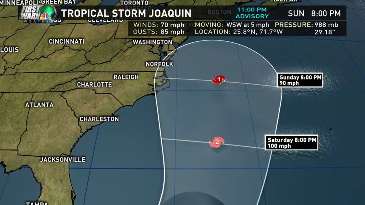
Frank_Wx wrote:11pm Track is showing a slight bend toward the coast. Will be a hurricane by the morning.
on a beeline thats enough to make landfall right around here, likely will still change though, has to be a hurricane by 5am. I would be surprised if not. Good thing you didnt really bet.
jmanley32- Senior Enthusiast
- Posts : 20513
Reputation : 108
Join date : 2013-12-12
Age : 42
Location : Yonkers, NY
Re: Hybrid / Sub-Tropical Storm Possible Sunday-Monday (UNCERTAINTY)
![]() by jmanley32 Tue Sep 29, 2015 11:01 pm
by jmanley32 Tue Sep 29, 2015 11:01 pm
jmanley32- Senior Enthusiast
- Posts : 20513
Reputation : 108
Join date : 2013-12-12
Age : 42
Location : Yonkers, NY
Re: Hybrid / Sub-Tropical Storm Possible Sunday-Monday (UNCERTAINTY)
![]() by Guest Tue Sep 29, 2015 11:07 pm
by Guest Tue Sep 29, 2015 11:07 pm
jmanley32 wrote:On that track would be a late sunday night monday morning/day hurricane.
Jman!! On that track (and i know it will change) My house is dead center of the cone here in west/central LI. Me and Sroc get crushed.
Guest- Guest
Re: Hybrid / Sub-Tropical Storm Possible Sunday-Monday (UNCERTAINTY)
![]() by jmanley32 Tue Sep 29, 2015 11:09 pm
by jmanley32 Tue Sep 29, 2015 11:09 pm
jmanley32- Senior Enthusiast
- Posts : 20513
Reputation : 108
Join date : 2013-12-12
Age : 42
Location : Yonkers, NY
Re: Hybrid / Sub-Tropical Storm Possible Sunday-Monday (UNCERTAINTY)
![]() by Frank_Wx Tue Sep 29, 2015 11:11 pm
by Frank_Wx Tue Sep 29, 2015 11:11 pm
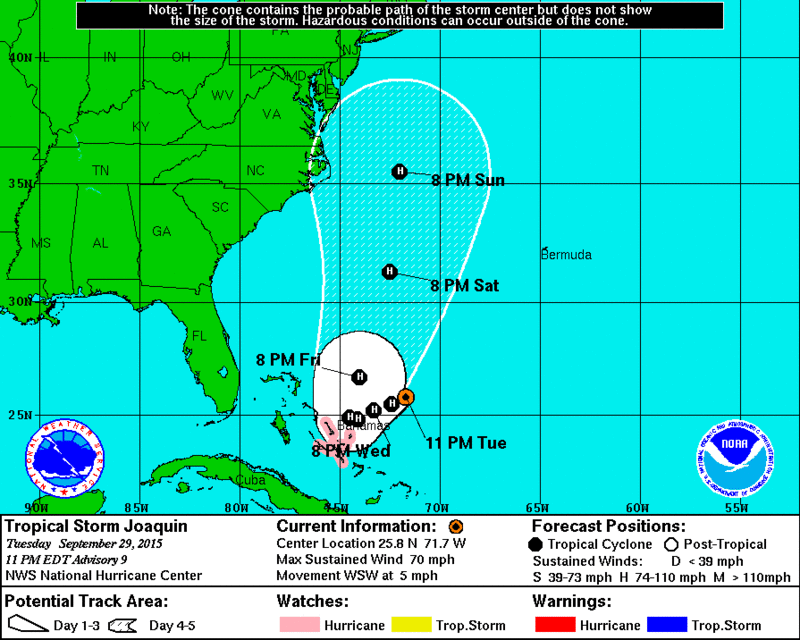
Home Public Adv Fcst Adv Discussion Wind Probs Graphics Archive
000
WTNT31 KNHC 300254
TCPAT1
BULLETIN
TROPICAL STORM JOAQUIN ADVISORY NUMBER 9
NWS NATIONAL HURRICANE CENTER MIAMI FL AL112015
1100 PM EDT TUE SEP 29 2015
...JOAQUIN EXPECTED TO BECOME A HURRICANE LATER TONIGHT OR
WEDNESDAY...
...HURRICANE WATCH ISSUED FOR THE CENTRAL BAHAMAS...
SUMMARY OF 1100 PM EDT...0300 UTC...INFORMATION
-----------------------------------------------
LOCATION...25.8N 71.7W
ABOUT 360 MI...580 KM E OF THE NORTHWESTERN BAHAMAS
MAXIMUM SUSTAINED WINDS...70 MPH...110 KM/H
PRESENT MOVEMENT...WSW OR 240 DEGREES AT 5 MPH...7 KM/H
MINIMUM CENTRAL PRESSURE...988 MB...29.18 INCHES
WATCHES AND WARNINGS
--------------------
CHANGES WITH THIS ADVISORY:
The government of the Bahamas as issued a Hurricane Watch for the
Central Bahamas.
SUMMARY OF WATCHES AND WARNINGS IN EFFECT:
A Hurricane Watch is in effect for...
* Central Bahamas
A Hurricane Watch means that hurricane conditions are possible
within the watch area, in this case within the next 36 to 48
hours.
Interests in the Northwest Bahamas should monitor the progress of
Joaquin. Additional watches or warnings may be required early
Wednesday.
For storm information specific to your area, please monitor
products issued by your national meteorological service.
DISCUSSION AND 48-HOUR OUTLOOK
------------------------------
At 1100 PM EDT (0300 UTC), the center of Tropical Storm Joaquin was
located near latitude 25.8 North, longitude 71.7 West. Joaquin is
moving toward the west-southwest near 5 mph (7 km/h) and this
general motion is expected to continue for the next couple of days.
On the forecast track, the center of Joaquin is expected to move
near or over portions of the central Bahamas Wednesday night or
Thursday.
Maximum sustained winds have increased to near 70 mph (110 km/h)
with higher gusts. Additional strengthening is expected during the
next 48 hours, and Joaquin is forecast to become a hurricane later
tonight or Wednesday.
Tropical-storm-force winds extend outward up to 125 miles (205 km),
mainly to the east of the center.
The estimated minimum central pressure is 988 mb (29.18 inches).
HAZARDS AFFECTING LAND
----------------------
WIND: Tropical storm conditions could reach portions of the Central
Bahamas by Wednesday night, with hurricane conditions possible by
late Wednesday night or early Thursday.
RAINFALL: Joaquin is expected to produce 4 to 8 inches of rain with
isolated maximum amounts of 12 inches possible over San Salvador and
Rum Cay through Thursday morning. Rainfall amounts of 3 to 5 inches
are possible over the remainder of the Central Bahamas through
Thursday morning, with 1 to 2 inches expected over the Northwest and
Southeast Bahamas.
SURF: Swells generated by Joaquin will affect portions of the
Bahamas during the next few days. These swells are likely to cause
life-threatening surf and rip current conditions. Please consult
products from your local weather office.
NEXT ADVISORY
-------------
Next intermediate advisory at 200 AM EDT.
Next complete advisory at 500 AM EDT.
_________________
_______________________________________________________________________________________________________
CLICK HERE to view NJ Strong Snowstorm Classifications
Frank_Wx- Godzilla Seeker
- Posts : 21305
Reputation : 328
Join date : 2013-01-05
Age : 31
Location : Jersey City, NJ -
Re: Hybrid / Sub-Tropical Storm Possible Sunday-Monday (UNCERTAINTY)
![]() by aiannone Tue Sep 29, 2015 11:13 pm
by aiannone Tue Sep 29, 2015 11:13 pm
syosnow94 wrote:jmanley32 wrote:On that track would be a late sunday night monday morning/day hurricane.
Jman!! On that track (and i know it will change) My house is dead center of the cone here in west/central LI. Me and Sroc get crushed.
Yea so am I chopped liver over here? Last time I checked there were more than 2 LIers here!!!!
_________________
-Alex Iannone-

aiannone- Senior Enthusiast - Mod

- Posts : 4813
Reputation : 92
Join date : 2013-01-07
Location : Saint James, LI (Northwest Suffolk Co.)
Re: Hybrid / Sub-Tropical Storm Possible Sunday-Monday (UNCERTAINTY)
![]() by aiannone Tue Sep 29, 2015 11:13 pm
by aiannone Tue Sep 29, 2015 11:13 pm
Frank_Wx wrote:opical Storm JOAQUIN Public Advisory
Home Public Adv Fcst Adv Discussion Wind Probs Graphics Archive
000
WTNT31 KNHC 300254
TCPAT1
BULLETIN
TROPICAL STORM JOAQUIN ADVISORY NUMBER 9
NWS NATIONAL HURRICANE CENTER MIAMI FL AL112015
1100 PM EDT TUE SEP 29 2015
...JOAQUIN EXPECTED TO BECOME A HURRICANE LATER TONIGHT OR
WEDNESDAY...
...HURRICANE WATCH ISSUED FOR THE CENTRAL BAHAMAS...
SUMMARY OF 1100 PM EDT...0300 UTC...INFORMATION
-----------------------------------------------
LOCATION...25.8N 71.7W
ABOUT 360 MI...580 KM E OF THE NORTHWESTERN BAHAMAS
MAXIMUM SUSTAINED WINDS...70 MPH...110 KM/H
PRESENT MOVEMENT...WSW OR 240 DEGREES AT 5 MPH...7 KM/H
MINIMUM CENTRAL PRESSURE...988 MB...29.18 INCHES
WATCHES AND WARNINGS
--------------------
CHANGES WITH THIS ADVISORY:
The government of the Bahamas as issued a Hurricane Watch for the
Central Bahamas.
SUMMARY OF WATCHES AND WARNINGS IN EFFECT:
A Hurricane Watch is in effect for...
* Central Bahamas
A Hurricane Watch means that hurricane conditions are possible
within the watch area, in this case within the next 36 to 48
hours.
Interests in the Northwest Bahamas should monitor the progress of
Joaquin. Additional watches or warnings may be required early
Wednesday.
For storm information specific to your area, please monitor
products issued by your national meteorological service.
DISCUSSION AND 48-HOUR OUTLOOK
------------------------------
At 1100 PM EDT (0300 UTC), the center of Tropical Storm Joaquin was
located near latitude 25.8 North, longitude 71.7 West. Joaquin is
moving toward the west-southwest near 5 mph (7 km/h) and this
general motion is expected to continue for the next couple of days.
On the forecast track, the center of Joaquin is expected to move
near or over portions of the central Bahamas Wednesday night or
Thursday.
Maximum sustained winds have increased to near 70 mph (110 km/h)
with higher gusts. Additional strengthening is expected during the
next 48 hours, and Joaquin is forecast to become a hurricane later
tonight or Wednesday.
Tropical-storm-force winds extend outward up to 125 miles (205 km),
mainly to the east of the center.
The estimated minimum central pressure is 988 mb (29.18 inches).
HAZARDS AFFECTING LAND
----------------------
WIND: Tropical storm conditions could reach portions of the Central
Bahamas by Wednesday night, with hurricane conditions possible by
late Wednesday night or early Thursday.
RAINFALL: Joaquin is expected to produce 4 to 8 inches of rain with
isolated maximum amounts of 12 inches possible over San Salvador and
Rum Cay through Thursday morning. Rainfall amounts of 3 to 5 inches
are possible over the remainder of the Central Bahamas through
Thursday morning, with 1 to 2 inches expected over the Northwest and
Southeast Bahamas.
SURF: Swells generated by Joaquin will affect portions of the
Bahamas during the next few days. These swells are likely to cause
life-threatening surf and rip current conditions. Please consult
products from your local weather office.
NEXT ADVISORY
-------------
Next intermediate advisory at 200 AM EDT.
Next complete advisory at 500 AM EDT.
Looks like they are now going to an advisory every 3hrs right?
_________________
-Alex Iannone-
aiannone- Senior Enthusiast - Mod
- Posts : 4813
Reputation : 92
Join date : 2013-01-07
Location : Saint James, LI (Northwest Suffolk Co.)
Re: Hybrid / Sub-Tropical Storm Possible Sunday-Monday (UNCERTAINTY)
![]() by snow247 Tue Sep 29, 2015 11:15 pm
by snow247 Tue Sep 29, 2015 11:15 pm
snow247- Pro Enthusiast
- Posts : 2417
Reputation : 0
Join date : 2014-08-27
Location : Mount Ivy, NY - Elevation 545'
Re: Hybrid / Sub-Tropical Storm Possible Sunday-Monday (UNCERTAINTY)
![]() by Frank_Wx Tue Sep 29, 2015 11:22 pm
by Frank_Wx Tue Sep 29, 2015 11:22 pm

_________________
_______________________________________________________________________________________________________
CLICK HERE to view NJ Strong Snowstorm Classifications
Frank_Wx- Godzilla Seeker
- Posts : 21305
Reputation : 328
Join date : 2013-01-05
Age : 31
Location : Jersey City, NJ -
Re: Hybrid / Sub-Tropical Storm Possible Sunday-Monday (UNCERTAINTY)
![]() by Frank_Wx Tue Sep 29, 2015 11:26 pm
by Frank_Wx Tue Sep 29, 2015 11:26 pm
_________________
_______________________________________________________________________________________________________
CLICK HERE to view NJ Strong Snowstorm Classifications
Frank_Wx- Godzilla Seeker
- Posts : 21305
Reputation : 328
Join date : 2013-01-05
Age : 31
Location : Jersey City, NJ -
Re: Hybrid / Sub-Tropical Storm Possible Sunday-Monday (UNCERTAINTY)
![]() by jmanley32 Tue Sep 29, 2015 11:26 pm
by jmanley32 Tue Sep 29, 2015 11:26 pm
jmanley32- Senior Enthusiast
- Posts : 20513
Reputation : 108
Join date : 2013-12-12
Age : 42
Location : Yonkers, NY
Re: Hybrid / Sub-Tropical Storm Possible Sunday-Monday (UNCERTAINTY)
![]() by Frank_Wx Tue Sep 29, 2015 11:27 pm
by Frank_Wx Tue Sep 29, 2015 11:27 pm
_________________
_______________________________________________________________________________________________________
CLICK HERE to view NJ Strong Snowstorm Classifications
Frank_Wx- Godzilla Seeker
- Posts : 21305
Reputation : 328
Join date : 2013-01-05
Age : 31
Location : Jersey City, NJ -
Re: Hybrid / Sub-Tropical Storm Possible Sunday-Monday (UNCERTAINTY)
![]() by jmanley32 Tue Sep 29, 2015 11:35 pm
by jmanley32 Tue Sep 29, 2015 11:35 pm
Frank_Wx wrote:RGEM would capture this storm for sure. H5 trough closed off
when it a threat to land they go every 3 hrs.
jmanley32- Senior Enthusiast
- Posts : 20513
Reputation : 108
Join date : 2013-12-12
Age : 42
Location : Yonkers, NY
Re: Hybrid / Sub-Tropical Storm Possible Sunday-Monday (UNCERTAINTY)
![]() by aiannone Tue Sep 29, 2015 11:37 pm
by aiannone Tue Sep 29, 2015 11:37 pm
_________________
-Alex Iannone-
aiannone- Senior Enthusiast - Mod
- Posts : 4813
Reputation : 92
Join date : 2013-01-07
Location : Saint James, LI (Northwest Suffolk Co.)
Re: Hybrid / Sub-Tropical Storm Possible Sunday-Monday (UNCERTAINTY)
![]() by aiannone Tue Sep 29, 2015 11:39 pm
by aiannone Tue Sep 29, 2015 11:39 pm
_________________
-Alex Iannone-
aiannone- Senior Enthusiast - Mod
- Posts : 4813
Reputation : 92
Join date : 2013-01-07
Location : Saint James, LI (Northwest Suffolk Co.)
Re: Hybrid / Sub-Tropical Storm Possible Sunday-Monday (UNCERTAINTY)
![]() by Frank_Wx Tue Sep 29, 2015 11:41 pm
by Frank_Wx Tue Sep 29, 2015 11:41 pm
_________________
_______________________________________________________________________________________________________
CLICK HERE to view NJ Strong Snowstorm Classifications
Frank_Wx- Godzilla Seeker
- Posts : 21305
Reputation : 328
Join date : 2013-01-05
Age : 31
Location : Jersey City, NJ -
Re: Hybrid / Sub-Tropical Storm Possible Sunday-Monday (UNCERTAINTY)
![]() by aiannone Tue Sep 29, 2015 11:43 pm
by aiannone Tue Sep 29, 2015 11:43 pm
Frank_Wx wrote:ompared to 18z GFS, 00z is stronger but also a tad slower.
Agreed, it's slower, likely allowing for more intensification, but 18z was scary enough, this run could be ugly.
_________________
-Alex Iannone-
aiannone- Senior Enthusiast - Mod
- Posts : 4813
Reputation : 92
Join date : 2013-01-07
Location : Saint James, LI (Northwest Suffolk Co.)
Re: Hybrid / Sub-Tropical Storm Possible Sunday-Monday (UNCERTAINTY)
![]() by Frank_Wx Tue Sep 29, 2015 11:43 pm
by Frank_Wx Tue Sep 29, 2015 11:43 pm
_________________
_______________________________________________________________________________________________________
CLICK HERE to view NJ Strong Snowstorm Classifications
Frank_Wx- Godzilla Seeker
- Posts : 21305
Reputation : 328
Join date : 2013-01-05
Age : 31
Location : Jersey City, NJ -
Re: Hybrid / Sub-Tropical Storm Possible Sunday-Monday (UNCERTAINTY)
![]() by pdubz Tue Sep 29, 2015 11:45 pm
by pdubz Tue Sep 29, 2015 11:45 pm

pdubz- Pro Enthusiast
- Posts : 539
Reputation : 0
Join date : 2013-09-24
Age : 32
Location : Port Washington,NY (L.I)
Sponsored content
Page 20 of 40 • 1 ... 11 ... 19, 20, 21 ... 30 ... 40 ![]()
|
|
|